Family History Episode 24 – Using Marriage Records in Family History
Family History: Genealogy Made Easy Podcast
with Lisa Louise Cooke
Republished March 25, 2014
with Lisa Louise Cooke
https://lisalouisecooke.com/familyhistorypodcast/audio/fh24.mp3
Download the Show Notes for this Episode
Welcome to this step-by-step series for beginning genealogists—and more experienced ones who want to brush up or learn something new. I first ran this series in 2008-09. So many people have asked about it, I’m bringing it back in weekly segments.
Episode 24: Using Marriage Records in Family History
So far in this podcast series you’ve made a lot of progress. You’ve set up your genealogy database, talked to your relatives, gotten familiar with the Family History Centers and you have your research worksheet to lead you in your investigation backwards in time, through death records and the census.
In today’s episode we’re going to continue working backwards down the records aisle looking for marriage records. Marriage records are a type of vital records, meaning they provide vital statistics for a person’s life. They can be a rich—even vital!—source of genealogical information.
Marriage records, like death and birth records (which we’ll be covering in an upcoming episode) are primary sources. This means that the record was completed at the event or very close to it by someone who was present at the event. That means it’s a pretty reliable source.
There are two types of marriage records: civil records which are recorded with the local government, usually at the county level, and church records, if the marriage took place in a church.
Update: Many government and church marriage records have found their way into major genealogical databases (www.Ancestry.com, www.FamilySearch.org, www.FindMyPast.org, www.MyHeritage.com, etc). Look for indexed records and—if you’re lucky—digitized versions of the actual record. (If you find only indexed records, use the process below to find copies of the actual record.)
Civil/Government Marriage Records
You need to determine where the marriage took place in order to figure out the proper civil authorities to contact. Usually that’s the clerk in the town, county, district or parish where the happy couple said “I do.” In the U.S., chances are it was at the county level, but if you’re not sure, do a Google search on the name of the county and the phrase “vital records” or “marriage records.” Chances are one of the first search results will be a link to the website for that county and hopefully the specific page that will tell you how to request vital records. There you should find specific instructions about how to make the request and any fees involved.
3 Tips for Obtaining Marriage Records for Genealogy
- Tip #1: Be sure and follow the instructions to the letter because otherwise you will likely have your request returned to you unfilled and asking for more information which just wastes time.
- Tip #2: As with Death Records, it isn’t necessary to order a certified copy because you are not using it for legal reasons, just information reasons. Certified copies cost more and usually have more requirements to applying for them.
- Tips #3 Request a complete photo copy (which is sometimes referred to as a LONG FORM) rather than a SHORT FORM which can be a brief transcription of the record. There may be clues in the original record that may be left out (or mistranscribed) in the SHORT FORM.
If all this sounds cumbersome there is an easier to request marriage records and that is through Vitalcheck.com (see below). While it costs more you can order the records quickly and easily online.
If you’re looking for civil records in England or Wales, those records have been officially recorded by local District Registrars who reported to the General Registrar Office since July 1, 1837. These records are probably easiest to access, particularly if you are not in the UK, through FindMyPast.com, which does charge a fee for each record.
Types of Civil Marriage Records:
- Marriage application. I can’t guarantee they’re available in every county, but it’s definitely worth asking!
- Marriage license. This record often holds the most genealogical value. It will include their names, ages, residences as well as perhaps their race, occupation, age, and perhaps their parents’ names.
- Marriage register record. This confirms the marriage actually took place. This may be just a signature and date from the official who performed the marriage, and may be a small section at the end of the marriage license information. (The latter type of record may also be called a “marriage return” or minister’s return.”
- Marriage certificate. While this record is part of the process it isn’t available through the vital records office. It would have been kept by the couple and will involve some looking around and asking relatives to see if it still exists.
Tip: A marriage license alone does not prove a marriage. A couple could easily apply for a license but never go through with the big day.
Church Marriage Records
Start looking for these records at the Family History Library (www.familysearch.org).
Other places to look:
- The church if it still exists. Search for their website. Contact the church office and ask if they have records for the time period you’re looking for. If they no longer have the records ask where they are being archived.
- Check in with the closest local library and ask to talk to the reference desk.
- Search the WorldCat catalog (see Links).
- Check the US Gen Web site for the state and county where the marriage occurred (see Links). These sites are run by volunteers and each county has a different variety of records and resources available. Contact the local genealogy or and historical societies and ask for their help.
Other records to look for:
- Banns of marriage records. Look for a record of the banns in the church minutes or church bulletins.
- Newspaper marriage announcements. Tip: Keep in mind when you’re searching a newspaper database and you find a listing for what appears to be the right family in the right area but the date is way off, be sure and check it out because it just may be a republishing of the news you were looking for! (Learn more about newspaper research in my book How to Find Your Family History in Newspapers.)
Links/Updates
FamilySearch. To search for marriage records by place, click on Search, then Catalog, then search by location. You’ll find both government and church marriage records listed here. Look at the county level for U.S. government records; look at the municipal level or under the Church records category for church marriage records.
File Search Trick, and Prepping for an Archive Visit
Podcast Listener Joan wrote me recently: “I get to spend a day at the National Archives. What should I do to prepare to take full advantage of the visit? I checked their website, but it was not as helpful as I hoped. Any suggestions?”
While this first resource is from the National Archives in the UK, it’s applicable to archives in other countries as well. Check out their video series called Quick Animated Guide.
Another good approach is to search for presentations on archive visits using Google. By conducting a ‘file type search’ in Google you can uncover presentations posted on the Web that are geared to doing research at the National Archives.
I conducted the following search in Google: .ppt national archives research and came up with a Powerpoint presentation called Beginning Your Genealogical Research at the National Archives which comes from the US National Archives website. When you click the link above you’ll be prompted to RUN the presentation, and I found that it detected Powerpoint on my computer and opened the presentation in my Powerpoint program.

This little genealogy search gem can come in quite handy. Sometimes you know exactly what kind of file or document you are looking for online. By searching for the keywords of the subject and then adding .ppt (the file extension for Powerpoint presentations) Google will pull up only Powerpoint presentations that include those keywords.
You may not be able to get out to genealogy conferences very often, but some creative searching may bring up presentations that cover topics that interest you right from your home computer. That’s a little gem you need to add to your search toolbox for sure! For more search gems check out my book The Genealogist’s Google Toolbox.
Available in the Genealogy Gems Store
And finally, when it comes to preparing for and making a trip to an archive or library Margery Bell of the Family History Centers offered some great ideas for preparing for a research trip, regardless of whether it is to the National Archives or the Family History Library. The interviews are episode 17, 18 & 19 in the Family History: Genealogy Made Easy podcast.
Great question Joan and have a wonderful time! Happy hunting everyone!
Genealogy Gems Podcast Episode 215
The Genealogy Gems Podcast Episode 215
with Lisa Louise Cooke
In this “Blast from the Past” episode, Lisa gives voice to the era of silent films, in a unique approach to understanding her great-grandmother’s life. Her passion for this mostly-forgotten film genre comes through in her conversation with film archivist Sam Gill of the Niles Essanay Silent Film Museum in Fremont, California.
Don’t miss these fun segments, too:
A listener writes in after discovering a birth mom’s story in passport records (see what lengths he goes to in order to access the records!).
Just after RootsTech 2018, Your DNA Guide Diahan Southard reports on the latest DNA news you’ll want to know.
NEWS: DNA NEWS ROUNDUP
First up was MyHeritage, showing their support for the 7 million adopted individuals in the United States with their new DNA Quest campaign. MyHeritage will provide 15,000 DNA test kits to eligible participants free of charge, in order to help these adoptees use DNA to reunite them with their biological families. With this initiative they “hope to make this project a shining light for corporate philanthropy and an example to be followed by other commercial companies in their own lines of expertise to make the world a better place.” MyHeritage has assembled an advisory board of genetic genealogists and genetic counselors to help drive this project and ensure it meets the needs of the community. If you or someone you know is interested in participating, you can head on over to the DNA Quest website (www.dnaquest.com) to fill out an application. But you better hurry, the application deadline is April 30, 2018.
Next, addressing the biggest problem in genetic genealogy, namely the looming What Next? question facing millions of newly swabbed participants, MyHeritage announced the Big Tree ? a giant network of genetic and genealogy results that will automate much of the match comparison and tree searching to replace your head-scratching with light-bulb moments. They have already made significant headway on this project, as reported in the journal Science, which MyHeritage’s own chief scientific officer Yaniv Erlich collaborated on. The journal reports that the team of scientists successfully extracted public family trees from Geni.com (a MyHeritage daughter company), and then used a computer program to clean up and link the trees together. It sounds like MyHeritage will be adding genetic data to this kind of tree data in their Big Tree project.
MyHeritage isn’t the only company out to improve the DNA matching experience. UK based LivingDNA announced that they plan to add DNA matching to their popular origins test by third quarter 2018. When they launched in October of 2016, LivingDNA was not offering cousin matching, but opted instead to focus all of their resources on providing very detailed origins reports, including breaking down the UK in to 46 categories. In the months since their launch, they have been working on a genetic matching system, called Family Networks, that will appeal to a wide range of users and will “reduce the risk of human error and take away the tedious task of figuring out how each person on a user’s list are related to one another.” They are promising an experience that provides “a level of relationship prediction and specificity beyond anything currently on the market.”
So it sounds like if you are currently struggling with turning your DNA matches into genealogical discoveries, our testing companies want you to know you are not alone, and they are working hard to provide solutions to these problems. Time will only tell if they can succeed.
Diahan also provides answers to questions asked about this blog post announcing updates to MyHeritage DNA matching technology and its new chromosome browser.
MAILBOX: TOM’S PASSPORT SEARCH SUCCESS
Kathleen Head’s passport applications
U.S. passport applications on Ancestry and FamilySearch through 1925
National Archives article on passport applications
U.S. State Department passport application (since 1925) copy requests
Frequently asked Questions about the Freedom of Information Act
BONUS CONTENT for Genealogy Gems App Users
If you’re listening through the Genealogy Gems app, your bonus content for this episode is a marvelous soundtrack of silent film music, played live (you’ll hear audience laughter occasionally in the background) and supplied by Sam Gill at the Niles Essanay Silent Film Museum. The Genealogy Gems app is FREE in Google Play and is only $2.99 for Windows, iPhone and iPad users.

GEM: INTRODUCTION TO SILENT FILMS
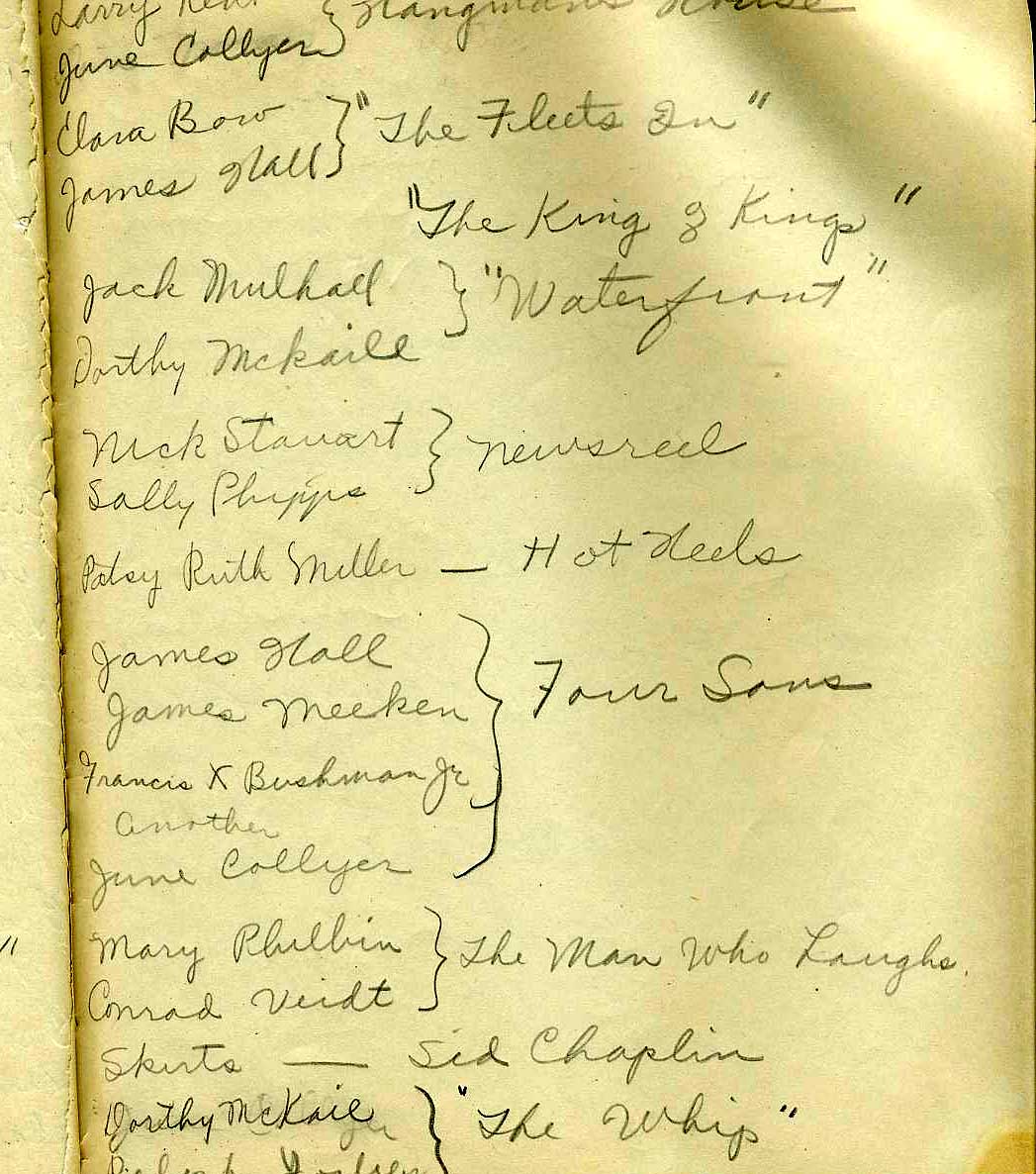
(Image above: a page from Lisa’s grandmother’s journal)
Genealogy Gems Podcast Episode #2 about transcribing family journals and letters was remastered in Episode #134.
Episode #8
Stanford Theatre, Palo Alto, CA (shows silent films)
Internet Movie Database (IMDB)
Niles Essanay Silent Film Museum: the website for this museum is packed with resources: links to Chaplin-Keaton-Lloyd film locations; the International Buster Keaton Society; Classic Images Magazine; a timeline and early history of film and more.
Films mentioned in this episode:
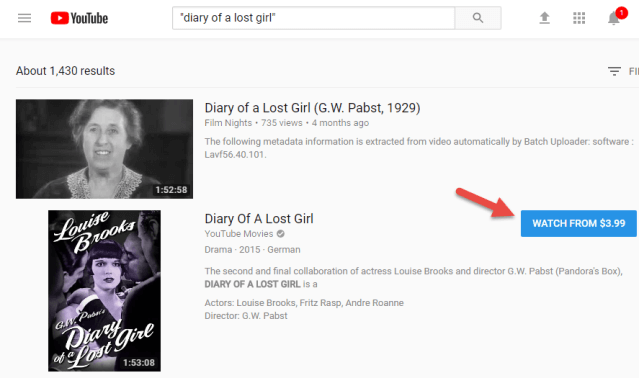
Diary of a Lost Girl starring Louise Brooks (watch trailer)
Safety Last starring Harold Lloyd (watch here)
The Mender of Nets with Mary Pickford (watch here)
The Blot directed by Lois Weber (watch here)
Don’t Park There with Will Rogers (watch here)
Flivvering by Victor Moore
Wife and Auto Trouble directed by Bill Henderson (watch here)
A Trip Down Market Street (watch here)
Wings (watch here)
All Quiet on the Western Front (watch here)
Destruction of San Francisco by Blackhawk Films (watch part here)
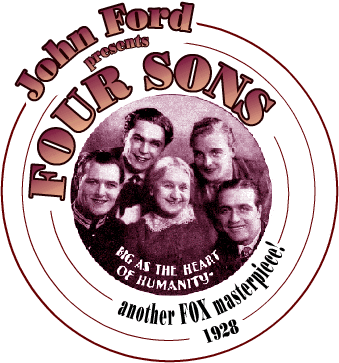
Four Sons (watch trailer)
INTERVIEW: SAM GILL, FILM HISTORIAN AND ARCHIVIST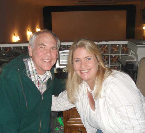
Shown here: Sam Gill and Lisa Cooke at the Niles Essanay Silent Film Museum on the day of this interview. Throughout their conversation, you hear the sounds of excited theater patrons filling the auditorium before a screening.
Sam Gill’s interest in silent film dates to 1966, when as a college student he traveled to Hollywood to interview his aging heroes from the silent screen comedy era. For more than 20 years, he was Archivist of the Academy of Motion Picture Arts and Science’s Margaret Herrick Library, where he established the Academy’s Special Collections and helped it grow to its current status as the preeminent repository for the study of American cinema. He is currently a Board Member of the Niles Essanay Silent Film Museum. Over the years, he has consulted on or otherwise contributed his expertise to numerous film festivals, museum film programs and film history books.
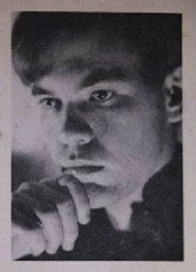
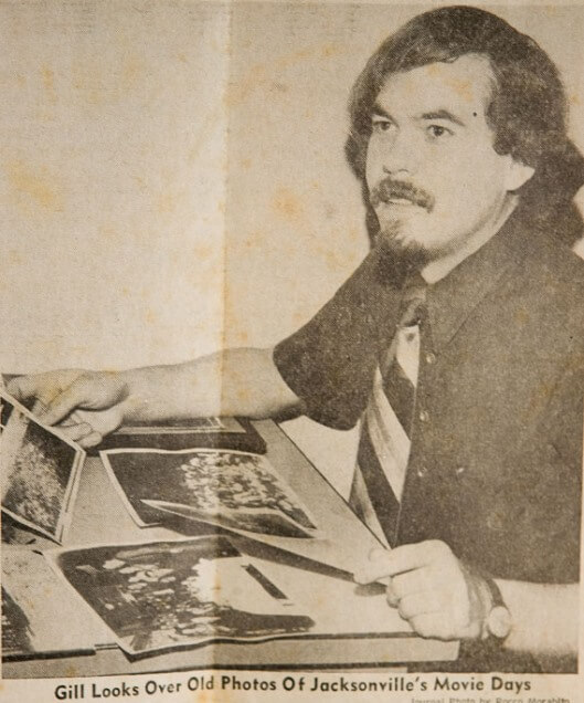
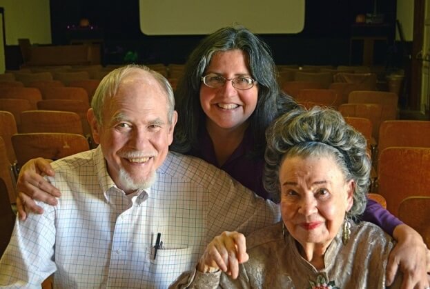
Sam recently sent us these delightful photos (below) of himself over the years:
- (Image 1) 1966: His first trip to Hollywood
- (Image 2) 1974: A news article about a research trip to Florida
- (Image 3) 2017: A birthday party for Diana Serra Cary (Baby Peggy), the last surviving star of the silent screen, held at the Edison Theater of the Niles Essanay Silent Film Museum; also shown is Rena Kiehn, the museum’s publicity director and store manager
San Francisco Silent Film Festival
How to identify old cars in photographs (a technique that adapts well to film!)
National Film Preservation Foundation (click here to see where to find films they have helped preserve, including Japanese internment camp footage)

MyHeritage.com is the place to make connections with relatives overseas, particularly with those who may still live in your ancestral homeland. Click here to see what MyHeritage can do for you: it’s free to get started.
GEM: HOW TO FIND SILENT FILMS
If you’re looking for a specific movie, start with a Google search with the name in quotations (and, if you like, anything else you know about it, such as an actor or director’s name or the year). You may find lots of results, including a Wikipedia page and film history write-ups, but if you want to WATCH it, limit your search results to Video.
You can also turn to free curated collections online, such as:
101 free silent films: the great classics (links to free film footage on YouTube, Internet Archive, etc.)
YouTube playlist of silent movies
Internet Archive Silent Films collection: feature and short silent films uploaded by Internet Archive users
Silentmovies.info: watch several classic silent films
Netflix.com: Netflix subscribers can access the service’s little-known collection of silent films by entering the Netflix link for browsing its film categories and then the category specific to silent films, 53310:
http://www.netflix.com/browse/genre/ 53310
(Click here to read an article about this tip, along with Netflix’ full list of specific film categories.)
YouTube: watch for free, rent or buy, as shown here:
More places to explore for silent films:
Turner Classic Movies (TCM.com): under TCMDb, click Database Home and search for a title you want to watch
Amazon.com: Search for titles in the Video section; or search the Classic Silent films category
Your local public library (search catalog: try searching for an actor’s name as author)
Ebay: May be the right place to purchase a hard-to-find title. Click here to view current results for a search on silent films, filtered to include only movie/film items.
PRODUCTION CREDITS
Lisa Louise Cooke, Host and Producer
Sunny Morton, Editor
Diahan Southard, Your DNA Guide, Content Contributor
Hannah Fullerton, Production Assistant
Lacey Cooke, Service Manager
Disclosure: This document contains affiliate links and Genealogy Gems will be compensated if you make a purchase after clicking on these links (at no additional cost to you). Thank you for supporting this free podcast and blog!
FREE NEWSLETTER: