Dr. Brian Gurrin is a specialist on Irish censuses and census substitutes and author of such books as Pre-census sources for Irish demography and The Irish religious censuses of the 1760s.
In this week’s video premiere he joins me for a discussion of the incredible story of the repository that held early census records and much more: the Public Record Office of Ireland.
Dr. Gurrin will take us back through the history of the building and the surprising and ironic catastrophes that destroyed countless valuable records. Then he will share the truly inspiring ways that records are being restored, some of which will be available soon!
Video Player (Live) – Watch video premiere at the appointed time in the video player above.
On YouTube (Live) – Click the Watch on YouTube button to watch the YouTube premiere with Live Chat at the appointed time above at the Genealogy Gems YouTube channel. Log into YouTube with your free Google account to participate in the live chat.
Video Player above (Replay) – Available immediately after the live premiere and chat.
If you’re looking for Irish records that were created prior to 1922, and you’re in the right place, today, we are talking about the Beyond 2020 to Ireland project, which may just be the best hope for Irish research in a long time.
Dr. Brian Gurrin is a specialist on Irish census records and substitutes. He’s also the author of the books Pre-census sources for Irish demography and The Irish religious censuses of the 1760s and he’s here today to tell us about this exciting project.
Lisa: What was held at the Public Records Office of Ireland prior to 1922? What kind of records would somebody have found there?
Dr. Gurrin: The Public Record Office (PRO) opened its doors in 1867. Prior to that the Irish records, the various state records, records of Parliament and so on, they were dispersed around in various repositories, around Dublin and around the country. Many of them were stored in locations that were unsuitable for maintaining records in good condition. The records were getting damaged, some records were getting damaged by damp and so on.
So, when the PRO opened, they started to take in records from these unsuitable repositories. There were a vast quantity of records available. Our earliest census records, our first census was held in 1813. That wasn’t a particularly successful census. And then are our next census was the first time that Ireland was fully enumerated by statutory census in 1821. And thereafter, we held censuses every 10 years on a year to terminal digit one. So, we held our census in 1821m 1831, 1841, 1851, and so on, right up to 1911, which was the last census that was held in Ireland, when Ireland was part of the United Kingdom.
And so, they were very important, very important for genealogists. And an interesting thing about the census: when the Public Record Office opened, and it just goes to show how research is changed, they published annual reports every year, the Deputy Keepers Reports. And when they opened, one of the earlier reports, I think it might have been the second report or the third report, made a comment about the census records. It talked about that the census records were just clutter taking up space and that they weren’t very important. And that they were just taking up taking up an enormous, inordinate amount of space in the Public Record Office. They didn’t want to receive any more census records because there were just basically clutter. And when you think about the census and how important the census is for genealogical research and family history research now, it just goes to show how historical research has changed, and how these records are vital records for historical research and historical study.
Overview of the background and contents of Public Record Office of Ireland:
Public Record Office of Ireland opened to public in 1867.
National repository for records:
Census returns (1813-5, 1821, 1831, 1841 & 1851)
State papers
Parliamentary records (Ireland had its own parliament until 1800).
County records; accounts, administration; grand juries.
The building destroyed on 30 June 1922; and almost all records lost.
So it was a really vast collection and it built up from 1867 right up to 1922 when it was still receiving records into the record office.
Let’s just go back and talk about the 1821 census. Again, Ireland’s first census. When that census was held, the census recorded the names of all householders in the country, but also the act that initiated the census specified that at the each of the individual counties where to make a copy of the census as well to hold locally as their own local copy of the census. But then when the county records came in after 1891, after the fire, in the Cork courthouse, all those copies of the 1821 census also came into the Public Record Office as part of the county records collection. In 1922 the Civil War the civil war commenced, and the public record was on the north side of Dublin City in the Four Courts complex, just north of the River Liffey on the north bank.
The anti-treaty IRA occupied the Four Courts complex. We’re not sure what happened. There are two schools of thought. One is that the Anti-treaty IRA deliberately mined the building and blew up the building when they were evacuating it to destroy the records which were primarily records of British administration in Ireland. So, it was a great strike for Irish republicanism, destroying the records of the British administration in Ireland. The second thought on it is that when the anti-treaty IRA started shelling the Four Courts complex to drive out anti-treaty Republican forces there, a shell went in into the Public Record Office, exploding munitions that were stored in the Public Record Office.
Whatever happened, it was quite a disaster for Irish record keeping the beautiful fantastic archive was destroyed. It was explosions that occurred on the 30th of June 1922. It was a catastrophe for Irish history. The building was destroyed, this beautiful archive was destroyed. Records going back 800 years were blown up. The records were scattered around Dublin City. Records were blown on the wind over 10 miles out around Dublin. People were picking them up and handing them back in. There were very little handed back in. It was a catastrophe for Ireland and a really great tragedy. So that’s the backstory.
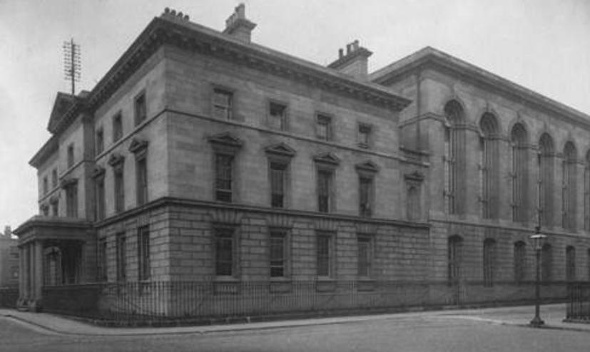
There was two parts to the records office. In designing this, they were really careful to try to ensure that nothing, no catastrophe, could happen that these records could be destroyed. There were two parts to the building. There was a squarish type building (on the left in the photo).
Ireland Public Records Office
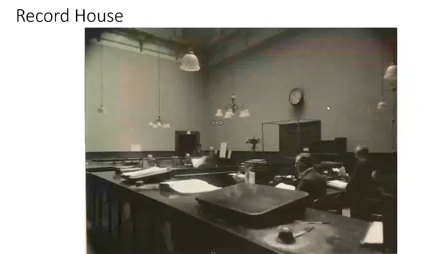
That’s called the Record House. That’s where the researchers went. If you want to access records, you went into the Record House, (it was like the Reading Room of the archive) and you filled out a form. You filled out the details of the record you wanted.
The building on the right was called the Record Treasury. It was called the Treasury because these were Ireland’s treasures. This was where Ireland’s treasures were store. It was a beautiful archive containing beautiful records of Irish history over 800 years.
If you look up towards the roof, between the two buildings, you can see a gap. This was a fire break that was that was installed because it was thought that if any fire broke out, it wasn’t going to break out in the Record Treasury, it was going to break out in the record house where the where the public came in and where the heating systems were. So, they wanted to ensure all the collections of records that were in the Record Treasury were going to be protected from fire. So that building isn’t actually joined together. That’s a false wall there. That firebreak gap between the two buildings was to ensure that there was no possibility that a fire could spread from the Record House into the Record Treasury and destroy the records.
The great irony is that when the fire broke out, when the explosions occurred, the explosions occurred in the Record Treasury. That meant that the firebreak operated in reverse protecting the Record House from the Treasury. And by coincidence, whoever was working on records on the day that the record office was occupied, those records were moved from the Treasury to the Record House for them to access. Those records remained in the Record House. So, a small quantity of records survived just by pure accident because people were using them in the Record House at the time. So, the firebreak operated in reverse, protecting the Record House from the fire that was in the Record Treasury even though it was designed with the idea that it would protect the Treasury from any fire that was going to occur in the Record house.
Lisa: Did you say that there was actually munitions stored there?
Dr. Gurrin: Just to take up on the first question that yes, they did. They were really careful to ensure that no damage could come to the records. It wasn’t just that they installed a firebreak, but they also made sure that there was no wood in the Record Treasury to ensure that there was no possibility. So everything was metal. Initially there were wooden shelves in there. But then, maybe 10, 15 years in, the Deputy Keepers annual report says, that’s it, there’s no wood left in here, We have it perfectly protected, so there is no possibility of fire occurring in here.
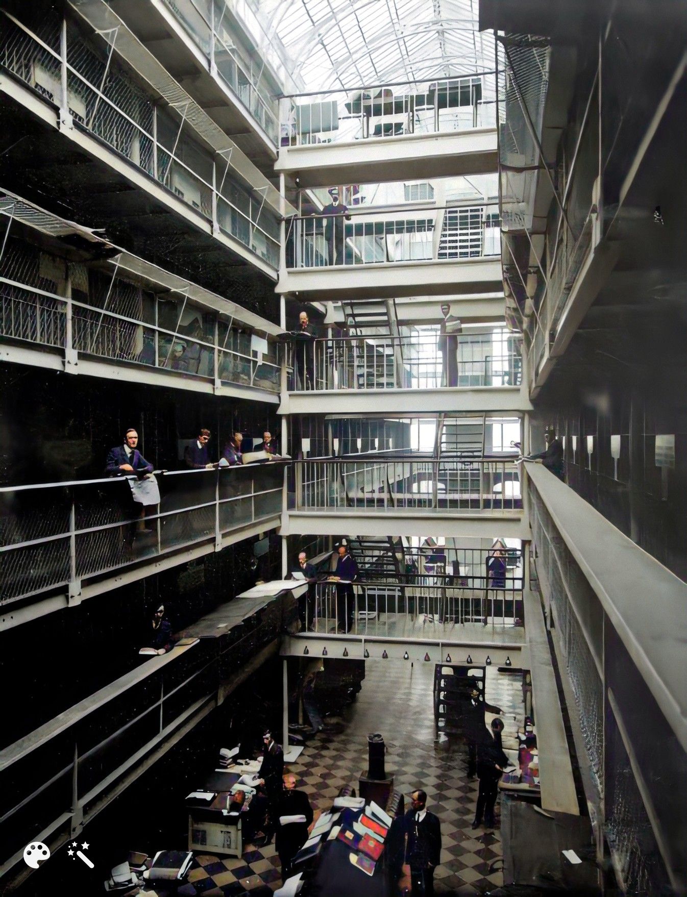
A view inside the Record Treasury:
(enhanced and colorized photo)
There were six floors in that building. You won’t see any wood at all.
These people are called searchers. So, you go into the Record House:
The Record House
You’d sit down in one of those benches down the back, you’d fill out your document, and you’d hand it up to the clerk behind the desk. They give it to one of the searchers who then goes in through those double doors. That’s the way in between the firebreak and the link into the Record Treasury. They wander up to the steps to whichever floor the record was on and find the record, and bring it back down into the Record House for you.
Now we do have a great knowledge of what was in the Record House.
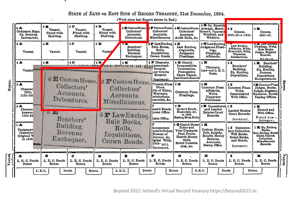
record treasury chart
There was a kind of a central aisle down. On either side there were what were called “bays”. There were six floors to it. This chart is giving you an indication of what was in the Record Treasury and what type of records were in the bays.
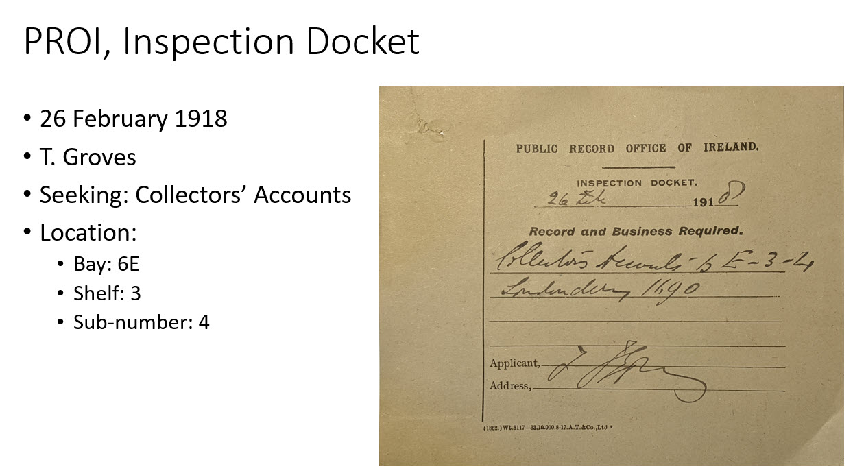
Public Record Office inspection document:
Tennyson Groves was a great hero of mine. He was a genealogist who sat in the Public Record Office and transcribed vast amounts of information from various census records. A lot of what we have surviving now are transcripts that were transcribed by Tennyson Groves.
Lisa: You mentioned the copies of records that were often made. We see that in genealogical records around the world that sometimes copies get made, and then the original set may go to a central location, and then they would keep a set locally. You mentioned that with some of the census records they actually sent the second set into the public records office as well. Do you have a sense of how many duplicates are out there? I mean, how much hope is there that there are copies of some of the things that were in the building and lost that day?
Dr. Gurrin: That’s a really good question.
Once the fire occurred in the courthouse in 1891 in Cork, they said, ‘right, we cannot have, we can’t have a situation where local records are stored in unsuitable accommodation like this. They can’t be destroyed. We have a perfectly fireproof location here. So, we’re going to take them all in.’
So, whatever records counties produced, like as I said, the 1821 census, they were required to make copies. Not all counties produced copies, and not all counties produced complete copies for their county, but many counties did. And many counties produced partial copies. All of those went into the Public Record Office after 1891 as per instructions of the Public Record Office. They all went in except for one county, which is county Cavan. About 40% of the census records survive for Cavan. They were the only county that didn’t send in their local copies into the record office. All the others transferred.
If the fire hadn’t occurred in Cork, maybe the Public Record Office would have let the records stay locally, and they would have survived. In terms of survival of records, Cavan is the only county that copies of the 1821 census survived. Now there are four volumes of 1821 census original volumes that survived. Some bits of partial sets of records have survived. That’s four out of 480 original volumes that existed. So, it’s like 1% of the original volumes from 1821 to survive. But for Cavan 40% of the county is covered by copies that were made under the terms of the census act.
Then there are transcripts for various parts from genealogists and local historians. Prior to 1922, they made copies. But in terms of survival there’s probably about, I suppose, 50 or 60,000 names surviving from 1821 and transcripts. Now that’s 50 or 60,000 names out of the 6.8 million names that were enumerated in 1821. So it’s really, really tragic.
And it’s even worse as you go as you go to the next census for 1831, the survival rate is even lower. And for 1841, it’s very low as well. And there are about two and a half thousand civil parishes in Ireland. And for 1841, there is only one parish that the original record survived. The scale of the losses is just catastrophic.
We are very lucky in that we do have census substitutes. In some instances, we have a wonderful land value taxation valuation that was conducted in the 1860s or in the 1850s called Griffiths Valuation, which is effectively a census substitute. But that’s what we’re down to as Irish genealogy. We’re down to using census substitutes in a lot of instances because unfortunately, this wonderful census records were lost.
There was one other very interesting census that was conducted in Ireland in 1766, a religious census. And that’s a real focus of our project now. It’s a magnificent survey that was conducted that is in the second book of mine that you mentioned. Some original records survive from that as well. So, that’s a really interesting focus of our project, which I could talk for hours!
Lisa: How has this loss of records been coped with over the last 100 years? Were there efforts to try to reconstruct them and fill it back in?
Dr. Gurrin: There were. As soon as the Record Office was reconstructed they did put out calls for records or records transcripts that were taken before 1922. Those came back in and were donated back into the facility. They did make efforts to recover them.
A lot of the records like the charred remains of records that were picked up around the streets of Dublin and in the vicinity of the Four Courts were collected and boxed and cataloged. Many of those records weren’t accessed again until our project started.
The National Archives has been cataloging those records that were picked up almost 100 years ago on the streets of Dublin, and they’ve been cataloging them they’ve been trying to recover them to try to treat them to make them accessible again.
There were various efforts made and donations came in from genealogists like we had a lot of genealogists who transcribed records previous to 1922. If genealogical transcripts came up in auctions the government was very active in trying to secure those. They did as much as they could do, I think, to try to recover the losses, but it was only going to be a drop in the ocean in comparison with what was there.
Lisa: Now you’ve got a brand new project called Beyond 2022. Tell us how this gets started. And what’s your end goal?
Dr. Gurrin: It’s part of the decade of the decade of Centenaries in Ireland. There were a lot of things happening around 1916, with an Easter Rising around 1918, with a general election, which saw Sinn Fein’s win the majority of the seats. It saw the War of Independence, the Civil War, and then the government of Ireland enacted the partition of Ireland. So, it was a lot of things happening around there.
Beyond 2022 really fits into that as a part of the Decade of Centenaries. It’s a two year project that’s been going on with the intention of identifying material that still exists in archives around the world and local archives here in Ireland. It’s an effort to recover it to make it freely available digitally online. They’re being digitally imaged as high-quality digital images. They are being transcribed as much as possible. And that’s not being hand transcribed. This is a transcription package, which is reading the handwriting and trying to transcribe that handwriting into searchable text.
At the end of it, it is the intention of the project to make 50 million words available and searchable through the Beyond 2022 website. So you will be able to enter a name, enter a name, enter a townland name, enter a place name, enter free text and search these documents and come back with whatever we have. The launch date is June 30, 2022.
So, you think there might be a missing census page? Whether it’s a missing census or a missing family, my special guest, professional genealogist Kate Eakman from Legacy Tree Genealogists has strategies to help you figure it out. She has just the answers you need to find your ‘missing’ family.
A Genealogy Gems reader doing genealogy research in New Jersey has lost her family! Well not literally, but she can’t find them in the 1940 U.S. Census. Here’s the email I recently received from her:
I am having a problem finding my mother and grandparents in the 1940 census. My grandfather, William Charles Opfer, was born on October 15 1900. I can find him in the 1930 census living in Glouescter Township, (Unincorporated Grenloch) Camden County, New Jersey. He is living with his wife Kathryn (Katharine) Opfer and three children: William C Jr, Robert, and Nancy (my mother).
When I search the 1940 census on Ancestry nothing shows up. So I went to the government web site and converted the 1930 Enumeration District to the 1940 Enumeration District. The 1940 Enumeration Districts were 4-57, 4-58, and 4-61. I then went through all of the pages for each of the districts looking for William C. Opfer. I did this on Ancestry, Family Search, and NARA. No William C. Opfer.
I then went back to the 1930 census and looked at his neighbors. I searched for each of the 13 heads-of-household neighbors from the 1930 census. Two had moved 1940 and I found them. I could not find the other neighbors in the 1940 census. I am wondering if a page from the 1940 census did not get scanned? Is there somewhere else I could look?
Missing Census Answers from Kate Eakman, Legacy Tree Genealogists
First, let me say how impressed I am with this Gem’s research and her dedication to finding this census report. She has made some very thorough searches and performed a number of advanced genealogical techniques in her quest for the 1940 U.S. Census page. It hardly seems fair that all that work didn’t yield the success she surely earned.
The government website she referenced is the National Archives 1940 Census page. The use of the page “1930 Records Search” allowed her to simply locate her grandfather in the 1930 U.S. Census. Then, by clicking a few buttons, discover the corresponding enumeration districts (ED) for the 1930 ED in which he and his family lived: 4-57, 4-58, and 4-61.
I, too, have scrolled through page after page searching for that one elusive name and we know how tedious that task can be! Using three different sites was a good strategy and one that we employ ourselves here at Legacy Tree Genealogists. Different images might be easier or more difficult to read, although in the case of these three EDs, the copies seemed to be uniformly easy to read.
The first two EDs were for Blackwood, an unincorporated part of Camden County, New Jersey. The third one was for the Lakeland Tuberculosis Hospital, unlikely to have housed the entire family, but certainly worth looking through in case one Opfer was a patient there.
ED 4-58 had an interesting variation at the end of the report. The last two pages were not 15A and 15B, as would be expected, but were 61A and 61B. This indicates these households were enumerated at a later date than were their neighbors. Because federal law requires every household to be counted, and because not everyone was at home when the enumerator arrived, the enumerator had to return on a different day and attempt to gather the necessary information for those families. They were recorded separately, beginning with page 61A.
People living in hotels, trailer camps, and other places normally designed for single-night stays were enumerated a week after the initial enumeration and those pages are numbered beginning with 81A. Not every ED has a 61 or an 81 page, but if you see one, now you know why the page numbers suddenly changed so dramatically.
The writer’s use of Elizabeth Shown Mills’ FAN Club was an excellent idea, too. FAN, an acronym for Friends, Associates, and Neighbors, takes advantage of the fact that people, in general, tend to remain geographically close to the people they know. [Read more about this in our post, “The Genealogy FAN Club Principle Overcomes Genealogy Brick Walls“] If a portion of a community moves, they tend to move together and relocate in the same general area of their new location. Her instincts to use this tool were excellent, even if they did not produce the desired results. This falls under the heading of “reasonably exhaustive research” and should always be included when someone, or in this case something, can’t be found, but should be there.
The fact that the researcher was able to locate only two of those neighbors could be explained, in part, by the fact that so many were in their 60s, 70s, and even 90s in 1930. They simply may have passed away in the intervening ten years. Another explanation, particularly for the working families, is that the Great Depression caused many families to move in order to find employment.
This may have been true for the Opfers. We noticed in 1930, William was employed as a supervisor for Reading Transportation. While supervisors were important to the operation of any transportation company, it is possible William found himself unemployed, as was true for millions of other Americans. If that happened, he and his family could have moved anywhere in the United States in an effort to find work. Alternatively, William may have left to find work while Kathryn and the children lived by themselves in reduced circumstances, or with family or friends.
To this end, I searched for William and Kathryn, and then each of the three children individually, in the hope of locating one or more family members. Using the “less is more” strategy which is often an important part of genealogical research, I searched with and without the family members’ ages, places of birth, and other family member’s names. Because the surname “Opfer” might have been misheard by the enumerator or grossly misspelled, I even searched for the various members of the family with no surname. Since we did not know where the family may have lived between 1930 and 1944, we included all of New Jersey, Delaware (the home state of Kathryn), as well as neighboring Pennsylvania and New York in our searches. The lack of positive results meant we needed to expand our search to the Eastern seaboard, and then the entire United States.
We also identified the names of William’s and Kathryn’s parents, William and Sallie Opfer and Raymond and Corrine Mason, and searched their households and neighborhoods for William and Kathryn. They were not there. Walter, William’s younger brother, was not hosting the family, either.
The writer had asked if it was possible that a page from the 1940 U.S. Census did not get scanned. Since the 1940 census has only been available for four years, it is still possible, although not probable, that there are one or more pages missing unbeknownst to anyone. Our research revealed only a few pages from a couple EDs in Ohio and South Dakota that were missing from the FamilySearch collection. There is no indication anywhere that there are missing pages from New Jersey. In addition, the pages in the three possible EDs for the Opfers were all included and in the correct numerical order, with no indication of any missing pages at the end. Therefore, I think we must conclude that missing pages do not explain the Opfer family’s disappearance.
Other Databases to Help
There are two other databases which might provide some insight into the location of the Opfer family. The first is the set of 1942 World War II draft registration cards. All men between the ages of 18 and 65 were required to register for this draft. The draft registration cards would have included the address at which William lived in 1942; however, there was no card for a man named William Opfer (or with only the surname “Opfer”) born between 1895 and 1905.
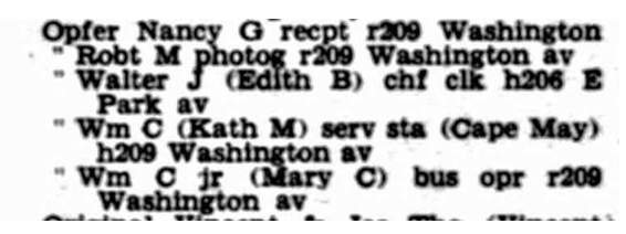
The final search was the database of city directories. A poorly-indexed city directory reported the Opfers lived in Haddonfield, New Jersey in 1943, but there are two directories contained in the same book, and the listing was actually for 1947. It reported William and Katherine lived at 209 Washington Avenue with their children William and his wife, Robert, and Nancy. William’s brother, Walter, and his wife Edith lived nearby. Unfortunately, the search for them in 1940 revealed that 79-year-old widower William Pape lived at that address with his household servants who were not the Opfer’s.
The William Opfer family in Haddonfield, New Jersey in 1947.Photo courtesy Ancestry.
Although the turmoil and upheaval of the Great Depression meant families were scattered, and it would have been easy to miss enumerating many households in the mid-1930s, by 1940 the U.S. was recovering from the effects of the Depression. Some agencies, such as the Works Progress Administration (WPA) and the CCC (Civilian Conservation Corps), were in place to provide work for men. Many war-related industries on both coasts were revived by the Allies’ efforts to stop Hitler.
In other words, there should have been work and stability for the Opfer family by 1940, and they ought to have appeared in a census report. The evidence of the 1930 census and the 1947 city directory strongly suggest they remained in or close to New Jersey, but all of the efforts to locate them have failed to yield positive results.
One Last Scenario
One possible scenario which would explain the Opfers apparent absence from the 1940 census is a simple one: perhaps the family was in the process of moving from one location to another in the month of April when the census was enumerated. Although the census was supposed to be enumerated on 1 April, the reality is that it was simply impossible to knock on every door and obtain the necessary information in one day. Some enumeration districts were fully counted by the 4th of the month. Other places were not completed until the 30th. This was true even in the same town.
If the Opfers had moved across the street from 206 Washington Avenue to 209 Washington Avenue in Haddonfield, for instance, between the 5th and the 14th of April, they would have moved from one enumeration district to another. Because the 209 Washington Avenue address had been enumerated on 4 April, they would not have been counted in that new location. And, because the 206 Washington Avenue address was not enumerated until the 15th of the month, they would not have been included in that EDs census report. We have seen this happen in the reverse and a family was enumerated twice because they moved during the enumeration, so it certainly could have happened the other way around. This is the only explanation we can find to explain the absence of the Opfers from the 1940 U.S. Census.
More About Kate Eakman at Legacy Tree Genealogists and SAVE $100!
Kate Eakman grew up hearing Civil War stories at her father’s knee and fell in love with history and genealogy at an early age. With a master’s degree in history and over 20 years experience as a genealogist, Kate has worked her magic on hundreds of family trees and narratives.
Areas of expertise:
-Native American Genealogy
-U.S. Civil War & Victorian America
-Narrative Biographies
-Irish Genealogy
The team of expert genealogists at Legacy Tree Genealogists can help bust through your brick walls. They do the research and you enjoy the discoveries!
You can use Google Slides for genealogy to create one-of-a-kind presentations, a virtual scrapbook, or a virtual library list…and it’s free! Here’s how to take advantage of yet another awesome Google tool.
I was recently asked if there was a software program or app, something free perhaps, to share a slideshow or create a visual presentation. There is! It’s called Google Slides. Here’s how Lisa Louise Cooke, author of The Genealogist’s Google Toolbox, explains it:
Google Slides is an online presentation application, much like Microsoft’s Powerpoint. It’s part of Google’s free office suite of tools. As a genealogist, it provides the opportunity to create and visually share your family history.
It’s a Cloud-based service and that means you can access your presentations wherever you are and on any computing device. You will sign-in to Google Slides with your personal Google account. That means you will be able to keep everything private unless you decide to share it. Although it’s Cloud-based, you can use it offline too. Any new presentations you create or changes you make will be automatically updated when you get back online. You can show your presentation at the next family reunion or genealogy society meeting even if there’s no Internet access.
There’s a lot of potential for using this powerful tool for genealogy!
With that great introduction, I’d like to share a few unique examples of how a genealogist or a genealogy society could use Google Slides.
Google Slides for the Genealogist
Google Slides is an easy way to create a fun slide show of your ancestor photos. This can be shared at family gatherings or reunions right from your laptop. You can also share the presentation with a click-able link.
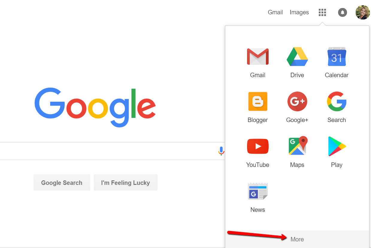
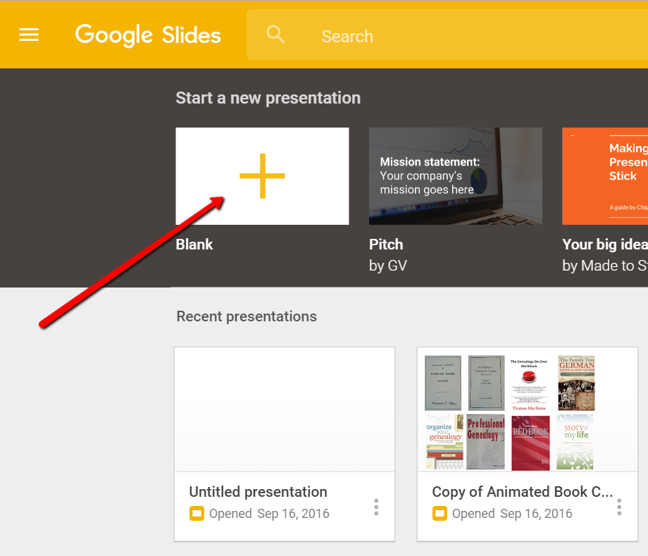
To begin, find Google Slides by going to Google.com and sign-in to your free Google account (or sign up if you don’t have one.) Click on the grid to the left of your sign-in avatar. This will bring down several options. If you don’t see Google Slides as an option, click More at the bottom.
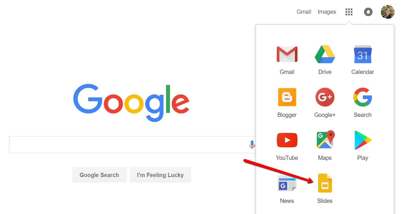
If you still don’t see Google Slides as an option, click on Even More from Google. This will take you to another screen of all sorts of Google goodies! Scroll down until you find Google Slides and click on it.
Once you have opened Google Slides, click the plus sign to begin.
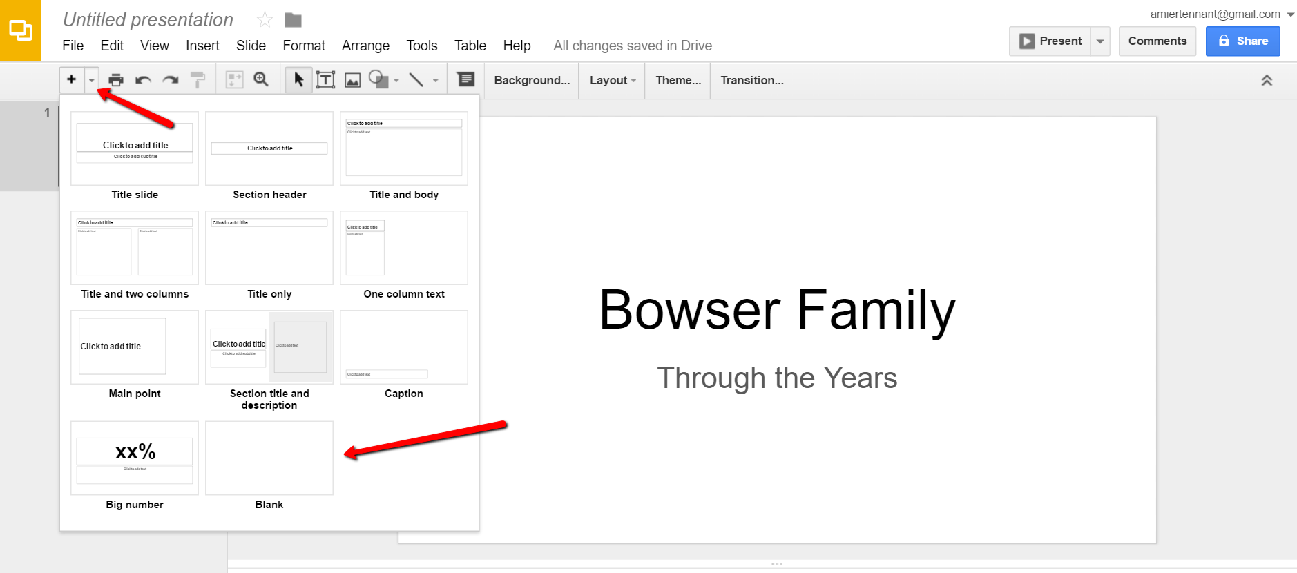
I added a title and then clicked the tiny arrow to the right of the plus sign to add a new blank slide.
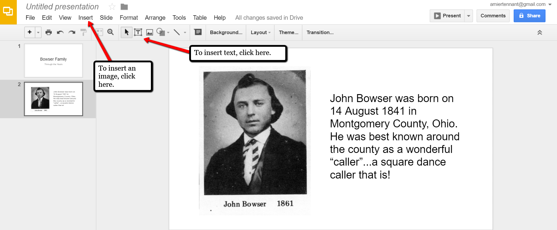
At the new slide and each additional slide, you can add a picture by first clicking Insert from the labels listed across the top, then choose Image. A pop-up window will appear and allow you to Choose an Image to Upload. You will then find the image you have saved on your computer and click Open.
Keep adding your slides until you have all of them created.
Sharing Your Google Slides Presentation
Like many of us, I like to share my ancestor photos with my family and friends. While at a family gathering of a small group, I just set my laptop up on the coffee table and we huddle around. Bring up your Google Slides presentation on your laptop or mobile device and click on Present at the top right of the screen. The computer does the rest and presents a slideshow for your viewers.
You might also wish to share your slides with family and friends far away. You can do this by sharing a link. To create a shareable link, click Share at the top right corner.
A pop-up window will appear. Click the little drop-down menu next to the words “can view.” This option allows you to choose whether you wish people to be able to edit, comment, or view only. I typically choose the “view only” option. Then, a shareable link is created for you. Click Copy link and paste that into an email directly to a family member, to your family history blog, in a Tweet, or in a Facebook post. Wa-la! You have shared your Google Slides presentation.
Create a Virtual Book Cover List with Google Slides
Another stellar way to use Google Slides for genealogy is to create a convenient virtual library list. A recent article found online gave me the idea of creating a library list using images of the covers of books.
For example, if you enjoy attending genealogy conferences and buying books for your society, you may get stuck wondering, “Do we already have that in our collection?” By creating a virtual book cover list, you won’t have to wonder anymore!
You will first need to begin this project by taking a picture of the covers of each of your books and saving the images to your computer or laptop. I took pictures, cropped them, and sharpened them up a bit with my smartphone. Then, I saved them to a file folder on my computer named Book Covers. [Tip:It would be an even better idea to save the Book Covers folder to your Google Drive!]
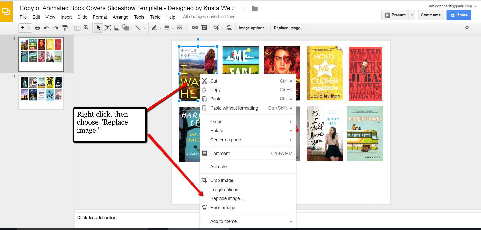
For something quick and easy, use the virtual book cover template here: Virtual Book Cover List Template. If you choose to use this link, when it opens, click Make a copy and Google Slides will open. Right click on any of the book cover images you see, a pop-up window appears. Choose Replace image and then find an image of one of your own book covers.
Once you have replaced each of the book covers with ones of your own, you can rearrange them with the click-and-drag method. You might want to put them in alphabetical order or perhaps categorize them by subject or place.
When you have finished, don’t forget to title it. There is no need to save it because Google Slides automatically saves for you. Google Slides is accessible from any of your devices and can even be viewed on-the-go from your mobile device. You’ll love this feature when you are trying to decide what books to add to your genealogy library.
How Can You Use Google Slides for Genealogy?
We are sure there are dozens of ways to use Google Slides for genealogy. Give Google Slides a try and if you think of another use for this wonderful tool, let us know about it in the comments below! Thanks for reading, friends.
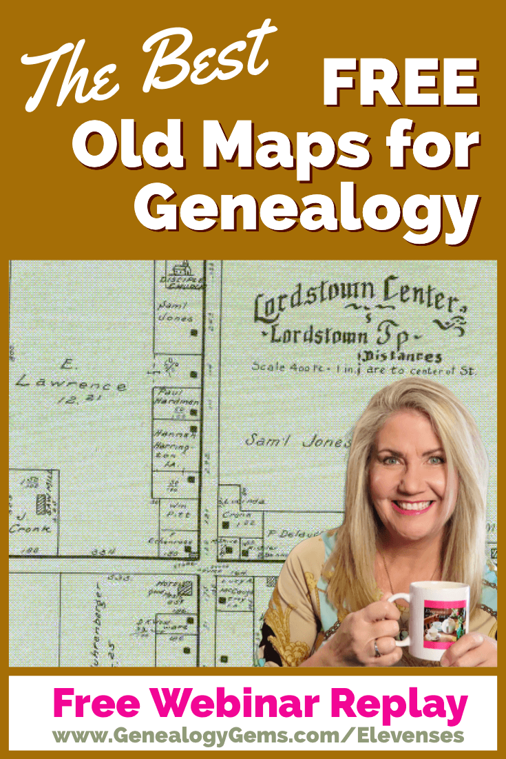
Our ability to find our ancestors is rooted in two important pieces of information: the locations where they lived and the time frames in which they lived there. This means that old maps are essential to our genealogy research.
The good news is that there is an abundance of free digitized old maps available online. One of the best resources is the David Rumsey Map Collection website. There you will find over 100,000 free digitized historic maps. These maps span the globe and centuries. They are perfect for bringing geographic perspective to your family tree.
Elevenses with Lisa Show Notes
In this episode 36 of my free webinar video series Elevenses with Lisa I’ll show you how to navigate this ever-expanding free website. Watch the video and then follow along with the show notes in this article. Here you’ll find answers to questions such as:
What’s the best way to find maps at David Rumsey’s map website?
What is the difference between the search tools (Luna Viewer and MapRank Search)?
What are the advanced search techniques for finding the old maps?
How can I download maps at DavidRumsey.com?
Is it OK to use the maps from DavidRumsey.com in my family history projects?
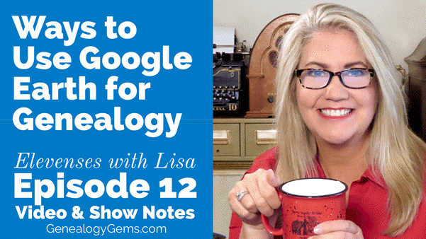
Rumsey Historical Maps in Google Earth
As we discussed in Ways to Use Google Earth for Genealogy (Elevenses with Lisa episode 12) there are approximately 120 Rumsey old maps available for free in Google Earth. You can find them in the Layers Panel under Gallery. Each map is already georeferenced as an overlay for you.
Click image to watch the video and read the article on ways to use Google Earth for genealogy
You can also create your own overlays in Google Earth using Rumsey Maps or digitized maps from other sources. I cover this step-by-step in chapter 16 of my book The Genealogist’s Google Toolbox.
Best Strategies for Finding Free Old Maps
Once you’ve exhausted the few hundred old maps in Google Earth, head to the David Rumsey Map Collection website. Rumsey’s collection includes over 150,000 map, over 100,000 of which have been digitized and are available for free on his website.
Copyright and Use Permission
You will probably be anxious to use these wonderful old maps in a variety of ways. The Rumsey website provides clear direction on copyright and use permission. Go to: DavidRumsey.com > Home Page > About > Copyright and Permissions.
The good news is that generally speaking, you are free to download and use the digitized maps for your own personal use.
The Best Way to View the Maps
There are several ways to view maps:
The Luna Viewer: Browse and search 100,000+ maps
The GeoReferencer: Help georeferenced maps, compare maps overlays
MapRank Search: Browse & search 6000 maps by time & place
Google Earth: 120 maps in the Layers panel, 140 can be added
Google Maps: 120 maps included
Second Life: View some in 3 dimensions and at a huge scale. Location: Rumsey Map Islands. Includes a welcome center with hundreds of maps, and a 600 meter tall map cylinder showing hundreds of maps.
The Collections Ticker: Pop-out distraction!
Insight Java Client: Downloadable workspace
Of this list, the best two tools to user are:
The Luna Viewer: Browse and search 100,000+ maps
MapRank Search: Browse & search 6000 maps by time & place
I will show you how to use each. Note that in these examples we will be using a computer to search the site rather than a mobile device or tablet.
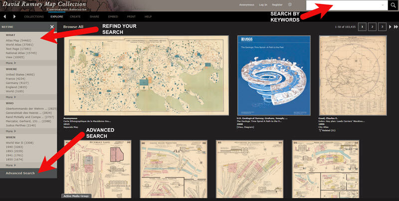
The Luna Viewer: How to browse & search the maps
In the main menu under View Collection select the Luna Viewer. Under Luna Viewer click the Launch Luna Viewer button.
The Luna Viewer at David Rumsey Map Collection
Tips for keyword searching:
In most cases it helps to start with a fairly broad search to see the full range of available maps
Be cautious with abbreviations. “MN” does not return “Minn” or “Minnestota”.
Advance search provides you with the use of full Boolean operators like “and,” “or,” “greater than,” “contains,” and others.
After a search, to return to the full collection, click on “show all” under the search button.
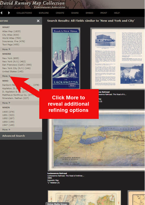
Let’s look at an example of using the keyword search in tandem with the Refine column. If you search for New York City, you will be searching all of the data associated with the maps. Since many maps may have been published in New York City, you will likely see many maps for other areas. You can improve this search by going to the Refine column and under Where clicking on New York City.
The Refine column will show you the first five options in each category (What, Where, Who, When). Click More to reveal all of the additional refining options in that category.
Click More to see all refining options in the Luna Viewer
From the returned results, click a map to view it.
You can select multiple items in the Refine column to filter more narrowly. Remove a filter by clicking it under Remove at the top of the Refine column.
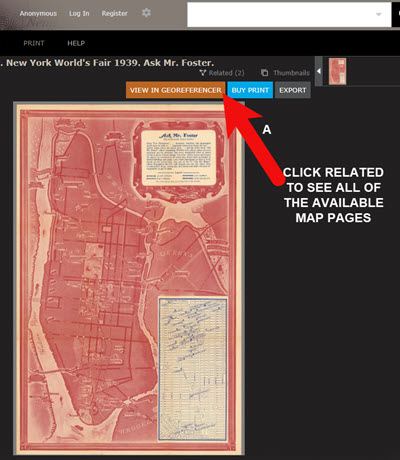
Like genealogical records, old maps may include several pages. Look above the blue BUY PRINT button to see the number of Related maps. In my example of a map of the 1939 World’s Fair in New York City, there were two map pages available. Click Related to display all of the available pages.
Click the Related link to view all related map pages.
DavidRumsey.com Advanced Search
The Advanced Search feature can be found in two locations:
Inside the search box – click your mouse in the box and select Advanced Search from the drop-down list
At the bottom of the Refine column on the left side of the screen.
Advanced Search gives you more control over how you search. Let’s look at an example by searching for Sanborn fire insurance maps.
Searching for Sanborn Fire Insurance Maps
The David Rumsey Map Collection website includes many Sanborn Fire Insurance maps. These maps were created for insurance purposes and provide an incredible amount of detail about individual buildings and dwellings in a given neighborhood.
I recommend using the Advanced Search feature to search for these maps. This is because over the years the name of the company as publisher changed.
How to Find Sanborn Maps:
Click on Advanced Search at the bottom of the Refine column
In the “find all of these words” section, click Fields and select Publisher
Type in Sanborn
On the results page, go to the Refine column and Who click More
There are at least six variations of the Sanborn publishing name.
Old Map books and atlases often include valuable historical text often called historical sketches. You can find these using the Advanced search. Search for the exact phrase Historical Sketch. Run this search and then in the Refine column under Where select an area of interest.
How to Download Maps from DavidRumsey.com
Click the map from the results list
On the map’s dedicated page click the EXPORT button at the top of the page.
Select the appropriate size from the drop-down list. (Larger maps may take a few moments to download)
Typically the maps will download to the Downloads folder on your computer
Tips for Selecting Download (Export) Map Size: Save space on your computer and future headaches by selecting the correct size map for your use. If you plan on using the map to create an overlay or create a nice large print, select the largest size possible ( I recommend at least Extra Large for creating map overlays in the Google Earth.) This will ensure that the map doesn’t appear fuzzy when you Zoom in. High-resolution is also recommended when printing. For example, if you plan on including the map in a book about your family’s history (for personal use, not for resale) a high-resolution map will print crisp and clear. Maps for use on the web or something like a PowerPoint presentation would be fine at lower resolutions.
MapRank Search at DavidRumsey.com
The MapRank Search “app” at the David Rumsey Map Collection website allows you to browse & search 6000 maps by two important criteria: Time & Place.
There are two ways to find the MapRank Search:
In the main menu under View Collection click MapRank Search. Scroll to the bottom of the page and click the Launch MapRank Search
Scroll to the bottom of the home page until you see Featured App – MapRank Search, and click the Launch MapRank Search
How to Find Maps Using MapRank Search:
Start with entering the location name in the search box (in the upper right corner) and click the Find a Place
The location will appear on the modern-day map. The old maps that match the location will appear in the column on the right, prioritized starting with the map that most closely matches what you searched.
Below the modern-day map, move the time slider levers to narrow in on the desired time frame.
Note that the old maps in the results column will change based on the specified time frame.
Broaden the location if desired by zooming out a bit on the modern-day map. Note that the results list will change as you zoom.
Hover your mouse over a map in the results list and notice that a reddish-brown box will appear the selected map and will also appear on the modern-day map. This indicates the area of the map that the old map covers. This will aid you in selecting the map that will suit your needs.
Click a map from the results list and it will open in a new browser tab, although some maps will appear as an overlay on the modern-day map. In that case, click the Luna Viewer button to go to the page where the map can be downloaded.
How to Compare Modern-day Maps with Old Maps
Whether you have found the map by searching with the Luna Viewer or the MapRank Search you will eventually find yourself on the page where the single map is displayed. On the left is the source information.
In the upper right corner of the screen click the View in GeoReferencer button. You will be taken to a page where you can view the old map overlayed on the modern-day map. In the upper right corner move the slider to make the old map transparent so that you can compare between the two maps.
Recap: Comparing the Two Best Search Tools at DavidRumsey.com
Luna Viewer: – 100,000 maps
– Search, then refine
– Sometimes glitchy interface
MapRank Search: – 6000+ maps
– More control with time slider & map
– Map results list ranked by closest coverage
Live Chat Q&A: Answers to Your Questions About David Rumsey Maps
One of the advantages of tuning into the live broadcast of each Elevenses with Lisa show is participating in the Live Chat and asking your questions.
From Megan: What is the difference between Google Earth and My Maps? From Lisa: Google Earth is a free software download. This is where I create what I call family history tours. They are a collection of data points and media that come together as a research tool and storytelling tool. My Maps are created in Google Maps. I prefer creating in Google Earth because it offers more tools and options, and it’s where I keep all my mapping work.
From Gwynn: Heard in the past Java Client might have security holes has this been fixed? From Lisa: Read more about the latest on Java Client at the website’s FAQ page.
From GeneBuds: Must set up account to use Luna Viewer? From Lisa: No, you don’t have to have an account to use the Luna Viewer. “Registering for an account allows you to save your work and preferences, search external media, create Media Groups and Presentations, customize your settings, create annotations, and upload your own content.” As I mentioned in the video, I prefer to do all my work in Google Earth.
From Gwynn: Sanborn Fire Maps: Where do I find the Key to the symbols? Are they the same from year to year or do they change? From Lisa: Here’s the main resource page for Sanborn maps at the Library of Congress. You will find specific information about interpreting the maps including Keys and Colors here.
From Karen: If you are specifically looking for plat maps for our US farmers would you put the word plat in the search field? From Lisa: I would use the Advanced Search and enter the word plat in the “Find all these words” box. Click the plus sign to add an additional “Find all these words” field and type in the name of the location. If that doesn’t deliver the desired result, omit the location and just search on the word plant. Then, on the results page, go to the Refine column and under Where click More. Then you have a nice list to browse. You might spot a map that includes your location. TIP: When you find a result, be sure to check the Related number at the top of the page so that you didn’t miss any additional pages of the map.
From Mark: Lisa and Bill, is the intro music something that you all wrote? From Lisa and Bill: No, it’s by a talented musician named Dan Lebowitz. Our goal this year was to learn to play it ourselves 🙂 We’re glad you love it as much as we do!


 The Genealogist’s Google Toolbox