by Lisa Cooke | Jan 27, 2016 | 01 What's New, Google Earth, Listeners & Readers, Maps, Research Skills
Use Google Earth for genealogy to find long-lost family locations on modern maps. Here’s how!
It can be very surprising to discover that you lived somewhere that you never knew you lived. That was the case for Professional genealogist Alvie Davidson, who recently wrote to me. He’d done some fantastic sleuthing on his own recent family history, and discovered that his family had lived in Huntsville, Alabama when he was a toddler. “This is the first I have even known they lived in Madison County, AL.” But he was not sure about how to use Google Earth to help him locate the family addresses he’d discovered.
“I have learned from the U S Government that my parents lived at (three) different addresses in Huntsville, Madison County, AL when I was a toddler in 1944….I never knew we lived in Huntsville but I learned my mother worked for munitions productions during World War II at Redstone Arsenal. She worked several months toward the end of 1944 and had to quit due to onset of pregnancy. We moved to Florida shortly after she left employment at Redstone Arsenal because we show up on the 1945 Florida State Census.”
Alvie sent me three family addresses. Then he asked for some step-by-step help instructions on how to put Google Earth to work to identify their location today.
4 Steps to Revealing More with Google Earth
1. Search each address in Google Earth. Enter the address in the search box in the upper left corner of Google Earth. If you get a hit, mark it with a placemark (clicking the button that looks like a push pin in Google Earth’s toolbar) and name it. In this case I found two of the three street addresses.
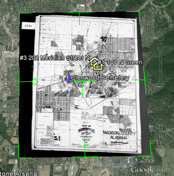
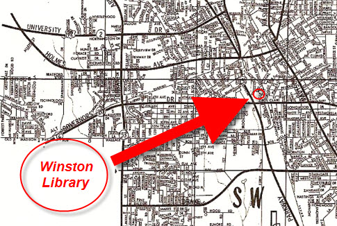
2. Locate a map of the area for the appropriate time period. With a little Google searching, I found the 1940 census enumeration map for Huntsville at the National Archives website. Here’s what that map looks like. (Image right) I then went in search of each of the three addresses on the map.
In this case, I conducted a block-by-block search of the 1940 enumeration district map for the missing address: 110 Winston Street. Unfortunately, not all the street names were clearly legible on this particular map, and I was unable to locate it.
You can learn more about locating enumeration district maps in my article How to Find Enumeration District Maps.
Genealogy Gems Premium Members: log in and watch my Premium video 5 Ways to Enhance Your Genealogy Research with Old Maps featuring instruction for locating and using enumeration district maps.
3. Overlay and georeference the enumeration district map in Google Earth to compare the past to the present. Georeference just means to match up known landmarks on the historic map with physical locations on the modern-day map, thereby allowing you to match the two maps up together. By so doing, I was able to locate on the enumeration district map the modern-day locations of the two addresses that I found using Google Earth.
There are businesses in both locations today. Below right is a screen shot showing the current location of one of those addresses. Clearly no longer the old family home.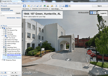
4. Dig deeper for addresses that have changed. As I mentioned previously, I searched for the 110 Winston Street address in Google Earth with no result. If that happens to you, remove the house number and run a second search on the street name alone. Numbers can change, but it is important to verify whether the street still exists today.
In this case, Google Earth did not locate a Winston Street in Huntsville, AL. Knowing that errors and typos can happen to the best of us, I ran a quick Google search for Huntsville, AL city directories, and verified that indeed Winston Street did exist at that time in history. So, at some point between 1940 and today, the name appears to have been changed.
I headed back to Google and ran the following search query:
“winston street” “huntsville alabama”
The quotation marks tell Google that each exact phrase must appear in all search results. The phrases will appear in bold in the snippet descriptions of each result.

The result above caught my eye because it mentions the “Winston Street Branch Library.” Even when street names change, buildings named for those streets often don’t. However, in this case, the website discusses the history of the library, and the Winston Street Elementary School. According to the website, the library “became a part of the Huntsville Public Library (now Huntsville-Madison County Public Library) in 1943. In 1947, the branch was renamed the Dulcina DeBerry Library.” Perhaps the street was renamed at that time as well.
Genealogy Gems Premium Members: Sign in and watch the Ultimate Google Search Strategies video class to learn more.
Jumping back into Google Earth I entered “Winston Street Branch Library” in the search box, and was immediately taken to the location, which is just south of the other two known addresses! At this point I would recommend to Alvie, who is a Genealogy Gems Premium Member, to watch my video class Best Websites for Finding Historical Maps to track down additional maps from the time frame that may have Winston Street clearly marked on the map.
Once I identified this landmark, I then marked the location with a placemark. You can turn off the 1940 enumeration district map overlay by unchecking the box next to it in the Places Panel. Doing this revealed the location on the modern day map. Finally, I headed to the Layers panel and clicked the box next to the “Roads” overlay to reveal the modern day street names.
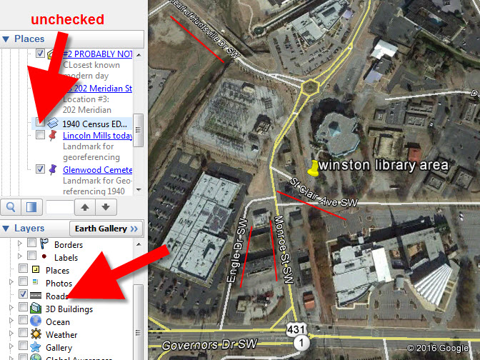
You can use this technique when you have more success than I did in finding an old address on an old map. Overlay the map, position a placemark on the location, and then turn the overlay off. With one click of the Roads layer you can now see the current street name for the old location you found on the map overlay.
Further digging online did deliver additional maps from the era and area:
We all have locations in our family history that have given way over time to new buildings and parking lots. By using the power of Google Earth, Google search, and historic maps, they don’t have to be lost forever.
Get Started with Google Earth for Genealogy
Learn all these Google skills–with step-by-step tutorials and video demonstrations–in Lisa’s book and Google Earth video tutorial. Click here for a special price on the bundle!
FREE video: Get Started with Google Earth for Genealogy
Google Bundle! The Genealogist’s Google Toolbox Second Edition PLUS learn how to create your own historical map overlays in my Google Earth for Genealogy 2-video CD set.
Use Google Earth to Plot Your DNA Matches
by Lisa Cooke | Apr 24, 2016 | 01 What's New, Google, Google Earth, Listeners & Readers, Maps, Memory Lane
 Thom learned how to use Google Earth for family history after watching my free Google Earth for Genealogy video, and then made a landmark discovery: his ancestors’ pond, business and a photo of his family at work.
This Using Google Earth for Family History success story was recently sent in by Thom, a young genealogist who blogs at The Millennial Genealogist. Be sure to click on the picture that goes with his story–it’s really neat.
Thom’s Google Earth Story
“I am writing to share with you a TOTAL (and entirely unexpected) success in using Google tools for my research.
By way of introduction, I am a young genealogist (age 21) from Massachusetts. I recently discovered your podcast and have been working through the archived episodes on my daily 1.5 hour commute.
I watched your Google Earth presentation last weekend, and had some time to try your tips out after work today.
My family has strong roots in North Attleboro, Bristol County, Massachusetts. So I decided that my first task would be to find a good historical map to overlay. A quick Google search yielded a 1943 USGS map of the greater Attleboro area on the University of New Hampshire website. Some quick adjustments left me with this great result:

My curiosity having been piqued, I began exploring the map. I know that two sets of my second-great-grandparents, Bert Barrett and Grace Freeman, and James Adams and Elizabeth Todd, all lived near Oldtown Church (presently the First Congregational Church). I zoomed in:

Looking at Google’s current street names, Oldtown Church is right by the intersection of Mt. Hope and Old Post (you’ll note the small cross). Now keep following Mt. Hope Street – do you see what I see? Todd’s Pond! I just knew this couldn’t be a coincidence. So I went straight to Google again:
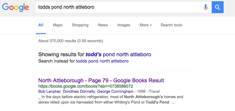
And the very first result, a page within a Google Book on the history of North Attleboro, was astonishing:
“In the days before electric refrigeration, North Attleborough’s homes and stores relied upon ice harvested from either Whiting’s Pond or Todd’s Pond (depicted here).
By the time this 1906 photograph was taken, farmers George, Henry, James, and William Todd found selling ice more profitable than farming and founded the Oldham Ice Co.
Todd’s Pond was located on the westerly side of Old Post Road near the corner of Allen Avenue. The Oldtown Church is visible in the background.”
From North Attleborough by Bob Lanpher, Dorothea Donnelly and George Cunningham (Images of America series, Arcadia; click here to see the picture that goes with this photo, along with other pictures he found with a follow-up visit to the area.)”
Mentioned by name are great-great-grandmother Elizabeth’s four brothers, George, Henry, James, and William Todd. What a spectacular find!
I plan to reach out to the local museum that prepared the book to see if they can provide a better copy, and even additional media should I be so fortunate.
In short, I wanted to take a moment to say THANK YOU so very much! Had I not been exploring Google Earth at your suggestion, I’m not sure if I ever would have ever noticed “Todd’s Pond.”
The Power of Google Used for Genealogy
I hope you are using Google Earth for family history! Paired with Google Books and the rest of rest of Google’s genealogy tool box, it can help you unearth fascinating facts about your family history.
Here’s an image I found (using Google Images) that shows the process of harvesting ice, a profession long gone with the age of modern refrigeration.

The ice trade around New York; from top: ice houses on the Hudson River; ice barges being towed to New York; barges being unloaded; ocean steamship being supplied; ice being weighed; small customers being sold ice; the “uptown trade” to wealthier customers; an ice cellar being filled; by F. Ray, Harper’s Weekly, 30 August 1884. Public domain image, Wikimedia Commons. Click to view.
Resources for Using Google Earth for Family History
In my book, The Genealogist’s Google Toolbox, I’ll teach you how to use Google Earth for family history, along with Google Books, Google Images and more.
My Google Earth for Genealogy video tutorial series will then round out your education.
Both are packed with step-by-step instructions and examples from my own family history research to inspire you. Google and all its powerful tools are FREE. Why not invest some time in learning to harness its power?
More Google Earth for Family History Success Stories
Click below to read more Genealogy Gems articles on how you can use Google Earth for your family history research:
Alvie Discovers His Unknown Childhood Home: 4 Steps for Using Google Earth for Genealogy
Was This My Ancestor’s Neighborhood?
Have you had success using any of these techniques? Please leave a comment below.
by Lisa Cooke | Feb 12, 2018 | 01 What's New, German |
For a long time, German census records were thought not to exist. But they do! A leading German genealogy expert tells us how they’ve been discovered and catalogued—and where you can learn about German census records that may mention your family.
Thanks to James M. Beidler for contributing this guest article. Read more below about him and the free classes he’ll be teaching in the Genealogy Gems booth at RootsTech 2018 in a few short weeks.
German census records DO exist
One of the truisms of researching ancestors in America is that the U.S. Census is a set of records that virtually every genealogist needs to use.
From its once-a-decade regularity to its easy accessibility, and the high percentage of survival to the present day, the U.S. Census helps researchers put together family groups across the centuries.
On the other hand, the thing that’s most distinctive about German census records is that for many years they were thought not to even exist.
For Exhibit A, look at this quote from a book published just a few years ago: “Most of the censuses that were taken have survived in purely statistical form, often with little information about individuals. There are relatively few censuses that are useful to genealogists.”
The book from which the above statement was taken is The Family Tree German Genealogy Guide. And the author of that book is … uh, well … me!
In my defense, this had been said by many specialists in German genealogy. The roots of this statement came from the honest assessment that Germany, which was a constellation of small states until the late 1700s and not a unified nation until 1871 when the Second German Empire was inaugurated, had few truly national records as a result of this history of disunity.
As with many situations in genealogy, we all can be victims of our own assumptions. The assumption here was that because it sounded right that Germany’s fractured, nonlinear history had produced so few other national records, those census records didn’t exist.
A few census records from northern German states (see below) had been microfilmed by the Family History Library, but for all intents and purposes, a greater understanding of the “lost” German census records had to wait for a project spearheaded by Roger P. Minert, the Brigham Young University professor who is one of the German genealogy world’s true scholars.
Finding lost and scattered German census records
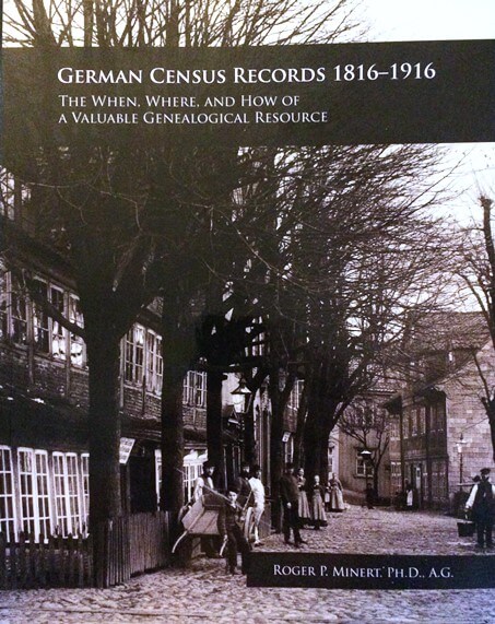
It can be said that Brigham Young University professor Roger Minert “wrote the book” on the German census. That’s because he literally did: German Census Records, 1816-1916: The When, Where, and How of a Valuable Genealogical Resource. A sample page is shown below.
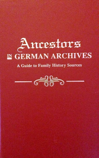
Minert had a team help him get the project rolling by writing to archivists in Germany before he took a six-month sabbatical in Europe. During this time, he scoured repositories for samples of their German census holdings (To some extent, Minert’s project had echoes of an earlier work led by Raymond S. Wright III that produced Ancestors in German Archives: A Guide to Family History Sources).
What resulted from Minert’s project was the census book and a wealth of previously unknown information about German censuses.
While a few censuses date to the 18th century in the German states (some are called Burgerbücher, German for “citizen books”), Minert found that the initiation of customs unions during the German Confederation period beginning after Napoleon in 1815 was when many areas of Germany began censuses.
The customs unions (the German word is Zollverein) needed a fair way to distribute income and expenses among member states, and population was that way. But to distribute by population, a census was needed to keep count, and most every German state began to take a census by 1834.
Until 1867, the type of information collected from one German state to another varied considerably. Many named just the head of the household, while others provided everyone’s names. Some include information about religion, occupation and homeownership.
The year 1867 was a teeter-totter point Minert calls it “for all practical purposes the first national census.” Prussia—by then the dominant German state and whose king would become the emperor just a few years hence—spearheaded the census effort.
After the founding of the Second German Empire, a census was taken every five years (1875 – 1916, the last census being delayed by World War I). While there was some variance in data from one census to another, they all included the following data points:
- names of each individual,
- gender,
- birth (year and, later, specific dates),
- marital status,
- religion,
- occupation,
- citizenship,
- and permanent place of residence (if different from where they were found in the census).
While some of these censuses are found in regional archives within today’s German states, in many cases the census rolls were kept locally and only statistics were forwarded to more central locations.
Interestingly, there has been a lack of awareness even among German archivists that their repositories have these types of records! Minert says in his book that in three incidences, archivists told him their holdings included no census records, only to be proved wrong in short order.
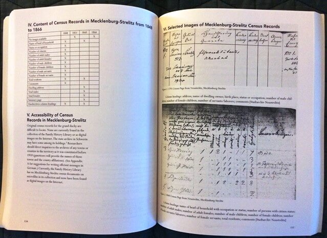
Minert’s book goes through the old German Empire state by state and analyzes where researchers are likely to find censuses. For each state, there is also a chart on the pre-Empire censuses and what information they included.
Researchers wishing to access these records will often need to contact local archives. If you’ve uncovered a village of origin for an immigrant, you could contact them directly by searching for a website for the town, then emailing to ask (politely but firmly) whether the archives has census records.
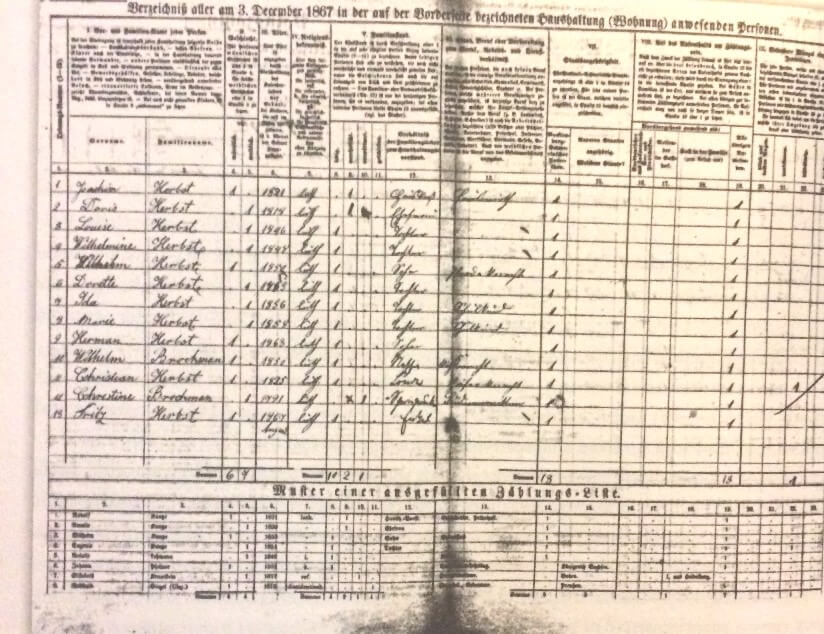
FamilySearch has placed online German census records for Mecklenburg-Schwerin (1867, 1890 and 1900; the one shown below is from 1867).
The Danish National Archives has some census records online for Schleswig-Holstein (much of the area was Danish until they lost a war with Prussia in 1864).
Other Census-Like Lists
In addition to these censuses, many areas of Germany have survivals of tax lists that serve as a record substitute with some data points that are similar to censuses. The lists generally show the name of the taxpayer and the amount of tax paid.
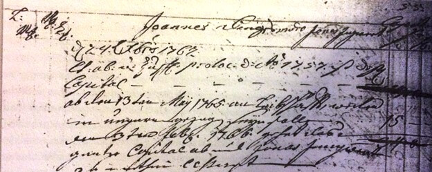
In some cases, versions of the lists that include the basis for the tax (usually the value of an interest in real or personal property) have survived. The lists may also include notes about emigration. Here’s a sample tax record from Steinwenden Pfalz.
Some of these tax lists are available in the Family History Library system.
The best “clearinghouse” that reports the holdings of various repositories in Germany is Wright’s Ancestors in German Archives. As with the census records, the best way to contact local archives directly would be to search for a website for the town. E-mail to ask whether such lists are kept in a local archive.
In my personal research, tax records have proved crucial. For example, they confirmed the emigration of my ancestor Johannes Dinius in the Palatine town of Steinwenden. These records showed the family had left the area a few months before Dinius’ 1765 arrival in America.

James M Beidler is the author of The Family Tree German Genealogy Guide and Trace Your German Roots Online.
Disclosure: This article contains affiliate links and Genealogy Gems will be compensated if you make a purchase after clicking on these links (at no additional cost to you). Thank you for supporting Genealogy Gems
by Lisa Cooke | Apr 23, 2015 | 01 What's New, 1950, Census
The 1950 federal U.S. census will not be released to the public until April 2022. Are you as excited about that as I am? This census will provide volumes of new information about our families and their lives.
An enumerator interviews President Truman and the First Family for the 1950 Census. Image from www.census.gov.
Answers to Your Questions about the 1950 Census
Here are answers to four of the common questions we receive about the 1950 census:
What will I be able to learn from the 1950 census?
With each decade the federal government has asked more detailed questions. The information collected has expanded our understanding of the families, their backgrounds, and their lifestyle.
Here’s what the front page of the 1950 Census of Population and Housing form looked like:
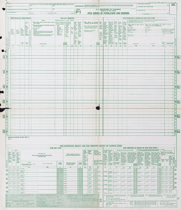
As you can see there is a wealth of information that will be of interest to family historians. 20 questions were asked of everyone. The detailed questions at the bottom of the form were asked of 5% of the population.
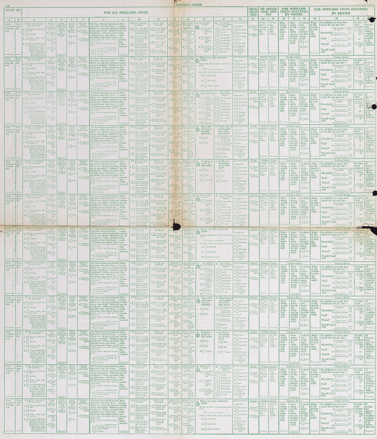
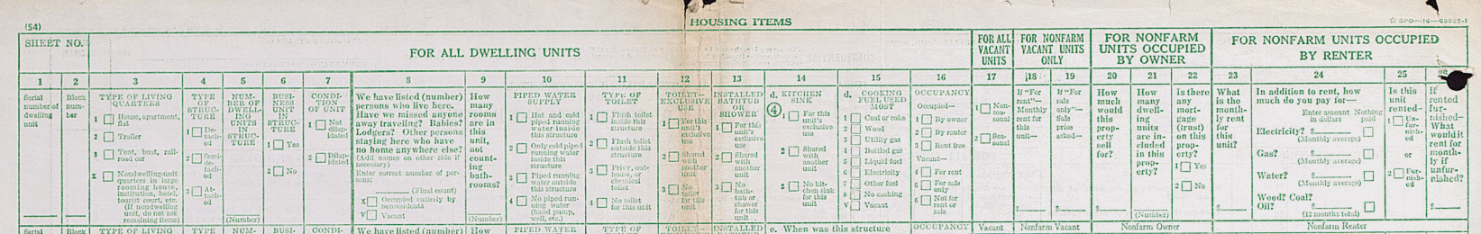
The back side of the form may not be as familiar to you, but it too collected a vast amount of fascinating data about housing:
Let’s take a closer look at one of the rows:
Instructions regarding the front and back of the Population and Housing Schedule Form P1
As you can see the back side of the form is focused on housing. Here you’ll find answers to questions about:
- Type of Living Quarters
- Type of Structure
- Whether a business was run from the house
- The condition of the building
- If there are any inhabitants who may be somewhere else at the time the census was taken
- How many rooms
- Type of water, toilet and shower / bath facilities
- Kitchen and cooking facilities
- Occupancy
- Financial and rental arrangements
Additional questions were not asked of all, but rather were asked on a rotating basis. These centered around additional features of the home such as radio, television, cooking fuel, refrigeration, electricity and the year the home was built.
Are enumerator instructions available for the 1950 census?
The instructions issued to enumerators can provide you with further insight into the records themselves. It can also clarify the meaning of marks and numbers you may find on the documents.
And yes, the US Census Bureau has indeed published the instructions for the 1950 census on their website here. According to their site:
“During the 1950 census, approximately 143,000 enumerators canvassed households in the United States, territories of Alaska and Hawaii, American Samoa, the Canal Zone, Guam, Puerto Rico, the Virgin Islands, and some of the smaller island territories. The U.S. Census Bureau also enumerated Americans living abroad for the first time in 1950. Provisions were made to count members of the armed forces, crews of vessels, and employees of the United States government living in foreign countries, along with any members of their families also abroad.”
Also on that web page you’ll find instructions for the following years: 1790, 1850, 1860, 1870, 1890, 1900, 1910, 1920, 1930, and 1940.
Can I request individual census entry look-ups?
Yes, you may apply to receive copies of individual census entries from 1950-2010 for yourself or immediate relatives. It’s not cheap—it’s $65 per person, per census year. (Check the website for current pricing.) But if you’re having research trouble you think would be answered by a census entry, it might be worth it. Click here to learn buy lithium medication online more about the “Age Search Service” offered through the Census Bureau.
Is there a 1950 census substitute database?
Yes, Ancestry has one. You might find it a little gimmicky, because it’s just taken from their city directory collection from the mid-1940s to the mid-1950s. But it’s a good starting point to target your U.S. ancestors living during that time period. The annual listings in city directories can help you track families from year to year.
More 1950 Census Resources
Your 1950s family history may appear in other records as well, and I’ve got some tips to help you in your search:
Watch my video All About the 1950 Census.
