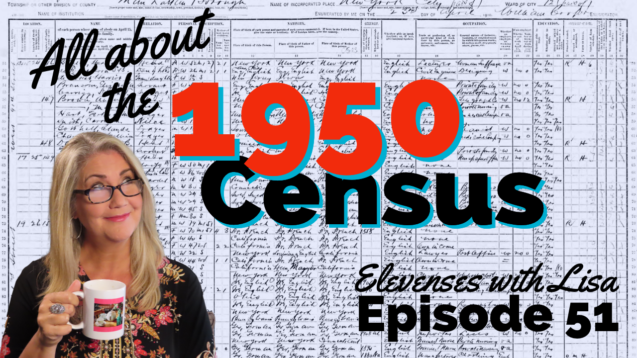
1950 US Census Maps – How to Find and Use Them
In Elevenses with Lisa episode 79 Lisa Louise Cooke explains:
- How to find 1950 US Census Enumeration District (ED) Maps
- The purpose behind them and how to interpret the maps
- Ways to use the maps for your genealogy
This is a follow up to episode 51 on The 1950 Census for Genealogy. In that episode I discussed the importance of finding your ancestors’ enumeration district numbers in order to be able to find them when the digitized images are released (before the index is available.) In this episode I will walk you through how to locate the enumeration district (ED) number and then find the actual 1950 US Census ED map. We’ll wrap things up with a quick update on the release of the 1950 US Federal Census.
Episode 79 Show Notes
(Get your ad-free Show Notes Cheat Sheet at the bottom of this page in the Resources section.)
As I mentioned in Elevenses with Lisa episode 51 The 1950 Census for Genealogy, prior to 1880, U.S. Marshalls were the enumerators for the federal decennial census. Starting with the 1880 census enumerators were hired and they were each assigned an enumeration district, also known as an ED. These districts had to be mapped out so that the enumerators knew the area they were responsible for counting. Therefore, maps are drawn in anticipation of each census being taken, including the 1950 census.
Learn more by watching episode 51 on the 1950 census.
About the 1950 US Census Maps
It’s always important to understand the purpose of a record or source, and the 1950 Enumeration District maps (ED maps) are no exception. Unlike most maps where it’s all about accurately drawing up the current roads and geographical features, census ED maps are drawn up for the purpose of defining boundaries for the purpose of counting people. This means as we look at ED maps we need to keep a few things in mind.
The first thing to understand is that the 1950 ED maps were not necessarily up-to-date with the lay of the land in 1950. Not all streets, parks and features will be included. The reason for this is that the maps themselves were not created for this purpose. Existing maps were used and then enumeration district boundaries were drawn on them.
Maps came from a variety of sources including but not limited to county and City Planning Commissions, 1940 census bureau tract maps, and city engineers. In fact, from a mapping perspective the variety of maps in the collection are fascinating.
Look for the map title, description, legend and census stamps typically found in one of the corners. In this example (see image) from Aurora, Colorado the map used was originally created by the city engineer in 1946 and was revised in 1947.
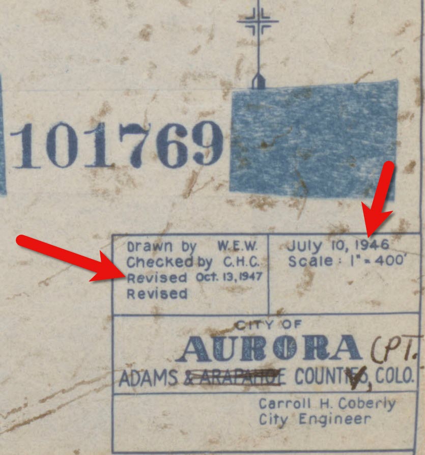
1950 census map of Aurora, Colorado (Source: National Archives)
Following the end of World War II, the United States was growing at a quick pace in 1950. This is particularly true of the newly emerging suburbs. Therefore, if your ancestors built a new home in a new development in 1949, don’t be surprised if you don’t see the street on the 1950 census ED map. However, rest assured that the maps still hold value for your family history as they provide many interesting and unique details about the area surrounding your ancestors’ homes.
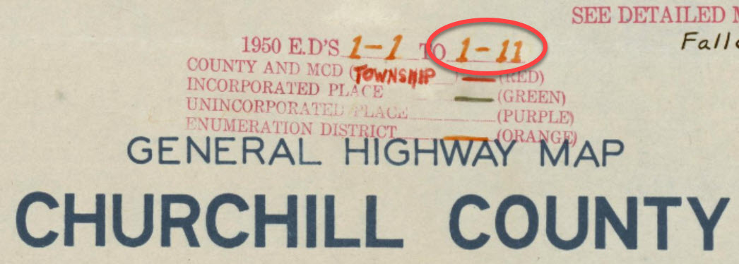
Each map was stamped with a small legend where the meaning for each of the colored lines drawn could be indicated. From my random sampling of 1950 census maps across the United States it appears that the coloring coding was consistent as follows:
- Red = Township
- Green = Corporate Limits/Ward
- Orange = Enumeration District
Expect to see errors, inconsistencies and omissions in the maps. The more rural the area the more likely the map was compiled from several sources by the Census Bureau cartographers. This compilation created more opportunity for errors, and often used older maps.
Source: National Archives
The Meaning of Census Enumeration District Numbers
A census enumeration district number is made up of two numbers separated by a dash. The first number (in this example: 1) represents the county/region. The second number represents the area within the county that could be covered by an individual census enumerator within the amount of time provided for taking the census, about 2-4 weeks. The official start of the 1950 US Federal Census was April 1, 1950.
Census enumeration district (ED) numbers on a 1950 census map.
How to Find 1950 Census Maps
Some 8,000 census maps have been digitized and are available at the National Archives. However, the National Archives website can be challenging to navigate. I recommend using the Unified 1880-1950 Census ED Finder Tool at Steve Morse’s website.
1. Go to https:/stevemorse.org
2. In the menu in the upper left corner hover over US Census and in the secondary menu click Unified 1880-1950 Census ED Finder
3. Select the state from the first drop-down menu.
4. Next select the county.
5. Then select the city.
6. You will then see many enumeration district links listed. In order to find the right one for your ancestor’s home, enter the house number and select the street from the next drop-down menu. Don’t worry about directional parts of the address like west or east unless they are offered in the list of street names.
7. As soon as select the street name, the list of ED numbers should be reduced. In this example we are down to three.
8. To further reduce the possible ED numbers, we can select Cross or back street on same city block. If you’re not sure what the neighboring streets are, click the see Google Map This will plot the address you entered into Google Maps where you can then find the closest cross street, and the next streets over. If the address is not precisely marked on the map, check the address that appears in the Google Maps search box.
In my case, the One-Step tool didn’t allow me to specific W. Arcade, so Google Maps just gave me the general area, and not the address. By adding the W. to the address and pressing enter on my keyboard Google Maps was able to precisely plot the location. Now we can make note of the closest cross street (ex. N. Center), the street north of the address (E. Monterey Ave.) and the street south of the address (W. Noble St.)
9. Head back to the Unified 1880-1950 Census ED Finder page and enter each nearby street (you can enter multiple.) This should reduce the ED numbers one. This is the ED that includes your ancestor’s address.
How to Find 1950 Census Maps
1. Make note of the ED number, and then go back and click the button that says See ED Maps for ____________ County. You could have clicked this button without going through the process of locating the ED number, but the ED number makes it much easier to find your ancestor’s home street on the map. This number will also assist you in being able to find your ancestors in the 1950 census before it is indexed.
2. You will now be on the Viewing 1950 Enumeration District Maps in One Step Re-enter the city from the drop-down menu.
3. Click the Get ED Map Images You will receive two links. The first link is Links to NARA viewer will take you to the page on the National Archives website which includes all of the information about the map and the record hierarchy. Source citation information can be gathered from this page.
5. Click the second link called Direct links to jpegs on NARA server. This will take you to the image by itself as hosted on the National Archives website. I find this the easiest way to save the full resolution image to my computer hard drive. On my PC I right-click on the map and select Save Image As.
This page is also important if you want to use this image in another program such as Google Earth. The URL for this page is the direct URL to the image. Notice that it ends in .jpg. This means that it is the image alone, and this link can be used to create a custom map overlay in Google Earth. You can see an example of a custom map overlay in my video Create a Family History Tour with Google Earth Pro at the 06:13 mark.
Resources
- Download the ad-free show notes (Premium Member log in required. Not a Premium Member? Become a Genealogy Gems Premium Member.)
- Subscribe for free to our Genealogy Gems YouTube channel so you’ll never miss another episode.
- Subscribe to my free email newsletter to get notifications of new videos and articles.
Bust a Brick Wall by Speaking Google’s Language

Bust a genealogy brick wall by learning to speak Google’s language. Proper use of Google’s basic search operators will have you plowing through walls in your research in nothing flat!
Genealogy information is sprinkled across the millions of websites on the web. Whether it’s a digital image of your great-great grandma on a distant cousins website or an out-of-print history book listed in the online card catalog in a library on the other side of the globe. Google can help you find it all.
Gaining access to that information is not as hard as you may think. I’d like to share a question I received recently from a Genealogy Gems Podcast listener, and show you how you can bust a brick wall by speaking Google’s language.
Here’s the email that I received from Ruth last week:
I’m sitting here listening to one of your free podcasts…I’m working, I’m listening, and I’m thinking…about my brick wall James Craig, what I know and what I’m trying to find out!
I know that James Craig was born about 1795-97 in New Jersey and was at Ft. Jesup, Louisiana in 1823, [and] that he was discharged in 1825. I researched New Jersey military records and found a James Craig, from Pittsgrove, Salem, New Jersey, who joined the Army [in] August 1820 for five years [and] he was sent to Fort Scott, Georgia. I read articles that state, when Fort Scott closed sometime around 1822/23, the men were sent to Fort Smith, Arkansas. Do you see the trail I’m following? It’s not hard to make the connection from Fort Smith, Arkansas to Fort Jesup, Louisiana. My problem is that I haven’t found any transfer papers!! So, how do I verify that James Craig from Pittsgrove, New Jersey is my 3rd great-grandfather. Is it possible that there are journals from the commanding officer of each encampment that might shed some light on this?
Thanks in advance for any thoughts you might have on this long standing brick wall!
Tips to Bust a Genealogy Brick Wall
Ruth asked “Is it possible that there are journals from the commanding officer of each encampment that might shed some light on this?” I certainly think it is possible! I would suggest using Google to search the web because such items might be digitized online, or they might be listed on a library or archive website as being available at their location. Either way, you would gain valuable information on how to access the items.
Here’s an example of a search I would run:
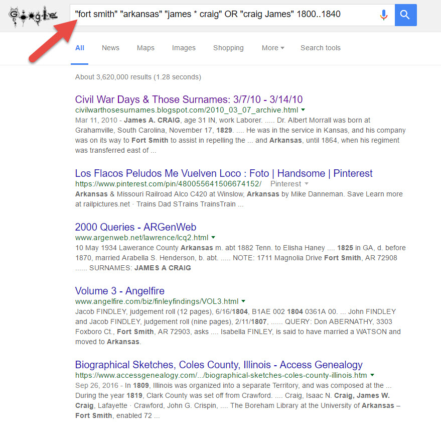
This search is based on my Google Excellent Method Search Let’s break down the pieces of this search query:
The quotation marks tell Google that the word or phrase must be in every search result (in other words, they are mandatory.) When used around a phrase, that means the phrase must appear exactly as searched.
The asterisk tells Google there might be a word or two between the words in a phrase, such as a middle initial.
By putting OR between two versions of the phrases, such as last name first and first name first, you cover all your bases. Note that the word OR must be capitalized to work as a Google operator.
Finally, two numbers separated by 2 dots is called a “numrange search” and that tells Google a number that falls within that range must appear in each search result. And of course, four digit numbers represent years to genealogists!
Your Genealogy Google Guru
Google packs a powerful punch for genealogists. Let me be your Genealogy Google Guru and watch my video below for even more helpful tips and tricks. Remember to subscribe to my Genealogy Gems YouTube channel so you’ll get all my upcoming Google video tips. Happy searching!
Ellis Island Records! BEST Search Strategies
The free Ellis Island Passenger Search database is home to 65 million records of passengers arriving at the Port of New York from 1820 to 1957. Kathryn Marks, Manager at The Statue of Liberty-Ellis Island Foundation explains the best strategies for finding your ancestors’ passenger list records in the Passenger Search Database on the Ellis Island website. Along the way, you’ll learn some surprising facts about Ellis Island and these invaluable records that will have your genealogy jumping for joy!
Watch the Video
Show Notes
Downloadable ad-free Show Notes handout for Premium Members.
Information You Can Find in Passenger Lists
Here’s a list of the type of information you may be able to find in passengers lists, depending on the year:
- Name
- Age
- Place of Birth
- Physical Description
- Occupation
- Last Place of Residence
- Where they are going
- Ship name
What Else You Can Find at the Ellis Island Passenger Search
- Crew Manifests
- Ellis Island Detention Records and Records of Special Inquiry
How to find Ellis Island records about detained passengers:
- Find the manifest in the database.
- Look to the left of the name for markings. X or SI stands for Special Inquiry indicates the person was probably held on Ellis Island. LPC: Likely to Become a Public Charge.
- Detention records will tell you why they were detained. Detention records aren’t indexed. You can find them by locating the manifest first, and then scrolling through the carousel of images to find them at the beginning or end of the ship’s list.
- Determine the length of your ancestor’s detention by counting the number of meals recorded.
Ellis Island Records Through the Years
Ellis Island records coverage: 1820-1957
Pre-Ellis Island AKA Castle Garden Era Records: 1820-1892
Before 1892: Castle Garden was the state-run immigration station. The federal government took over the process of immigration, they built Ellis Island in 1892.
Pre-1897: Records are technically customs records. That’s why they have a very limited amount of information. Manifests were destroyed in a fire in 1897.
Peak Years at Ellis Island: 1892-1924
After 1907: Passenger lists became 2-page documents containing approximately 30 questions.
1924: Ellis Island’s focus turned to detention and deportation. Therefore, most people wouldn’t have actually stepped foot on Ellis Island.
Ellis Island closure: 1954
Records available through: 1957
Records were created at the port of departure. Upon arrival, Ellis Island inspectors asked the passenger the same questions to make sure they were answered the same way.
How to Search for Ancestors at Ellis Island Passenger Search
- Go to the Ellis Island Passenger Search page.
- Type your ancestor’s name into the search bar.
- Select from a variety of wild card searches. Kathryn recommends Close Matches, Sounds Like, and Alternative Spelling.
- If you get too many results, click Filters, or use the Wizard or One Page form. Kathryn recommends the One Page form.
- On the One Page form, Kathryn recommends using age at arrival, year of arrival, port of departure and/or country of origin. Pad the years to allow for errors and deviations.
- If you’re searching outside the peak year period, don’t use the filters. This is because the records after 1924 were indexed differently. Many passenger lists are only indexed by the year of arrival and are given a placeholder date of Jan. 1. Therefore, if you search for a month or day, you will not get results.
5 Search Strategies for Ellis Island Passenger Lists
Strategy 1: Start by running a broad search.
Strategy 2: Use the original ethnic name, because names were recorded at the port of departure. If you’re unsure of the first name, try entering just the first initial and checking the Contains wildcard. This often helps because the first letter of the name is often the same regardless of the language.
Strategy 3: Visit the Passenger List Database Search Help page and scroll down for search tips. For more tips on how best to utilize the database, check out Ellis Island’s Genealogy Primer page. If you have questions, email ContactUs@LibertyEllisFoundation.org.
Strategy 4: Be persistent. There are many factors that could lead to not initially finding your ancestor.
Strategy 5: Consider other scenarios.
- Name variations – try searching many variations.
- Remember that the clerks may have spelled names phonetically.
- Many passenger lists are handwritten so they may have been transcribed and/or entered into the database incorrectly.
- Your ancestors may have arrived at a different port of entry, such as Philadelphia, Boston, or Baltimore. Many of those passenger lists are also available online.
More Ellis Island Search Tips:
- Italian women travel with their maiden name. Children may be under either the father or mother’s last name.
- Jewish people may be traveling under their Yiddish name.
- Families are listed together. If you can’t find the head of the family, try searching for the children.
- In pre-Ellis records names may be abbreviated. Example: Wm. for William, and women may be listed under their husband’s name, such as “Mrs. Adam Smith”.
Coming to the Ellis Island Passenger Search in the Future
The Statue of Liberty-Ellis Island Foundation is planning on expanding and adding the records of all the other ports to the database.
Alternative Search Tool for the Ellis Island Database
Alternative search tool: Searching the Ellis Island Database in One Step by Steve Morse.
Resources
Downloadable ad-free Show Notes handout for Premium Members.