New Genealogy Records this Week Nov. 8, 2019
It’s another big week for genealogical records. Here’s the latest including two rare opportunities for free access to subscription military records.
Ancestry® Veteran’s Day 2019 Free Access To World’s Largest US Military Records Collection
From Ancestry: Ancestry® boasts the world’s largest US military records collection. Find inspiring stories about heroic family members who served our country.
- The free access promotion ends November 17 at 11:59 PM EST.
- Visit the collection here.
- More than 260 million US military records
- More than 60% of Ancestry U.S. subscribers who have a family tree have found at least one military record for an ancestor!
- Find draft cards, enlistment records, soldier pension indexes and more
- Our U.S. military records cover all 50 states and nearly 400 years of American history
- View the full list of collections
- Anyone can help honor our veterans: Capture WWII Veteran’s Stories
My search for Sidney Mansfield retrieved at least three records:

Search results for Sidney F Mansfield of Minnesota
While I had found some of these before, this records from the U.S., Army Transport Service, Passenger Lists, 1910-1939 collection was a pleasant surprise, although reading it brings to light an unpleasant time for Sidney:
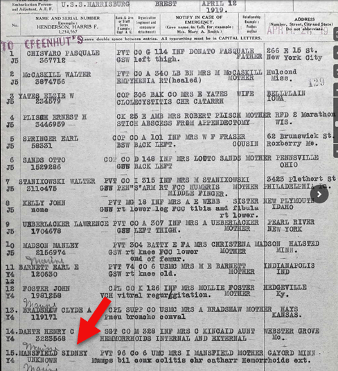
Record of Sidney F. Mansfield
Findmypast Granted Free Access to International Records Ahead of Veterans day 2019
The free access promotion ended at 12 pm GMT on Monday, November 11th
Findmypast includes more than 85 million military records covering the Armed Forces of the United States, Canada, Great Britain, Australia, New Zealand and Ireland. Researches can search for their ancestors in a variety of fascinating documents ranging from service records and pensions to medal rolls, POW records, casualty lists and more.
New Historical Records at MyHeritage
From the MyHeritage blog: “18.6 million new historical records have been added in October 2019 in seven new collections from all over the world, including:
- Australia,
- Spain,
- the former Soviet Union,
- Latvia,
- the United States,
- Germany,
- and Denmark.”
Here are the full details of these new record collections:
Australia Death Notices, 1860–2019
“This collection of over 7 million records contains death notices, funeral notices, and obituaries from Australia from a variety of sources. The dates of these notices primarily range from 1900–2019, with a few entries from the previous 50 years.”
Spain, Bilbao Diocese, Catholic Parish Records, 1501–1900
“This collection of over 4.9 million records consists of baptism, marriage, and death records for the Roman Catholic Diocese of Bilbao in Spain. The majority of the records correspond to the historical region of Biscay, Spain within the Basque Country, with a small minority of records from Cantabria.
Baptismal records contain the following searchable information: first name, primary surname and secondary surname of the child and parents, date, and location. For marriages: first name, primary surname and secondary surname of the bride and groom, date, and location. For death records: first name, primary surname and secondary surname of the deceased, date, and location. The parish is also listed in most records.”
Soviet Union, Soldier Memorials, 1915–1950
“The 4.5 million records in this collection provide details on soldiers from the Soviet Union who died or went missing during the wars in the early to mid-20th century.
Information listed on these records may include:
- name
- year of birth
- place of birth
- rank
- date of retirement
- place of retirement
These records might also include place of service, cause of death, and hospitalizations. Most of the information in this collection is in Russian. MyHeritage provides the ability to search this collection in one language and receive results in another using its unique Global Name Translation™ technology. The technology automatically translates given names and surnames into the language of the query. For example, a search for Alessandro (Alexander in Italian) will also find “Саша,” the Russian form of Sasha — a popular nickname for Alexander — with its corresponding translation into the language of your search.”
Latvia, Riga Internal Passport Holders Index, 1918–1940
“In the city of Riga during the interwar period, every person over the age of 15 was supposed to have an internal passport as proof of identity. This database of 890,811 records includes residents of Riga and may include the surname, given name, father’s name, date of birth, place of birth, and place of origin of the passport holder. This collection is completely free to search, view, and add to your family tree.
Many of the internal passport files contain all addresses the person lived at during the passport’s validity, including those outside of Riga.
Whenever the passport’s validity expired, the passport was to be returned to the government. It is not known how many actually returned their passport to the government, so this collection is not a complete representation of all people who lived in Riga during this period of time.”
United States Index of Gravestones, 1900–2018
“This collection includes 601,986 records from more than 25 cemeteries located in the United States.
The records include headstone inscriptions and burial records. In these records you may find information such as:
- deceased’s name
- date of birth
- date of death
- date of burial
- place of burial
Cemetery records are especially helpful for identifying ancestors who were not recorded in other records, such as children who died young or women.
Records from cemeteries in the following states can be found in this collection:
- California,
- Connecticut,
- Washington D.C.,
- Georgia,
- Illinois,
- Indiana,
- Massachusetts,
- Pennsylvania,
- Michigan,
- Ohio,
- Oregon,
- Rhode Island,
- and South Dakota.”
Germany, Emigrants from Southwestern Germany, 1736–1963
“This collection of 285,158 records is an index of emigrants leaving Southwestern Germany largely between 1736 and 1963. Records may contain the following searchable information: first and last name, birth date, date and county of emigration, and first and last name of a relative.
The following information may also be viewable:
- title
- alternate name
- former residence
- district
- address
- marital status
- religion
- occupation
- birth name
- destination
- additional information on the family of the individual.
Emigration from Germany occurred in a number of waves, triggered by current events such as the July Revolution of 1830, the 1848 March Revolution, the foundation of the German Reich in the 1870s, World War I, and other significant events. The majority of the records from this collection are from the mid 1750s to the early 1900s.”
Denmark, Copenhagen Burials, 1860–1912
“This collection of 255,733 records is an index to burial records from Copenhagen, Denmark.
Records typically list:
- the name of the deceased
- death date
- burial place.
In some cases, the deceased’s age, occupation, and cause of death may also be listed.
Burials usually took place with a few days of death. Burials in Denmark were recorded in the records of the parish where the burial occurred. Original burial records have been digitized and made searchable by the Copenhagen City Archives.”
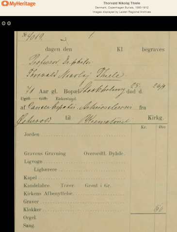
Sample: Thorvald Nikolaj Thiele Died: Sep 26 1910 Danish astronomer and director of the Copenhagen Observatory. He was also an actuary and mathematician.
Enjoy searching all of these new collections that are now available on MyHeritage SuperSearch™. Searching these records is always free, and you can also view and save records to your family tree from the Latvia, Riga Internal Passport Holders Index for free. To access Record Matches or to view or save records from the other collections, you’ll need a Data or Complete subscription.
MyHeritage’s Record Matching technology will notify you automatically if any of these records mention a member of your family tree. You’ll then be able to review the record and decide if you’d like to add the new information to your tree. Learn more about Record Matches on MyHeritage Education.
New Digitized Collections at the Library of Congress
From the Library of Congress: “Researchers and students have gained access to seven newly digitized collections of manuscript materials from the Library of Congress, including records of one of the most important women’s suffrage organizations, the papers of President Abraham Lincoln’s personal secretary and collections on the history of federal monetary policy. The availability of these collections added more than 465,000 images to the Library’s already vast online resources.”
The new collections include:
Women’s Suffrage:
The records of the National American Woman Suffrage Association:
records from one of the most important national women’s suffrage organizations in the U.S. The collection includes more than 26,000 items, most of which were digitized from 73 microfilm reels.
Civil War:
The papers of the presidential secretary and biographer John G. Nicolay (1832–1901) consist of 5,500 items scanned from original materials. Spanning the years 1811 to 1943, the collection particularly reflects Nicolay’s tenure as private secretary to President Abraham Lincoln.
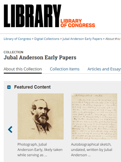
From the same era, the papers of Confederate general Jubal Anderson Early were also released online.
Massachusetts Business:
Olmsted Associates Landscape Architectural Firm – The collection documents the work of the landscape architectural firm originally founded by Frederick Law Olmsted as it was continued by his sons in Massachusetts. It includes nearly 150,000 items scanned from 532 reels of microfilm.
Federal Monetary Policy:
Three newly released collections relate to federal monetary policy:
- The Nelson W. Aldrich papers (documenting the National Monetary Commission, created in 1908)
- The Charles S. Hamlin papers (document the Federal Reserve Board during the first three decades of the 20th century.)
- The Eugene Meyer papers (document the Federal Reserve Board during the first three decades of the 20th century.)
Read the entire announcement at the Library of Congress.

