These show notes feature everything we cover in this episode. Premium Members: download this exclusive ad-free show notes cheat sheet PDF. Not a member yet? Learn more and join the Genealogy Gems and Elevenses with Lisa family here.
Are you worried about access to your online tree if you let your Ancestry.com subscription lapse? The tree should still be there. But take these steps to be sure your Ancestry family tree remains accessible and secure–along with the records you’ve attached to it.
Many people start researching their genealogy with an Ancestry subscription. They build their family tree on the web site, adding details about their relatives.
Then they sift through Ancestry’s billions of historical records and add hundreds or even thousands of new names, dates, relationships and other facts to their family trees. Along the way, they attach records to each ancestor as evidence of what they’ve learned.
All of this adds up to a unique family tree that is precious to your family.
However, it is very common for the busyness of life to call them away from their genealogy research for a while. This is what happened to Genealogy Gems reader Beverly. She wrote to me, concerned about what will happen to all her hard work on that Ancestry tree:
“I have been a member of Ancestry.com for a long time and have worked on several trees. I love to work on my genealogy but lately have not had time. Can I drop my membership and still retain my trees? I plan to get my membership back at a later day. Right now I am wasting $20 a month.”
Beverly, I hear your pain!
We all go through busy seasons. It’s easy to cringe at the thought of paying for genealogy website subscriptions we aren’t currently using.
But the idea of losing all our progress on those web sites if we let our subscription lapse is worse. Your Ancestry subscription has not only included your online family tree, but also all of the records that you found and attached to that tree.
I did a little research along with Sunny Morton, Genealogy Gems Editor and our resident expert on the “Genealogy Giants” websites” (Ancestry, FamilySearch, Findmypast and MyHeritage). Here’s what we can tell Beverly and everyone else who is wondering what will happen to their family tree and all that research if their Ancestry account expires:
According to Ancestry, the answer is yes, you can still access your trees with your login credentials after your subscription lapses. The most important thing is that you don’t delete the tree or the account altogether.
Ancestry continues to host people’s trees because they want our tree data to share with others, and to give people a reason to come back!
But be aware that if you do not renew your Ancestry subscription, your account will revert to a free guest account. (Your user name and password will remain the same.) This means that you will not be able to access most of Ancestry’s historical records, including the ones you’ve already attached to your trees. And I say “trees” because many people have multiple family trees on Ancestry to be concerned about.
To see the historical genealogy records that you have attached to an ancestor in your online tree, click on a person in your family tree, and then click Profile:
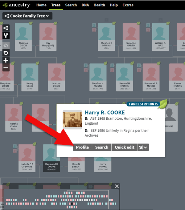
How to find genealogy records attached to a person in your Ancestry tree.
You will be taken to their profile page where you will see the genealogical sources you have attached.
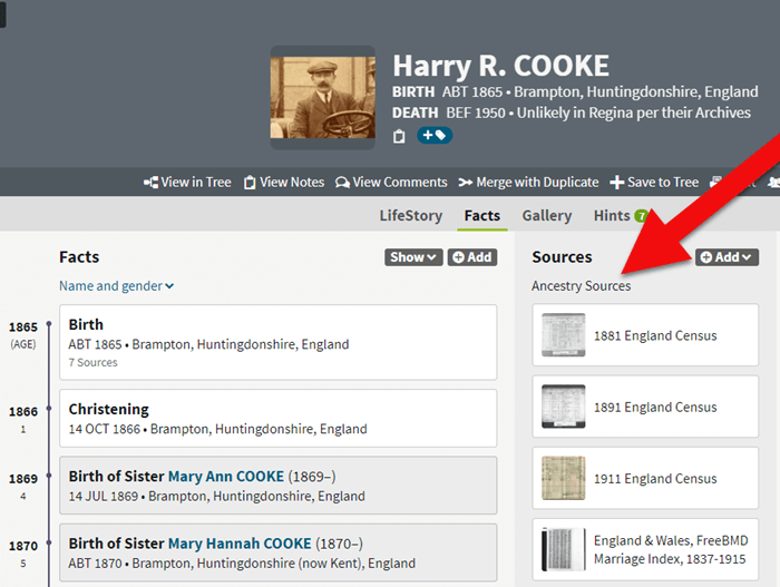
If your Ancestry account expires you can’t access records attached to your tree.
These are records that you will not be able to access when your subscription expires.
If you plan to let your Ancestry.com subscription lapse for a while, but you want to continue to work with your online trees, consider taking these steps:
The first thing to do is download a copy of every record that you’ve attached to your ancestors’ individual files on Ancestry.com.
You can do this by opening the image of the record, clicking on the Save/Saved button at the upper right, and clicking Save to your computer. I suggest doing this even if you don’t foresee letting your subscription go in the near future.
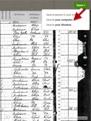
Saving a document to your computer from Ancestry before your subscription expires
I recommend using a consistent system to organize these, which I explain in the free Family History: Genealogy Made Easy podcast, in episodes 32-33. (Genealogy Gems Premium website members have access to a 2-part video tutorial on organizing their hard drives.)
If you don’t have a consistent way to organize these document images, you’ll soon become overwhelmed with files that all sort of look the same and you won’t be sure what year they are or which ancestors they pertain to without opening each one!
You may be wondering “What about cloud storage options, such as Google Drive or Dropbox?” These type of cloud storage solutions are ok too. However, I recommend using these platforms more as temporary or backup storage or to share with relatives, rather than as your primary storage.
A better alternative would be to invest in cloud-based backup for your home computer. I use Backblaze personally and for my business.

Click here for instructions; it’s really easy.
Yes, Ancestry does continue to maintain your trees, but what guarantees do you have?
Data loss does happen even on big websites, and sites change their practices and policies sometimes. If that happens, you could lose all the information you’ve carefully added to your tree.
Don’t just keep your family tree online where you don’t have complete control.
A “master family tree” is your most complete, up-to-date version of your tree (or trees, if you build separate ones for separate family lines).
Keeping your master tree on your own computer keeps all your tree data at your fingertips without any subscription required. Having one master file matters even more once you start sharing your tree on other websites or with relatives.
I use RootsMagic, and that is why I happily agreed to them sponsoring my Genealogy Gems Podcast. It works for Mac and the PC.
![]()
I like its affordability: there’s a free version you can try for as long as you like, and the full software will cost you the same as about 90 days of access to Ancestry.com.
RootsMagic also has solid relationships with the major genealogy sites: it now syncs with your trees on Ancestry.com and FamilySearch.org, and you can research records on MyHeritage.com and Findmypast.com.
RootsMagic has tons of advanced features to help you create family history charts, books, and reports, and a great user support community online.
Keep up with news and changes on the “genealogy giants” websites with our ongoing coverage of Ancestry.com, FamilySearch.org, Findmypast.com, and MyHeritage.com here.
Disclosure: this post recommends carefully-chosen products and services for which we receive compensation. Click here to read my full disclosure statement, and thank you for supporting the free content we provide at Genealogy Gems.
A recent blog post at slate.com caught my eye because it features a map from the genealogists-love-it David Rumsey map collection. But what captured my attention was the story the unfolded behind the foldable map itself. I think you’ll love it!
Blogger Rebecca Onion uses a 1929 souvenir map of the United States to tell the story of early commercial air traffic–specifically the story of the origins

Rumsey TAT map
of airline giant TWA. Apparently early “transcontinental flights,” as they were advertised, were sight-seeing tours with short flights interspersed by train rides to the next flight location. The map featured in her blog post was a souvenir of one of these passengers, who added his own colorful comments on his experience.
This fun post is part aviation history, part map-lover trivia. The story unfolds even more in a short video documentary on Transcontinental Air Transport I’ve added below. It includes cool aerial shots and more on how the early air transport industry, er, got off the ground.
And don’t forget to use maps (storied or just the plain informational types) in your family history research! These can help you find your way around ancestral hometowns, chart migration routes as they would have and otherwise see the world (literally) in the same ways they did. David Rumsey’s map collection is one of the best online collections out there, with free access to over 44,000 high-resolution historical maps.
Learn more about how to use the David Rumsey historic map collection in conjunction with Google Earth by watching my free video class Google Earth for Genealogy.
My Genealogist’s Google Toolbox Kit, is a value bundle that includes my book The Genealogist’s Google Toolbox and Volumes I and II of Google Earth for Genealogy (on video CD). And right now the kit is available for 20% off!
Genealogy Gems Podcast
Episode #192
with Lisa Louise Cooke
 Highlights from this episode:
NEWS: Dropbox Improvement
New on Dropbox: Now when you share Dropbox content with someone, shared links will stay active even if you move or rename the file or folder.
Dropbox file-sharing tip: “If you ever want to unshare something you’ve already sent out (like to remove access to a sensitive document), it’s easy to disable an active link.” Just sign in to dropbox.com. “Click the link icon next to the file or folder, and click ‘remove link’ in the top right corner of the box that appears. You can also remove the link by visiting dropbox.com/links and clicking ‘x’ next to the file or folder.”
How to share folders on Dropbox
NEWS: MyHeritage and Tribal Quest
NEWS: New Premium Video
 Getting Started in Genetic Genealogy: a new video available to Genealogy Gems Premium website members by Your DNA Guide Diahan Southard
Genealogy Gems Premium website membership: Click here to learn more
Click here to watch a free video preview
MAILBOX: Russ Recommends the U.S. Public Records Index
 Russ blogs at https://worthy2be.wordpress.com/
Genealogy Gems Podcast episode 181: What to use while waiting for the 1950 census
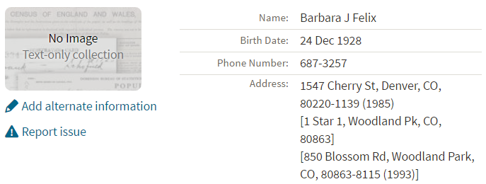
Russ recommends the “U.S., Public Record Index, 1950-1993, Volume 1 and 2.”
“Volume 1 is far more interesting with more data. A search will return a Name AND Birth date, along with more than one ADDRESS, Zip Code and sometimes phone numbers.”
Ancestry’s description of its online database for Volume 1 says original data comes from public records spanning all 50 states, such as voter registration lists, public record filings, historical residential records and other household database listings.
Thoughts about using the U.S. Public Records Index (some of these points come from the FamilySearch wiki):
Not everyone who lived in the U.S. appears in the index, and you’re more likely to find birth information for those born between 1900 and 1990. What you’ll find is primarily where someone lived, and often when they lived there.
It’s rarely possible to positively identify a relative in this index, since there’s limited information and it spans the entire country for up to a half century, and you can’t follow up on the record it comes from because the index doesn’t say where individual records come from. As Russ says, this is a great resource to use in combination with other records. It’s a similar concept to the way you might consult uncited family trees: great hints to go on and follow up with further research into verifiable sources.
When you find more recent listings, you can sometimes find telephone numbers for living distant relatives. The Family History Made Easy podcast has a 2-episode series (episodes 14 and 15) about cold-calling techniques for reaching out to distant relatives you don’t know.
MAILBOX: Katie on Cold-calling and Adoption and DNA
Katie blogs her family history adventures at McKinnon Ancestry.
Click here to read a blog post with her story and see more pictures that go with it.

INTERVIEW: Amie Tennant
 Amie Tennant is the newest member of the Genealogy Gems team. She contributes to the blog at www.genealogygems.com. She is also preparing to become a certified genealogist, which is a professional credential offered by the Board for Certification of Genealogists (BCG).
What have you learned in the process of preparing for certification?
“I think the biggest thing I have learned is the meaning of true exhaustive research. We talk a lot about that in our genealogy standards, but essentially, it is looking EVERYWHERE for EVERYTHING that might shed light on your research question.”
Why do you want to become certified?
I want a way to determine how well I am doing. A measuring stick of sorts.
What is the process like?
The process is the same for everyone. Once you have decided to become certified, you apply to the BCG. They send you a packet of information and you are “on the clock.” The clock is up in one year unless you ask for an extension. The portfolio you create consists of:
GEM: How to Create Family History Videos Quickly and Easily
Visit our page on how to create family history videos which includes video tutorials and inspirational examples.
![]() BOOK CLUB: Interview excerpt with Helen Simonson,
BOOK CLUB: Interview excerpt with Helen Simonson,
author of
The Summer Before the War


Beatrice Nash is a bright, cosmopolitan young lady who has grown up traveling the world with her father. Now he’s gone, and she’s landed in the small village of East Sussex, England, where the locals aren’t entirely thrilled about engaging her as a female Latin instructor for their schoolchildren. She spends a summer fighting for her job, meeting a local cast of engaging eccentric characters (both gentry and gypsy) and trying not to fall for handsome Hugh. Then the Great War breaks out.
This novel follows Helen’s popular debut novel, Major Pettigrew’s Last Stand, which became a New York Times bestseller and has been translated into 21 languages. Genealogy Gems Premium website members can join us in June to hear our exclusive and fun interview with Helen Simonson.
GENEALOGY GEMS PODCAST PRODUCTION CREDITS:
Lisa Louise Cooke, Host and Producer
Sunny Morton, Contributing Editor
Vienna Thomas, Audio Editor
Additional content by Lacey Cooke, Amie Tennant
Disclosure: This article contains affiliate links and Genealogy Gems will be compensated if you make a purchase after clicking on these links (at no additional cost to you). Thank you for supporting Genealogy Gems!
The places where your ancestors lived can tell you a lot about their lives. I’m going to show you a free and easy technique for plotting land in Google Earth.
episode 67
Would you like to be able to find your ancestor’s property on a map today? Keep reading and watch the video to learn how. We’re going to take U.S. government survey legal land descriptions found in sources such as Federal Land Patents and quickly and easily plot the boundaries in Google Earth Pro. I’ll also show you an easy way to do it for property in Canada too.
(PREMIUM MEMBERS: Get your ad-free PDF cheat sheet for this episode in the Resources section at the bottom of this page. Not a member yet? Click here to join the Genealogy Gems family and get all the benefits.)
In the video I show you how to plot the boundaries of a piece of land in Google Earth. We’re going to take U.S. government survey legal land descriptions found in sources such as Federal Land Patents and quickly and easily plot the boundaries in Google Earth Pro. I’ll also show you an easy way to do it for property in Canada too. These strategies come from my book The Genealogist’s Google Toolbox,
These days there are actually three versions of Google Earth:
All are free, but they are not the same. The app and web browser versions are sort of “Google Earth lite.” The software is what you want because it has all the bells and whistles that will allow you to do all the things I’m going to show you today.
Plotting legal land descriptions in Google Earth has its advantages. If you’re plotting the land of your ancestors, you’ll be able to see what the area looks like today and what the current street names are. In Google Earth you’ll also have access to additional tools that you can use in conjunction with the boundaries you’re going to create, such as historic maps, area photos, and a wide range of data sets that provide more information about the area.
The first thing to do is check to make sure you have the most current version of Google Earth on your computer. Again, we’re using the software so you need to do this on your desktop or laptop computer. You want to make sure you have Google Earth Pro – LINK – A tell tale sign that you don’t is if the Google Earth globe icon on your desktop is grey and not blue. Open it and in the menu go to Help > About Google Earth. Here it should say Google Earth Pro and you can see the version number.
Check the current version number here, and if you don’t already have the program, go ahead and download it.
Now that you have it on your computer, open it up and leave it running in the background. You’ll need a decent internet connection for it to run.
Next pull up the legal land description that you want to plot. Here’s one that I have for some property owned by George Burket. I found this at the Bureau of Land Management Government Land Office Records website. This free website is where you can search for land patent that your ancestors once held.
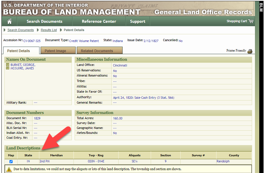
Legal land description at GLO
Even though the Bureau of Land Management places it on the map on their website, you can’t download this or add to it. The advantage of plotting this in Google Earth is that you will have access to much more geographic data, you can add many more details to the map, you can use it in conjunction with other related mapping work that you’re doing, and you can save and share it.
This description gives us the exact coordinates of the property. Jot down the land description or keep it open in your browser tab so you can refer to it.
In a new browser tab, we’re going to type in http://www.earthpoint.us. This will take us to the Earth Point website.
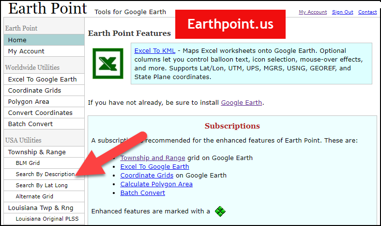
Search by legal land description at Earth Point
This website is free, although some of the features are available only with a paid subscription. Thankfully, the tool for plotting your ancestor’s land patent is free. Some of the free features do require that you sign up for a free account. The feature we are going to use currently does not.
On the Township and Range – Search by Description page you will see a field for each piece of information found in the land description. It’s important to enter this information in the order presented starting with the State. Select the state from the drop-down menu. Pause a moment to allow the fields to recalculate. This allows the appropriate data to be loaded into the next field based on your selection.
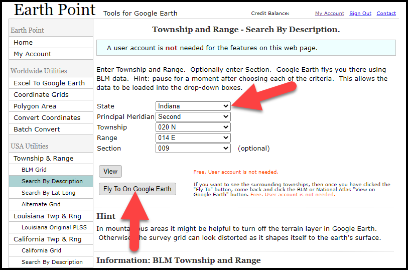
Entering data at Earth Point
After you have made each selection, click the Fly to on Google Earth button. This will generate a KML file which can be saved to your computer. KML stands for Keyhole Markup Language, which is the file type that Google Earth uses and understands. KMZ are zipped KML files which also are used by Google Earth.
Save the file to the desired location on your hard drive. Then click the file to open it. It will automatically open in Google Earth (which you already have open). The KML file is now located in your Temporary Places folder in the Places panel. The land is has now been automatically plotted on the map.
The orange outline is the township. In this example it is township T20N R14E. Click the orange ball in the center of the township for details. In the details you’ll find the total number of acres in the township, the latitude and longitude coordinates for the center of the township and corners.
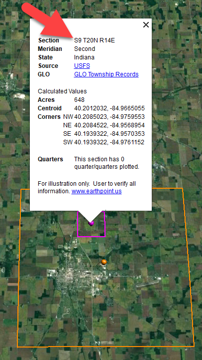
Township in Google Earth
The pink / magenta outline is the Section where the property is. Click the pink center dot for the details:
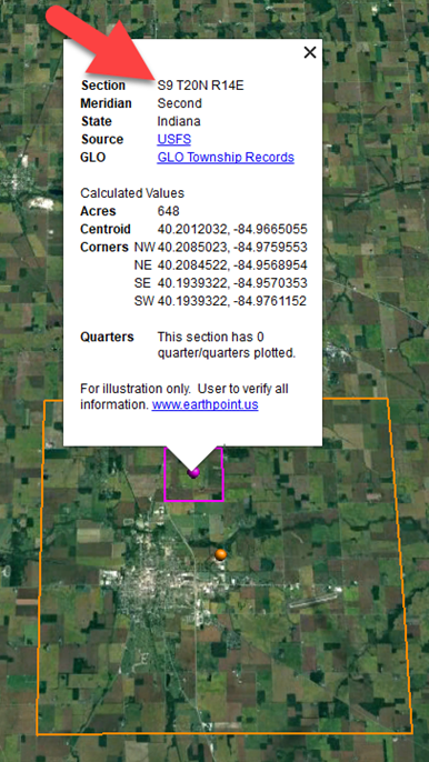
Land section in Google Earth
In this example Section 9 consists of 648 acres.
Notice that Earth Point was able to plot the land down to the Section level. However George Burket did not own the entire section. We must return to the land description for the Aliquots.
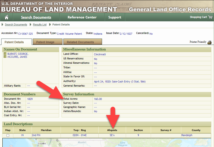
Aliquots in Legal Land Description
In this example, the land was the southeast quarter (SE1/4) of section 9. The land was a total of 160 acres.
We can use the Polygon tool in Google Earth to plot the 160 acres. In the toolbar, click the Polygon tool. This will open the New Polygon dialog box. Type a title, description and source citation.
As you hover your mouse over the map you will notice that the cursor is now a square shape. Click the screen on each of the four corners one at a time in order to set the four corners of the property – in this case the southeast quarter of the section. Once you have drawn the shape you can click on the handle on any corner to adjust precisely.
Click the Style / Color tab in the New Polygon dialog box to adjust the color and opacity of the acreage polygon. You can add color and thickness to the outline, and color and opacity to the fill of the shape. When you have it set the way you want it, click OK to close the New Polygon box. The Polygon is now set.
On the left side of the Google Earth screen you will see a series of panels: Search, Places and Layers. At the bottom of the Places panel is the Temporary folder. This is where the KML file was placed when it was opened. However, like its name implies, this is a temporary location. If you want to keep it, you’ll need to move it to a filed location within the Places panel. This will not change the position of the polygon on the map, only where it is filed and saved in the Places panel.
To file a polygon, click on the file in the Places panel, drag it to the desired location, and drop it. Next, go the main menu and click File > Save My Places. This will save your work so that when you close the program it will not be lost. Google Earth doesn’t auto-save.
The polygon plotting the acreage will be visible on the map when the box is checked in the Places panel. If you uncheck the box for the polygon it will still be there, but it will not be visible on the map. This allows you to create and save many items of interest without always having to have them displayed and cluttering up the map in Google Earth.
After your land polygon has been set, you may want to rename it. There are two ways to do this:
You can also restyle the polygon and edit the text. Start by going to the Places panel and click the arrow pointing at the Polygon’s globe icon. This will open it and show the nested content. Click to select the Polygon. Now you can right-click it (PC) and select Properties – OR – go to the menu under Edit > Properties. Either way it will reopen the Polygon dialog box so that you can make the desired changes. When you’re done, click the OK button to close the Polygon.
Snagit is the tool I used to capture the various views of the land I plotted in Google Earth. Learn more about Snag it by watching my videos and reading the show notes for episode 61 (for beginners) and episode 66 (advanced).
Although the Earth Point website doesn’t plot Canadian land, the Legal Land Description Converter website does. It can help you find land in Western Canada (British Columbia, Alberta, Saskatchewan & Manitoba) subdivided by the Dominion Land Survey (DLS) and the Alberta Township System (ATS).
These show notes feature everything we cover in this episode. Premium Members: download this exclusive ad-free show notes cheat sheet PDF. Not a member yet? Learn more and join the Genealogy Gems and Elevenses with Lisa family here.
Gwynn: I would like to know how to match plat with GPS coordinate/ current street address.
Answer: I cover how to overlay a plat map in Google Earth and discover the current street address in my book The Genealogist’s Google Toolbox.
Roger D: How exact do you need to be in picking points? Does Google snap to mid-points of lines?
Answer: Try to be as exact as you can, however as I showed in the video you can reposition them as needed. Google Earth doesn’t snap.
Lyn: Can I do this with English tithe maps?
Answer: There isn’t a website converter that I know of. However I do cover how to overlay digitized maps in Google Earth in my book The Genealogist’s Google Toolbox.
The manufacturer price is going up August 31, 2021. Now’s the perfect time to get your official Elevenses with Lisa mug.
You can also find them through the menu: Premium > Premium Videos > Elevenses with Lisa.