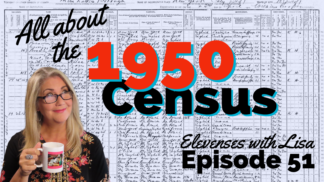
In Elevenses with Lisa episode 79 Lisa Louise Cooke explains:
How to find 1950 US Census Enumeration District (ED) Maps
The purpose behind them and how to interpret the maps
Ways to use the maps for your genealogy
This is a follow up to episode 51 on The 1950 Census for Genealogy. In that episode I discussed the importance of finding your ancestors’ enumeration district numbers in order to be able to find them when the digitized images are released (before the index is available.) In this episode I will walk you through how to locate the enumeration district (ED) number and then find the actual 1950 US Census ED map. We’ll wrap things up with a quick update on the release of the 1950 US Federal Census.
Episode 79 Show Notes
(Get your ad-free Show Notes Cheat Sheet at the bottom of this page in the Resources section.)
As I mentioned in Elevenses with Lisa episode 51 The 1950 Census for Genealogy, prior to 1880, U.S. Marshalls were the enumerators for the federal decennial census. Starting with the 1880 census enumerators were hired and they were each assigned an enumeration district, also known as an ED. These districts had to be mapped out so that the enumerators knew the area they were responsible for counting. Therefore, maps are drawn in anticipation of each census being taken, including the 1950 census.
Learn more by watching episode 51 on the 1950 census.
About the 1950 US Census Maps
It’s always important to understand the purpose of a record or source, and the 1950 Enumeration District maps (ED maps) are no exception. Unlike most maps where it’s all about accurately drawing up the current roads and geographical features, census ED maps are drawn up for the purpose of defining boundaries for the purpose of counting people. This means as we look at ED maps we need to keep a few things in mind.
The first thing to understand is that the 1950 ED maps were not necessarily up-to-date with the lay of the land in 1950. Not all streets, parks and features will be included. The reason for this is that the maps themselves were not created for this purpose. Existing maps were used and then enumeration district boundaries were drawn on them.
Maps came from a variety of sources including but not limited to county and City Planning Commissions, 1940 census bureau tract maps, and city engineers. In fact, from a mapping perspective the variety of maps in the collection are fascinating.
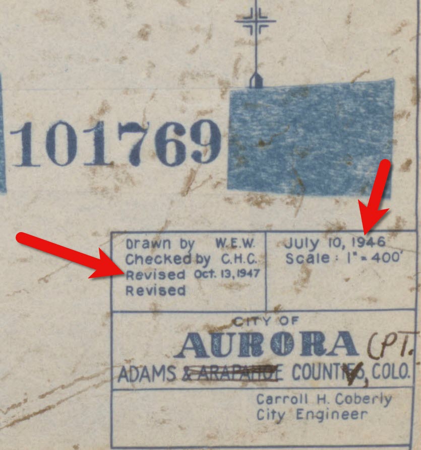
Look for the map title, description, legend and census stamps typically found in one of the corners. In this example (see image) from Aurora, Colorado the map used was originally created by the city engineer in 1946 and was revised in 1947.
1950 census map of Aurora, Colorado (Source: National Archives)
Following the end of World War II, the United States was growing at a quick pace in 1950. This is particularly true of the newly emerging suburbs. Therefore, if your ancestors built a new home in a new development in 1949, don’t be surprised if you don’t see the street on the 1950 census ED map. However, rest assured that the maps still hold value for your family history as they provide many interesting and unique details about the area surrounding your ancestors’ homes.
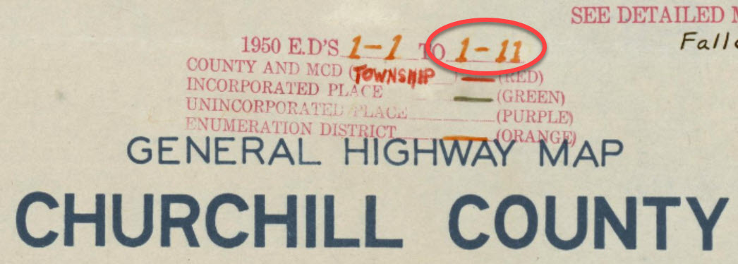
Each map was stamped with a small legend where the meaning for each of the colored lines drawn could be indicated. From my random sampling of 1950 census maps across the United States it appears that the coloring coding was consistent as follows:
Red = Township
Green = Corporate Limits/Ward
Orange = Enumeration District
Expect to see errors, inconsistencies and omissions in the maps. The more rural the area the more likely the map was compiled from several sources by the Census Bureau cartographers. This compilation created more opportunity for errors, and often used older maps.
Source: National Archives
The Meaning of Census Enumeration District Numbers
A census enumeration district number is made up of two numbers separated by a dash. The first number (in this example: 1) represents the county/region. The second number represents the area within the county that could be covered by an individual census enumerator within the amount of time provided for taking the census, about 2-4 weeks. The official start of the 1950 US Federal Census was April 1, 1950.
Census enumeration district (ED) numbers on a 1950 census map.
How to Find 1950 Census Maps
Some 8,000 census maps have been digitized and are available at the National Archives. However, the National Archives website can be challenging to navigate. I recommend using the Unified 1880-1950 Census ED Finder Tool at Steve Morse’s website.
1. Go to https:/stevemorse.org
2. In the menu in the upper left corner hover over US Census and in the secondary menu click Unified 1880-1950 Census ED Finder
3. Select the state from the first drop-down menu.
4. Next select the county.
5. Then select the city.
6. You will then see many enumeration district links listed. In order to find the right one for your ancestor’s home, enter the house number and select the street from the next drop-down menu. Don’t worry about directional parts of the address like west or east unless they are offered in the list of street names.
7. As soon as select the street name, the list of ED numbers should be reduced. In this example we are down to three.
8. To further reduce the possible ED numbers, we can select Cross or back street on same city block. If you’re not sure what the neighboring streets are, click the see Google Map This will plot the address you entered into Google Maps where you can then find the closest cross street, and the next streets over. If the address is not precisely marked on the map, check the address that appears in the Google Maps search box.
In my case, the One-Step tool didn’t allow me to specific W. Arcade, so Google Maps just gave me the general area, and not the address. By adding the W. to the address and pressing enter on my keyboard Google Maps was able to precisely plot the location. Now we can make note of the closest cross street (ex. N. Center), the street north of the address (E. Monterey Ave.) and the street south of the address (W. Noble St.)
9. Head back to the Unified 1880-1950 Census ED Finder page and enter each nearby street (you can enter multiple.) This should reduce the ED numbers one. This is the ED that includes your ancestor’s address.
How to Find 1950 Census Maps
1. Make note of the ED number, and then go back and click the button that says See ED Maps for ____________ County. You could have clicked this button without going through the process of locating the ED number, but the ED number makes it much easier to find your ancestor’s home street on the map. This number will also assist you in being able to find your ancestors in the 1950 census before it is indexed.
2. You will now be on the Viewing 1950 Enumeration District Maps in One Step Re-enter the city from the drop-down menu.
3. Click the Get ED Map Images You will receive two links. The first link is Links to NARA viewer will take you to the page on the National Archives website which includes all of the information about the map and the record hierarchy. Source citation information can be gathered from this page.
5. Click the second link called Direct links to jpegs on NARA server. This will take you to the image by itself as hosted on the National Archives website. I find this the easiest way to save the full resolution image to my computer hard drive. On my PC I right-click on the map and select Save Image As.
This page is also important if you want to use this image in another program such as Google Earth. The URL for this page is the direct URL to the image. Notice that it ends in .jpg. This means that it is the image alone, and this link can be used to create a custom map overlay in Google Earth. You can see an example of a custom map overlay in my video Create a Family History Tour with Google Earth Pro at the 06:13 mark.
The Genealogy Gems Podcast
Episode #205
with Lisa Louise Cooke
This episode breaks two huge pieces of genealogy news and shares two great conversations:
FamilySearch ends microfilm lending: how you can get the records you need;
RootsMagic adds Ancestry.com compatibility: sync your Ancestry.com tree to your master RootsMagic file and search Ancestry.com from within the software;
Melissa Barker, the Archive Lady, talks about visiting archives to explore original manuscript record treasures;
Nicole Dyer shares a fun family history activity idea to do with kids?do you have a family gathering coming up that could use this inspiration?
Lisa Louise Cooke shows you how to use the free Google Earth Pro software to create your own historic map collection customized for your genealogy and family history research. By the end of this class you’ll have a permanent collection of hundreds of gorgeous historic and vintage maps from around the world, organized and ready to use for family history.
Click here to watch a free preview of this full-length video class. Genealogy Gems Premium website members can watch the whole thing: click here to learn more.
The 4th Annual Northwest Genealogy Conference
This episode today is brought to you by the 4rd Annual Northwest Genealogy Conference, hosted by the Stillaguamish Valley Genealogical Society, north of Seattle in Arlington, WA. Centering on the theme, “Where Does Your Story Begin?” it’s four days PACKED full of genealogy.
There will be well-known and respected keynote speakers, including our friend and genetic genealogist Diahan Southard, speaking on DNA; Kenyatta Berry of Genealogy Roadshow fame, speaking on Caribbean research and using slave schedules in research; and Daniel Earl speaking on Putting History in Your Family History.
Starting off with the Free Day Wednesday afternoon, Speaker Peggy Lauritzen will address beginner’s issues in her Genealogy 101 presentation, which is also a good refresher for the more seasoned genealogists. There will be such great genealogical information for all levels, AND it’ll be lot of fun!
Between classes take a chance to meet a distant cousin with the “Cousin Wall”. Participate in the genealogy-related scavenger hunt, the Wednesday evening meet and greet and the Friday dress-as-your-ancestor day, and much, much more!
Go to www.NwGC.org for details and to register. Check it out now — registrations are limited, so it’s good to get in early. It’s August 16-19, 2017. It’ll be a great show: don’t miss it!
Items in danger include original items in attics, basements, etc.
What to preserve first? The most precious and original items you have!
Restoration tips:
Clean documents and photos with archival sponges. Lay the item perfectly flat. Gently place a finger or hand to hold it steady. Work with the sponge from the center outward, in small sections.
Keep two-dimensional items as flat as possible.
Encase fragile items in Mylar sleeves (buy from archival supply companies).
Image courtesy of Melissa Barker and Houston County, TN Archives.
Visiting an archive:
Call ahead! Don’t trust the operational hours from the website. Ask about parking ? it’s often very limited. Ask ahead about access to archival items of interest.
Archive etiquette: Follow the rules. Be courteous when working with staff.
Museums, societies, archives, and libraries may all have collections in back rooms you can’t see?but you can ask for them.
Vertical Files – in folders in cabinets
Manuscript Collections – underused in genealogy! Ask for finding aid.
Loose Records – the working papers of a court case, for example
Unprocessed Records – not yet incorporated into the official collection
Tips for using your mobile devices in archives:
Ask for procedures for taking photos with your own device. There may be rules against this or a use fee.
Capture the source information by photographs: cover page, page number, folder, box number, manuscript collection name, etc.
If you’re listening through the Genealogy Gems app, your bonus audio content for this episode comes from Melissa Barker, the Archive Lady, with more about finding and using original manuscript records in your genealogy research. The Genealogy Gems app is FREE in Google Play and is only $2.99 for Windows, iPhone and iPad users.
Lisa Louise Cooke uses and recommends RootsMagic family history software. From within RootsMagic, you can search historical records on FamilySearch.org, Findmypast.com and MyHeritage.com. RootsMagic is now fully integrated with Ancestry.com, too: you can sync your RootsMagic trees with your Ancestry.com trees and search records on the site.
Keep your family history research, photos, tree software files, videos and all other computer files safely backed up with Backblaze, the official cloud-based computer backup system for Lisa Louise Cooke’s Genealogy Gems. Learn more at http://www.backblaze.com/lisa.
INTERVIEW: NICOLE DYER
Nicole has been researching her ancestors and delighting in their stories for the past 15 years. Nicole volunteers at the Tucson Family History Center teaching a family history story time group for young children.
(Full disclosure: this podcast blog contains affiliate links. We will be compensated if you make a purchase through our link. Isn’t that an awesome way to help keep the free podcast free?!)
Start creating fabulous, irresistible videos about your family history with Animoto.com. You don’t need special video-editing skills: just drag and drop your photos and videos, pick a layout and music, add a little text and voila! You’ve got an awesome video! Try this out for yourself at Animoto.com.
GENEALOGY GEMS BOOK CLUB: A FAMILY HISTORY MURDER MYSTERY!
Some Ancestry.com collections are super valuable but, for one reason or another, are easy to miss. You DON’T want to miss these four exclusive Ancestry.com collections that were hand-picked by an Ancestry staffer: landowner maps, iconic shopping catalog images,...
Premium Podcast Episodes As a Genealogy Gems Premium Member you have access to the entire back catalog of Premium Episodes! Of course, things do change over time, so occasionally you’ll hear about something that is no longer around (like the Premium Message...
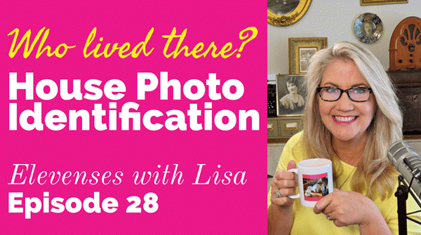
Original air date: 10/8/20 Join me for Elevenses with Lisa, the online video series where we take a break, visit and learn about genealogy and family history.
In this episode we’re going to take many of the things we’ve learned in past episode of Elevenses with Lisa and apply them to one of your genealogical problems. My goal isn’t to find the answer myself, but rather to provide a toolbox of strategies that you can use to experience the joy of the discovery yourself when researching a home or location, as well as in a wide variety of other genealogical situations! Keep reading for notes that accompany this episode.
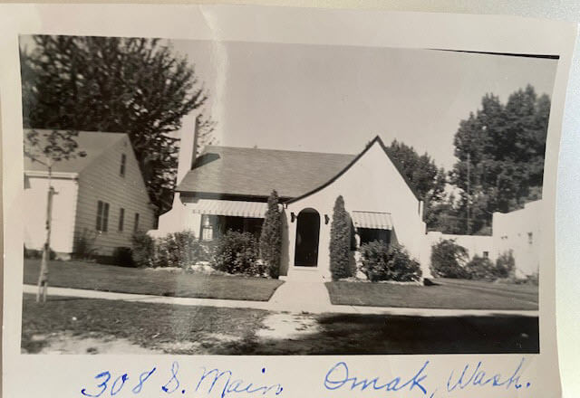
Cynthia Owens is a regular viewer and participant in the Live chat each week during Elevenses with Lisa. She emailed this photo and wrote “This picture was with my mother’s belongings…photo of a house in Omak, Okanogan, Washington with only an address written on it. 308 S. Main, Omak, WA. I have hundreds of photo’s (B & W) that have no information on them and a lot of people who I don’t know. I have a gold mine and no idea how to mine it.”
The house photo in Cynthia’s family collection.
Cynthia said that so far she has found the names of the last two owners in county records and some directories. She also determined that the house was built in 1928. She writes, “I have a lot of family on both sides of my parents who could have owned it.”
Formulate Your Research Question
The research question in this case boils down to: Who owned the home at 308 S. Main, Omak, WA in the 1930s?
Compile Known Family Names
We start by compiling a list of family surnames that we will be on the lookout for. These are families who are known to have lived in Washington state during that time frame.
Cynthia’s mother’s family names:
Woodhead
Patience
Cynthia’s father’s family names:
Tucker
Stubbs
Tonks
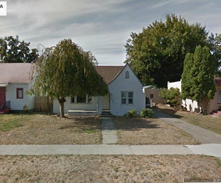
Answer the Question Does the house still exist today?
To answer this question, we turn to the free Google Earth Pro software. By simply searching the for the address and using Street View we are able to determine that yes, it is. Google Earth also allows us to obtain a high-quality image.
The house in Google Earth’s Street View today.
Google for Land Records
I conducted a simple Google search: Okanogan County Land Records
The results:
The Central Regional Branch of the Washington State Archives
“The Central Regional Branch provides archival and records management services to local government agencies throughout Benton, Chelan, Douglas, Franklin, Grant, Kittitas, Klickitat, Okanogan, and Yakima counties.”
Special Guest: Kathy Nielsen, Librarian Kathy Nielsen is a reference librarian and an educator. She has a masters degree in History and in Library Science. Kathy is currently a popular genealogy speaker on California’s Monterey Peninsula. She incorporates her skills as an historian, a storyteller and a librarian in her search for her family’s history. Kathy Nielsen stopped by to offer suggestions on obtaining land records. Watch Elevenses with Lisa episode 20 on House History featuring Kathy Nielsen.
The FamilySearch Wiki
Visit the free FamilySearch Wiki here. Search for the county in the wiki and then click on Land Records.
County Auditors Department
Where land records are located.
You can do a title search.
The records may not be online.
Email or call and inquire what the options are to access the records or have a search done.
Access varies by county.
Follow the chain of ownership back in time:
Grantee = the person who bought the property
Grantor = the person who sold the property.
Real Estate Websites
Trulia.com
Zillow.com
These sites don’t provide owner names but do show you recent transactions.
Result: The house was sold in 1997. It went on the market briefly in 2013.
Assessor’s Office (Tax Records)
These are typically only available to the current owner.
More Places to Look for Real Estate Related Information
City Directories
City directories are usually published yearly. Look also for Reverse Directories that allow you to look up the address in order to find who lived there. Kathy suggests contacting the local public library staff to inquire about City Directories and other records. Many libraries are currently staffing online reference chat.
State Libraries
Kathy recommends expanding out from the local area library to nearby communities, and the state. The Washington State Library is also currently answering questions. They have a genealogy department and city directories.
WorldCat.org
WorldCat is the world’s largest network of library content and services. The online catalog that itemizes the collections of 17,900 libraries in 123 countries and territories.
National Register of Historic Places
According to the website: “The National Register of Historic Places is the official list of the Nation’s historic places worthy of preservation. Authorized by the National Historic Preservation Act of 1966, the National Park Service’s National Register of Historic Places is part of a national program to coordinate and support public and private efforts to identify, evaluate, and protect America’s historic and archeological resource.” Click here to learn more about and search their digital database.
Department of Archaeology and Historic Preservation (Washington State)
From the website: “On this site you will find information on historic buildings, the archaeology of Washington State, how to navigate our regulatory processes and how to nominate properties to the State and National Register of Historic Places.”
Neighbors
Contacting and talking to neighbors is often one of the quickest and easiest ways to gain information. The 411.com website offers a free reverse address lookup. The results will give you the name of the current owner and residents, and even plot nearby neighbors (with names) on a map.
Researching the Home from Home
If you’re unable to research in person, make significant headway with these online resources.
Historical Societies
Google to find the official website of the historical society located in the area where the house is located. These sites may include searchable databases and information on how to contact them for resources and lookups.
Result: The Okanogan County Historical Society features a searchable database.
Facebook
Search Facebook for the name of the county historical society in the area where the house is located. Facebook pages often include more up to date information than the official website.
Old Maps
Depending on the town and area, you may be able to find an old map from the approximate time frame that includes details on homes. Two excellent free resources are:
Davidrumsey.com
Historical maps in the Layers panel of Google Earth Pro
Search at Genealogy Records Websites
Searching for various combinations of the address, town and surnames from the family tree may lead you to an answer. Here are a few examples of searches run at Ancestry.com and FamilySearch. (Your results may vary depending on the date you are searching):
Keyword: (address) 308 Main St, Omak (exact)
Results: 25 (These were not all exact)
Residence: (town) Omak (exact) and Keyword: (address) 308 Main St. (exact)
Results: 5
Search each surname in Okanogan County at Ancestry.
Results for Cynthia’s mother’s family names:
Woodhead (Paul Woodhead married in Okanogan in 1941)
Patience (No results)
Cynthia’s father’s family names:
Stubbs (results from the 1970s)
Tonks (None)
Tucker (8 results)
FamilySearch.org
Run the same at the free FamilySearch.org genealogy website. Search each surname with Omak (exact) & 1920-1940 (restricted to) U.S. On the day I searched, the only surname from the list with results was Tucker. Cynthia’s next step would be to compare the results to her known family tree.
Search the Census Specifically
You can search the census by using the search fields and using variations of names, town, county and specific address. If you don’t find the specific address that way, brown the records of the town, looking for addresses written in the left margin. At Ancestry, look for the link to a map of the location found in a census.
Results: 1930 Census: 104 West First St., Omak (Jess Tucker)
Use Google Earth to determine if the addresses found are the same today. Plot each finding on the map using placemarks.
Result: 1930 Census Address: 104 West First Street, Omak = not there today
A search in the 1940 for Jess Tucker found him still living with his mother. She was recorded as “Frances Write” living at 504 Main St., Omak, close to the house in question. When searching the census be sure to look at the pages on either side of the results page. In this case Jess is found on the next page living at “no number” as a renter at his mother’s home.
1940 Census Enumeration District Maps
Ancestry has a collection of 1940 Enumeration District Maps from the National Archives (where they can also be found here along with additional helpful search strategies.) Enumeration districts are geographic areas that were designed to allow an enumerator (the census taker) to visit every house in the district within a two-week time period. A month was allowed in more wide-spread rural areas. These maps vary in the amount of detail provided. They may or may not indicate house numbers.
Go the Ancestry Card Catalog and search for the 1940 Census Enumeration District Maps collection. In the search fields for this collection, enter the enumeration district number which can be found in the upper corner of the 1940 census page.
State Census
State Censuses were often conducted every ten years in years ending with “5” which makes them a great supplement to the U.S. Federal Census. They also sometimes include information not gathered at the federal level. Therefore, an important question to ask is “was a State Census taken in this approximate time period?”
Here’s a State Census list from the National Archives.
Results for Washington state: No state census taken after 1898.
Card Catalog Include Useful Unique Sources
Not all useful records will surface with a straight-forward search. Dig into the Card Catalog of your favorite genealogy records website to find unique and useful collections that may include addresses.
Example: Search the Ancestry card catalog for Okanogan County, WA Found: Washington, Postmaster Indexes, Prior to 1965 Strategy: Browse the alphabetically organized Okanogan cards for each family name.
Another unique record type that often includes address are Draft Cards. Search by location then surname. Also try Keyword searches. Not all cards include complete addresses but many do.
The Future is Bright
Here’s a summary of the wide variety of genealogical research strategies we’ve covered in this episode:
I really want to hear from you. Did you enjoy this episode? Do you have a question? Please leave a comment on the video page at YouTube or call and leave a voice mail at (925) 272-4021 and I just may answer it on the show!
If you enjoyed this show and learned something new, will you please share it with your friends? Thank you for your support!