The Genealogy Gems Podcast is the leading genealogy and family history show. Launched in 2007, the show is hosted by genealogy author, keynote presenter, and video producer Lisa Louise Cooke. The podcast features genealogy news, interviews, stories and how-to instruction. It can be found in all major podcasting directories, or download the exclusive Genealogy Gems Podcast app to listen to all the episodes and receive bonus content.
Do you love genealogy, mysteries and puzzle solving? Well in this episode we have not one but two tales of mystery.
The first has a Valentine’s theme centered around a mysterious love letter. Professional genealogist Kathleen Ackerman will be here to share how a love letter that was missing its last page took her on a genealogical journey full of surprises.
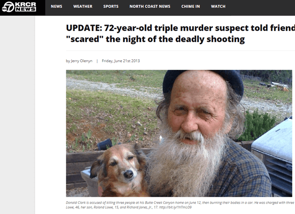
Our second story is a mystery full of twists, turns and murder that will ultimately resurrect your faith that what you think is lost, may still be found.
Frank recently wrote in saying that he listened to Genealogy Gems Podcast episode 227 and my conversation with Ran Snir, MyHeritage DNA Product Manager about their genetic genealogy tools The Theory of Family Relativity™ and AutoClusters. This got him thinking about his own test results and a frustration he has had trying to find matches and records in pursuit of this Galician roots.
Frank writes:
“Ancestry’s records are almost non-existent, except for some parish records, but this is the region from which Cuba and Argentina were populated, and the ultimate ancestry of Cubans in the US. I have done the AncestryDNA test but my matches are few and far between.
On the other hand, I have worked with a Spanish genealogist and have some records that go back to the 17th century. Is there any program like Ancestry, 23andme, or My Heritage, that can do Galician (Spanish) genealogy well.”
Regarding DNA matches and testing pools:
DNA companies test all types of people and because testers can download their results and upload them to other companies, their pools of people are becoming more similar. Generally, they don’t focus on particular groups. They just report the results based on the pool they currently have.
Regarding genealogy records:
Start with the FamilySearch Wiki page on Galicia includes links to records within each province.
Conduct a Google Search: Galician (Spanish) genealogy “Galicia”. Click here to see the Google search results.
Additional Resources:
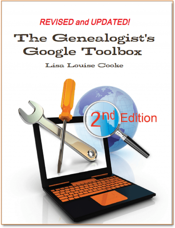
The Genealogist’s Google Toolbox Third Edition by Lisa Louise Cooke available in the Genealogy Gems Store.
Available in the Genealogy Gems Store.
Lisa’s video classes and handouts on Google search are included in Genealogy Gems Premium Membership. Learn more here.
Click to learn more about Genealogy Gems Premium Membership.
From Linda:
“I am a regular listener to your podcasts. And I am the family historian. I recently received a trove of documents from my Uncle who had been working to chart the family for 25 years. He passed away last year. His most recent quest was to find as many old family pictures as possible and I have continued to reach out to distant relatives. I enjoyed the recent podcast about the New York photographer website and hope it will help me identify people in some of these very old pictures.
(Episode 236 – Interview with David Lowe, Specialist for the Photography Collection at the New York Public Library on a free tool they provide that can help you identify your old photos. Also a discussion of how to find unindexed records at Ancestry.com.)
My question: a friend of mine has inherited all of her family’s old family pictures. The pictures are from the late 1800’s. She doesn’t know who most of the people are. She is not interested in learning and apparently there aren’t any members of the family who have taken the role of family historian. Is there anything to do with these pictures other than to dispose of them? It makes me sad to know that no one is interested. When I learned a branch of my family tree had tossed all of their old family pictures, I felt awful and it has taken me some time to accept that I might not ever find replacements for this branch.”
There are ways to make real progress identifying photos. I’m going to be covering more of this on upcoming episodes. I would start by asking your friend to write down states / counties / towns where she thinks her family lived, as well as her direct ancestors as far as she knows (even if it’s just grandparents or great grandparents.) With some basic genealogical info on the most recent members of the family and some possible locations, you could then post at least some of the photos on Deadfred.com.
This is a site where people search on families and locations and other identifying information to find unidentified photos of their family members. Many, many photos have made their way to family historians through DeadFred.
If you don’t have time to post them on DeadFred, and you do know the county where some of the photos came from, you could offer to donate them to the local genealogical society. They might be willing to take them, and their volunteers might be willing to do it.
I agree with you, it would be such a shame to toss them because you can be sure there is someone out there who would treasure them and may even hold answers.
Learn more about how to blog about your family history. It may just lead to a treasure like it did for Bill. Here is a collection of articles at Genealogy Gems on family history blogging.
Learn more about how to set up your own blog by watching the videos on how to blog at my Genealogy Gems YouTube channel.
Kathleen Ackerman graduated from Brigham Young University with a Bachelor of General Studies: Family History degree in April 2012. She now has her own research company, Finding Ties that Bind. She is also working on a Master’s Degree in Genealogy, Paleography and Heraldry from the University of Strathclyde in Scotland.
Kathleen Ackerman
Kathleen is the director for the Cave Creek Arizona Family History Center. She loves to help others as they learn about their family history. For seven years, she served as the Treasurer and British Institute Director for the International Society for British Genealogy and Family History. Besides her volunteer and school work, she spends most of her free time either working on her husband’s English and Scottish lines or playing with her granddaughter.
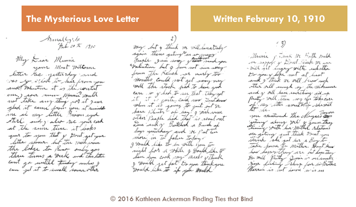
“In 2010, my mother found three pages of a letter addressed to “Mamie” among my grandparent’s things. My grandmother has passed away and my grandfather did not remember who Mamie was or why they had the letter. My mom sent me the letter in hopes that I could figure it out.”
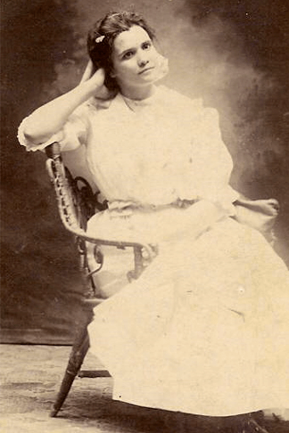
Miriam (Mamie) Smith Patelzick 1891-1911 (Photo courtesy of Kathleen Ackerman)
The last page which may have contained the writer’s signature was missing. This is where Kathleen’s search began.
The first three pages of the love letter. (Courtesy of Kathleen Ackerman)
Kathleen turned to census records from the time period, and Google Maps to verify where Medicine Lodge was in comparison to Small, Idaho, the place from which the letter was sent. No such town could be found.
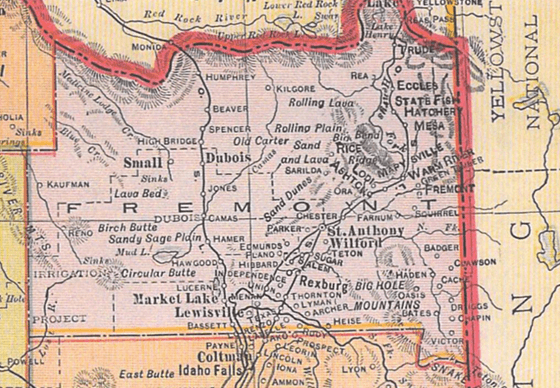
She then turned to old maps to see if the town had once existed. She used maps on the David Rumsey Historical Map Collection website. She found a map of Idaho from 1909, that showed Small, Medicine Lodge river and Reno (all mentioned in letter). They were all in Fremont County, Idaho. Her confidence that she had the right person grew.
1909 Idaho map published by Geo. F. Cram, Chicago (DavidRumsey.com)
The search moved on into vital records. A marriage certificate for Mamie and William Patelzick in Dec 1910 was located.Perhaps they had eloped?
Spoiler Alert: If you haven’t listened to the episode yet. The next image reveals the writer of the letter.
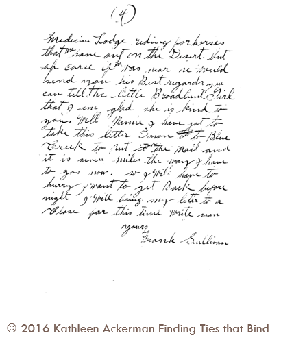
Later, Kathleen’s mother surprisingly found the final page of the letter:
Found! The last page of the love letter. (Courtesy of Kathleen Ackerman)
A surprise indeed, and a mystery solved!
Thank you to Kathleen Ackerman for sharing her story! You can visit her at her website, Finding Ties that Bind.
Announcing the Next Generation of Google for Genealogy
The Genealogist’s Google Toolbox By Lisa Louise Cooke
Discover the answers to your family history mysteries using cutting-edge Google search strategies. A comprehensive resource for all of Google’s free tools, this easy-to-follow book provides the how-to information you need in plain English. You will first gain a strong foundation in how to search quickly and effectively. Then you’ll dig deeper into solving real-life challenges that genealogists regularly face. This book will show you how to flex your new Google muscles by mining each of the free tools to deliver satisfying and enlightening results. You will develop a mastery of Google that will serve you now and for years to come.
This book features:
Step-by-step clear instructions and loads of images that help you easily follow along.
Tips for searching faster and achieving better results to solve the real challenges that genealogists face.
How to go beyond Google search by using the wide range of powerful free tools that Google offers.
Cutting-edge technology like Google Earth to tell your family’s stories in new and exciting ways!
How did World War I affect your family’s lives? Start your search with these 3 tips for finding WWI ancestors.
Our current Genealogy Gems Book Club title takes place at the outset of WWI.The Summer Before the War: A Novel by Helen Simonson has endearing characters who experience fairly light-hearted dramas–and then they are plunged into war.
Through their eyes, readers begin to understand that those who lived through ‘the Great War’ experienced something totally unprecedented. There had never been such a massive loss of life and devastation.
1. Ask family what they know. Ask all living relatives what they know about ancestors’ involvement in World War I. Listen for stories about anyone who may have served in the military, dodged military service, took care of things on the homefront, lost their own lives or loved ones or lived in an area affected by the war. Ask about any old documents, photos or letters that may survive.
There are lots of ways to ask your relatives these questions. Poll everyone at your next family gathering or reunion. Use Facebook (click here for some great tips) or other social media. Connect with other tree owners who have documented ancestors of WWI interest (see step 2, below) through communication tools provided at sites such as Ancestry.com, MyHeritage.com and FamilySearch.org.
2. Identify ancestors affected by WWI. Look for families and individuals who were alive between 1914 and 1918. Where did they live? Was it an active war zone? Research local histories and maps to determine how their city–or even neighborhood or property–was affected. Scan death dates on your family tree–did anyone living in a war zone die during that time period?
Were they in a country that sent troops to war? If so, look for soldiers on your tree. The age of those who served in World War I varied. In general, look for men born between 1880 and 1900 who were alive in 1914. Again, look for death dates during the war.
3. Search military records on genealogy websites.Fold3.com’s WWI landing page is the place to start for WWI ancestors in the U.S., since it specializes in military records (you may be able to access it from your home library). Ancestry.com users can go to this landing page to search all WWI records from the U.S. and here to search U.K. records. Findmypast.com users can search WWI records here, including an extensive collection of British military records but also others from around the world. If you’re searching U.S. records, remember that draft registrations are not records of military service.
If you’re looking for a country or region not represented in these online collections, start Googling! Google search phrases such as “Germany WWI genealogy” will bring up results like these. (Click here to watch free video tutorials about Google searching for genealogy records.) You may discover new databases online or records collections you could access through archives or libraries.
Available at http://genealogygems.com
These tips are just to get you started. As you discover records, you’ll have a better sense for the stories of your WWI ancestors. Then you can start chasing those stories in newspapers, local histories and other sources. Turn to a book like Lisa Louise Cooke’s How to Find Your Family History in Newspapers to learn
British volunteers for “Kitchener’s Army” waiting for their pay in the churchyard of St. Martin-in-the-Fields, Trafalgar Square, London. August 1914. Wikimedia Commons Image
sleuthing skills you’ll need for searching out your WWI family stories in the news.
Ever thought of visiting your childhood home? Here’s a story about people who are actually buying theirs back. For the rest of us, here’s how to use Google and Google Earth to revisit your childhood home and relive some memories–without spending a dime.
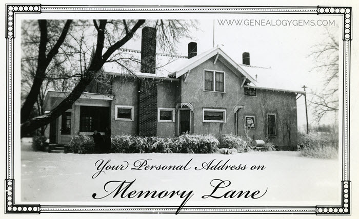
Your childhood home–or perhaps another beloved family home–is your own personal address on Memory Lane. Who wouldn’t love to stroll up to its doors and recapture some memories?
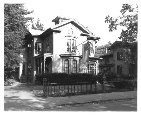
The image above is of my husband’s great grandfather’s home in Winthrop, Minnesota. It’s a home that I have many photos of, have researched, and have come to feel personally connected to although I’ve never seen it in person. It’s one of many ancestral homes that I yearn to visit one day. So as you can imagine, I really enjoyed this report from The Wall Street Journal about a few lucky folks who are living the dream of not only visiting, but owning and restoring, their childhood home.
Even if you’re not interested in buying back an old family home, many of us are curious about the houses we used to love. Are those houses still there? What do they look like now? What else can we learn about them?
Let’s explore three ideas to help you stroll down memory lane. Then, I’ll share a discovery from a Genealogy Gems Premium podcast listener who recently dropped me a line.
1. Find the address for your childhood home
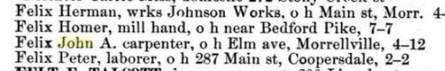
If you don’t recall the street address of your favorite family home, ask a relative or look it up. For U.S. addresses since 1940, you might start with the U.S. Public Records Index, searchable in part or full at Ancestry.com (volumes 1 and 2 for 1950-1993), FamilySearch.org or MyHeritage.com (click here to learn more about that database). Look also in records such as:
Johnstown, PA city directory listing, 1889, digitized on Ancestry.com.
draft registrations and other military paperwork
Social Security application forms, known as SS-5 forms (click here to learn more about them)
deeds
old family letters
newspaper articles (click here for tips on searching digitized newspaper content by address)
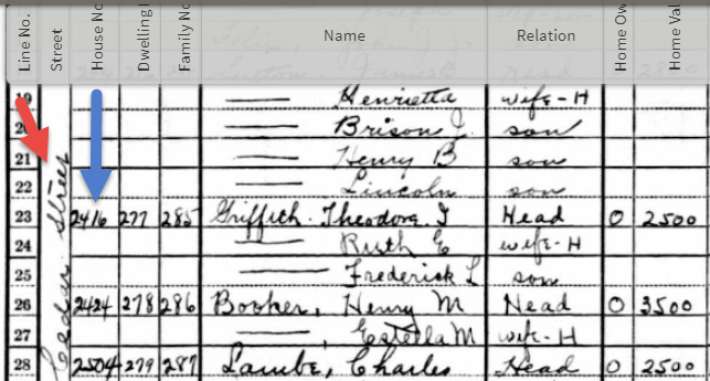
For U.S. addresses from 1880-1940, look to U.S. census records, which include street names and house numbers. In the example below from the 1930 census, you can see “Cedar Street” written vertically by the red arrow, and the house number written for each household entry, as shown in blue.
From the 1930 US census, Ancestry.com.
If you can’t find an address on an old record, but you think you could navigate yourself there on a map, it’s time to go to Google Earth and fly yourself there!
2. Use Google Earth to view your childhood home now
Google Earth is your on-ramp to your own personal Memory Lane. Go to the site, enter an address, and watch yourself “fly” to that address. If you don’t know an exact address but you know where to look, enter a street name or even a city. Then zoom in to the neighborhood and street section of interest. Activate Street View, if it’s available. Not sure how to do that? Watch my free Google Earth for Genealogy Video Class to get started.
Once you’ve found the location, take a close look. Is the house still there? What does it look like now? How has the landscape changed? The neighborhood?
You can use Google Earth to revisit your own childhood home or another family landmark, such as an ancestor’s homestead or burial place. (Click here to read about one genealogist’s virtual trip to an ancestor’s business using Google Earth’s Street View, and click here to see how another genealogist used historical map overlays in Google Earth to identify an old home’s location.)
3. Google the address of your childhood home
Googling the address of your family home may produce unexpected and interesting results like these:
a) Sale listings. If your house has been on the market in recent years, you may be able to find a listing with great details, and even pictures of the inside today. Top Google search results from specific addresses often bring up real estate websites with varying degrees of information, such as square footage, current estimated value, year built, most recent sale date and price, and more. Weed through these entries to see whether Zillow or another similar site shows a current or past listing for sale or rent. These may contain more details and may even have interior and exterior pictures of the house as it is now.
Watch closely—Google may bring up houses nearby, not the one you’re looking for. But even a neighborhood listing for a house built on a similar floor plan may jog your memories of the home and may give you a sense of what the area is like now.
b) Historical information. A Google search result may bring up historical news coverage or obituaries from digitized newspaper websites like Newspapers.com (a subscription may be required to view these in full). Or you may find something really fascinating, like a discovery made by Genealogy Gems Premium member Heather. After listening to me talk about this subject in Premium Podcast episode 141 (click here to subscribe), Heather wrote me this email:
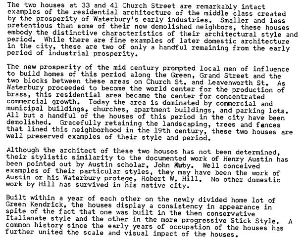
“I love listening to the podcasts while driving to and from work, often sharing my own thoughts with you. This happened yesterday while listening to the latest Premium Podcast episode on family homes. I decided that I had to write and share what I managed to find! Since I have deep family roots in Connecticut back to 1650s, I managed to find a few family homes, but I started searching with the more recent generations and addresses that I knew. The two homes where my great-grandparents (Inez Hart and John Milton Burrall) and my great-grand aunts (Mary and Lucy Burrall) lived were written up in an application for the National Register of Historic Places!
The National Park Service is working on digitizing these applications. I found the application with a narrative description of the home and pictures of the interior and exterior. I have found other applications that have also included some genealogy of the family who lived in the home. Here is the website for the National Park Service and the database search page.”
Thanks for sending these in, Heather! And for sending along copies of the applications she found. The multi-page applications (more than 10 pages each!) include historical background on the buildings and former owners, as well as photos and site maps. Above is a photo–and below is an excerpt–from these applications.
Disclosure: This post contains affiliate links and Genealogy Gems will be compensated if you make a purchase (at no additional cost to you) after clicking on these links. Thank you for supporting Genealogy Gems!


 “I love listening to the podcasts while driving to and from work, often sharing my own thoughts with you. This happened yesterday while listening to the latest Premium Podcast episode on family homes. I decided that I had to write and share what I managed to find! Since I have deep family roots in Connecticut back to 1650s, I managed to find a few family homes, but I started searching with the more recent generations and addresses that I knew. The two homes where my great-grandparents (Inez Hart and John Milton Burrall) and my great-grand aunts (Mary and Lucy Burrall) lived were written up in an application for the National Register of Historic Places!