Ebola Patients Would Likely Have Been Sent Here 130 Years Ago
When Liberian national Thomas Eric Duncan was diagnosed with Ebola it was unnerving for everyone here in the U.S. As a new Dallas area resident, and someone who was hopping from plane to plane for a Fall series of speaking engagements, it definitely gave me pause.
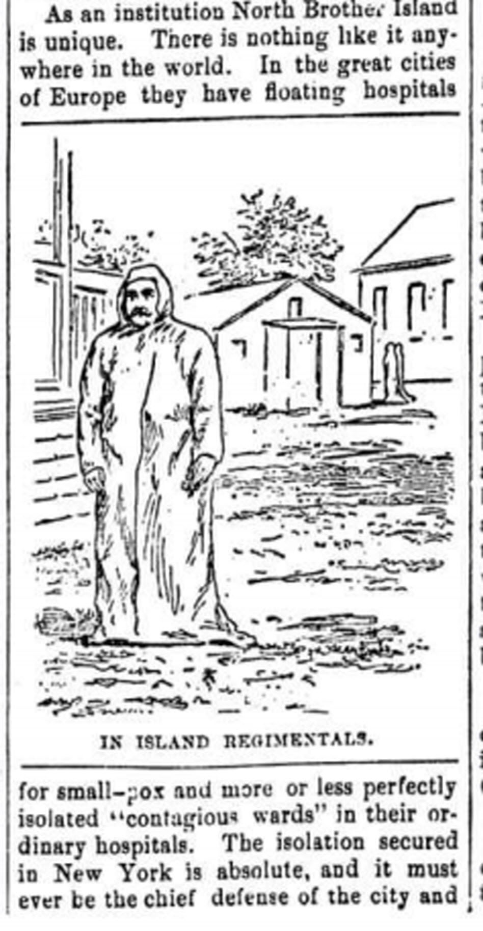
The Abbeville press and banner., October 12, 1892, Image 6/ www.chroniclingamerica.com
Epidemics, quarantines, and communities trying to protect citizens have been age old dilemmas, so it makes sense to look back through history at the strategies employed. There is much to be learned.
If we ask the question “what would have happened if Ebola had struck the U.S. 130 years ago?” we don’t have to look much farther than the location of one of the most recent Ebola patient: New York.
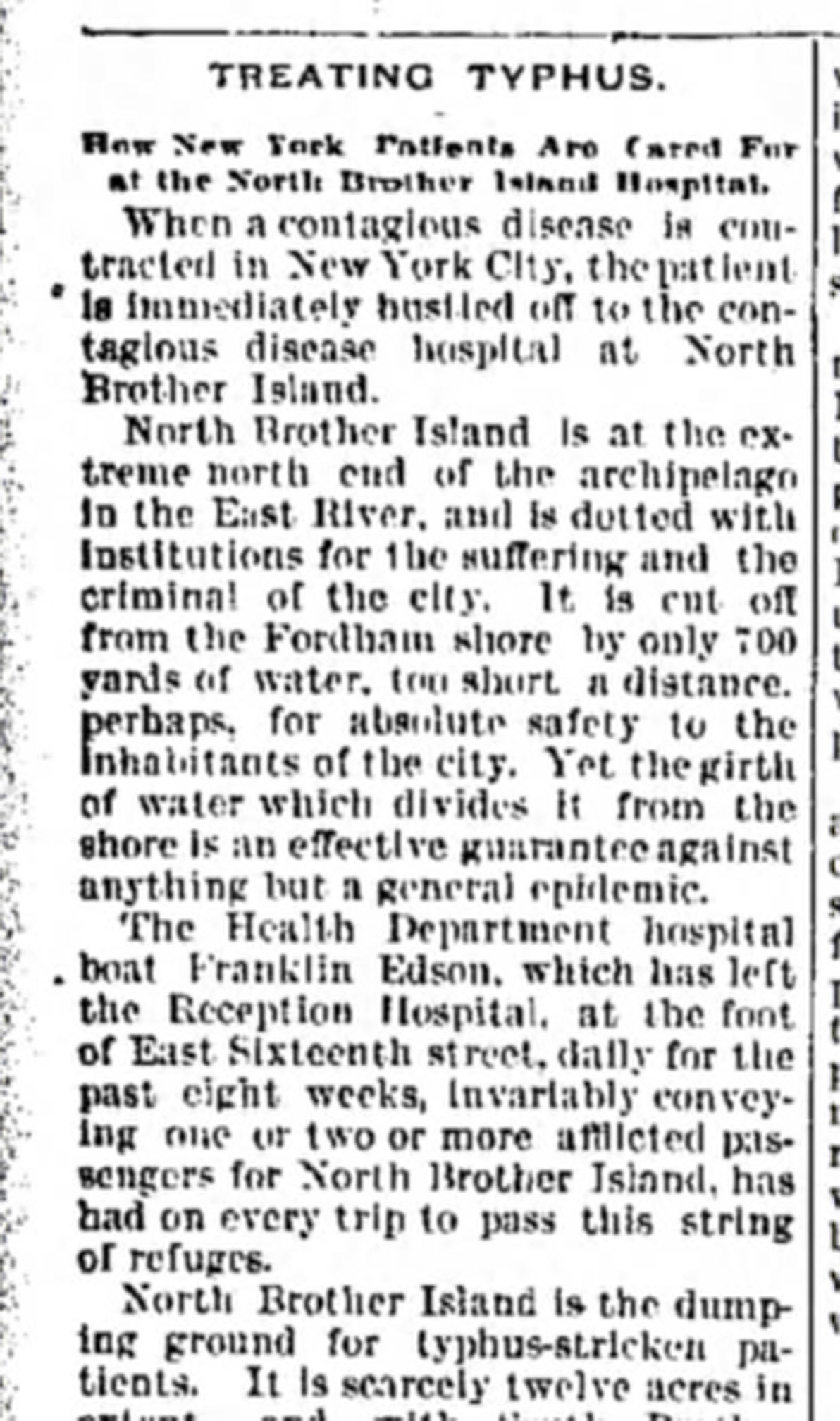
from the Humboldt Republican (Humboldt, Iowa) March 31, 1892
Courtesy www.Newspapers.com
In New York’s East River, tucked between the Bronx and Rikers Island lies North Brother Island, where in 1885 Riverside Hospital was relocated from Blackwell’s Island to isolate and treat small pox patients. From there it expanded to include the quarantine of other diseases.
North Brother Island stands idle today, closed to the public. However from 1907-1910 and 1915-1938 it housed the notorious Typhoid Mary, closing shortly after her death.
Although today the island is closed to the public, anyone can visit virtually with the aid of Google Earth. Join me on a 5+ minute tour of North Brother Island featuring the magazine and newspaper articles of the day, and written, audio and video tours of how it stands today a shell of what it once was. Click here to download and play my Google Earth Historic Tour KMZ file on your computer. It will be added to your “Places” panel in Google Earth under “Temporary Places.” Open the folder and click the “click to play the tour” icon. Be sure your speakers are on! And take time to click to watch the video and view the articles in the placemarks.
Don’t have Google Earth loaded yet? Download it free here.
If you would like to learn to create your own Google Earth family history tours watch this free video and then pick up your copies of Google Earth of Genealogy Volume I and Volume II.
Learn about Homestead Land Records with Lisa Louise Cooke
Homestead land records tell us more about our forebears who settled the western U.S. Learn more with Lisa Louise Cooke at the Land Records and Genealogy Symposium July 14-15, 2017 in Beatrice, Nebraska.

Lisa Louise Cooke will be a featured speaker at the Land Records and Genealogy Symposium in Beatrice, Nebraska on July 14-15, 2017. The 2-day event is co-sponsored by the Homestead National Monument of America, a unit of the National Park Service, and the Beatrice Campus of Southeast Community College.
Homestead land records and our ancestors

Omer Madison Kem, (later, Representative to the United States Congress) in front of his sod house in Nebraska (1886). Click image to view at American Memory (Library of Congress digital archive).
“The Homestead Act of 1862 had a profound affect on the United States and throughout the world,” states the symposium webpage. “Under the provisions of this law, the U.S. government gave away 270 million acres of land to 1.6 million individuals and families for the purposes of settlement and cultivation. Today there may be as many as 93 million descendants of homesteaders.”
Our homesteading ancestors may show up in land patent records and related paperwork. Over five million documents are searchable by name and location at the Bureau of Land Management’s General Land Office Records website. These databases found at major genealogy websites may also be helpful for finding homestead land records and related paperwork:
- Free at FamilySearch.org: United States, Cancelled, Relinquished, or Rejected Land Entry Case Files, 1861-1932;
- By subscription at Ancestry.com: U.S., Homestead Records, 1861-1908;
- By subscription at Fold3.com: Homestead Records NE
Out ancestors’ homestead land records may reveal when they purchased and/or applied for land and where they were living at the time. In many instances, immigrants had to be citizens to purchase land, so you may find information about their naturalization. You’ll often find land records in the same area purchased by relatives, which can help you reconstruct family groups and more confidently identify your family.
Participants in the Land Records and Genealogy Symposium will learn to use records of different kinds–and strategies for researching them–in their genealogical and historical research. Lisa Louise Cooke’s lectures will focus on using powerful online tools to map out your family history and find mention of ancestors that may be buried deep in online resources. Other lectures will also help you chart the stories of your frontier ancestors, many of them immigrants, who purchased land from the government in the Midwest and Western United States.
What: Land Records and Genealogy Symposium, co-sponsored by the Homestead National Monument of America (National Park Service) and the Beatrice Campus of Southeast Community College
When: July 14-15, 2017 (8 am – 4 pm on Friday, with optional dinner presentation; 8:30 am – 3 pm on Saturday)
Where: Southeast Community College, Beatrice, Nebraska
Can’t make it to Nebraska?
 Learn to plot your ancestors’ homestead records in Google Earth in Lisa Louise Cooke’s Google Earth for Genealogy video series.
Genealogy Gems Premium website members can learn more about homestead land records in Genealogy Gems Premium Podcast episode 33, in an interview with expert Billie Edgington. (Click here to learn more about all the benefits of Premium membership, including access to the full Premium Podcast archive of nearly 150 episodes!)
Click here to see all of Lisa’s upcoming presentations: is there one near you?