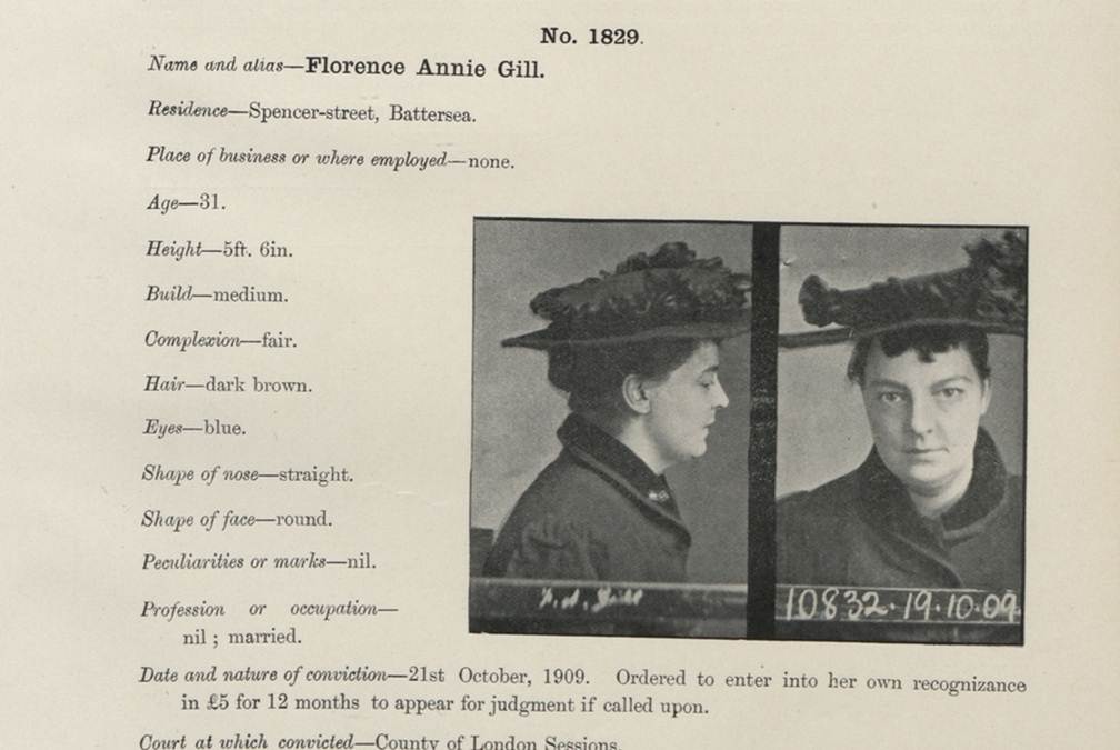
If you have British roots, you’ll want to check out the new collection available on Findmypast.com: a half million criminal records dating from 1770-1934!
This sounds like a pretty gripping collection, whether you’ve got British roots or not. It contains records like mug shots, court documents, appeals letters and registers from prison ships (which were used when mainland prisons were crowded). According to Findmypast.com, the records “provide a wide variety of color, detail and fascinating social history, chronicling the fate of criminals ranging from fraudsters, counterfeiters, thieves and murderers and their victims.” The 500,000 records you can search now are only a fifth of the full collection of 2.5 million that will be online soon.
The company calls this the largest collection of historical criminal records from England and Wales to be published online and is done in association with the National Archives (UK). Findmypast.com members can click here to access the criminal collection directly (make sure the box for “Institutes and Organizations” is checked).
Here’s a little more background on connections between British convicts and the U.S. and Australia….
During colonial times, Britain often punished criminals by forcing them to emigrate. The most famous destination was Australia: the first British settlement on that continent in 1787 was actually a penal colony. Australia celebrates that fact about its heritage today: learn more about the “First Fleet’s” arrival here.
Up to about 50,000 British convicts were also forced to emigrate to the American colonies during the 1700s. These included prisoners of war from Ireland and Scotland. Read more about this in Bound for America: The Transportation of British Convicts to the Colonies, 1718-1775 (Clarendon Paperbacks) by A. Roger Ekirch. Findmypast.com isn’t able to tell us yet how many records in the criminal collection relate to forced emigrations, but anyone with roots in the U.K. should check out this collection for sure.
Ancestry.com has acquired FindAGrave.com, home of 106 million grave records. At this free “virtual cemetery,” users can create memorials for deceased individuals. Anyone may contribute photos, leave “virtual flowers” and submit data to these memorials. Genealogists use Find a Grave to locate gravemarkers, find hints about relatives’ lives and even connect with others who share an interest in their buy trichomoniasis medication relatives.
Find A Grave’s FAQ page about the Ancestry acquisition addresses what’s on everyone’s mind: how will things change for Find A Grave users and content? Owner Jim Tipton says things will pretty much stay the same: free, protected, and accessible. Read the details on Find A Grave.
Every where we go, we are snapping pictures. Whether you are interested in capturing your current family history or want to preserve the past through pictures, photo editing apps and software are a must! Read more to learn what software and apps are out there for the active genealogist who loves to take pictures.
A Gems reader recently asked if we have any suggestions on photo editing software and apps for family history. Our Genealogy Gems team members are each active in their personal family history and are quite savvy when it comes to some of the best photo editing apps and software out there.
Lisa Louise Cooke’s Favorite Photo Editing Software and Apps
Lisa shares:
I think one of the best photo editing software programs out there is Adobe Photoshop Elements, the consumer version of the high-powered Photoshop CS/CC software. On my mobile device, Photoshop Express is my go-to photo editing app which I discuss in Chapter 8 of my book Mobile Genealogy. In fact, I use the app far more for the photos I’m actively taking with my iPhone 6 Plus than the software on my computer.
Adobe Photoshop Elements is an ideal editor for entry-level photographers, image editors and hobbyists. You’ll find most of the features of the more expensive professional version, but with fewer and simpler options. It allows you to create, edit, organize, and share your images to social media sites. Use the built-in Guides to quickly accomplish your goals.
Adobe’s Photoshop Express app can be downloaded to your mobile device for free from Google Play (for Android) or the Apple Store (for iPhones.)
Using the Photo Express Photo Editing App for Photo Restoration
If you want to restore old family photos, this app is now also capable of doing a lovely job with the new Blemish Removal tool. The app allows you to access your photos straight from Dropbox, as well as Adobe Creative Cloud, and Facebook. You can copy the old photos you want to edit to a dedicated folder in Dropbox. Remember, always leave your master digital photos where they are on your computer, and make sure your computer is backed up. (The Genealogy Gems Podcast uses and recommends Backblaze.)
How to add photos to Adobe Photoshop Express:
On the computer where your photos are stored, go into Dropbox (either your Dropbox desktop application, or sign in to your account at www.dropbox.com)
Create a folder called “Photos for Editing”
Save copies of the photos you want to edit into the folder you created, leaving the originals where they are on your hard drive
On your tablet, tap the Adobe Photoshop Express app
Tap Dropbox. (See the chapter on File Sharing and Storage for more information on Dropbox)
Tap the “Photos for Editing” folder
Tap the photo you want to edit
The photo is now on your screen and ready to edit and embellish
When editing is complete, tap Close, then Save
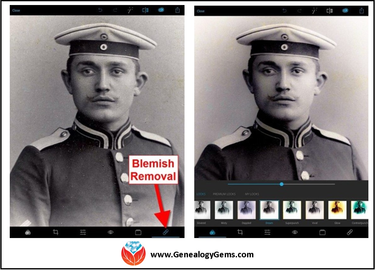
Above is a photo of Lisa’s great-grandfather. On the left is the original scan, and on the right is restoration with the Blemish Removal tool (the icon looks like a band-aid.) After the touch up, Lisa applied the Dream filter which provided a bit more clarity and softened the rough spots in the background. Dream is one of the many free “Looks” available in the app, in addition to “Premium Looks” filters that you can purchase. She loves the fact that if she finds a certain combination of filters is working well, she can save it under “My Looks.” This saves time in the future because with one tap, you can apply your own special mix.
Amie’s Favorite Photo Editing Software and Apps
Amie says:
“One of my favorite photo editing tools is Pixlr Express. It is easy to use without having to read through the ‘instructions.’ It is a web-based tool or a mobile app. It makes correcting and enhancing my old photos a breeze.”
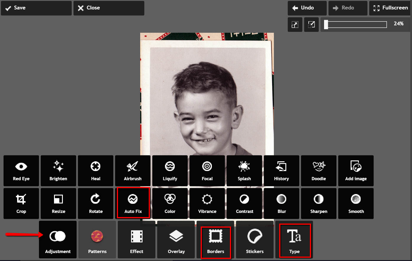
Using Pixlr Express
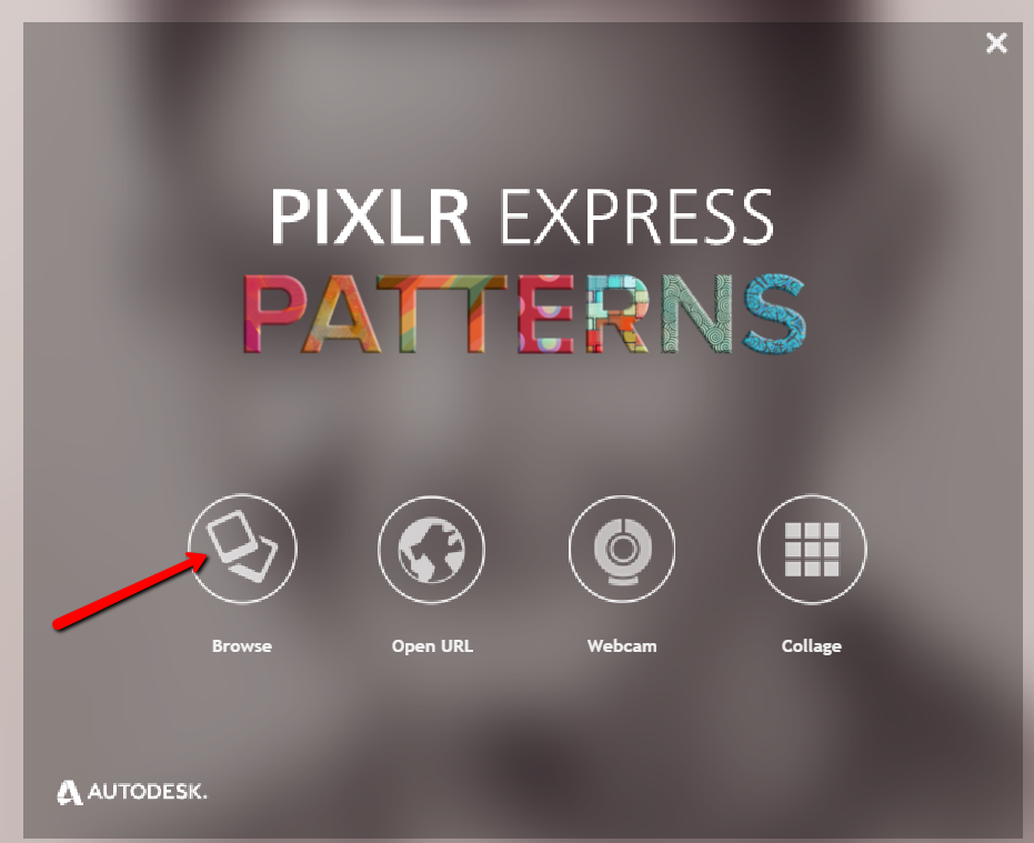
Pixlr Express is a web-based tool and a mobile app. Resize, rotate, filter, correct, and even add borders and text. Pixlr Express is free to use, which is always a plus. On your laptop, simply go to www.pixlr.com/express. Click on Browse.
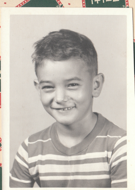
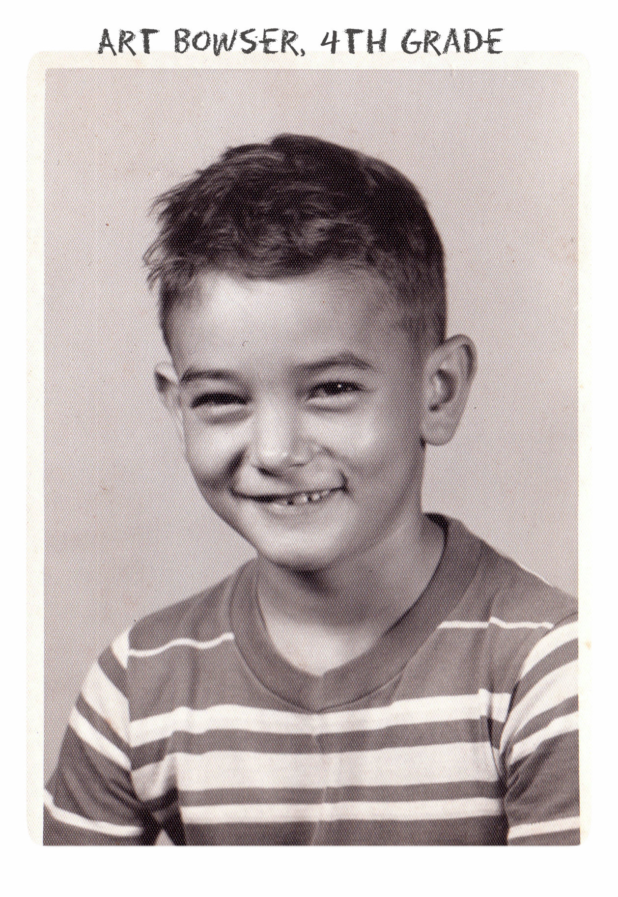
Choose the photo you wish to edit. The example below is a cute little picture of Amie’s dad in the fourth grade.
It could use some more color definition, maybe a new border to clean up the edges, and a caption on the front so that when shared, others will know who it is. To begin doing these edits, first click Adjustment.
From the icons that pop-up, choose Auto Fix. It really looks great with just the click of one button! Add a fun border if you wish and click Type to add the text you want. Here’s the finished product in less than 3 minutes:
Don’t you just love it!
Enlisting the Help of Others
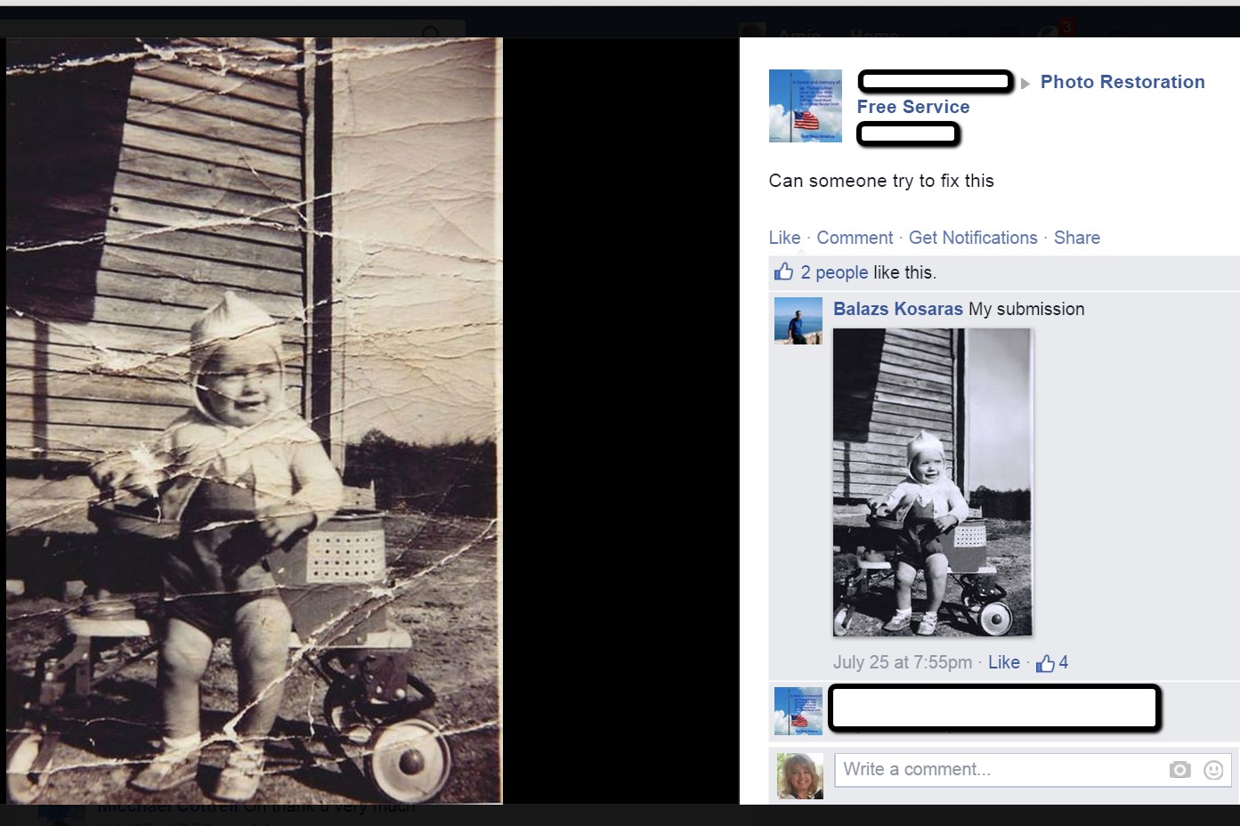
In some cases, our old photos are in seriously bad shape. We could pay to have a professional doctor it up, but I enlist the help of others at one of my favorite Facebook groups. Photo Restoration Free Service group on Facebook is dedicated to fixing images for free. Many of the people offering their talents are truly amazing. One man in particular caught my attention and gave me permission to use a before and after shot of his work. Thank you to Balazs and others who gave their permission for the before and after screenshot you see here.
What are your favorite photo editing apps? Do you use a different app for your mobile device? We’d love to hear from you and what you are doing to make the most of your treasured family photos. Please leave a comment in the comment section below.
Sunny’s Tips for Restoration of Digital Documents
It’s not only the pictures of ancestors we sometimes need to restore, but it can also be those hard-to-read images of documents. When dealing with this problem, Sunny says:
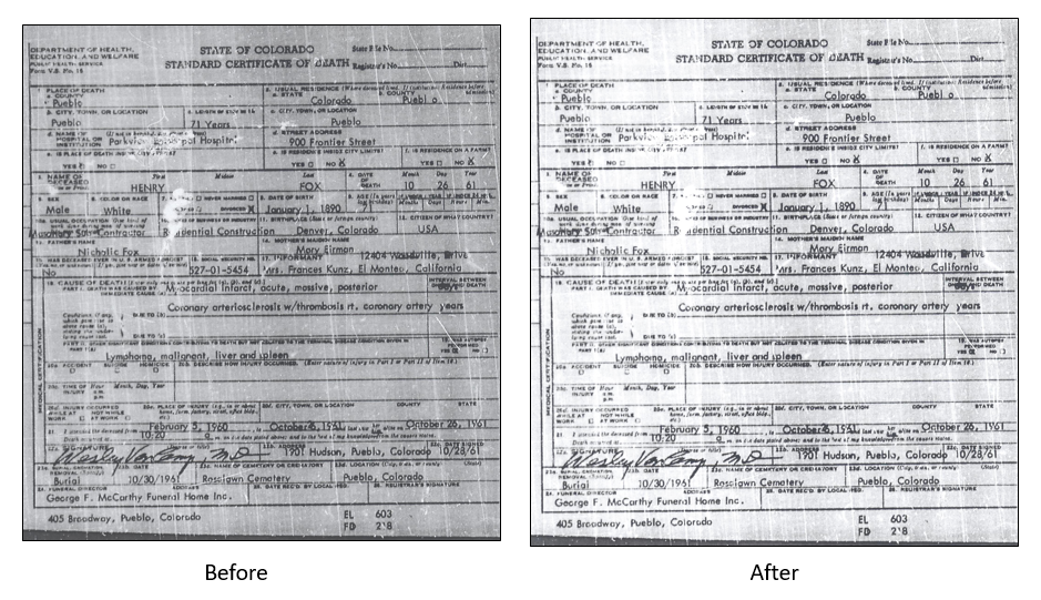
“I do most editing on my laptop. This is where the nearest free software is and the default photo editor for Microsoft 2010. Most of the time, I just want to tweak the lighting: brighten up a scanned image or heighten the contrast in the image. To do this quickly, I open the image, then click Edit Pictures > Brightness and Contrast. In the Before/After images shown here, I just adjusted the midtones (+22) to make the gray areas lighter, then upped the contrast (+43).”
With so many photo editing apps available, it is hard to know what is going to work best for your needs. We hope that our experiences might help you to decide! We would love to see some of your before and after photos of a remarkable restoration. Will you share with us on our Facebook page? We’d love to hear from you!
VIDEO & SHOW NOTES: Video #4 of our 25 Websites for Genealogy Playlist. In this video, my guest presenter Gena Philibert-Ortega covers digital collection websites that are must-haves for family history research. You’ll find plenty of genealogy gems waiting for free at websites #18 through 22.
Websites 18 through 22 of our 25 Websites for Genealogy
Some of these websites will be new to you, and others are going to be very familiar to you. In talking about the familiar websites, I want to get you thinking about them differently, explain a little bit more about what you can do at these websites, and how to get the most out of them.
In this series of 25 Websites for Genealogy, we’re going to be looking at websites in different categories. Our third category is Digital Collection websites (#18 through 22).
At the DPLA you can search for public domain research materials that will benefit your genealogy research. It offers a searchable access to millions of items including photographs, manuscripts, books, sounds, moving images, and more from libraries, archives, and museums around the United States.
According to Lisa Louise Cooke, Google Books is the tool you should use every day for genealogy. It puts 25 million digitized and searchable free books at your fingertips.
Learn much more about how to get the most out of Google Books with these videos by Lisa Louise Cooke:
If you’re looking for new information about your family history, an important website to add to your research list is the Internet Archive. It’s a free website that attempts to archive the web, and that includes a vast array of genealogy materials!
Founded in 2008, the non-profit HathiTrust provides access to 18+ million digitized items in the HathiTrust Digital Library. Reading access varies depending on the item and whether you belong to a participating organization, but it’s definitely worth a look.
New North American genealogy records online this week! Featured are U.S. military, passenger and yearbook records (including WWII film footage); regional collections for New England and Great Lakes; Congressional statutes; and over 63 million Mexican genealogy records...
 deceased individuals. Anyone may contribute photos, leave “virtual flowers” and submit data to these memorials. Genealogists use Find a Grave to locate gravemarkers, find hints about relatives’ lives and even connect with others who share an interest in their
 Don’t you just love it!