U.S. land entry case files are now free to browse at FamilySearch. We give you a link to a free index to those–and MORE new and updated records for Argentina, Australia, England, France, Germany, Ireland, the Netherlands, New Zealand, Scotland, and other U.S. collections (Crimean War photos, Illinois birth certificates, and more).
Featured: U.S. Land Entry Case Files
Over a quarter million record images have been added to the free FamilySearch database of United States, Cancelled, Relinquished, or Rejected Land Entry Case Files, 1861-1932. This collection gives researchers access to browsable images of case files for those who unsuccessfully applied for homesteads (such as the one shown above; click the image to see its citation), mining claims, and land pre-emptions. Even better–the National Archives website hosts a name index to speed along your search of the browsable records at FamilySearch!
According to a National Archives description of the original collection, “A file may contain the original entry application, correspondence between the officials of the Lincoln Land Office and the GLO in Washington, D.C., receipts for fees paid, public notices, affidavits and witness statements, proof of military service, the entryman’s naturalization records, and documents concerning the cancellation or relinquishment of the entry.”
This collection of Land Entry Case Files includes Kansas land offices at Dodge City and Topeka and Nebraska land offices at Alliance, Broken Bow, Lincoln, North Platte, O’Neill, and Valentine. More records will be forthcoming.
The British Newspaper Archive recently announced it now has a title online for every county in England. (Click here to learn more.) They’ve also updated several London titles and added two new ones, among them the North London News and West London Observer.
Findmypast.com has recently added more than 4.5 million records that can help those searching for ancestors in Wiltshire, in southwest England:
Also new on the site is a collection called Baden-Württemberg, Germany, Family Tables, 1550-1985. A tip from the collection description: “Use the browse fields to sort through the images by City or District and Description of records.”
Ireland—Newspapers
Nearly a million new articles have been added to Findmypast’s enormous collection of digitized Irish newspapers. This unique collection now hosts more than 35 million articles.
Newspapers.com has added Louisville, Kentucky’s Courier-Journal to its collections of digitized newspapers. Basic subscribers have access to just shy of 100 years’ worth of issues (1830-1922) and Publisher Extra subscribers also may access more recent years (1923-2016).
A new online database of The Michigan Daily brings more than 23,000 issues digitally searchable. This is the student newspaper of the University of Michigan. The newspaper archive spans 125 years: 1890-2014. Click here to search it for free.
Google your way to MORE genealogy records like these
Wish you could find similar records for another time or place? Use Google search strategies to target the record types, places and even a specific range of years. You can even search for digitized photographs on Google! Click here to read more about Googling old records online.
Disclosure: This article contains affiliate links and Genealogy Gems will be compensated if you make a purchase after clicking on these links (at no additional cost to you). Thank you for supporting Genealogy Gems!
It’s a common Pennsylvania genealogy brick wall: “My ancestors are from PA—but I don’t know where!” Pennsylvania expert Jim Beidler has strategies that may help narrow down the needle-in-a-haystack problem of identifying your ancestor’s home county. Here, we also add...
Great comments from you: An inspiring Google Books success story, how one listener gets her shy husband talking about his life story, and a listener’s own version of the poem, “Where I’m From”
The Archive Lady talks to us about historical scrapbooks at archives that may be packed with genealogy gems for us
Pat’s tip: When someone is shy about sharing life stories, interview them informally while traveling. Pat uses her iPad to transcribe his responses, then polishes it up when she gets home and transfers it to her own computer. “Eventually we will have enough to write the story of his life, with lots of pictures. And it’s completely painless.”
MAILBOX: GOOGLE BOOKS SUCCESS STORY FROM KIM
Click here for another inspiring genealogy discovery using Google Books?with how-to tips and a free video preview of Lisa Louise Cooke’s Premium video tutorial, “Google Books: The Tool You Need Every Day”
MAILBOX: “WHERE I’M FROM” POEM SUBMISSION
Genealogy Gems Podcast Episode 185: Learn more about the “Where I’m From” poetry project and hear a conversation with the original author, Kentucky poet laureate George Ella Lyon.
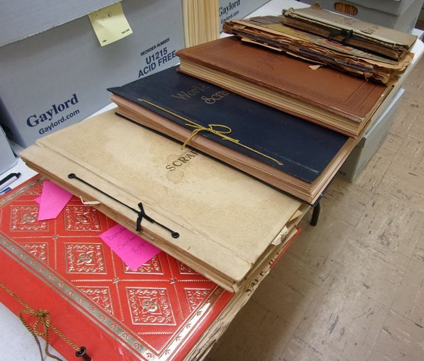
THE ARCHIVE LADY: HISTORICAL SCRAPBOOKS
Scrapbooks are one of my favorite record sources to do genealogy research in and to also process in the archives. There are all kinds of scrapbooks; each and every one is unique and one-of-a-kind. They were put together with love and the hope that what was saved and pasted onto those pages will be remembered.
The origins of scrapbooking is said to go back to the 15th century in England and it is still a hobby enjoyed by many today. Most archives, libraries, historical and genealogical societies have scrapbooks in their collections. They will most likely be found in the Manuscript Collection as part of a specifically named collection.
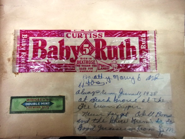
Scrapbooks contain all kinds of wonderful genealogical records, photographs and ephemera. There is even a scrapbook in the Houston County, Tennessee Archives that has candy bar wrappers pasted in it. This particular scrapbook is one of my absolute favorites. It was compiled and owned by Evelyn Ellis and dates to the 1930’s and 1940’s.
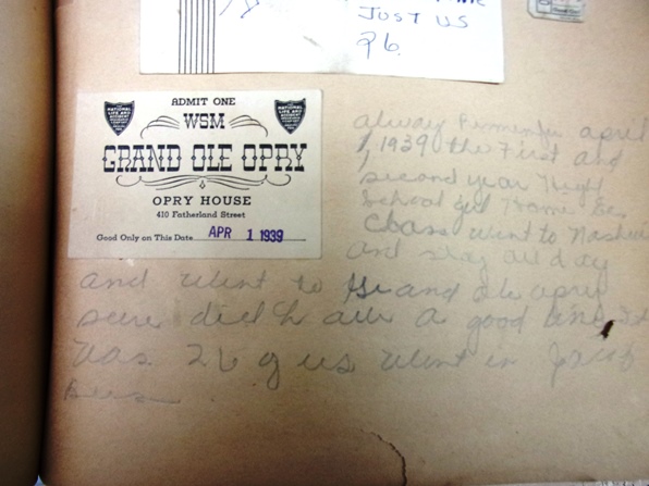
Among the normal newspaper clippings and event programs are interesting pieces such as a Baby Ruth candy bar wrapper with a handwritten note by Evelyn that reads “Always remember June 11, 1938 at Beach Grove at the Ice Cream Supper.” There is also an original ticket pasted into the scrapbook from the Grand Ole Opry in Nashville, Tennessee where Evelyn Ellis visited and recorded her comments on April 1, 1939.
There are scrapbooks for just about any subject. Aside from personal scrapbooks, you can find war scrapbooks, obituary clipping scrapbooks and scrapbooks that collected and recorded local or national events. The obituaries found in scrapbooks could be a real find because sometimes they are the only pieces of the newspaper that survive and can be a treasure trove for any genealogist. Many scrapbooks contain one-of-a-kind documents, photographs and ephemera.
To find scrapbooks in an archive, ask the archivist if they have any scrapbooks in their records collections. Many times scrapbooks are housed with a particular manuscript collection and will be listed in the finding aid. Some archives have a collection of just scrapbooks that have been donated to them and can be easily accessed. Most scrapbooks will not be on research shelves and will be stored in back rooms at the archives and will have to be requested. You should also check the archives online catalog for any listings of scrapbooks before you jump in the car and drive to the archives.
I encourage all genealogists to check with the archive in the area where your ancestors were from and see if they have any scrapbooks in their archived records collections. Scrapbooks are like time capsules: you don’t know what will be found in them until you open them up.
Start creating fabulous, irresistible videos about your family history with Animoto.com. You don’t need special video-editing skills: just drag and drop your photos and videos, pick a layout and music, add a little text and voila! You’ve got an awesome video! Try this out for yourself at Animoto.
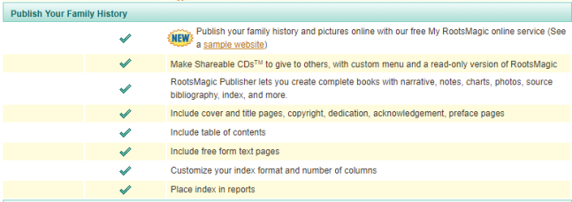
RootsMagic family history software has publishing tools (for print and online publishing):
Visit www.RootsMagic.com
Lisa Louise Cooke uses and recommends RootsMagic family history software. From within RootsMagic, you can search historical records on FamilySearch.org, Findmypast.com and MyHeritage.com. RootsMagic is now fully integrated with Ancestry.com: you can sync your RootsMagic trees with your Ancestry.com trees and search records on the site.
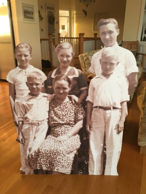
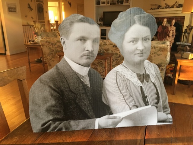
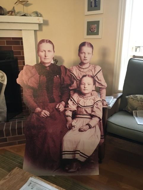
A BRILLIANT WAY TO “MEET” YOUR ANCESTOR
Your DNA Guide Diahan Southard shared this story from Christine:
“Friday night I brought out large cut out of my Grandmother, Christine Doering, sitting in an easy chair so it looks like she is talking with you, and I played a recording done in 1970’s of her talking and giggling about coming to America in 1896 at the age of 9. For some they had never heard her voice before.”
Lisa Louise Cooke, Host and Producer
Sunny Morton, Editor
Diahan Southard, Your DNA Guide, Content Contributor
Vienna Thomas, Associate Producer
Hannah Fullerton, Production Assistant
Lacey Cooke, Service Manager
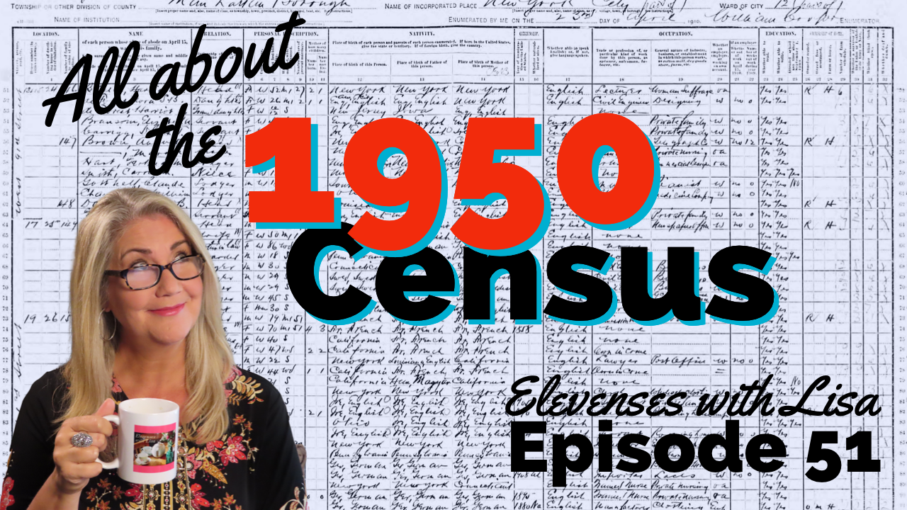
In Elevenses with Lisa episode 79 Lisa Louise Cooke explains:
How to find 1950 US Census Enumeration District (ED) Maps
The purpose behind them and how to interpret the maps
Ways to use the maps for your genealogy
This is a follow up to episode 51 on The 1950 Census for Genealogy. In that episode I discussed the importance of finding your ancestors’ enumeration district numbers in order to be able to find them when the digitized images are released (before the index is available.) In this episode I will walk you through how to locate the enumeration district (ED) number and then find the actual 1950 US Census ED map. We’ll wrap things up with a quick update on the release of the 1950 US Federal Census.
Episode 79 Show Notes
(Get your ad-free Show Notes Cheat Sheet at the bottom of this page in the Resources section.)
As I mentioned in Elevenses with Lisa episode 51 The 1950 Census for Genealogy, prior to 1880, U.S. Marshalls were the enumerators for the federal decennial census. Starting with the 1880 census enumerators were hired and they were each assigned an enumeration district, also known as an ED. These districts had to be mapped out so that the enumerators knew the area they were responsible for counting. Therefore, maps are drawn in anticipation of each census being taken, including the 1950 census.
Learn more by watching episode 51 on the 1950 census.
About the 1950 US Census Maps
It’s always important to understand the purpose of a record or source, and the 1950 Enumeration District maps (ED maps) are no exception. Unlike most maps where it’s all about accurately drawing up the current roads and geographical features, census ED maps are drawn up for the purpose of defining boundaries for the purpose of counting people. This means as we look at ED maps we need to keep a few things in mind.
The first thing to understand is that the 1950 ED maps were not necessarily up-to-date with the lay of the land in 1950. Not all streets, parks and features will be included. The reason for this is that the maps themselves were not created for this purpose. Existing maps were used and then enumeration district boundaries were drawn on them.
Maps came from a variety of sources including but not limited to county and City Planning Commissions, 1940 census bureau tract maps, and city engineers. In fact, from a mapping perspective the variety of maps in the collection are fascinating.
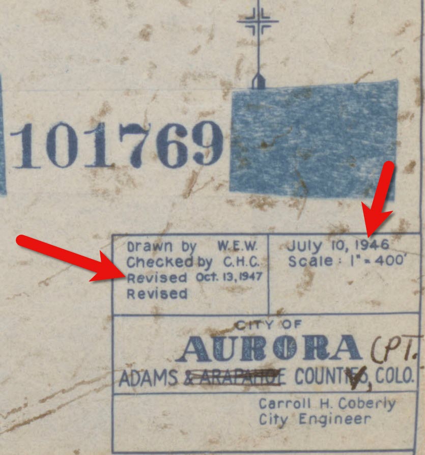
Look for the map title, description, legend and census stamps typically found in one of the corners. In this example (see image) from Aurora, Colorado the map used was originally created by the city engineer in 1946 and was revised in 1947.
1950 census map of Aurora, Colorado (Source: National Archives)
Following the end of World War II, the United States was growing at a quick pace in 1950. This is particularly true of the newly emerging suburbs. Therefore, if your ancestors built a new home in a new development in 1949, don’t be surprised if you don’t see the street on the 1950 census ED map. However, rest assured that the maps still hold value for your family history as they provide many interesting and unique details about the area surrounding your ancestors’ homes.
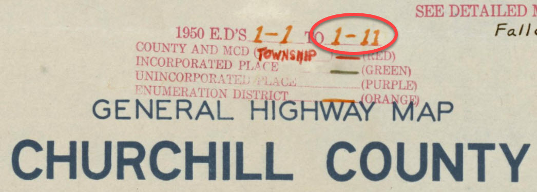
Each map was stamped with a small legend where the meaning for each of the colored lines drawn could be indicated. From my random sampling of 1950 census maps across the United States it appears that the coloring coding was consistent as follows:
Red = Township
Green = Corporate Limits/Ward
Orange = Enumeration District
Expect to see errors, inconsistencies and omissions in the maps. The more rural the area the more likely the map was compiled from several sources by the Census Bureau cartographers. This compilation created more opportunity for errors, and often used older maps.
Source: National Archives
The Meaning of Census Enumeration District Numbers
A census enumeration district number is made up of two numbers separated by a dash. The first number (in this example: 1) represents the county/region. The second number represents the area within the county that could be covered by an individual census enumerator within the amount of time provided for taking the census, about 2-4 weeks. The official start of the 1950 US Federal Census was April 1, 1950.
Census enumeration district (ED) numbers on a 1950 census map.
How to Find 1950 Census Maps
Some 8,000 census maps have been digitized and are available at the National Archives. However, the National Archives website can be challenging to navigate. I recommend using the Unified 1880-1950 Census ED Finder Tool at Steve Morse’s website.
1. Go to https:/stevemorse.org
2. In the menu in the upper left corner hover over US Census and in the secondary menu click Unified 1880-1950 Census ED Finder
3. Select the state from the first drop-down menu.
4. Next select the county.
5. Then select the city.
6. You will then see many enumeration district links listed. In order to find the right one for your ancestor’s home, enter the house number and select the street from the next drop-down menu. Don’t worry about directional parts of the address like west or east unless they are offered in the list of street names.
7. As soon as select the street name, the list of ED numbers should be reduced. In this example we are down to three.
8. To further reduce the possible ED numbers, we can select Cross or back street on same city block. If you’re not sure what the neighboring streets are, click the see Google Map This will plot the address you entered into Google Maps where you can then find the closest cross street, and the next streets over. If the address is not precisely marked on the map, check the address that appears in the Google Maps search box.
In my case, the One-Step tool didn’t allow me to specific W. Arcade, so Google Maps just gave me the general area, and not the address. By adding the W. to the address and pressing enter on my keyboard Google Maps was able to precisely plot the location. Now we can make note of the closest cross street (ex. N. Center), the street north of the address (E. Monterey Ave.) and the street south of the address (W. Noble St.)
9. Head back to the Unified 1880-1950 Census ED Finder page and enter each nearby street (you can enter multiple.) This should reduce the ED numbers one. This is the ED that includes your ancestor’s address.
How to Find 1950 Census Maps
1. Make note of the ED number, and then go back and click the button that says See ED Maps for ____________ County. You could have clicked this button without going through the process of locating the ED number, but the ED number makes it much easier to find your ancestor’s home street on the map. This number will also assist you in being able to find your ancestors in the 1950 census before it is indexed.
2. You will now be on the Viewing 1950 Enumeration District Maps in One Step Re-enter the city from the drop-down menu.
3. Click the Get ED Map Images You will receive two links. The first link is Links to NARA viewer will take you to the page on the National Archives website which includes all of the information about the map and the record hierarchy. Source citation information can be gathered from this page.
5. Click the second link called Direct links to jpegs on NARA server. This will take you to the image by itself as hosted on the National Archives website. I find this the easiest way to save the full resolution image to my computer hard drive. On my PC I right-click on the map and select Save Image As.
This page is also important if you want to use this image in another program such as Google Earth. The URL for this page is the direct URL to the image. Notice that it ends in .jpg. This means that it is the image alone, and this link can be used to create a custom map overlay in Google Earth. You can see an example of a custom map overlay in my video Create a Family History Tour with Google Earth Pro at the 06:13 mark.