Thousands of Sanborn Fire Insurance maps and a national Civil War burial database are among new genealogy records online. Also: newspapers in Florida, Hawaii, Illinois, Louisiana, and Pennsylvania; vital records for Idaho, Utah, and Washington; Catholic parish records for the Archdiocese of Boston; Maine cemetery plans; New Hampshire Civil War records and New York passenger arrivals.
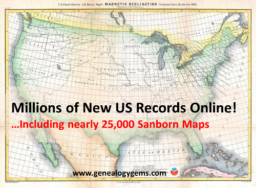
Breaking news! The Library of Congress has put online nearly 25,000 additional Sanborn Fire Insurance Maps–and more are coming! Over the next three years, more will be added monthly until all 50 states are covered from the 1880s through the 1960s.
Sanborn maps show detailed information about neighborhoods, buildings, roads and more for thousands of towns in the U.S. and beyond. A sizable collection of pre-1900 Sanborn maps are already online at the Library of Congress (use the above link). Watch the short video below to learn more about them. The full-length class is available to Genealogy Gems Premium Members.
Civil War burials. Ancestry.com’s new database, U.S., Civil War Roll of Honor, 1861-1865, lists over 203,000 deceased Civil War soldiers interred in U.S. cemeteries. “Records in this database are organized first by volume and then by burial place,” says the collection description. Entries “may contain the name of soldier, age, death date, burial place, cemetery, rank and regiment.”
Newspapers. We’ve noticed the following new digital newspaper content online recently:
Florida, Illinois, Pennsylvania: Newspapers.com recently added or updated newspaper content for the following newspapers (with coverage shown): Chicago Tribune (1849-2016), Fort Lauderdale News (1911-1991), South Florida Sun Sentinel (1981-2017) and the Morning Call [Allentown, PA] (1895-2017). (With a Newspapers.com Basic subscription, you can see issues through 1922; a Publisher Extra subscription is required to access issues from 1923 onward.)
Hawaii: Newspaper content has been recently added to the Papakilo Database, an online archive of The Office of Hawaiian Affairs. The collection currently contains nearly 12,000 issues from 48 different publications, with a total of 379,918 articles. Coverage spans from 1834 to 1980.
Louisiana: A New Orleans feminist newspaper is now available online at Tulane University’s digital library. An online description says: “Distaff was the first and only feminist newspaper published in New Orleans….Distaff served as a forum for women’s voices in politics, activism, and the arts….A preview issue was published in 1973 and the newspaper continued to be published until 1982. There was a hiatus in publication from 1976-1978.”
Maine cemetery plans. “Many Maine cemeteries have plans originally created courtesy of the Works Progress Administration, which reside at the Maine State Archives,” states a recent post at Emily’s Genealogy Blog at the Bangor Daily News website. The post advises us that all of them–nearly 550–are now viewable online at DigitalMaine.com (search for WPA cemetery plans). “These plans are great for locating veterans; some graves are coded by the war of service,” advises the post. “With such an item in hand one could also visit the appropriate town clerk and locate a civilian’s burial as well, I should think.” Thanks for that tip, Emily!
Massachusetts Catholic church records. The New England Historic Genealogical Society (AmericanAncestors.org) has added 13 new volumes to its browse-only collection, Massachusetts Roman Catholic Archdiocese of Boston Records, 1789-1900. “This addition, drawn from the collections of St. James the Greater in modern-day Chinatown, includes the largest volume we’ve scanned yet–1,035 pages,” says an NEHGS announcement. The collection description states that an index is being created and will be available to site members in the future.
New Hampshire Civil War records. The free site FamilySearch.org has added about 25,000 indexed names to its collection of New Hampshire, Civil War Service and Pension Records, 1861-1866. The collection contains an “index and images of Civil War enlistment papers, muster in and out rolls of New Hampshire Regiments and pension records acquired from the New Hampshire state archives.”
New York passenger lists. FamilySearch.org has added nearly 1.2 million indexed names to the database, New York Book Indexes to Passenger Lists, 1906-1942. According to the collection description, names are taken from “books of indexes to passenger manifests for the port of New York. The indexes are grouped by shipping line and arranged chronologically by date of arrival.”
Utah birth certificates. Nearly 33,000 names have been added to an existing FamilySearch database, Utah, Birth Certificates, 1903-1914. “This collection consists of an index and images to birth certificates acquired from the Utah State Archives,” says the site. “The records are arranged by year, county, and month within a numerical arrangement by box and folder number. Many of these volumes have indexes at the beginning or end.”
Sanborn maps are a rich resource for genealogy–but they’re just one kind of map that can lead to genealogical gems! Lisa Louise Cooke teaches tons of strategies for using maps to chart your family history in her Genealogy Gems Premium video series. Discover these for yourself with a Genealogy Gems Premium website membership.
Thanks for sharing this great news on Sanborn maps and more with your genealogy friends!
Disclosure: This article contains affiliate links and Genealogy Gems will be compensated if you make a purchase after clicking on these links (at no additional cost to you). Thank you for supporting Genealogy Gems!
Show Notes: Discover Sanborn Fire Insurance maps with Julie Stoner of the Geography and Map Division of the Library of Congress. Learn the best search strategies, how to download the Sanborn maps for free, and hidden online resources! Sanborn maps are an invaluable tool for family history because they provide an up-close look at the places where your ancestors lived.
(This interview has been minimally edited for clarity.)
Lisa: Today we’re talking about Sanborn fire insurance maps and how we can use them for genealogy. They’re available at the Library of Congress. Here to tell us more about that is Julie Stoner. She’s a reference specialist in the geography and map division of the Library of Congress.
Julie: Thanks so much, Lisa. Happy to be here.
I adore the Sanborn fire insurance maps because they give us such a unique perspective and view of our ancestors’ world.
What are Sanborn Fire Insurance Maps?
Start us off and tell us exactly what are Sanborn fire insurance maps?
Julie: The Sanborn fire insurance maps are a uniform series of large scale maps. They date starting from about 1867, though, they mainly start in the 1880s, and they run mostly through the 1950s. There are some from later dates as well.
It was a company started by a man named D.A. Sanborn. He was drawing these maps at a building level to sell to fire insurance companies so that they could then assess how much to charge people for the fire risk of their building. We use them for a lot more things today than they were originally intended for because they show the building level details of a city.
We have over 12,000 cities and towns represented. Some smaller towns may only have a few sheets. But the larger cities may have multiple volumes. They would go back and create a new map every 10 or 15 years or so. Therefore, you can really see how a city changed over time and how the buildings changed over time, and how a neighborhood was built. These maps can be used for all sorts of things now.
Lisa: I love the fact that they have such detail and are really unique. There really aren’t any other maps quite like these, are there?
Julie: It’s true. We do have other maps, like real estate atlases, and things like that of maybe a few cities, here and there, like Washington D.C. or New York. We have land ownership maps, but nothing of quite this scale or detail.
Sanborn Fire Insurance Maps Online Collection
Lisa: Let’s talk about the scale of the map collection. At the Library of Congress you have the physical map collection, and then there’s the collection that we can access online. Tell us a little bit about the scope of the collection? And does it vary whether we’re online or in person?
Julie: It does vary a bit because of copyright restrictions. As I said, we have about 12,000 different cities and towns represented, that equals over 700,000 map sheets. So, that’s a that’s a lot of sheets of maps. And a few years ago, the library, in conjunction with a third party, took on a project to scan all of the public domain Sanborn maps. Public domain means that there are no copyright restrictions on those maps. So that included anything published before 1922 at that point. Then anything published before 1964, in which the copyright wasn’t renewed. The library took on this project to scan all those, and those are completed and are all online on our website and can be downloaded.
That copyright date is now a rolling date. This means that there are now maps between 1923 and 1926 that are public domain that we haven’t scanned yet, and we are working to get those scan to get those online. And as soon as new maps come into the public domain, we hope to process them and upload those when that happens. So, a very large chunk of the Sanborn maps are online. But, if they are not, you can always come and see them in person as well, because we do have the physical copies.
Sanborn Map Resolution
Lisa: You mentioned that the part that the part of the collection that is in the public domain is available online. And they’re downloadable. Are those pretty high-resolution maps, so that we’ll be able to use those in our own genealogy projects?
Julie: For sure! They are definitely high resolution. The library scans them at the highest resolution that we can and so there’s actually a variety of files that you can download. We have JPEG images, which are a bit lower quality but are good for something like PowerPoints or computer screens. And then we have our TIFF files, which are the largest high-resolution files which have. These are a good size for printing.
Lisa: I know that the online collection, which I think most of our folks would be interested in accessing from home easily, is at the Library of Congress at the loc.gov website at https://www.loc.gov/collections/sanborn-maps. Tell us a little bit about what we’ll find there on the website.
Fire Insurance Map Research Guide at the Library of Congress
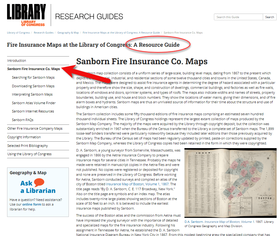
Julie: Sure, so that link that you said is a landing page for our digital images. Let’s start with the fire insurance map research guide that we have that is about our fire insurance maps in general, not just the Sandborn maps. There are a few other companies though Sanborn took those over in time. They became pretty much became the only one.
On the research guide page, there’s a large section on the left side of the page that says Sanborn Fire Insurance Company Maps. If you click on that, you will find a number of links to help you with your research of the Sanborn Fire Insurance Company maps.
The Research Guide at the Library of Congress
How to Search for Sanborn Maps
I want to point out the easiest way to find the maps. Under the searching for Sanborn Maps tab you will see some information including a link to our Sanborn Fire Insurance Map Checklist. This is the easiest way to find the maps that you’re looking for. It will take you to our fire insurance map index. And this is the easiest way to search for maps.
It’s so large that it can be a little overwhelming. This checklist is taken from a 1981 publication produced by the library that lists all of the Sanborn maps that we have in our collection. While the library has the largest collection of Sanborn maps in the world, we do not claim to have every one ever made. We are missing some. For example, if you found a map at your historical society that is not on this list, it just means that we don’t have it in our physical collection. Not that it doesn’t exist.
You can search by state at the Map Index. If you click on U.S. from the drop-down menu, you’ll find all the states. Scroll through and pick your state. I live in Virginia and I was born here, so I will search for Virginia. I will then see a list of hyperlinks with all of the cities available with Sanborn maps in the collection. Scroll through here and click on the city of interest. For example, if you want to click on Richmond you will get the list of Richmond maps here at the library. It’s a table and on the far left side you will see the date of the volume. And then you will see the number of sheets in that volume. Other geographic areas included sometimes in larger cities. The Sanborn Map Company would pick some areas farther outside the city to include in that volume, perhaps a few sheets. You’ll see a column called Comments which is mostly about the physical binding of the maps your library. And then a column called Website. If you click on the website link it will take you to the digital images.
Why are there multiple dates on Sanborn maps?
And just one other note about the date. If you look at the date, sometimes it can look a little confusing because you’ll see two dates listed. For example, volume 1924 through April 1950. So what’s happening here is that starting in the mostly the 40s and 50s, the Sanborn Map Company, decided it was faster, instead of making an entirely new map to cut and paste over an old map. So, this 1924 date is the face of the map. The 1950 date is the last time that they updated it. So, it’s really showing a 1950 era Richmond, but they’re just using that base map of 1924.
Downloading Sanborn Fire Insurance Maps
When you click through to these digital images, we can download them. Click on an image and you will see in the center of the screen the map that you can scroll in and out of, and then at the bottom underneath the image, you’ll see the download link. You’ll find that there are several options for JPEG images, a GIF file, and then the high resolution tiff file. It’s pretty great. We’re very happy that a lot of these are now online for researchers to use from outside of Washington, DC.
What do the colors and symbols mean on Sanborn maps?
Lisa: And when you look at these maps, there’s a lot of detail. There’s color coding, and all kinds of markings. Do you have resources on the website to help people interpret the map?
Julie: Sure we do. The best method first is to look at the first page of a volume. If you zoom in you will see that there is a map key. It’s a box usually at the top or the bottom of the sheet. That is going to show you what the colors and the symbols in each volume mean.
Different cities have different unique characteristics, and the Sanborn Map Company would map those. So, not every map is going to have every symbol. The key at the front is a really good way to see what specifically applies to that volume.
For example, pink typically means brick. Yellow typically means it was made out of frame, or wood. Green can change. I’ve seen it as cement, I’ve seen it as special, not exactly sure sometimes what that means. The colors indicate the type of building materials, and then you will see what the hash marks or the circles or the x’s mean, in various buildings. There are a lot of abbreviations that the Sanborn Map Company uses as well. D typically stands for dwelling, S for store.
If you want to see an entire list of the symbols, we have a great resource back on our research guides page. Go back to the research guide to the Interpreting Sanborn Maps section on the left. That’s going to tell you a lot more about the colors, the symbols, things like that.
If you go to the Internet Resources, under Websites, there’s a list called Sanborn Map Abbreviations and Legendcreated by Environmental Data Resources, who are the copyright holders of the Sanborn maps. They’ve created this great PDF that shows the most common abbreviations and symbols used to the Sanborn fire insurance maps. It’s pretty comprehensive.
Sanborn Fire Insurance Map Search Strategies
Lisa: That’s a fantastic resource! If we do the search and we don’t see the town that we have in mind in that list, is there another way or any other way to search to figure out if it is part of a bigger map? Perhaps it’s just too small of a town to have its own map?
Julie: That’s a great question. If it’s a really small town and you don’t see it on the list, the other thing you can do is search back on the index page. The main index page under the full text field. For example, there might be a few sheets of a smaller town on a bigger city. You can search for that in the all full text fields. That will search the other geographic location that we saw, like in Richmond. So say if we typed in Manchester, and we did a search for that. You would see that it’s here as well under Richmond, as well as its own city. So, you can see that maybe it had earlier sheets here in Richmond. If you don’t find it in the search, and you don’t find it in the search fields, and if you don’t find it in the list, then it’s likely that one was not made at that town. Unfortunately that does happen. A lot of small cities and towns just don’t have them sometimes.
Searching for counties and regions in Sanborn maps
Lisa: Well, that brings up another question. Are these always sorted by town or city? Or might we even see a county or even some other kind of regional area described in a map?
Julie: That’s a great question. You do sometimes see counties, I can think of an example off the top my head if you go to California, for example. If you scroll down to Los Angeles, you’re going to see that you have the city of Los Angeles, but then you also have Los Angeles County. That’s going to cover some of the county areas that are outside of the city itself. Typically they’re covering things like factories or industrial areas, or things of that nature, but you never quite know.
Another example would be in New Jersey. If you go to New Jersey, and scroll down to New Jersey coast which includes several different seaside towns. This would be an example of when you might want to do the full text search if you didn’t find it in the list. For example, New Jersey Coast includes Longbranch, and Monmouth Beach, etc. All of these volumes are kind of scattered down the coast.
I like to say that, for every rule for Sanborn maps, there’s an exception. It would be worth perusing that list just to see what other gems are out there are maybe very close by areas that would be worth taking a look at, even if we do find our cities listed or in a search.
The Sanborn Fire Insurance Map Index
Lisa: I can imagine there was a lot of effort that went into the indexing part of this collection, just getting all these cities and counties and everything listed. Was that work that the Library of Congress had to do? Or was that given to you by the company who now owns the copyright on Sanborn? And does it include anything besides a geographic place such as for example, any map with a saloon or any map with a particular feature?
Julie: That would be pretty amazing! Unfortunately, no, we don’t have anything that would list every saloon ever found, though, if somebody wanted to do that project, we’d be happy to take that.
This list was created by the Library of Congress in 1981, and we’ve added to it as we gained new material. The library is always looking for Sanborn maps that we don’t have in our collection. And when we find them, we do try and acquire them and then add them to our index. So, this particular list was created by staff at the library in 1981.
Lisa: What made me think of that question was I know that the David Rumsey collection out at Stanford is now working with and experimenting with a special type of OCR to pull that kind of text off maps. It’s amazing to see what technology might be able to do for us in the future.
Sanborn Map GIS Project
Julie: It is amazing what technology could do. And you’re right, there is a great project going on right now called machine reading maps that is experimenting with pulling the text out of the Sanborn maps to then create new products out of that.
We also have a new GIS project. GIS is geographic, geographic information systems. It’s basically putting information on a map so that you can see it and comprehend it at a glance.
One of the problems that we were having with our Sanborn maps, especially for our very large cities, like New York, LA, Chicago, is that there are so many volumes covering that city, and people would want to know where their exact address was. Well, there are, let’s say, seven or eight volumes of New York City. Which volume includes that address, right? So, we’ve created what we’re calling the Sanborn Atlas Volume Finder. You can find the link on our resource guide page. Click the link and you will see a map of the country. It’s going to pinpoint our current volume blinders.
We are hopefully going to be making more as we go. But basically, the first map is an index of what we have. Tight now we just have Los Angeles, Chicago and Detroit. We’re working on getting Washington DC and New York City out.
But say, for example, you’re interested in a map of Detroit, or an address in Detroit. If you click on Detroit on the pink pin, you can then click on the Sanborn volume finder. That’s going to take you to the Detroit map. It’s going to show you exactly what areas are covered in Detroit. It’s going to show you the extent of the Sanborn maps for the different years that it was mapped in Detroit.
If you look on the left side of the screen you’ll see the legend. This is a range of years for each set of maps that was created. You might see 1884 to 1896 and then 1897 to 1899. You can click the years on and off. So, if you just wanted to know the earliest maps of Detroit, you can see where it was mapped. And you can enter your address in the upper right corner of the screen. That’s going to pinpoint for you the address. Then when you click on it, it’ll tell you the volume where you’ll find the map, and a link that’ll take you to the digital images. So you don’t have to guess which volume your address is in anymore. It will tell you whether the digital images are available, or if the map is not available online, you can contact us to learn more about it.
Lisa: What an amazing tool. It’s exciting to think that will continue to expand particularly for these really big cities where like you said it, it’s like a needle in a haystack with the addresses.
Julie: Yes, there are a lot of volumes for some of these cities. It can be really difficult without expert knowledge how to find your address. We feel like this is really going to help researchers in diving deeper into the Sanborn maps and really finding what they’re looking for.
Accessing Offline Sanborn Fire Insurance Maps
Lisa: You mentioned that sometimes you’re going to see that it is not available online. That might be a copyright issue or something else. Explain to us a little bit about what our options are for getting access to a map that might only be available in person the Library of Congress. How might we go about the in person visit, or making a request online to get a copy?
Julie: It’s the geography and map division policy that we will not scan or send items that are possibly under copyright protection. In the case of the Sanborn maps, if they were renewed or after 1964 then they are copyrighted, so we can’t send those electronically to you. You can make an in person visit to the Library of Congress reading room. We’re open Monday to Friday 8:30 to 5:00, and we will pull out anything you want to see.
Another option is that these volumes have all been scanned in black and white by ProQuest, a subscription database. Those are all scanned in black and white. A lot of universities and public libraries subscribe to the ProQuest database. Go to your public library and ask if they subscribe to the ProQuest database. If they do, you can see them there, and you can download them. However, those are black and white, so that’s a little bit not as helpful sometimes if you’re looking for building construction, and things like that.
There is also on our research guide page, under Internet Resources a link called the Union List of Sanborn Maps. This is a list compiled by the University of California at Berkeley of other institutions that have Sanborn maps other than the Library of Congress. So if, for example, you are in California, and you can’t make it to the library, you can see if other institutions also have those physical copies that you could go to that institution to see.
Lisa: I’m familiar with ProQuest. Do you happen to know, is there one place where you can look up and see which libraries subscribed to ProQuest? Or is that just too much to ask?
Julie: I think you would have to do that individually by library. I’ve never seen a master list. But I find that librarians are usually very helpful people. So, if you called your local library or university library, I’m sure librarians there could tell you help you track it down.
The Growth of the Sanborn Map Collection
Lisa: So it this indeed a growing database? And do you continue to get both stuff that can go online as well as maps that will just be available in person?
Julie: We are always looking for maps that we don’t have here in our collection. Usually, most of those are going to be more recent, like 1950s, 1960s and 1970s maps. The library gained most of our early collection from copyright deposit. It used to be that you had to send in a physical copy of something for to get it copyrighted and that’s how our collection was built. We are still always looking for new updated ones that we don’t have. It is a growing collection. I wouldn’t say that we’re receiving them every day or anything. But when we do find them, and we do like to acquire them.
Final Thoughts on Sanborn Maps
Lisa: Wonderful. Well, before I let you go, you are the guru when it comes to the Sanborn Fire Insurance Maps over at the Library of Congress. Anything else that we should really know about, or look for as we’re working with these Sanborn maps?
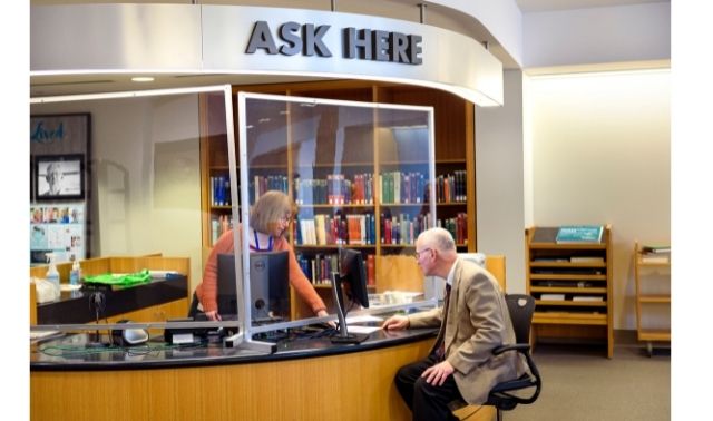
Julie: That’s a good question. First, I want to say that we always welcome questions to our division. On the left of the research guide, or on our main library of congress homepage, there’s a link that says Ask a Librarian, and you’re welcome to send us any questions that you have, that we haven’t answered on our research guide, or that you’re confused about. We’re always happy to answer questions.
The Sanborn maps are a fantastic resource for doing genealogy, for finding out more about the town you lived in, and the buildings that were there, and the types of buildings. A lot of the buildings will say what was in them, for example, a candy shop or a hat shop or whatnot. So, they’re a great resource to just find out more about the town. There’s always more to learn about them. I’m still learning about things that I didn’t know about Sanborn maps, years later.
Lisa: Julie, thank you so much for coming and sharing this terrific collection, and giving us such a unique view of the places where our ancestors may have lived. I’m sure you’ll be getting many inquiries through Ask the Librarian.
Julie: Yeah, dive in, reach out. We’re here to help.
Lisa: thank you so much for joining us here today.
Julie: My pleasure. Thank you.
Citing Sanborn Maps
Julie: The Library simply requests an attribution to the Library and the Geography and Map Division when publishing material from its collections, the format of the citation is up to you.
In this episode, we’re focusing on early Virginia genealogy.
In our first segment, I’ve invited a professional genealogist to join us to help pave the way for tracing our ancestors back to Virginia just prior to the Revolutionary War. Jeri Satterwhite-Dearing specializes in early Virginia research in her work as a professional genealogist with Legacy Tree Genealogists. In this podcast episode she explains some of the biggest challenges you’ll face when researching early Virginian ancestors, the records you should be looking for, and some of the best resources.
In the second segment, I’ll cover a list of the best websites for Virginia Genealogy.
Fort Wayne, Indiana is the home of the second largest free genealogy library in the country. Make your plans to visit today. Learn more at https://www.visitfortwayne.com
Formerly known as Virginia Heritage, this website is a “consolidated database of finding aids that provides information about the vast array of manuscripts and archival materials housed in Virginia and West Virginia.”
From the website: “Part of the online presence of the Library of Virginia, the state archives and reference library. The Library maintains vast and varied collections of print materials, manuscripts, archival records, newspapers, photographs and ephemera, maps and atlases, rare books, and fine art that tell the history of the commonwealth and its people.”
From the website: “The Virtual Jamestown Archive is a digital research, teaching and learning project that explores the legacies of the Jamestown settlement and “the Virginia experiment.” As a work in progress, Virtual Jamestown aims to shape the national dialogue on the occasion of the four hundred-year anniversary observance in 2007 of the founding of the Jamestown colony.”
Beginning Swedish genealogy can be daunting. But don’t let language barriers or unfamiliar naming traditions deter you! Check out these getting-started tips from an expert at Legacy Tree Genealogists.
This guest post comes from Paul Woodbury, a Senior Genealogist with Legacy Tree Genealogists. He’s an internationally recognized genetic genealogy expert and his varied geographical interests include Scandinavia. Thanks, Paul!
Many people avoid Swedish research because they don’t speak the language and because the names change every generation–like from Ole Olsson to Ole Nilsson to Nils Pehrrson. Despite these barriers, Swedish research can be relatively simple, fun, and successful for several reasons.
1. You can “read” many records without reading Swedish.
Particularly in late 18th and 19th century records, you don’t need in-depth Swedish language skills to make exciting discoveries. Swedish church records of the time were kept in tables and were largely composed of names, dates, and residences. Records include those of:
Birth and christening (födelse och döpte)
Marriage and engagement (lysning och vigsel)
Death and burial (död och begravning)
Moving-in lists (inflyttade) and moving-out lists (utflyttade)
Clerical examination (“husförhörslängd”)–more on these below.
Dates were frequently recorded in number formats according to the European system (dd-mm-yyyy). As a result, researchers can learn a great deal from Swedish documents with little knowledge of the Swedish language. For the few additional words you may need to learn, consider reviewing this list of words commonly found in Swedish documents available through FamilySearch.org.
2. Family events are summarized in Swedish clerical examinations.
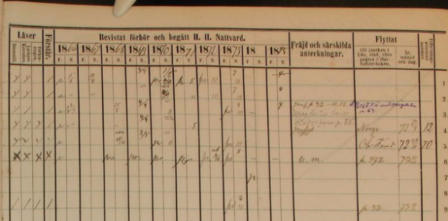
The clerical examination or “husförhörslängd” can act as an index to important family events. Beginning in 1686, each parish was required to keep a household examination for each household. Many early records don’t survive, but copies of these records exist for many parishes in Sweden after about 1780. As part of the household examination, parish priests of the Swedish Lutheran church were required to visit with the members of their parish at least once yearly and test them on their knowledge of the catechism.
Typically, these registers document a family over the course of 5-10 years. They not only include information about the family’s religious duties, but additional information regarding migration, family structure, residence and important family events. If a child was born, he or she was added to the clerical examination, and the birth date and christening date were noted. If an individual or a family moved within the parish, a note was made in the clerical examination with a reference to the page number of the family’s new residence. If they moved out of the parish, the date they left was often recorded along with the number of their entry in the moving-out books. The dates of deaths, confirmations, marriages, vaccinations and communions were also recorded. If you are lucky, additional notes might comment on crimes, physical characteristics, occupations, punishments, social standing, economic status, or other life events with references to pertinent records.
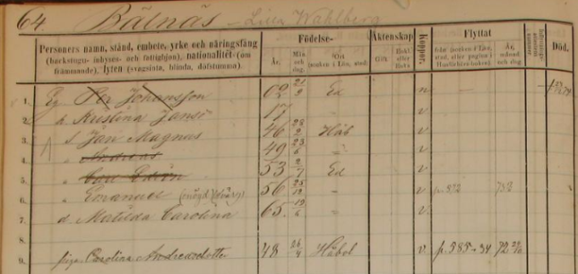
ArkivDigital, Dals-Ed (P) AI:15 (1866-1875), clerical examination, household of Per Johansson, Image 74 / page 64, https://app.arkivdigital.se, subscription database, accessed July 2017.
The above Household Clerical Examination in Dals-Ed Parish in Älvsborg covers 1866-1875 and shows the household of Per Johansson on the farm of Lilla Wahlberg in Bälnäs. The document provides birth dates and places for each household member. It shows that Per’s son, Andreas, moved to Norway in 1872. Another son, Emanuel, moved within the parish but returned after just a month. Among other notes on the document, we learn that Emanuel only had one eye and that he was a dwarf.
3. Many Swedish records cross-reference each other.
Clerical examinations reference other church records, such as those of a child’s birth or a couple’s marriage. But the reverse is also true: birth, marriage, death and migration records frequently reference household examinations. Birth records might list the page number of the child’s family in the household examination. Marriage records indicate the corresponding pages of the residences of the bride and the groom. Death records identify the residence of the deceased. Moving-in and moving-out records frequently report the corresponding page numbers of the farm where a migrant eventually settled or the parish from whence he came.
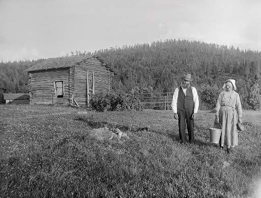
The yeoman farmer Ollas Per Persson and his wife Greta at a hut in Dalecarlia. Photograph by: Einar Erici, c1930. Wikimedia Commons image, Permission granted Swedish National Heritage Board @ Flickr Commons.
Most clerical examination buy medication for anxiety volumes include an index of farms and residences within the parish. In the case of some larger parishes and cities, local genealogical societies have sometimes indexed all individuals in the volume by name. When researching in multiple volumes, note the farm or residence of your ancestor in the previous record and then search the index of residences near the front or end of the next clerical examination volume. Usually, this will narrow your search to just a few pages out of the book rather than the entire volume.
4. You can trouble-shoot record gaps.
Even when an ancestor’s record trail turns cold, recent publications and indexes created by active Swedish genealogical societies make it possible to pick up the trails of elusive ancestors in earlier and later records. Even if these records do not list the specific pages of interest, they may still provide the reported residences, which can then be located in the clerical examination records.
Occasionally, an ancestor might have moved in a year for which migration records are not currently available, or they might have moved to a larger city with many parishes. Other times, their migration may not have been noted, or jurisdiction lines may have been redrawn resulting in the formation of a new farm and residence. In these cases it may be difficult to continue tracing an ancestor’s record trail. One strategy to overcome these situations is to search the clerical examinations by reported birth date. The birth dates or ages of Swedish ancestors are recorded in many of their records. If you are browsing through large collections, consider searching by birth date rather than by name. Since birth dates were often recorded in their own unique column and are more immediately recognizable than names, this may expedite your search. Even if these strategies still yield no results, searches in indexes may help to uncover an elusive ancestor’s record trail.
5. There are some excellent Swedish indexes and databases online.
In recent years, online indexes and databases have made Swedish genealogical research simpler than ever:
Sveriges Släktforskarföbund has compiled an index of Swedish death records from 1900 to 2013. It includes the birth dates, birth places, names, maiden names, death dates, residences at time of death, age at time of death, and if the individual was married or widowed, the index will also include the date of marriage or the date of death of their spouse. If they were not married, it will indicate their civil status. Click here to purchase the database (the price is in Swedish krona; do a Google search such as currency converter sek to usd to see the price in your country’s currency). (A related Ancestry.com database is entitled “Births from the Swedish Death Index” and only includes names, maiden name, birth dates and birth places of the individuals in the index.)
As you can see, Swedish genealogical records from the late 1700s and 1800s can be fairly easy to read, detailed and full of cross-references. It’s often possible to trace a Swedish ancestor in every year of their life from birth to death! So don’t let language or patronymics (naming traditions) frighten you away from exploring your Swedish family tree.
Help is available when you need it
Have you hit a brick wall that could use professional help? Or maybe you simply don’t have the time for research right now? Our friends at Legacy Tree Genealogists provide full-service professional research customized to your family history, and deliver comprehensive results that will preserve your family’s legacy.
Disclosure: This article contains affiliate links and Genealogy Gems will be compensated if you make a purchase after clicking on these links (at no additional cost to you). Thank you for supporting Genealogy Gems!
 Sanborn maps are a rich resource for genealogy–but they’re just one kind of map that can lead to genealogical gems! Lisa Louise Cooke teaches tons of strategies for using maps to chart your family history in her Genealogy Gems Premium video series. Discover these for yourself with a Genealogy Gems Premium website membership.
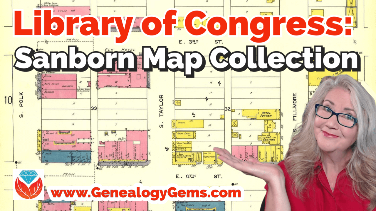


 This guest post comes from Paul Woodbury, a Senior Genealogist with