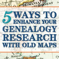
Our ability to find our ancestors is rooted in two important pieces of information: the locations where they lived and the time frames in which they lived there. This means that old maps are essential to our genealogy research.
The good news is that there is an abundance of free digitized old maps available online. One of the best resources is the David Rumsey Map Collection website. There you will find over 100,000 free digitized historic maps. These maps span the globe and centuries. They are perfect for bringing geographic perspective to your family tree.
Elevenses with Lisa Show Notes
In this episode 36 of my free webinar video series Elevenses with Lisa I’ll show you how to navigate this ever-expanding free website. Watch the video and then follow along with the show notes in this article. Here you’ll find answers to questions such as:
What’s the best way to find maps at David Rumsey’s map website?
What is the difference between the search tools (Luna Viewer and MapRank Search)?
What are the advanced search techniques for finding the old maps?
How can I download maps at DavidRumsey.com?
Is it OK to use the maps from DavidRumsey.com in my family history projects?
Rumsey Historical Maps in Google Earth
As we discussed in Ways to Use Google Earth for Genealogy (Elevenses with Lisa episode 12) there are approximately 120 Rumsey old maps available for free in Google Earth. You can find them in the Layers Panel under Gallery. Each map is already georeferenced as an overlay for you.
Click image to watch the video and read the article on ways to use Google Earth for genealogy
You can also create your own overlays in Google Earth using Rumsey Maps or digitized maps from other sources. I cover this step-by-step in chapter 16 of my book The Genealogist’s Google Toolbox.
Best Strategies for Finding Free Old Maps
Once you’ve exhausted the few hundred old maps in Google Earth, head to the David Rumsey Map Collection website. Rumsey’s collection includes over 150,000 map, over 100,000 of which have been digitized and are available for free on his website.
Copyright and Use Permission
You will probably be anxious to use these wonderful old maps in a variety of ways. The Rumsey website provides clear direction on copyright and use permission. Go to: DavidRumsey.com > Home Page > About > Copyright and Permissions.
The good news is that generally speaking, you are free to download and use the digitized maps for your own personal use.
The Best Way to View the Maps
There are several ways to view maps:
The Luna Viewer: Browse and search 100,000+ maps
The GeoReferencer: Help georeferenced maps, compare maps overlays
MapRank Search: Browse & search 6000 maps by time & place
Google Earth: 120 maps in the Layers panel, 140 can be added
Google Maps: 120 maps included
Second Life: View some in 3 dimensions and at a huge scale. Location: Rumsey Map Islands. Includes a welcome center with hundreds of maps, and a 600 meter tall map cylinder showing hundreds of maps.
The Collections Ticker: Pop-out distraction!
Insight Java Client: Downloadable workspace
Of this list, the best two tools to user are:
The Luna Viewer: Browse and search 100,000+ maps
MapRank Search: Browse & search 6000 maps by time & place
I will show you how to use each. Note that in these examples we will be using a computer to search the site rather than a mobile device or tablet.
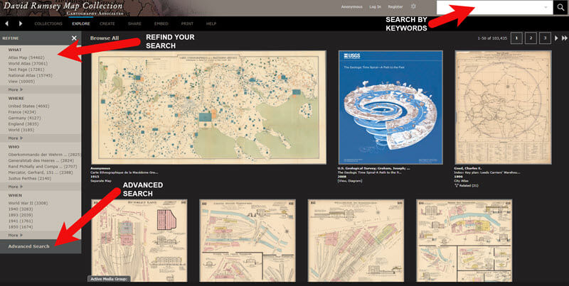
The Luna Viewer: How to browse & search the maps
In the main menu under View Collection select the Luna Viewer. Under Luna Viewer click the Launch Luna Viewer button.
The Luna Viewer at David Rumsey Map Collection
Tips for keyword searching:
In most cases it helps to start with a fairly broad search to see the full range of available maps
Be cautious with abbreviations. “MN” does not return “Minn” or “Minnestota”.
Advance search provides you with the use of full Boolean operators like “and,” “or,” “greater than,” “contains,” and others.
After a search, to return to the full collection, click on “show all” under the search button.
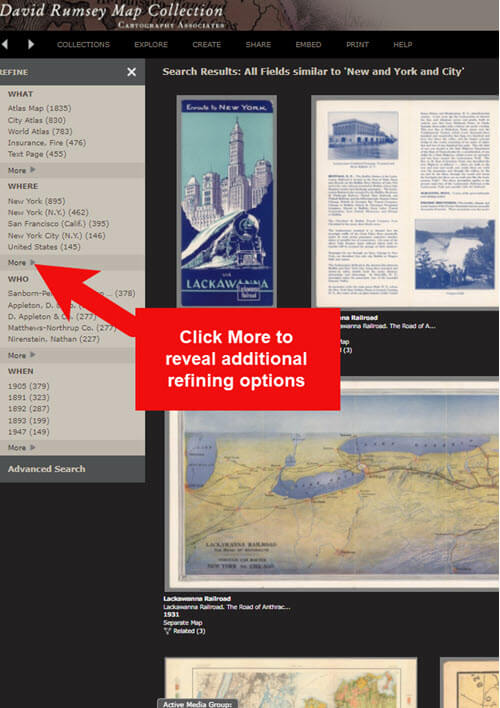
Let’s look at an example of using the keyword search in tandem with the Refine column. If you search for New York City, you will be searching all of the data associated with the maps. Since many maps may have been published in New York City, you will likely see many maps for other areas. You can improve this search by going to the Refine column and under Where clicking on New York City.
The Refine column will show you the first five options in each category (What, Where, Who, When). Click More to reveal all of the additional refining options in that category.
Click More to see all refining options in the Luna Viewer
From the returned results, click a map to view it.
You can select multiple items in the Refine column to filter more narrowly. Remove a filter by clicking it under Remove at the top of the Refine column.
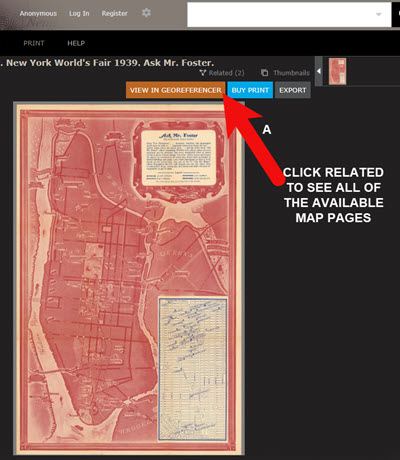
Like genealogical records, old maps may include several pages. Look above the blue BUY PRINT button to see the number of Related maps. In my example of a map of the 1939 World’s Fair in New York City, there were two map pages available. Click Related to display all of the available pages.
Click the Related link to view all related map pages.
DavidRumsey.com Advanced Search
The Advanced Search feature can be found in two locations:
Inside the search box – click your mouse in the box and select Advanced Search from the drop-down list
At the bottom of the Refine column on the left side of the screen.
Advanced Search gives you more control over how you search. Let’s look at an example by searching for Sanborn fire insurance maps.
Searching for Sanborn Fire Insurance Maps
The David Rumsey Map Collection website includes many Sanborn Fire Insurance maps. These maps were created for insurance purposes and provide an incredible amount of detail about individual buildings and dwellings in a given neighborhood.
I recommend using the Advanced Search feature to search for these maps. This is because over the years the name of the company as publisher changed.
How to Find Sanborn Maps:
Click on Advanced Search at the bottom of the Refine column
In the “find all of these words” section, click Fields and select Publisher
Type in Sanborn
On the results page, go to the Refine column and Who click More
There are at least six variations of the Sanborn publishing name.
Old Map books and atlases often include valuable historical text often called historical sketches. You can find these using the Advanced search. Search for the exact phrase Historical Sketch. Run this search and then in the Refine column under Where select an area of interest.
How to Download Maps from DavidRumsey.com
Click the map from the results list
On the map’s dedicated page click the EXPORT button at the top of the page.
Select the appropriate size from the drop-down list. (Larger maps may take a few moments to download)
Typically the maps will download to the Downloads folder on your computer
Tips for Selecting Download (Export) Map Size: Save space on your computer and future headaches by selecting the correct size map for your use. If you plan on using the map to create an overlay or create a nice large print, select the largest size possible ( I recommend at least Extra Large for creating map overlays in the Google Earth.) This will ensure that the map doesn’t appear fuzzy when you Zoom in. High-resolution is also recommended when printing. For example, if you plan on including the map in a book about your family’s history (for personal use, not for resale) a high-resolution map will print crisp and clear. Maps for use on the web or something like a PowerPoint presentation would be fine at lower resolutions.
MapRank Search at DavidRumsey.com
The MapRank Search “app” at the David Rumsey Map Collection website allows you to browse & search 6000 maps by two important criteria: Time & Place.
There are two ways to find the MapRank Search:
In the main menu under View Collection click MapRank Search. Scroll to the bottom of the page and click the Launch MapRank Search
Scroll to the bottom of the home page until you see Featured App – MapRank Search, and click the Launch MapRank Search
How to Find Maps Using MapRank Search:
Start with entering the location name in the search box (in the upper right corner) and click the Find a Place
The location will appear on the modern-day map. The old maps that match the location will appear in the column on the right, prioritized starting with the map that most closely matches what you searched.
Below the modern-day map, move the time slider levers to narrow in on the desired time frame.
Note that the old maps in the results column will change based on the specified time frame.
Broaden the location if desired by zooming out a bit on the modern-day map. Note that the results list will change as you zoom.
Hover your mouse over a map in the results list and notice that a reddish-brown box will appear the selected map and will also appear on the modern-day map. This indicates the area of the map that the old map covers. This will aid you in selecting the map that will suit your needs.
Click a map from the results list and it will open in a new browser tab, although some maps will appear as an overlay on the modern-day map. In that case, click the Luna Viewer button to go to the page where the map can be downloaded.
How to Compare Modern-day Maps with Old Maps
Whether you have found the map by searching with the Luna Viewer or the MapRank Search you will eventually find yourself on the page where the single map is displayed. On the left is the source information.
In the upper right corner of the screen click the View in GeoReferencer button. You will be taken to a page where you can view the old map overlayed on the modern-day map. In the upper right corner move the slider to make the old map transparent so that you can compare between the two maps.
Recap: Comparing the Two Best Search Tools at DavidRumsey.com
Luna Viewer: – 100,000 maps
– Search, then refine
– Sometimes glitchy interface
MapRank Search: – 6000+ maps
– More control with time slider & map
– Map results list ranked by closest coverage
Live Chat Q&A: Answers to Your Questions About David Rumsey Maps
One of the advantages of tuning into the live broadcast of each Elevenses with Lisa show is participating in the Live Chat and asking your questions.
From Megan: What is the difference between Google Earth and My Maps? From Lisa: Google Earth is a free software download. This is where I create what I call family history tours. They are a collection of data points and media that come together as a research tool and storytelling tool. My Maps are created in Google Maps. I prefer creating in Google Earth because it offers more tools and options, and it’s where I keep all my mapping work.
From Gwynn: Heard in the past Java Client might have security holes has this been fixed? From Lisa: Read more about the latest on Java Client at the website’s FAQ page.
From GeneBuds: Must set up account to use Luna Viewer? From Lisa: No, you don’t have to have an account to use the Luna Viewer. “Registering for an account allows you to save your work and preferences, search external media, create Media Groups and Presentations, customize your settings, create annotations, and upload your own content.” As I mentioned in the video, I prefer to do all my work in Google Earth.
From Gwynn: Sanborn Fire Maps: Where do I find the Key to the symbols? Are they the same from year to year or do they change? From Lisa: Here’s the main resource page for Sanborn maps at the Library of Congress. You will find specific information about interpreting the maps including Keys and Colors here.
From Karen: If you are specifically looking for plat maps for our US farmers would you put the word plat in the search field? From Lisa: I would use the Advanced Search and enter the word plat in the “Find all these words” box. Click the plus sign to add an additional “Find all these words” field and type in the name of the location. If that doesn’t deliver the desired result, omit the location and just search on the word plant. Then, on the results page, go to the Refine column and under Where click More. Then you have a nice list to browse. You might spot a map that includes your location. TIP: When you find a result, be sure to check the Related number at the top of the page so that you didn’t miss any additional pages of the map.
From Mark: Lisa and Bill, is the intro music something that you all wrote? From Lisa and Bill: No, it’s by a talented musician named Dan Lebowitz. Our goal this year was to learn to play it ourselves 🙂 We’re glad you love it as much as we do!
Join me for Elevenses with Lisa, the online video series where we take a break, visit and learn about genealogy and family history. (scroll down to watch the video)
Genealogy Consultation Provides a Strong Hypothesis
My 45-minute consultation with a genealogy expert Kate Eakman at Legacy Tree Genealogists broke things wide open on my Irish family lines and gave me the information and resources I needed to make all of the progress I shared in this episode. It’s the best investment I’ve made in my genealogy in a long time. They have experts in all areas. Learn more about how easy it is to book a consultation here.
After my consultation I needed to update my research plan and get to work collecting more genealogical evidence.
Let’s quickly recap what happened when I started working on my brick wall last week in episode 18:
Margaret Lynch’s death certificate said her parents were James Scully and Bridget Madigan.
Her obituary said she was born in Limerick Ireland.
There was one couple by those names in Limerick, having children and the right time. There is a gap in the records where Margaret should be.
Her husband Michael Lynch dies in Stillwater MN. St. Michael’s Catholic church. Found their marriage record in Stillwater. It was a large booming town, and a good place to focus. The Lynch family had a farm across the river in Farmington, Wisconsin.
My research question: Was this couple we found, James Scully and Bridget Madigan, who married in Kilcolman, Limerick, Ireland in 1830, the parents of Margaret Scully?
What Kate Eakman of Legacy Tree Genealogists helped me do in my 45-minute consultation:
Become acquainted with a variety of excellent Irish research websites
Located the indexed marriage record for James and Bridget
Located the original marriage record for James and Bridget
Located the indexed baptismal records for all of the children who had James and Bridget listed as their parents.
A Genealogy Research Plan for Collecting Evidence
After the consultation I developed a new research question: Are the children that we found records for in Ireland the siblings of my Margaret Lynch?
My research plan included:
Verify if there were any other couples by the names James Scully and Bridget Madigan married in Ireland, particularly in the time from of circa 1830. (Location of source: RootsIreland.ie)
Search in the U.S., starting in the area where Margaret lived, for each child. I’m looking for records that name these same parents, and show the child at an age that correlates with the baptismal date.
I identified several sources I believed would help me accomplish my goals.
Marriage Records – I conducted a search for James in Bridget in all counties in Ireland. I discovered that the couple Kate found during my consultation is the only couple in the RootsIreland database with those names married in Ireland. This gives me more confidence that I have the correct couple.
U.S. Records – Armed with the names and ages of the children of James and Bridget, it was time to return to America. I needed to search U.S. records to see if any of the children came to America (perhaps living near Margaret) and if these parents were named.
Records to look for:
U.S. Federal Census (Ancestry, FamilySearch), and State Census (Minnesota Historical Society, Ancestry, FamilySearch)
Death records (Minnesota Historical Society, FamilySearch.)
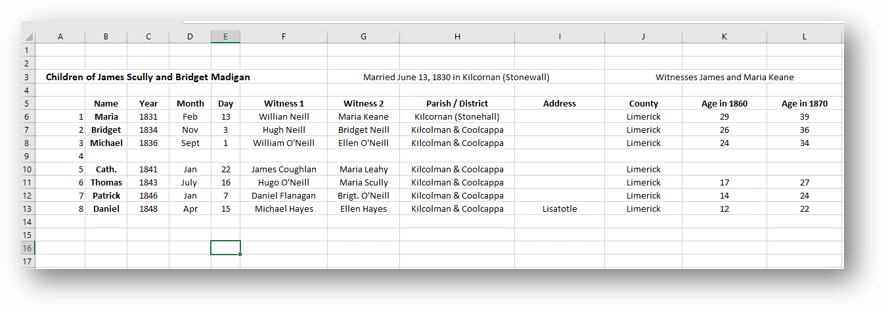
Before I began my search I created an excel spreadsheet to capture the information. I included columns for what their ages should be in each census.
Using a spreadsheet to track my findings.
Now I was ready to start the genealogical hunt!
U.S. Census
Search each sibling one at a time in the census.
Focus on Washington Co., Minnesota (marriage and death location for Margaret & Michael Lynch)
Move on to Polk County Wisconsin, and greater Wisconsin.
Search both U.S. Federal Census & State Census
Top locations identified for this search: Ancestry.com, Familysearch.org, Minnesota Historical Society
Results:
Found individuals matching the sons in Stillwater and Baytown (Washington County)
Found Bridget Scully (Mother) living with various sons in various census records.
Immigration years listed for some of Margaret’s siblings.
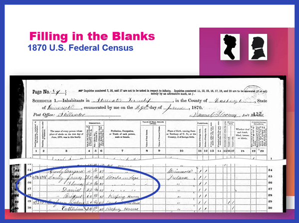
Found in the 1870 U.S. Federal Census: James, Thomas, Daniel and Bridget.
I created folders for each sibling marked MAYBE and collected the records on my hard drive.
Learn more about hard drive organization in Elevenses with Lisaepisode 8.
Searched FamilySearch and the Minnesota Historical Society for a death record for each son.
Found Thomas and James.
James Scully and Bridget Madigan listed as parents
Ages matched
Next step: order the death certificates
Newspapers
Next I searched the Minnesota Historical Society website for newspapers.
Results:
170+ articles
Two obituaries for Bridget Scully! (8 children, immigration year, husband died in Ireland implied)
Found James Scully working with his brother and his obituary
Research Tip: Look at a map and identify nearby towns and larger cities. Expand your search to these areas.
I found a James Scully in the 1860 census with Bridget and his brothers, and working with Thomas in many newspaper articles.
Bridget’s obituary said she came to America with 8 children. 7 had baptismal records in Ireland. James and Margaret were not found in the baptismal records but were confirmed in U.S. records to have the same parents. That would be a total of 9 children. It’s possible one of the daughters that have not yet been found in U.S. records may have died in Ireland prior to their leaving for America.
I then combed back through my Lynch binder – I might spot something that I marked as unsure, or that might jump out at me now that didn’t 20 years ago.
Found History of the St. Croix Valley I had photocopied a section. Names Daniel Scully (who I have since found in the census, newspapers and death records) and says his parents are James Scully and Bridget Madigan!
Looked the book up in Google Books. It’s fully digitized. Now I can extensively read and search it.
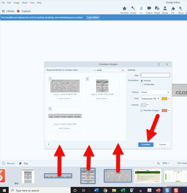
Tech Tip: Clip and combine newspaper clippings with SnagIt software
Clipping and saving newspapers poses a unique challenge for genealogists:
Clipping a small portion of a very large digital newspaper page can result in a low resolution file.
If you clip an article you don’t always capture which newspaper and issue it came from
Articles often continue in different locations on the page or pages, making it impossible to capture the entire article in one image.
I use SnagIt software to clip my newspaper finds. I can then save them to Evernote or archive them on my hard drive. SnagIt can save your clippings in wide range of file types and can even clip video. You can get your copy of SnagIt here. It’s a one time fee and download – no subscription! (Thank you for using my link – it financially supports this free without any added expense to you.)
How to combine multiple clippings with Snagit:
Clip the paper title and date
Clip the article
Clip any additional applicable sections of the article
In the SnagIt menu under Image click Combine Images
Drag and drop the clippings into the desired order
Click the Combine button
Save the combined image: In the menu File > Save As (you can select from a wide variety of file types)
Research Tip: Using Street Addresses in Google Earth
When you find a street address, whether in a newspaper, city directory, census or other genealogical record, use it to find the location in the free Google Earth software program. You can then save an HD quality image of the location.
How to find a location in Google Earth (on a computer):
Type the address into the search field in the upper left corner
Click the Search button
The map will automatically “fly to” the location and a pin will mark the general spot.
Hover your mouse pointer in the upper right corner of the to reveal the navigation tools. Click the plus sign to zoom in closer.
How to view the location with Street View:
Zoom in relatively close so that the street and buildings are distinctly visible.
Just above the zoom tool you will find the Street View icon (the yellow “peg man”). Click on the icon and drag it over the street in front of the building / location. Don’t release your mouse. It may take a second or two for the blue line to appear indicating that Street View is available in that location. If no blue line appears street view is not available.
When the blue line is visible, drop the Street View icon directly onto the blue line in front of the location you want to view. by releasing your mouse. If you miss the line and the picture looks distorted, click the Exit button in the upper right corner and try again.
Once on Street View, you can use your keyboard arrow keys to navigate. You can also click on further down the street to move forward that direction.
How to save an image of a street view location:
Position yourself in the best view of the desired location using your mouse and keyboard arrow keys as described above.
In the toolbar at the top of the screen, click the Image icon (it looks like a portrait-oriented page, near the printer icon)
A Title and Description box will appear at the top of the screen beneath the toolbar. Click it and type in a title and description for your image if desired.
You can adjust the size (resolution) of the image you will be saving by clicking the Resolution button above the title box.
When you’re ready to save the image to your hard drive, click the Save Image
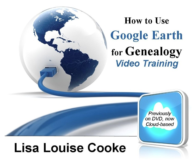
Learn more about using Google Earth for genealogy in Elevenses with Lisaepisode 12.
Order the video training series at the Genealogy Gems Store featuring 14 exclusive step-by-step video tutorials. The perfect companion to the book The Genealogists’s Google Toolbox by Lisa Louise Cooke.
After a week of post-consultation research:
Question: Who were the parents of Margaret Scully born in Limerick Ireland on approximately July 9, 1840?
Answer: James Scully and Bridget Madigan, married in Limerick, Ireland June 13, 1830. (Though I feel confident about this, I still have additional records I want to find in order to further solidify this conclusion.)
Question: In what Parish was Margaret Lynch born?
Answer: Most likely Kilcolman based on the baptismal locations of her siblings.
My Next Research Steps:
Browse search through the baptismal parish records at NLI 1839-1842 for Margaret, and 1834-1836 for James Scully.
Look for marriages of Margaret’s female siblings, and family burials.
(Contact St. Michael’s church, Stillwater, MN.)
Go through newspapers.com – there are several Minneapolis and St. Paul papers running articles from Stillwater.
Resume my search of passenger list records with the newly revised date of c. 1851.
Search for the death record of Bridget’s husband James at RootsIreland and NLI.
How to Book a Genealogy Consultation
My 45-minute consultation with a genealogy expert Kate Eakman at Legacy Tree Genealogists broke things wide open on my Irish family lines and gave me the information and resources I needed to make all of the progress I shared in this episode. It’s the best investment I’ve made in my genealogy in a long time. They have experts in all areas. Learn more about how easy it is to book a consultation here.
Learn More:
For more step-by-step instructions for using Google Earth read my book The Genealogist’s Google Toolbox available at the Genealogy Gems Store.
Recommended Genealogy Gems Premium Member Videos with downloadable handouts:
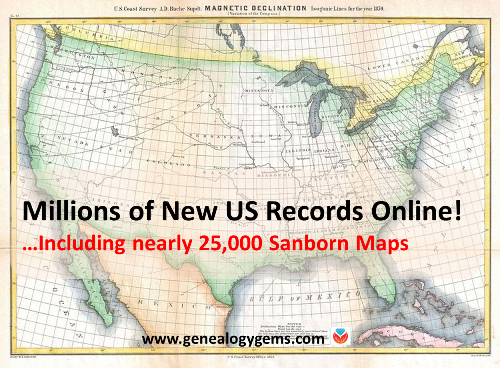
Thousands of Sanborn Fire Insurance maps and a national Civil War burial database are among new genealogy records online. Also: newspapers in Florida, Hawaii, Illinois, Louisiana, and Pennsylvania; vital records for Idaho, Utah, and Washington; Catholic parish records for the Archdiocese of Boston; Maine cemetery plans; New Hampshire Civil War records and New York passenger arrivals.
Breaking news! The Library of Congress has put online nearly 25,000 additional Sanborn Fire Insurance Maps–and more are coming! Over the next three years, more will be added monthly until all 50 states are covered from the 1880s through the 1960s.
Sanborn maps show detailed information about neighborhoods, buildings, roads and more for thousands of towns in the U.S. and beyond. A sizable collection of pre-1900 Sanborn maps are already online at the Library of Congress (use the above link). Watch the short video below to learn more about them. The full-length class is available to Genealogy Gems Premium Members.
Civil War burials. Ancestry.com’s new database, U.S., Civil War Roll of Honor, 1861-1865, lists over 203,000 deceased Civil War soldiers interred in U.S. cemeteries. “Records in this database are organized first by volume and then by burial place,” says the collection description. Entries “may contain the name of soldier, age, death date, burial place, cemetery, rank and regiment.”
Newspapers. We’ve noticed the following new digital newspaper content online recently:
Florida, Illinois, Pennsylvania: Newspapers.com recently added or updated newspaper content for the following newspapers (with coverage shown): Chicago Tribune (1849-2016), Fort Lauderdale News (1911-1991), South Florida Sun Sentinel (1981-2017) and the Morning Call [Allentown, PA] (1895-2017). (With a Newspapers.com Basic subscription, you can see issues through 1922; a Publisher Extra subscription is required to access issues from 1923 onward.)
Hawaii: Newspaper content has been recently added to the Papakilo Database, an online archive of The Office of Hawaiian Affairs. The collection currently contains nearly 12,000 issues from 48 different publications, with a total of 379,918 articles. Coverage spans from 1834 to 1980.
Louisiana: A New Orleans feminist newspaper is now available online at Tulane University’s digital library. An online description says: “Distaff was the first and only feminist newspaper published in New Orleans….Distaff served as a forum for women’s voices in politics, activism, and the arts….A preview issue was published in 1973 and the newspaper continued to be published until 1982. There was a hiatus in publication from 1976-1978.”
Maine cemetery plans. “Many Maine cemeteries have plans originally created courtesy of the Works Progress Administration, which reside at the Maine State Archives,” states a recent post at Emily’s Genealogy Blog at the Bangor Daily News website. The post advises us that all of them–nearly 550–are now viewable online at DigitalMaine.com (search for WPA cemetery plans). “These plans are great for locating veterans; some graves are coded by the war of service,” advises the post. “With such an item in hand one could also visit the appropriate town clerk and locate a civilian’s burial as well, I should think.” Thanks for that tip, Emily!
Massachusetts Catholic church records. The New England Historic Genealogical Society (AmericanAncestors.org) has added 13 new volumes to its browse-only collection, Massachusetts Roman Catholic Archdiocese of Boston Records, 1789-1900. “This addition, drawn from the collections of St. James the Greater in modern-day Chinatown, includes the largest volume we’ve scanned yet–1,035 pages,” says an NEHGS announcement. The collection description states that an index is being created and will be available to site members in the future.
New Hampshire Civil War records. The free site FamilySearch.org has added about 25,000 indexed names to its collection of New Hampshire, Civil War Service and Pension Records, 1861-1866. The collection contains an “index and images of Civil War enlistment papers, muster in and out rolls of New Hampshire Regiments and pension records acquired from the New Hampshire state archives.”
New York passenger lists. FamilySearch.org has added nearly 1.2 million indexed names to the database, New York Book Indexes to Passenger Lists, 1906-1942. According to the collection description, names are taken from “books of indexes to passenger manifests for the port of New York. The indexes are grouped by shipping line and arranged chronologically by date of arrival.”
Utah birth certificates. Nearly 33,000 names have been added to an existing FamilySearch database, Utah, Birth Certificates, 1903-1914. “This collection consists of an index and images to birth certificates acquired from the Utah State Archives,” says the site. “The records are arranged by year, county, and month within a numerical arrangement by box and folder number. Many of these volumes have indexes at the beginning or end.”
Sanborn maps are a rich resource for genealogy–but they’re just one kind of map that can lead to genealogical gems! Lisa Louise Cooke teaches tons of strategies for using maps to chart your family history in her Genealogy Gems Premium video series. Discover these for yourself with a Genealogy Gems Premium website membership.
Thanks for sharing this great news on Sanborn maps and more with your genealogy friends!
Disclosure: This article contains affiliate links and Genealogy Gems will be compensated if you make a purchase after clicking on these links (at no additional cost to you). Thank you for supporting Genealogy Gems!
Don’t miss the Bonus audio for this episode. In the app, tap the gift box icon just under the media player. Get the app here.
Get the Free Genealogy Gems Newsletter
The Genealogy Gems email newsletter is the best way to stay informed about what’s available with your Premium eLearning Membership. Sign up today here.
Library and Archives Canada, the Canadian national archive, holds original passenger arrival records. You can search a massive index to them on their website for free.
Canadian Passenger Arrival Lists: The Good and Bad News
There’s good news and bad news for those searching for Canadian passenger arrival lists.
The Bad News:
You won’t find a lot of Canadian passenger arrival lists before 1865. There are no comprehensive nominal lists of immigrants arriving prior to 1865 in Canada according to the Library and Archives Canada. Unfortunately, those lists didn’t generally survive.
Those that have can be scattered amongst various French and British collections.
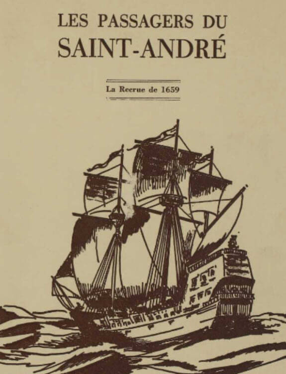
“Les passagers du Saint-André : la recrue de 1659” is among the French resources at the Library and Archives Canada.
Visit the Passenger Lists page at the Library and Archives Canada herefor details lists, years and microfilm numbers.
Good news:
You will be able to find a lot of records after 1865.
And the news gets even better. These records can easily be found online!
“The passenger lists are the sole surviving official records of the arrival of the majority of people accepted as immigrants in Canada,” says a Library Archives Canada webpage. “The passenger list is a list of immigrants arriving at an official port of entry on a particular ship on a given date.
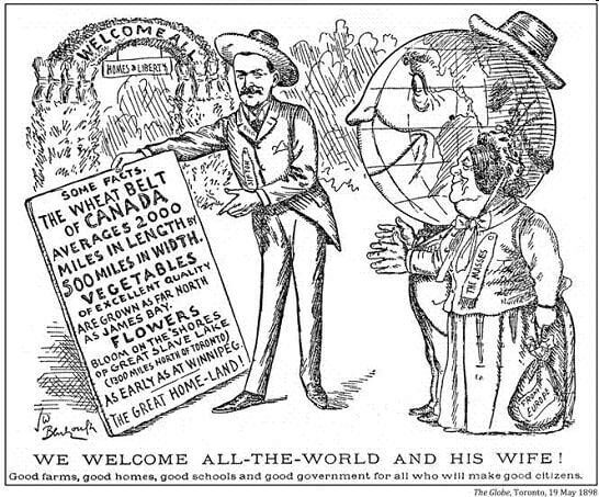
Newspaper advertising was used to attract immigrants to Canada
Information Found in Canadian Passenger Lists
Generally speaking, each manifest provides the following information:
the name of the ship
port(s)
date(s) of departure and arrival in Canada
names
ages
sex
professions or occupations
nationalities
destinations
The earlier lists aren’t always so detailed. But in some cases, other lists have information about the travelers’:
health
religion
previous travels to Canada
family members
and how much they carried in their wallets.
Where to Search for Canadian Passenger Lists 1865-1922
Start your search for free in the Passenger Lists, 1865-1922 collection at the Library and Archives Canada website.
The city of Quebec, the major arrival port for many years, is covered for nearly that entire time span.
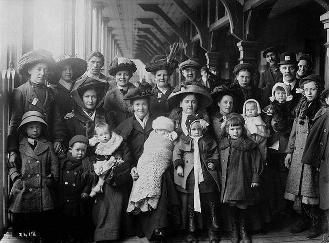
Quebec: Major Arrival Port in Canada
If you find it easier to search for these records in genealogy websites (so you can attach them to individuals in your tree), or if you’re specifically looking for passengers whose final destination was the U.S., check out these databases:


 Sanborn maps are a rich resource for genealogy–but they’re just one kind of map that can lead to genealogical gems! Lisa Louise Cooke teaches tons of strategies for using maps to chart your family history in her Genealogy Gems Premium video series. Discover these for yourself with a