Show Notes: The FamilySearch Wiki is like an encyclopedia of genealogy! It’s an invaluable free tool that every genealogist needs. However, many folks get frustrated when they try to search the Wiki. In this week’s video premiere I’m going to help you navigate with ease.
Video and Show Notes below
You’ll learn:
what the Wiki has to offer,
how to access the FamilySearch Wiki
how to navigate the FamilySearch Wiki effectively
and how to overcome the number #1 reason people get frustrated when searching the Wiki!
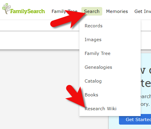
(00:42) There are two ways to access the FamilySearch Wiki. The first is to visit the website direction at https://www.familysearch.org/wiki. This will take you to the home page of the Wiki. Although you can sign into your free FamilySearch account on this page (in the upper right corner) it isn’t necessary in order to use it.
The second way to access the Wiki is to go to the FamilySearch website. You will need to log into your FamilySearch account or sign up for a free account if you don’t already have one. Once you’re signed in, then in the menu under Search click Research Wiki. This will take you to the same FamilySearch Wiki home page. However, you will see that you are signed in and able to use some of the additional features like participating in discussions, posting and creating watchlists.
On the FamilySearch website: Search > Research Wiki
Searching the Wiki by Location
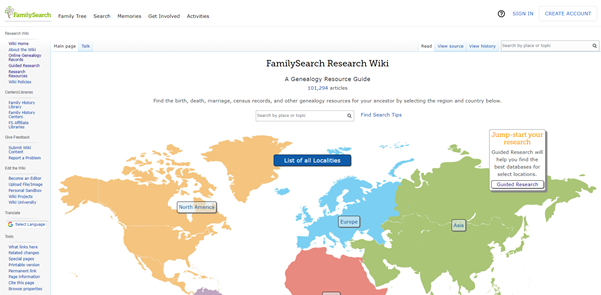
(01:21) On the home page, what you see a map of the world. This is a great way to search the Wiki because in genealogy, it’s really all about location. We need to know where geographically we want to search for ancestors, and from there we can narrow down the timeframe. Typically, you’ll have a sense of at least in which country you need to be researching. So, the map is typically the best way to start.
The FamilySearch Wiki Home Page
You’ll notice also on the home page, there is a search by place or topic search field. You could bypass using the map, and just start by typing in a place. If you do, you’ll notice that it starts to prompt you on the kinds of things that are commonly searched for. This could be kind of nice if you are really focused on a particular thing such as Italian census records. You can just start typing Italy and see if census is one of the prompts. If it is, simply click it and it will take you right there.
However, generally speaking, the map is the best way to search for records and information that is rooted in a location. Start by clicking the button for the continent, such as North America. Notice that if you go to click on the map itself, it isn’t an interactive map. You’ll need to actually click the button.
From there, select the county from the menu, such as United States, then drill down by state. This will take you to the Wiki entry for that state.
You’ll notice that the FamilySearch Wiki is a lot like Wikipedia. It’s like an encyclopedia of information. But the exciting part is that it’s genealogy specifically! This means you don’t usually have to worry about including the word genealogy in your searches.
Location-based FamilySearch Wiki Pages
Oftentimes, our research ends up taking us to a new location where the next set of great grandparents came from. If we’re not familiar with that location, let alone familiar with what’s available from a genealogical standpoint, that can pose a real challenge. You might be asking questions like when did they start recording birth records? Or did that state conduct a state census? Every state, every country, and every county has different types of records available.
Start your orientation over on the right-hand side of the wiki page. There you’ll typically find an overview box.
(04:15) This is a great place to quickly see what’s available here, and what you could dig into further. If you’re really new to research in this particular area, you might want to start with the guided research link. You may also see links to research strategies, and a record finder.
In the next section of the box you’ll find record types. This is going to be different depending on the area that you’re researching. For example, if they don’t happen to have any military records available you might not see that listed under record types. You should expect to see the most commonly used records included in the list. Click the link to the page for more information on that type of record. It will provide more details on record availability, and where you access the records.
Further down the box you’ll find links to background information on the area. It’s really easy to skim over this in excitement over records. But if you don’t want to get stuck at a brick wall, getting to know the place that you’re researching can make all the difference. Learning the background of an area can help you prepare the right questions to ask. It can help prevent you from looking for something that doesn’t exist or that wasn’t applicable to that area. You may find links to more reading, gazetteers and maps, migration patterns, periodicals, and the law. Understanding the law is going to help you understand why records were created, and who they affected. For example, if your ancestor was under 18 there might be certain records that don’t apply to them. Understanding the parameters of who was affected by the law will help guide you through the records themselves.
Next you’ll see cultural groups that you might expect to find in this area, and links to more specific information about researching them.
Under Resources you’ll find links to archives, libraries, societies, and the family history centers that are available in this particular area.
At the top of the main part of the page you’ll find the Getting Started section. Here you’ll find links to beginning step-by-step research strategies and some of the most popular records for that location such as vital records.
(08:35) You might be wondering who is putting this information together. Well, it starts with experts at the Family History Library in Salt Lake City. These are people who have worked the reference desks and found answers to thousands of patron questions.
Locating and Using the County Wiki Page
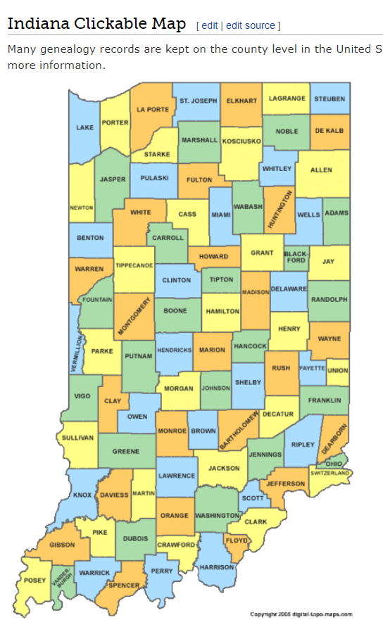
(09:22) Back on the state landing page scroll down further to the map of counties. Navigating by location is still important, even when we’ve narrowed it down to the state. Unlike the map on the homepage, you can hover your mouse over each county and click.
County map on the state wiki page
The county pages are where the real magic happens because many records such as birth, marriage, death, and court records are typically available at the county level. Here you’ll find out how to contact or visit the current county courthouse.
One of the most common questions new genealogists ask is “should I be looking at the county where the town is located today, or the county that it was when my ancestors lived there?” Counties certainly do change over time. The answer to the question is that we go to the county at the time that are ancestors lived in the area. In fact, the Wiki page provides the history, or genealogy, of the county. Look for Boundary Changes on the page.
Because these pages are often quite long and dense, use your computer’s Find on Page feature by pressing Control + F (PC) or Command + F (mac) on your keyboard. This gives you a nice little search box at the top of the page. Type in a keyword like Boundary and it will highlight all the locations on the page where the term appears. This is a great way to make quick use of the Wiki. This is also a good trick to use when you don’t see the record type or keyword that you’re looking for in the page’s table of contents. It may be called something else there, but if you search the page for your keyword, it should find it for you. An example of this is that you may not see Birth Records in the TOC because they list Vital Records. However, in the Vital Records section further down the page they definitely mention birth records.
Finding the Dates that Records Began
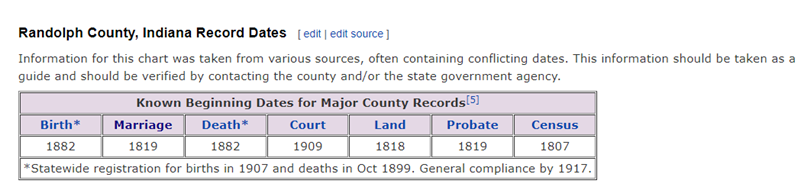
(14:45) Here’s another reason the wiki is so helpful, and it makes things go so quickly. Remember, we talked about that location is key, but also timeframe. Well, if we are looking for genealogical records, we don’t want to look for a record in this county before they actually started creating those records. The wiki typically provides a nice little chart on each county page showing then some of the most important civil records such as birth, marriage and death were first created.
County record dates at FamilySearch Wiki
Often times civil records began much later than church records. Sometimes you will see an asterisk indicating when statewide registration for these civil records began and then another date indicating when general compliance was enforced. All of this is guiding us to success in finding genealogy records, and it’s saving the headache of investing time looking for records that did not yet exist.
(17:42) Further down the page you’ll find links to places. These may link to town pages on the Wiki, but more likely they will take you to Wikipedia where this information already exists. There will be a small icon indicating that the link will open in a new tab and take you to another website.
Next you’ll likely see a Timeline section which gives you a sense of when the first people settled in the county and who those people were. Again, it provides you more context to better understand the records.
In addition to all these individual records, many of them linked over toFamilySearch, Ancestry or MyHeritage, we see Research Facilities. Why is that so important? Because not all records are going to be online. When we’ve exhausted online records and resources we need to go offline, and there are lots of resources here on the wiki to work with: county archives, family history centers in the local area, libraries, museums, and genealogical societies. The wiki provides contact information and links to their website where you may be able to see a listing of what they have onsite so you can plan your visit.
Other website links may take you sites like USGenWebwhich is a fantastic free genealogy website. It’s organized by location much like the FamilySearch wiki website. Drill down to the state and then the county. You may also see links to the State Archive, or the state’s Memory project, and, of course, the FamilySearch catalog.
How to Overcome the #1 Search Problem
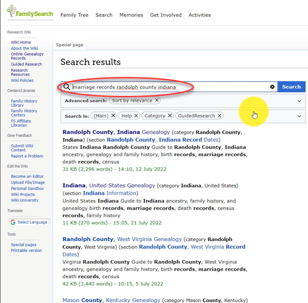
(22:01) The wiki really should be one of your first stops when you’re going to be starting research in a new area. Let’s wrap up with a quick conversation about the wiki’s search box. You could go ahead and put a topic in there. Many people will come in here and they’ll type in marriage records, Randolph, County, Indiana, and they will get a list of results. They don’t look as clear cut as Google results, and they may not all be on topic. This is where we can get lost. I think probably the number one reason why people give up on the wiki is they get these kinds of search results. They realize, wait a second, this isn’t even Indiana, it’s talking about Kentucky! Why am I getting all these? It can be frustrating.
The wrong way to search at the FamilySearch Wiki
This happens because we tried to do it ourselves, with our own keywords. Remember, like most search engines, they’ve indexed their content to make it searchable, so that means they’ve already decided how they want to talk about a particular topic. Rather than just addressing marriage record first, the wiki focuses on the location. Where is this marriage record? So, focus first on the place unless you are just looking for general information on a general genealogy topic such as genealogy software.
Pay attention to the pre-filled suggestions as you type because the wiki is going to suggest what it has in the format it has it. Again, you may want to first go to the country, state or county level page and then look for the record type.
What if you’re looking for marriage records but you don’t see them listed? Well, it might be that the word marriage isn’t the keyword the wiki uses. Or it might be that the type of record you’re looking for is a state or federal record. That’s another reason why the find on page feature (Ctrl + F) is so helpful. Don’t be discouraged if you don’t see what you want listed in the table of contents. It may just be a keyword issue. Let the work that they’ve already done in organizing their materials guide you. You’ll be more successful and also avoid frustration. The FamilySearch Wiki is just too good of a resource to miss.
Learn more about using Family Search at Genealogy Gems
Our ability to find our ancestors is rooted in two important pieces of information: the locations where they lived and the time frames in which they lived there. This means that old maps are essential to our genealogy research.
The good news is that there is an abundance of free digitized old maps available online. One of the best resources is the David Rumsey Map Collection website. There you will find over 100,000 free digitized historic maps. These maps span the globe and centuries. They are perfect for bringing geographic perspective to your family tree.
Elevenses with Lisa Show Notes
In this episode 36 of my free webinar video series Elevenses with Lisa I’ll show you how to navigate this ever-expanding free website. Watch the video and then follow along with the show notes in this article. Here you’ll find answers to questions such as:
What’s the best way to find maps at David Rumsey’s map website?
What is the difference between the search tools (Luna Viewer and MapRank Search)?
What are the advanced search techniques for finding the old maps?
How can I download maps at DavidRumsey.com?
Is it OK to use the maps from DavidRumsey.com in my family history projects?
Rumsey Historical Maps in Google Earth
As we discussed in Ways to Use Google Earth for Genealogy (Elevenses with Lisa episode 12) there are approximately 120 Rumsey old maps available for free in Google Earth. You can find them in the Layers Panel under Gallery. Each map is already georeferenced as an overlay for you.
Click image to watch the video and read the article on ways to use Google Earth for genealogy
You can also create your own overlays in Google Earth using Rumsey Maps or digitized maps from other sources. I cover this step-by-step in chapter 16 of my book The Genealogist’s Google Toolbox.
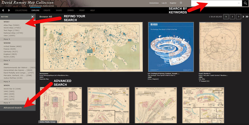
Best Strategies for Finding Free Old Maps
Once you’ve exhausted the few hundred old maps in Google Earth, head to the David Rumsey Map Collection website. Rumsey’s collection includes over 150,000 map, over 100,000 of which have been digitized and are available for free on his website.
Copyright and Use Permission
You will probably be anxious to use these wonderful old maps in a variety of ways. The Rumsey website provides clear direction on copyright and use permission. Go to: DavidRumsey.com > Home Page > About > Copyright and Permissions.
The good news is that generally speaking, you are free to download and use the digitized maps for your own personal use.
The Best Way to View the Maps
There are several ways to view maps:
The Luna Viewer: Browse and search 100,000+ maps
The GeoReferencer: Help georeferenced maps, compare maps overlays
MapRank Search: Browse & search 6000 maps by time & place
Google Earth: 120 maps in the Layers panel, 140 can be added
Google Maps: 120 maps included
Second Life: View some in 3 dimensions and at a huge scale. Location: Rumsey Map Islands. Includes a welcome center with hundreds of maps, and a 600 meter tall map cylinder showing hundreds of maps.
The Collections Ticker: Pop-out distraction!
Insight Java Client: Downloadable workspace
Of this list, the best two tools to user are:
The Luna Viewer: Browse and search 100,000+ maps
MapRank Search: Browse & search 6000 maps by time & place
I will show you how to use each. Note that in these examples we will be using a computer to search the site rather than a mobile device or tablet.
The Luna Viewer: How to browse & search the maps
In the main menu under View Collection select the Luna Viewer. Under Luna Viewer click the Launch Luna Viewer button.
The Luna Viewer at David Rumsey Map Collection
Tips for keyword searching:
In most cases it helps to start with a fairly broad search to see the full range of available maps
Be cautious with abbreviations. “MN” does not return “Minn” or “Minnestota”.
Advance search provides you with the use of full Boolean operators like “and,” “or,” “greater than,” “contains,” and others.
After a search, to return to the full collection, click on “show all” under the search button.
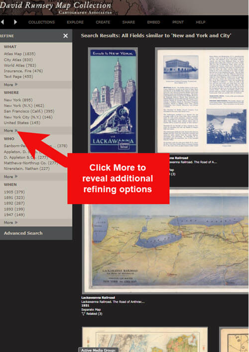
Let’s look at an example of using the keyword search in tandem with the Refine column. If you search for New York City, you will be searching all of the data associated with the maps. Since many maps may have been published in New York City, you will likely see many maps for other areas. You can improve this search by going to the Refine column and under Where clicking on New York City.
The Refine column will show you the first five options in each category (What, Where, Who, When). Click More to reveal all of the additional refining options in that category.
Click More to see all refining options in the Luna Viewer
From the returned results, click a map to view it.
You can select multiple items in the Refine column to filter more narrowly. Remove a filter by clicking it under Remove at the top of the Refine column.
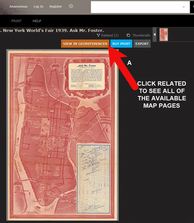
Like genealogical records, old maps may include several pages. Look above the blue BUY PRINT button to see the number of Related maps. In my example of a map of the 1939 World’s Fair in New York City, there were two map pages available. Click Related to display all of the available pages.
Click the Related link to view all related map pages.
DavidRumsey.com Advanced Search
The Advanced Search feature can be found in two locations:
Inside the search box – click your mouse in the box and select Advanced Search from the drop-down list
At the bottom of the Refine column on the left side of the screen.
Advanced Search gives you more control over how you search. Let’s look at an example by searching for Sanborn fire insurance maps.
Searching for Sanborn Fire Insurance Maps
The David Rumsey Map Collection website includes many Sanborn Fire Insurance maps. These maps were created for insurance purposes and provide an incredible amount of detail about individual buildings and dwellings in a given neighborhood.
I recommend using the Advanced Search feature to search for these maps. This is because over the years the name of the company as publisher changed.
How to Find Sanborn Maps:
Click on Advanced Search at the bottom of the Refine column
In the “find all of these words” section, click Fields and select Publisher
Type in Sanborn
On the results page, go to the Refine column and Who click More
There are at least six variations of the Sanborn publishing name.
Old Map books and atlases often include valuable historical text often called historical sketches. You can find these using the Advanced search. Search for the exact phrase Historical Sketch. Run this search and then in the Refine column under Where select an area of interest.
How to Download Maps from DavidRumsey.com
Click the map from the results list
On the map’s dedicated page click the EXPORT button at the top of the page.
Select the appropriate size from the drop-down list. (Larger maps may take a few moments to download)
Typically the maps will download to the Downloads folder on your computer
Tips for Selecting Download (Export) Map Size: Save space on your computer and future headaches by selecting the correct size map for your use. If you plan on using the map to create an overlay or create a nice large print, select the largest size possible ( I recommend at least Extra Large for creating map overlays in the Google Earth.) This will ensure that the map doesn’t appear fuzzy when you Zoom in. High-resolution is also recommended when printing. For example, if you plan on including the map in a book about your family’s history (for personal use, not for resale) a high-resolution map will print crisp and clear. Maps for use on the web or something like a PowerPoint presentation would be fine at lower resolutions.
MapRank Search at DavidRumsey.com
The MapRank Search “app” at the David Rumsey Map Collection website allows you to browse & search 6000 maps by two important criteria: Time & Place.
There are two ways to find the MapRank Search:
In the main menu under View Collection click MapRank Search. Scroll to the bottom of the page and click the Launch MapRank Search
Scroll to the bottom of the home page until you see Featured App – MapRank Search, and click the Launch MapRank Search
How to Find Maps Using MapRank Search:
Start with entering the location name in the search box (in the upper right corner) and click the Find a Place
The location will appear on the modern-day map. The old maps that match the location will appear in the column on the right, prioritized starting with the map that most closely matches what you searched.
Below the modern-day map, move the time slider levers to narrow in on the desired time frame.
Note that the old maps in the results column will change based on the specified time frame.
Broaden the location if desired by zooming out a bit on the modern-day map. Note that the results list will change as you zoom.
Hover your mouse over a map in the results list and notice that a reddish-brown box will appear the selected map and will also appear on the modern-day map. This indicates the area of the map that the old map covers. This will aid you in selecting the map that will suit your needs.
Click a map from the results list and it will open in a new browser tab, although some maps will appear as an overlay on the modern-day map. In that case, click the Luna Viewer button to go to the page where the map can be downloaded.
How to Compare Modern-day Maps with Old Maps
Whether you have found the map by searching with the Luna Viewer or the MapRank Search you will eventually find yourself on the page where the single map is displayed. On the left is the source information.
In the upper right corner of the screen click the View in GeoReferencer button. You will be taken to a page where you can view the old map overlayed on the modern-day map. In the upper right corner move the slider to make the old map transparent so that you can compare between the two maps.
Recap: Comparing the Two Best Search Tools at DavidRumsey.com
Luna Viewer: – 100,000 maps
– Search, then refine
– Sometimes glitchy interface
MapRank Search: – 6000+ maps
– More control with time slider & map
– Map results list ranked by closest coverage
Live Chat Q&A: Answers to Your Questions About David Rumsey Maps
One of the advantages of tuning into the live broadcast of each Elevenses with Lisa show is participating in the Live Chat and asking your questions.
From Megan: What is the difference between Google Earth and My Maps? From Lisa: Google Earth is a free software download. This is where I create what I call family history tours. They are a collection of data points and media that come together as a research tool and storytelling tool. My Maps are created in Google Maps. I prefer creating in Google Earth because it offers more tools and options, and it’s where I keep all my mapping work.
From Gwynn: Heard in the past Java Client might have security holes has this been fixed? From Lisa: Read more about the latest on Java Client at the website’s FAQ page.
From GeneBuds: Must set up account to use Luna Viewer? From Lisa: No, you don’t have to have an account to use the Luna Viewer. “Registering for an account allows you to save your work and preferences, search external media, create Media Groups and Presentations, customize your settings, create annotations, and upload your own content.” As I mentioned in the video, I prefer to do all my work in Google Earth.
From Gwynn: Sanborn Fire Maps: Where do I find the Key to the symbols? Are they the same from year to year or do they change? From Lisa: Here’s the main resource page for Sanborn maps at the Library of Congress. You will find specific information about interpreting the maps including Keys and Colors here.
From Karen: If you are specifically looking for plat maps for our US farmers would you put the word plat in the search field? From Lisa: I would use the Advanced Search and enter the word plat in the “Find all these words” box. Click the plus sign to add an additional “Find all these words” field and type in the name of the location. If that doesn’t deliver the desired result, omit the location and just search on the word plant. Then, on the results page, go to the Refine column and under Where click More. Then you have a nice list to browse. You might spot a map that includes your location. TIP: When you find a result, be sure to check the Related number at the top of the page so that you didn’t miss any additional pages of the map.
From Mark: Lisa and Bill, is the intro music something that you all wrote? From Lisa and Bill: No, it’s by a talented musician named Dan Lebowitz. Our goal this year was to learn to play it ourselves 🙂 We’re glad you love it as much as we do!
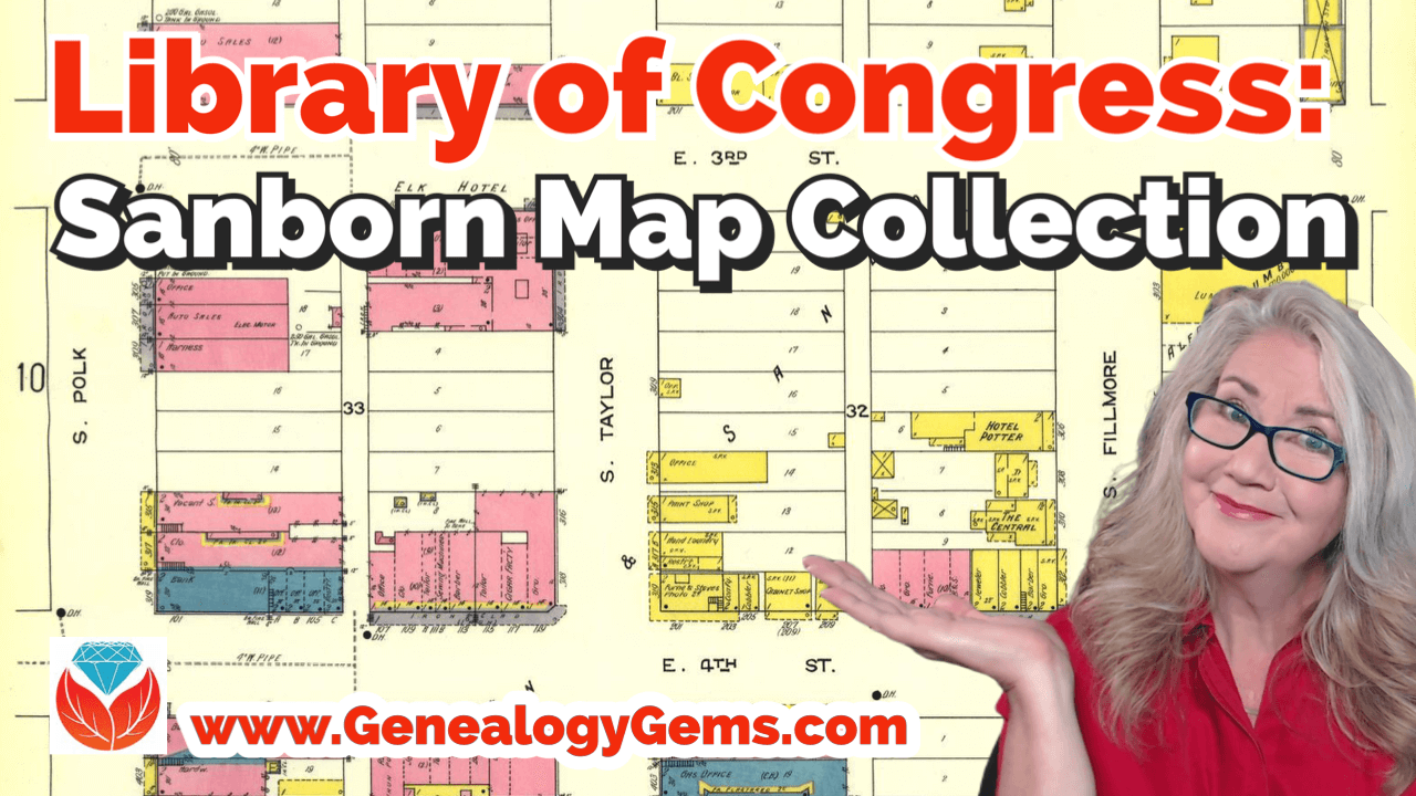
Show Notes: Discover Sanborn Fire Insurance maps with Julie Stoner of the Geography and Map Division of the Library of Congress. Learn the best search strategies, how to download the Sanborn maps for free, and hidden online resources! Sanborn maps are an invaluable tool for family history because they provide an up-close look at the places where your ancestors lived.
(This interview has been minimally edited for clarity.)
Lisa: Today we’re talking about Sanborn fire insurance maps and how we can use them for genealogy. They’re available at the Library of Congress. Here to tell us more about that is Julie Stoner. She’s a reference specialist in the geography and map division of the Library of Congress.
Julie: Thanks so much, Lisa. Happy to be here.
I adore the Sanborn fire insurance maps because they give us such a unique perspective and view of our ancestors’ world.
What are Sanborn Fire Insurance Maps?
Start us off and tell us exactly what are Sanborn fire insurance maps?
Julie: The Sanborn fire insurance maps are a uniform series of large scale maps. They date starting from about 1867, though, they mainly start in the 1880s, and they run mostly through the 1950s. There are some from later dates as well.
It was a company started by a man named D.A. Sanborn. He was drawing these maps at a building level to sell to fire insurance companies so that they could then assess how much to charge people for the fire risk of their building. We use them for a lot more things today than they were originally intended for because they show the building level details of a city.
We have over 12,000 cities and towns represented. Some smaller towns may only have a few sheets. But the larger cities may have multiple volumes. They would go back and create a new map every 10 or 15 years or so. Therefore, you can really see how a city changed over time and how the buildings changed over time, and how a neighborhood was built. These maps can be used for all sorts of things now.
Lisa: I love the fact that they have such detail and are really unique. There really aren’t any other maps quite like these, are there?
Julie: It’s true. We do have other maps, like real estate atlases, and things like that of maybe a few cities, here and there, like Washington D.C. or New York. We have land ownership maps, but nothing of quite this scale or detail.
Sanborn Fire Insurance Maps Online Collection
Lisa: Let’s talk about the scale of the map collection. At the Library of Congress you have the physical map collection, and then there’s the collection that we can access online. Tell us a little bit about the scope of the collection? And does it vary whether we’re online or in person?
Julie: It does vary a bit because of copyright restrictions. As I said, we have about 12,000 different cities and towns represented, that equals over 700,000 map sheets. So, that’s a that’s a lot of sheets of maps. And a few years ago, the library, in conjunction with a third party, took on a project to scan all of the public domain Sanborn maps. Public domain means that there are no copyright restrictions on those maps. So that included anything published before 1922 at that point. Then anything published before 1964, in which the copyright wasn’t renewed. The library took on this project to scan all those, and those are completed and are all online on our website and can be downloaded.
That copyright date is now a rolling date. This means that there are now maps between 1923 and 1926 that are public domain that we haven’t scanned yet, and we are working to get those scan to get those online. And as soon as new maps come into the public domain, we hope to process them and upload those when that happens. So, a very large chunk of the Sanborn maps are online. But, if they are not, you can always come and see them in person as well, because we do have the physical copies.
Sanborn Map Resolution
Lisa: You mentioned that the part that the part of the collection that is in the public domain is available online. And they’re downloadable. Are those pretty high-resolution maps, so that we’ll be able to use those in our own genealogy projects?
Julie: For sure! They are definitely high resolution. The library scans them at the highest resolution that we can and so there’s actually a variety of files that you can download. We have JPEG images, which are a bit lower quality but are good for something like PowerPoints or computer screens. And then we have our TIFF files, which are the largest high-resolution files which have. These are a good size for printing.
Lisa: I know that the online collection, which I think most of our folks would be interested in accessing from home easily, is at the Library of Congress at the loc.gov website at https://www.loc.gov/collections/sanborn-maps. Tell us a little bit about what we’ll find there on the website.
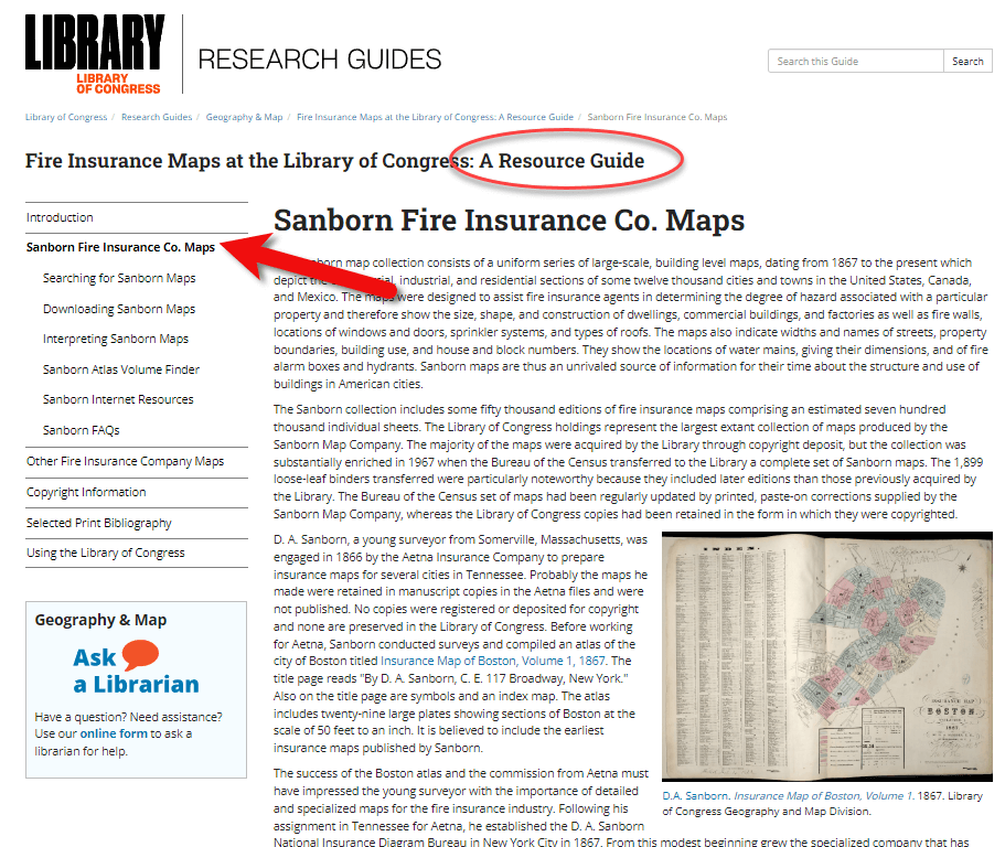
Fire Insurance Map Research Guide at the Library of Congress
Julie: Sure, so that link that you said is a landing page for our digital images. Let’s start with the fire insurance map research guide that we have that is about our fire insurance maps in general, not just the Sandborn maps. There are a few other companies though Sanborn took those over in time. They became pretty much became the only one.
On the research guide page, there’s a large section on the left side of the page that says Sanborn Fire Insurance Company Maps. If you click on that, you will find a number of links to help you with your research of the Sanborn Fire Insurance Company maps.
The Research Guide at the Library of Congress
How to Search for Sanborn Maps
I want to point out the easiest way to find the maps. Under the searching for Sanborn Maps tab you will see some information including a link to our Sanborn Fire Insurance Map Checklist. This is the easiest way to find the maps that you’re looking for. It will take you to our fire insurance map index. And this is the easiest way to search for maps.
It’s so large that it can be a little overwhelming. This checklist is taken from a 1981 publication produced by the library that lists all of the Sanborn maps that we have in our collection. While the library has the largest collection of Sanborn maps in the world, we do not claim to have every one ever made. We are missing some. For example, if you found a map at your historical society that is not on this list, it just means that we don’t have it in our physical collection. Not that it doesn’t exist.
You can search by state at the Map Index. If you click on U.S. from the drop-down menu, you’ll find all the states. Scroll through and pick your state. I live in Virginia and I was born here, so I will search for Virginia. I will then see a list of hyperlinks with all of the cities available with Sanborn maps in the collection. Scroll through here and click on the city of interest. For example, if you want to click on Richmond you will get the list of Richmond maps here at the library. It’s a table and on the far left side you will see the date of the volume. And then you will see the number of sheets in that volume. Other geographic areas included sometimes in larger cities. The Sanborn Map Company would pick some areas farther outside the city to include in that volume, perhaps a few sheets. You’ll see a column called Comments which is mostly about the physical binding of the maps your library. And then a column called Website. If you click on the website link it will take you to the digital images.
Why are there multiple dates on Sanborn maps?
And just one other note about the date. If you look at the date, sometimes it can look a little confusing because you’ll see two dates listed. For example, volume 1924 through April 1950. So what’s happening here is that starting in the mostly the 40s and 50s, the Sanborn Map Company, decided it was faster, instead of making an entirely new map to cut and paste over an old map. So, this 1924 date is the face of the map. The 1950 date is the last time that they updated it. So, it’s really showing a 1950 era Richmond, but they’re just using that base map of 1924.
Downloading Sanborn Fire Insurance Maps
When you click through to these digital images, we can download them. Click on an image and you will see in the center of the screen the map that you can scroll in and out of, and then at the bottom underneath the image, you’ll see the download link. You’ll find that there are several options for JPEG images, a GIF file, and then the high resolution tiff file. It’s pretty great. We’re very happy that a lot of these are now online for researchers to use from outside of Washington, DC.
What do the colors and symbols mean on Sanborn maps?
Lisa: And when you look at these maps, there’s a lot of detail. There’s color coding, and all kinds of markings. Do you have resources on the website to help people interpret the map?
Julie: Sure we do. The best method first is to look at the first page of a volume. If you zoom in you will see that there is a map key. It’s a box usually at the top or the bottom of the sheet. That is going to show you what the colors and the symbols in each volume mean.
Different cities have different unique characteristics, and the Sanborn Map Company would map those. So, not every map is going to have every symbol. The key at the front is a really good way to see what specifically applies to that volume.
For example, pink typically means brick. Yellow typically means it was made out of frame, or wood. Green can change. I’ve seen it as cement, I’ve seen it as special, not exactly sure sometimes what that means. The colors indicate the type of building materials, and then you will see what the hash marks or the circles or the x’s mean, in various buildings. There are a lot of abbreviations that the Sanborn Map Company uses as well. D typically stands for dwelling, S for store.
If you want to see an entire list of the symbols, we have a great resource back on our research guides page. Go back to the research guide to the Interpreting Sanborn Maps section on the left. That’s going to tell you a lot more about the colors, the symbols, things like that.
If you go to the Internet Resources, under Websites, there’s a list called Sanborn Map Abbreviations and Legendcreated by Environmental Data Resources, who are the copyright holders of the Sanborn maps. They’ve created this great PDF that shows the most common abbreviations and symbols used to the Sanborn fire insurance maps. It’s pretty comprehensive.
Sanborn Fire Insurance Map Search Strategies
Lisa: That’s a fantastic resource! If we do the search and we don’t see the town that we have in mind in that list, is there another way or any other way to search to figure out if it is part of a bigger map? Perhaps it’s just too small of a town to have its own map?
Julie: That’s a great question. If it’s a really small town and you don’t see it on the list, the other thing you can do is search back on the index page. The main index page under the full text field. For example, there might be a few sheets of a smaller town on a bigger city. You can search for that in the all full text fields. That will search the other geographic location that we saw, like in Richmond. So say if we typed in Manchester, and we did a search for that. You would see that it’s here as well under Richmond, as well as its own city. So, you can see that maybe it had earlier sheets here in Richmond. If you don’t find it in the search, and you don’t find it in the search fields, and if you don’t find it in the list, then it’s likely that one was not made at that town. Unfortunately that does happen. A lot of small cities and towns just don’t have them sometimes.
Searching for counties and regions in Sanborn maps
Lisa: Well, that brings up another question. Are these always sorted by town or city? Or might we even see a county or even some other kind of regional area described in a map?
Julie: That’s a great question. You do sometimes see counties, I can think of an example off the top my head if you go to California, for example. If you scroll down to Los Angeles, you’re going to see that you have the city of Los Angeles, but then you also have Los Angeles County. That’s going to cover some of the county areas that are outside of the city itself. Typically they’re covering things like factories or industrial areas, or things of that nature, but you never quite know.
Another example would be in New Jersey. If you go to New Jersey, and scroll down to New Jersey coast which includes several different seaside towns. This would be an example of when you might want to do the full text search if you didn’t find it in the list. For example, New Jersey Coast includes Longbranch, and Monmouth Beach, etc. All of these volumes are kind of scattered down the coast.
I like to say that, for every rule for Sanborn maps, there’s an exception. It would be worth perusing that list just to see what other gems are out there are maybe very close by areas that would be worth taking a look at, even if we do find our cities listed or in a search.
The Sanborn Fire Insurance Map Index
Lisa: I can imagine there was a lot of effort that went into the indexing part of this collection, just getting all these cities and counties and everything listed. Was that work that the Library of Congress had to do? Or was that given to you by the company who now owns the copyright on Sanborn? And does it include anything besides a geographic place such as for example, any map with a saloon or any map with a particular feature?
Julie: That would be pretty amazing! Unfortunately, no, we don’t have anything that would list every saloon ever found, though, if somebody wanted to do that project, we’d be happy to take that.
This list was created by the Library of Congress in 1981, and we’ve added to it as we gained new material. The library is always looking for Sanborn maps that we don’t have in our collection. And when we find them, we do try and acquire them and then add them to our index. So, this particular list was created by staff at the library in 1981.
Lisa: What made me think of that question was I know that the David Rumsey collection out at Stanford is now working with and experimenting with a special type of OCR to pull that kind of text off maps. It’s amazing to see what technology might be able to do for us in the future.
Sanborn Map GIS Project
Julie: It is amazing what technology could do. And you’re right, there is a great project going on right now called machine reading maps that is experimenting with pulling the text out of the Sanborn maps to then create new products out of that.
We also have a new GIS project. GIS is geographic, geographic information systems. It’s basically putting information on a map so that you can see it and comprehend it at a glance.
One of the problems that we were having with our Sanborn maps, especially for our very large cities, like New York, LA, Chicago, is that there are so many volumes covering that city, and people would want to know where their exact address was. Well, there are, let’s say, seven or eight volumes of New York City. Which volume includes that address, right? So, we’ve created what we’re calling the Sanborn Atlas Volume Finder. You can find the link on our resource guide page. Click the link and you will see a map of the country. It’s going to pinpoint our current volume blinders.
We are hopefully going to be making more as we go. But basically, the first map is an index of what we have. Tight now we just have Los Angeles, Chicago and Detroit. We’re working on getting Washington DC and New York City out.
But say, for example, you’re interested in a map of Detroit, or an address in Detroit. If you click on Detroit on the pink pin, you can then click on the Sanborn volume finder. That’s going to take you to the Detroit map. It’s going to show you exactly what areas are covered in Detroit. It’s going to show you the extent of the Sanborn maps for the different years that it was mapped in Detroit.
If you look on the left side of the screen you’ll see the legend. This is a range of years for each set of maps that was created. You might see 1884 to 1896 and then 1897 to 1899. You can click the years on and off. So, if you just wanted to know the earliest maps of Detroit, you can see where it was mapped. And you can enter your address in the upper right corner of the screen. That’s going to pinpoint for you the address. Then when you click on it, it’ll tell you the volume where you’ll find the map, and a link that’ll take you to the digital images. So you don’t have to guess which volume your address is in anymore. It will tell you whether the digital images are available, or if the map is not available online, you can contact us to learn more about it.
Lisa: What an amazing tool. It’s exciting to think that will continue to expand particularly for these really big cities where like you said it, it’s like a needle in a haystack with the addresses.
Julie: Yes, there are a lot of volumes for some of these cities. It can be really difficult without expert knowledge how to find your address. We feel like this is really going to help researchers in diving deeper into the Sanborn maps and really finding what they’re looking for.
Accessing Offline Sanborn Fire Insurance Maps
Lisa: You mentioned that sometimes you’re going to see that it is not available online. That might be a copyright issue or something else. Explain to us a little bit about what our options are for getting access to a map that might only be available in person the Library of Congress. How might we go about the in person visit, or making a request online to get a copy?
Julie: It’s the geography and map division policy that we will not scan or send items that are possibly under copyright protection. In the case of the Sanborn maps, if they were renewed or after 1964 then they are copyrighted, so we can’t send those electronically to you. You can make an in person visit to the Library of Congress reading room. We’re open Monday to Friday 8:30 to 5:00, and we will pull out anything you want to see.
Another option is that these volumes have all been scanned in black and white by ProQuest, a subscription database. Those are all scanned in black and white. A lot of universities and public libraries subscribe to the ProQuest database. Go to your public library and ask if they subscribe to the ProQuest database. If they do, you can see them there, and you can download them. However, those are black and white, so that’s a little bit not as helpful sometimes if you’re looking for building construction, and things like that.
There is also on our research guide page, under Internet Resources a link called the Union List of Sanborn Maps. This is a list compiled by the University of California at Berkeley of other institutions that have Sanborn maps other than the Library of Congress. So if, for example, you are in California, and you can’t make it to the library, you can see if other institutions also have those physical copies that you could go to that institution to see.
Lisa: I’m familiar with ProQuest. Do you happen to know, is there one place where you can look up and see which libraries subscribed to ProQuest? Or is that just too much to ask?
Julie: I think you would have to do that individually by library. I’ve never seen a master list. But I find that librarians are usually very helpful people. So, if you called your local library or university library, I’m sure librarians there could tell you help you track it down.
The Growth of the Sanborn Map Collection
Lisa: So it this indeed a growing database? And do you continue to get both stuff that can go online as well as maps that will just be available in person?
Julie: We are always looking for maps that we don’t have here in our collection. Usually, most of those are going to be more recent, like 1950s, 1960s and 1970s maps. The library gained most of our early collection from copyright deposit. It used to be that you had to send in a physical copy of something for to get it copyrighted and that’s how our collection was built. We are still always looking for new updated ones that we don’t have. It is a growing collection. I wouldn’t say that we’re receiving them every day or anything. But when we do find them, and we do like to acquire them.
Final Thoughts on Sanborn Maps
Lisa: Wonderful. Well, before I let you go, you are the guru when it comes to the Sanborn Fire Insurance Maps over at the Library of Congress. Anything else that we should really know about, or look for as we’re working with these Sanborn maps?
Julie: That’s a good question. First, I want to say that we always welcome questions to our division. On the left of the research guide, or on our main library of congress homepage, there’s a link that says Ask a Librarian, and you’re welcome to send us any questions that you have, that we haven’t answered on our research guide, or that you’re confused about. We’re always happy to answer questions.
The Sanborn maps are a fantastic resource for doing genealogy, for finding out more about the town you lived in, and the buildings that were there, and the types of buildings. A lot of the buildings will say what was in them, for example, a candy shop or a hat shop or whatnot. So, they’re a great resource to just find out more about the town. There’s always more to learn about them. I’m still learning about things that I didn’t know about Sanborn maps, years later.
Lisa: Julie, thank you so much for coming and sharing this terrific collection, and giving us such a unique view of the places where our ancestors may have lived. I’m sure you’ll be getting many inquiries through Ask the Librarian.
Julie: Yeah, dive in, reach out. We’re here to help.
Lisa: thank you so much for joining us here today.
Julie: My pleasure. Thank you.
Citing Sanborn Maps
Julie: The Library simply requests an attribution to the Library and the Geography and Map Division when publishing material from its collections, the format of the citation is up to you.