German marriages, Indexed obituaries for the U.S., Canada, the U.K., Ireland, Australia, and New Zealand, The ultimate photo map of the 1906 San Francisco earthquake, and UN War Crimes Commission reports from World War II are all in our new and updated genealogy records today!
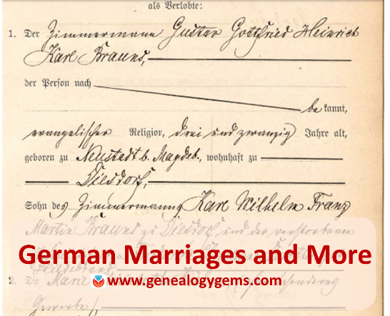
Germany Marriages: Magdeburg
Ancestry.com has published a new collection of over 600,000 marriages recorded in Magdeburg, a city about 80 miles west of Berlin. According to the collection description, “Beginning on October 1, 1874, local registry offices were made responsible for creating birth, marriage, and death records in the former Prussian provinces. The collected records are arranged chronologically and usually in bound yearbook form which are collectively referred to as ‘civil registers.’ For most of the communities included in the collection, corresponding alphabetical directories of names were also created.” The records date from 1874-1923.
1906 San Francisco Earthquake: The Ultimate Map
A new interactive map plots the likely locations of thousands of photos taken of the “smoke, fire, ruins and refugees” after the 1906 San Francisco earthquake. The map at OpenSFHistory references stunning images of bewildered survivors amidst their devastated neighborhood, reminders of the brutal and total losses many incurred in a few seconds.
Got a disaster story in your family history? Read these tips on researching it.
Was London the scene of your family’s disaster–specifically, the London Blitz? Click here to learn about an interactive map of the bombing of London during World War II.
Indexed Obituaries at Ancestry.com
Obituaries such as this one from the Western Christian Advocate (Cincinnati, June 28, 1844) often reveal unique personal and family information.
Ancestry.com recently updated several enormous national obituary indexes:
Thousands of obituaries or death notices are searchable in digitized newspaper collections, but indexes dramatically improve the odds of discovering them. Then the trick becomes tracking down the original paper to see it for yourself. Learn more about finding obituaries (and everything else in newspapers) in How to Find Your Family History in Newspapers by Lisa Louise Cooke.
South Africa Court Records
Over 200,00 records appear in Ancestry.com’s new database, South Africa, Miscellaneous Court Records Index, 1652-2004, 2008-2011. Spanning more than 350 years, the collection indexes records from the Courts of Justice (1652-1956), Cape Town Criminal Records (1854-1855), Official Name Changes (2008-2011), South African Law Reports (1828-2004), and the 1859 Weenan, Natal Jury List.
“The details provided for each person typically include name, record date, record place, collection, and source,” states the collection description. “Depending on the collection, additional details such as occupation, place of residence, names of relatives, or information on a court case or crime may be available as well.”
UN War Crimes Commissions Archive Opened
The Guardian recently reported that the UN War Crimes Commission archives is being opened in London and its catalog is now searchable online. “War crimes files revealing early evidence of Holocaust death camps…are among tens of thousands of files to be made public for the first time this week,” says the story. “The archive, along with the UNWCC, was closed in the late 1940s as West Germany was transformed into a pivotal ally at the start of the cold war and use of the records was effectively suppressed.” The archive contains thousands of pages of evidence collected (much of it in secret) even as the war raged, and includes detailed descriptions of Nazi extermination camps, massacres in Czechoslovakia, and early war crimes tribunals.
Newspapers in the News
North Carolina
Digitized issues of The Franklin Times (weekly, searchable 1909-1924) are now searchable at Digital NC. The paper served Lewisburg, the seat of Franklin County, North Carolina. The paper has a fairly local focus, according to a blog post announcing the collection. “For example, one weekly column, ‘The Moving People,’ tracks ‘those who have visited Louisburg the past week’ and ‘those who have gone elsewhere for business or pleasure.’ The column lists individuals who returned from trips and those who visited from afar….Local meetings, contests, municipal issues, social events, and more are recounted each week.”
Washington
Lisa Louise Cooke just found a little piece of her own history in Washington State University’s student newspaper, now fully searchable online for free. It’s a short snippet that refers to a two-woman play Lisa was in!
According to a Facebook announcement, a new digital archive includes 13,200+ issues of the The Daily Evergreen (1895-2016) and 660 pages of other newspapers, including an early official student paper, the College Record (1892-1893).
Find your own family history in newspapers of all kinds, from local dailies to labor presses or church regionals, or even student papers such as the one Lisa used above. “Read all about it!” in Lisa’s book, How to Find Your Family History in Newspapers.
Research WWII ancestors with these three tips. The experiences of our ancestors during World War II add a rich texture to their personal history. Whether in the military, on the home-front, or those living in neighborhoods that became battle zones, find their stories with these helpful tips.
In Everyone Brave is Forgiven by Chris Cleave, our current Genealogy Gems Book Club title, we read about different ways Londoners experienced World War II. A soldier shipped out to Malta, a female War Office recruit, a child evacuee, a civilian running regularly for underground shelters as bombs fell; these are just a few of the book’s poignant stories.
That diversity of experience was part of our ancestors’ lives, too. Some served in the military and some kept the home fires burning. Some even dodged bombs or bullets in their own neighborhoods! Many experienced the horrors of concentration, POW, or other types of interment camps.
As many different experiences as they had, there are just as many ways to research their lives during WWII. Here are several scattered examples of the kinds of records and resources you may find. Do a little of your own exploring to see whether the kinds of materials below exist for your WWII ancestors.
Research WWII Ancestors: On the Home Front and in Harm’s Way
Lisa’s grandmother heading off to work at Kaiser’s Richmond Shipyards, c. 1941
Millions of civilians’ lives were directly affected by the war. Many women entered jobs for the first time in their lives or began doing new types of volunteer work. Families faced rationing, price controls, and blackouts. Some unfortunates found themselves in the path of the war.
Speaking of maps, one resource your home-front family would have used to follow troop movements and the progress of the war were the Stanley Turner maps. His collection contained a unique series of action-packed maps. These can add a fascinating and colorful layer of understanding to your family’s experience during this time.
Must-reads: The Genealogy Gems Book Club
The Genealogy Gems Book Club is an exceptional virtual book club for everyone. Every quarter, we recommend a fiction or nonfiction title that has a compelling slant for family history lovers. Then, we interview the author and share the conversation with you. Right now, we’re talking about Everyone Brave is Forgiven by Chris Cleave, who joins us in a couple of weeks on the Genealogy Gems Premium Podcast (there’s an advance teaser in the free Genealogy Gems podcast episode 195.) Watch for these episodes and check out other titles we’ve recommended in The Genealogy Gems Book Club!
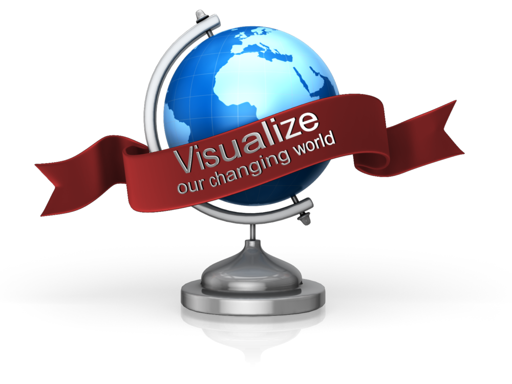
Time-lapse videos first intrigued me as a child when I watched a little seed grow into a beautiful flower in a matter of seconds. Now, illuminating time-lapse videos and tools are helping genealogists visualize our changing world.
Last month, animator Max Galka published a time-lapse map of the history of urbanization over nearly 6,000 years in just three minutes.
Mr. Galka mentions on his blog that tracking urbanization occuring before the mid-20th century was a difficult task – until recently. A team of Yale researchers published a collection of urban population data dating back to ancient times which helped Galka create his video. Their collection was quoted to be a “clean, accessible dataset of cities, their locations, and their populations over time.”
I was surprised how quickly things changed and found it amazing still how many places in the world are yet to be “urbanized.”
Time-lapse Video Covering Immigration to the U.S. Since 1820
Again, Max Galka presented an amazing animation of immigration to the United States. This creation shows the countries that sent the most people to the U.S. since 1820.
The U.S. is a nation of immigrants, says Galka. As each dot flies across the page, it represents 10,000 people who immigrated to the U.S. In the bottom left corner, Mr. Galka lists the three top countries where immigrants are coming from at any given time. I was stunned as the map lit up in Russia and Africa only fairly recently. It is clearly shown that the U.S. is indeed a nation of immigrants in this colorful time-lapse video.
Time-lapse Tools for Genealogy
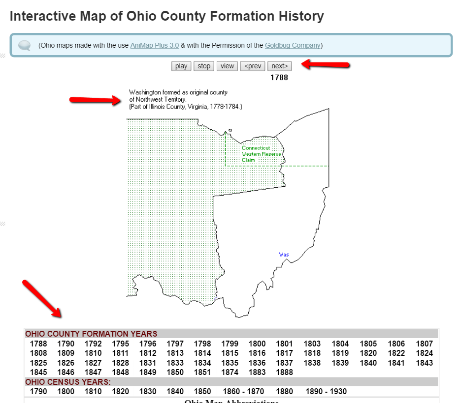
As a genealogist, I am constantly in search of county records. So many times, county lines or boundaries changed. I even have one family that lived on the same farm, but technically resided in three different counties over a period of about 50 years. We can’t possibly know when each county of any given state was formed or created, until now that is.
One of my favorite tools for discovering county changes over time is the Map of US.org website. You can find a map of each of the 50 states and run the interactive formation sequence. For example, I can find the Ohio map.
The Ohio map begins in 1788. It indicates the one county in the Northwest Territory (today’s Ohio) at that time. Washington County was formed as the original county of the Northwest Territory and was created from part of Illinois County, Virginia. That’s another reason I love these interactive maps. With the creation of each county, the map indicates from which parent county or counties it was formed. This is a great help for genealogy research. When I can’t find my targeted ancestor in the county I thought they should be in, I can determine when the county was formed and from what parent county or counties it was formed from. Then, I can quickly determine the other locations that may have records I need.
In addition to the interactive time-lapse maps, each state has a list of other helpful maps that may be of interest to you. For example, the map links for Oregon include the Historical Maps of Oregon, a set of beautiful old maps that can be viewed or downloaded.
Maps can give us a bigger picture of our county, our state, our country, and even the world. These tools help us picture our ever-changing world. What impacted you the most while watching these videos? We would love to hear from you in the comments below!
If you feel inspired to learn more about map visualization, you will enjoy Lisa’s Google Earth video. Lisa was an early pioneer of genealogical data visualization and has been teaching genealogists how to use the free software for the last several years. You can watch the free Google Earth for Genealogy video here or check out her revised and updated e-book, The Genealogist’s Google Toolbox 2nd Editionto learn even more tips and tricks for Google genealogy research.
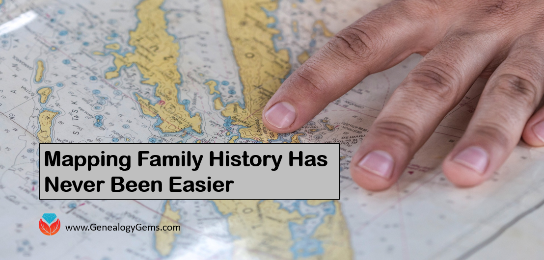
Family maps and migration routes can sometimes uncover new record finds and answer brick wall questions. It’s fast and simple to use these free tech tools to map your family’s history! I used them to track my ancestors as they trekked from the eastern seaboard to the Midwestern United States and found some fantastic leads!
There are two online treasures I have just discovered. FamilySearch and MyHeritage family trees can now be mapped with some neat interactive tools. MyHeritage just launched their PedigreeMap saying it is an “innovative way to view your family history,” and I think they are right. I have used migration maps to help me overcome brick walls and questions in my research for years. Using these free online tools have made it really fun and not difficult at all.
Creating Family Maps and Migration Routes at MyHeritage
PedigreeMap is free for all MyHeritage users. To access it, log on or create a MyHeritage account. If you are new to MyHeritage, you will be prompted to begin creating your free family tree when you click Sign up at the top right corner of their homepage.
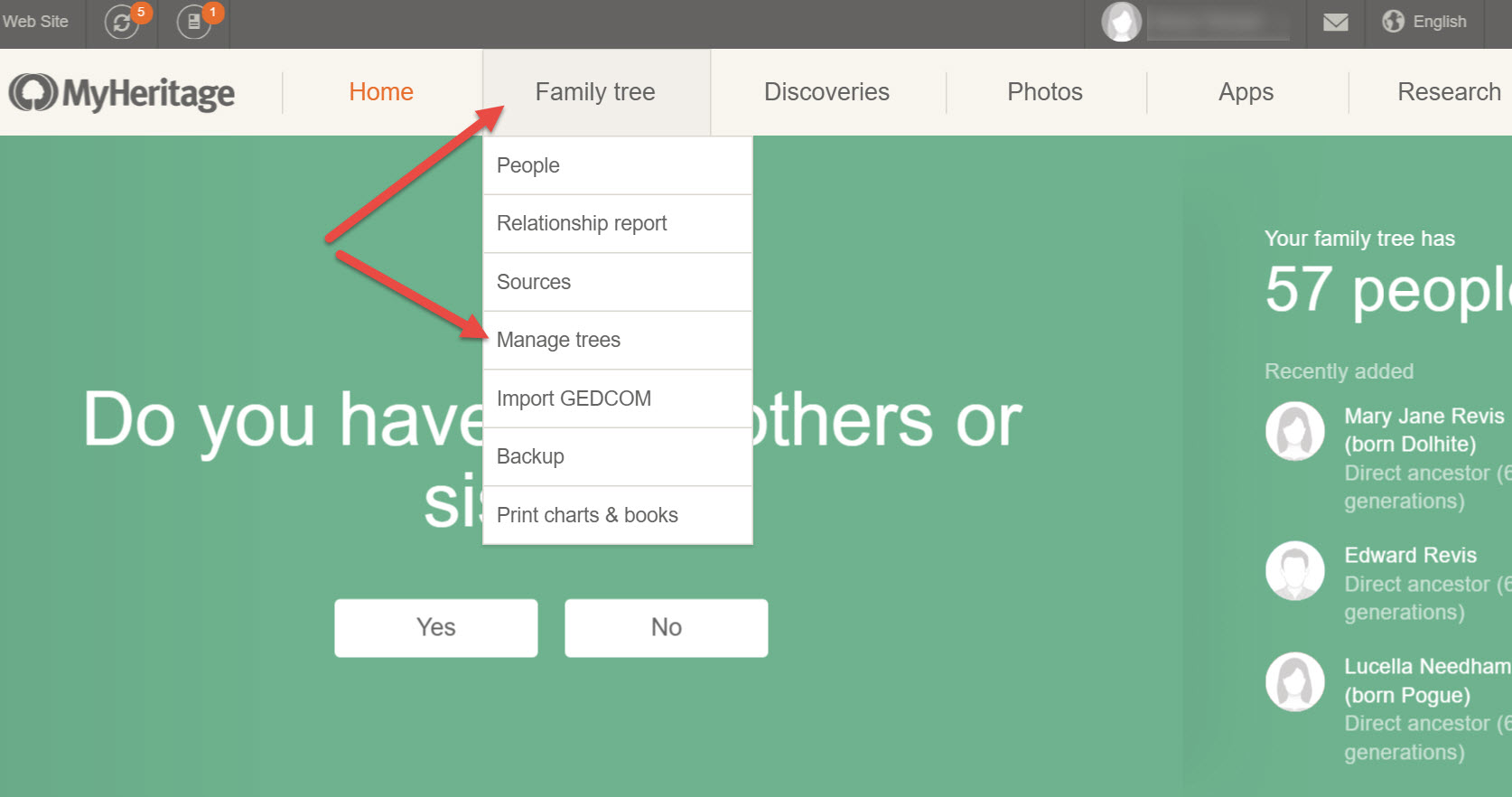
Once you have created your family tree, find it by clicking Family Tree and choosing Manage trees from the pull-down menu.
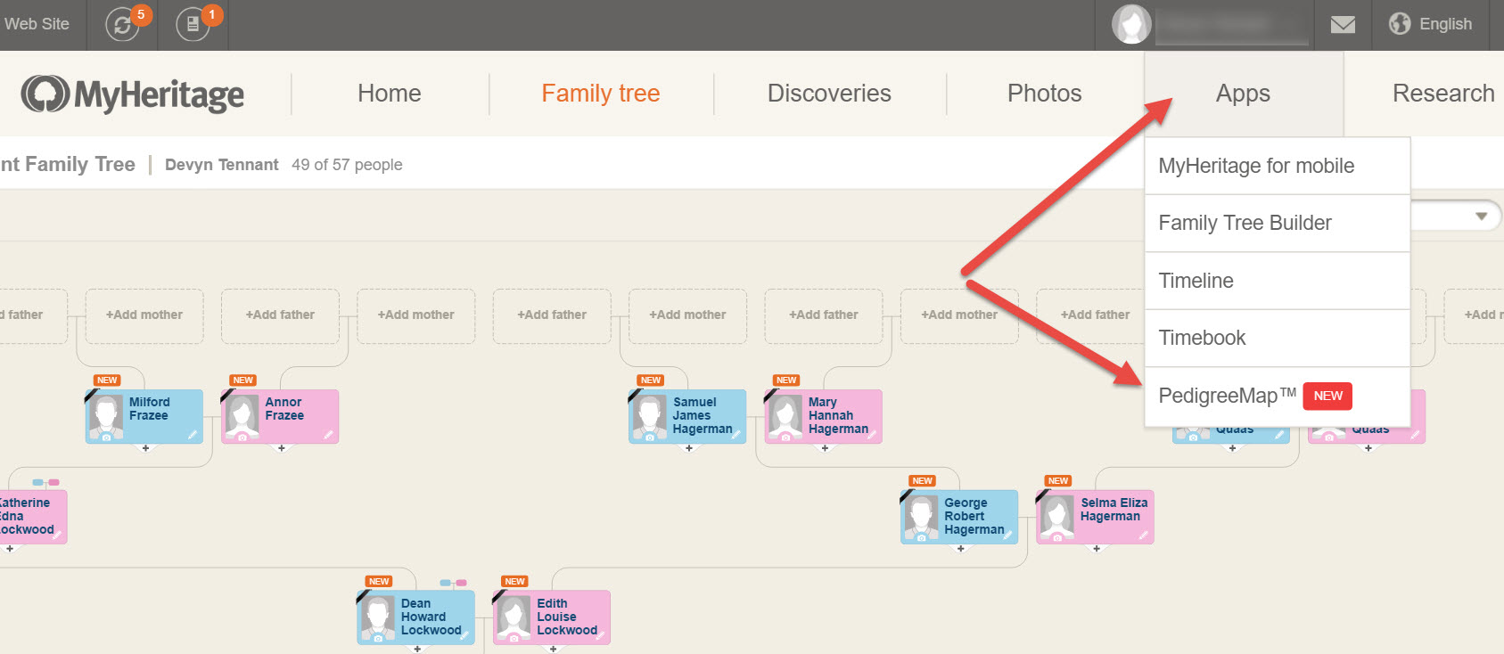
To use the PedigreeMap feature, choose your family tree from the list and then click on Apps and choose PedigreeMap from the pull-down menu.
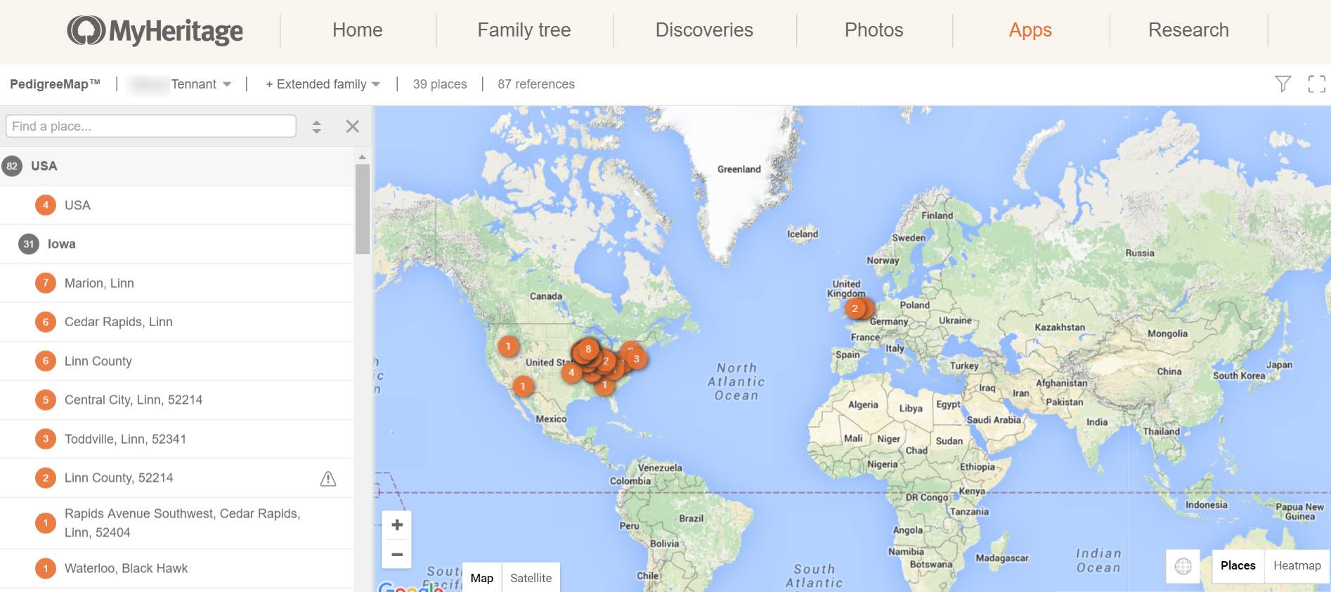
You will be able to see a map of the entire world in which your ancestors lives are plotted. From my map below, I can see the large concentration in the eastern half of the United States, but also the location of my ancestors from Europe.
Not only are genealogical events like births, marriages, and deaths plotted on your map, but if you put in a location of a picture, it will plot that too. You will notice, on the left-hand side there is a list of all the places that appear in your family tree. The numbers on the list match up to the number of each place in your family tree.
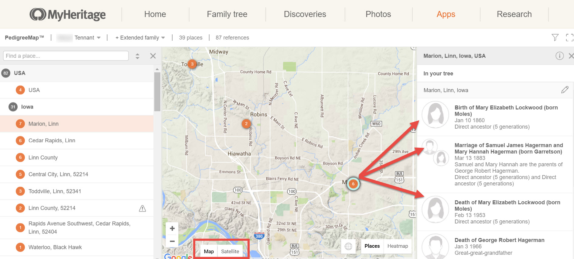
You can zoom in or zoom out, but my favorite part is clicking a location in the list to the left. For example, if I click on Marion, Linn, another list pops up on the right. This list shows me what events took place in Marion, Linn County, Iowa.
Additionally, I can see major roads, rivers, and hills. I can even click on the satellite view to see the street where my great-grandparents were married!
There are many more wonderful tools on PedigreeMap that you will want to check out. To learn more about all the unique features, read their article here.
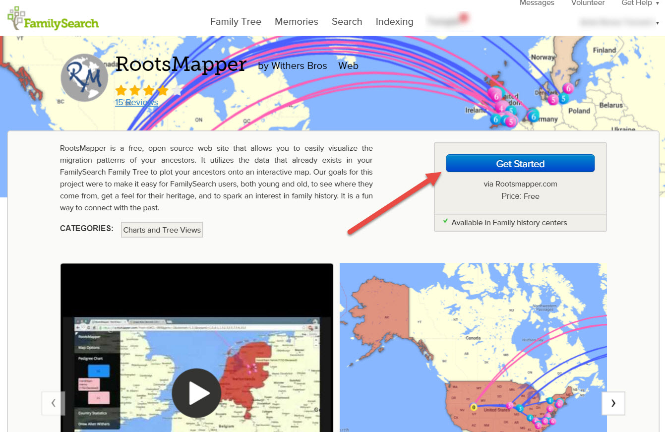
Creating Family Maps and Migration Routes with FamilySearch
RootsMapper has been around awhile and is an interactive mapping website that works with FamilySearch. As you know, FamilySearch allows users to create a family tree online and search all their records for free. Like PedigreeMap, you will need to create your free account and family tree at FamilySearch. Then, go to the FamilySearch Apps page and click on RootsMapper. Now, click Get Started.
When you are redirected to the RootsMapper homepage, click Login to begin mapping. You will use your FamilySearch username and password. By clicking Accept, you give permission for RootsMapper to use your FamilySearch tree data.
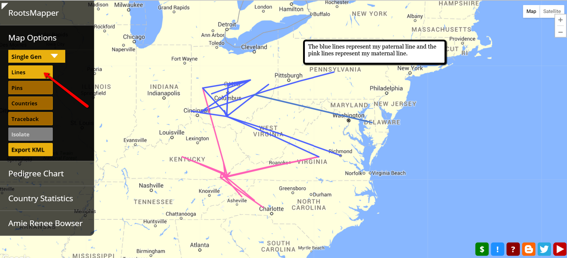
The interactive map has various features. I particularly like the lines showing both the migration of my paternal line and my maternal line.
Did you notice my paternal line goes right through modern day West Virginia? Several years ago, I had “lost” my Walls family line. By plotting their known whereabouts on a map and connecting the dots, I could see possible migration routes. In fact, during that time frame, they likely took nothing but trails into Monongalia, Virginia. I did a search for records along this path and was surprised to find my fifth great grandfather on a tax roll for Virginia in 1790!
You can play around with the settings and map just one generation, five generations, or even ten generations. The options allow for pins, migration lines, changing the root person you are charting and much, much more.
It really is amazing how innovative genealogy research is today. The Genealogy Gems team delights in sharing new tech tools and tips to help you in your genealogy goals. Why not try out one of these family map and migration route tools today and share with us your thoughts? Leave a comment below!
An interactive map lets you explore The Blitz: the intensive Bombing of London by the Germans in 1940-1941.
View from St. Paul’s cathedral after the Blitz. Wikimedia Commons image; click to view.
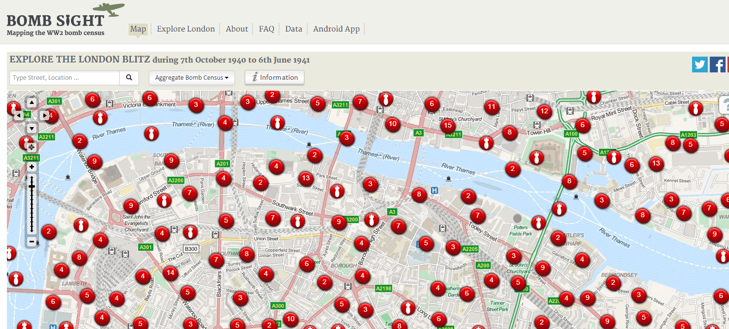
We see the images often in WWII-era movies. Londoners hunched in tube station tunnels during air raids. Children evacuating the city by the thousand. The Blitz was a period of intensive bombing of London by the Germans that began in September 1940 and continued through the following June. Now we can explore exactly where and when all those bombs fell at a new interactive website, Bomb Sight.
“With Bomb Sight you can discover what it was like in London, during WW2 Luftwaffe Blitz bombing raids, exploring maps, images and memories,” explains the site. “The Bomb Sight web map and mobile app reveal WW2 bomb census maps between 7/10/1940 and 06/06/1941, previously available only by viewing them in the Reading Room of The National Archives.”
As you can see from this screenshot, the site is map-based. All those red dots you see are bombings. (Can you imagine bombs falling that thickly in your own neighborhood?) Different icons reveal the type of bomb. Click on them to learn more about that event. You can even view historical images of that neighborhood and read stories and memories relating to that area. You can ask to map to show you only the first night of the blitz, a weekly look or an aggregate (all-inclusive) view, like the one shown here.
Though you can search visually, you can also enter a street or postcode to look at a specific area. Zoom in or out; explore different map layers for different types of information.
These maps were created from 559 map sheet originals that were declassified in 1971 but are very fragile today. So this site represents a fantastic new free resource that hasn’t been widely accessible to the public. It’s stunning to look closely at a neighborhood and see how densely the bombs fell. It’s also stunning to pan out to the widest view and see SO many dots. So many bombs. So much destruction.
Immerse Yourself in The Blitz: Everyone Brave is Forgiven
Everyone Brave is Forgiven by British novelist Chris Cleave is a story about love and war during some of the longest sustained bombing campaigns of World War II. It immerses readers in the harrowing experiences of The Blitz, as civilians frantically piled their children onto trains headed for rural parts unknown, then spent the next several months running for underground shelters whenever the bombs came. You’ll read about children who gradually snuck back into the city, only to find themselves homeless and orphaned. You’ll careen along with female ambulance drivers who dodged explosions and ruins during air raids as they raced toward smoking ruins. But amidst all this devastation are stories of love, romantic and otherwise, and stories of bravery, amidst moments of fear and panic. This Genealogy Gems Book Club pick was an instant New York Times best-seller, and for good reason! Click here to pick up your e-book or print copy.
About Genealogy Gems Premium Website Membership
The video class you just caught a peek of is one of the perks of Genealogy Gems Premium membership. For one low annual fee, members can watch more than 2 dozen Premium member-only videos on genealogy research strategies, organization, technology tools (like Google, Google Earth, Evernote, Dropbox and cloud computing) and more. And we keep adding new videos regularly! Premium website members also have access to our monthly Premium podcast and all archived episodes. Click here to learn more!
Thanks for sharing this post with others who will want to learn more about the bombing of London during World War II. Just email the URL or post this article on your favorite social media channel.
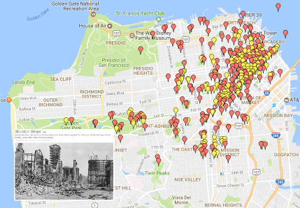 1906 San Francisco Earthquake: The Ultimate Map
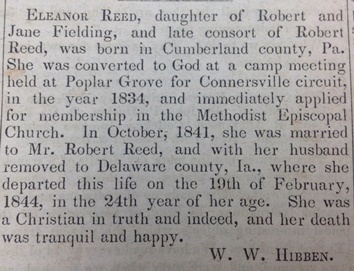
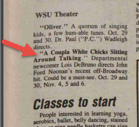 Lisa Louise Cooke just found a little piece of her own history in Washington State University’s student newspaper, now fully searchable online for free. It’s a short snippet that refers to a two-woman play Lisa was in!


 Family maps and migration routes can sometimes uncover new record finds and answer brick wall questions. It’s fast and simple to use these free tech tools to map your family’s history! I used them to track my ancestors as they trekked from the eastern seaboard to the Midwestern United States and found some fantastic leads!