by Lisa Cooke | Aug 8, 2014 | 01 What's New, Digital Archives, Google, Maps
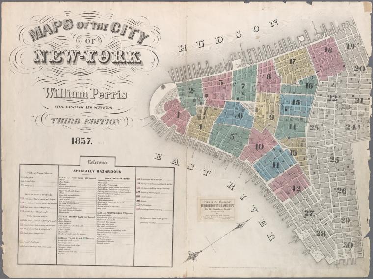
Map of New York City, 1857. Click for full citation information.
Thousands of historical maps of New York City, the mid-Atlantic states and even the Austro-Hungarian empire (yes, really!) are now online–and they’re free.
The New York Public Library has published more than 20,000 historical maps dating from 1660-1922. They are free for public use, downloading, manipulating and publishing! A lot of the maps are from New York City neighborhoods, like the one shown here.
The author of a news item about the collection said this: “We can’t imagine too many people wanting to remix Gangs of New York-era property charts, but it’s hard to object to getting more geographic knowledge at no charge.” Well, we genealogists may not “remix” these old property maps, but we can certainly see the value in them!
Do you use maps in your research? Have you tried overlaying a historical map showing an ancestor’s home with a modern one on Google Earth? Learn more about using Google Earth in your genealogy research in this FREE video.
And if this post is interesting to you, you should also read this blog post about interactive historical maps of major cities (like New York City).
by Lisa Cooke | Jan 13, 2014 | 01 What's New, Google, Maps
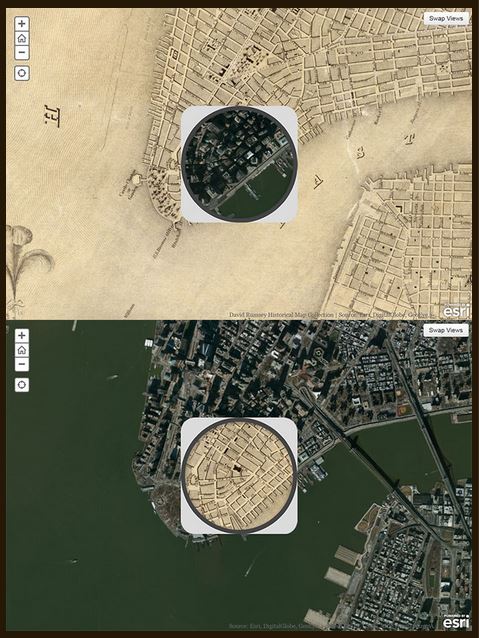
1836 map of New York City compared to modern satellite image, shown with each map in “spyglass” format. Image from David Rumsey Map Collection blog at DavidRumsey.com.
I love showing people how to use online tools to compare historical maps to modern ones. You can map out your ancestor’s address, check out their neighborhoods “then and now,” map their route to work, see if their old home still exists and more.
Well, the online Smithsonian magazine has created an exciting new interface for six American cities. Now you can compare modern satellite imagery with bird’s-eye views of:
You’ll see great city layouts before the fire that claimed much of old Chicago, the San Francisco earthquake, the Lincoln memorial and more. The historical map of New York City is the oldest, but the other maps capture each city at a critical point in their growth. For each city you can look at a historical map with a “spyglass” mouse-over of a modern satellite image, or vice-versa, as shown in the New York City map on the right. Each map is accompanied by a fantastic Smithsonian article; the historical maps come from the amazing David Rumsey Map Collection.
As many of you know, it’s possible to do something similar (or even better) with Google’s amazing mapping tools. Learn how to do that with these three Genealogy Gems resources:
1. My FREE Google Earth Video, which teaches you how to unlock mysteries in your research, from unidentified photographs to pinpointing homesteads;
2. My Google Earth 2-Disk Bundle, with detailed demonstrations and examples so you can SEE for yourself how to use Google’s mapping tools;
3. My new Time Travel with Google Earth video, in which you’ll see old maps, genealogical records, images, and videos come together to create stunning time travel experiences in Google Earth. This is available to Genealogy Gems Premium Members (learn more membership here).
by Lisa Cooke | Oct 20, 2013 | 01 What's New, History, Maps
A recent blog post at slate.com caught my eye because it features a map from the genealogists-love-it David Rumsey map collection. But what captured my attention was the story the unfolded behind the foldable map itself. I think you’ll love it!
Blogger Rebecca Onion uses a 1929 souvenir map of the United States to tell the story of early commercial air traffic–specifically the story of the origins

Rumsey TAT map
of airline giant TWA. Apparently early “transcontinental flights,” as they were advertised, were sight-seeing tours with short flights interspersed by train rides to the next flight location. The map featured in her blog post was a souvenir of one of these passengers, who added his own colorful comments on his experience.
This fun post is part aviation history, part map-lover trivia. The story unfolds even more in a short video documentary on Transcontinental Air Transport I’ve added below. It includes cool aerial shots and more on how the early air transport industry, er, got off the ground.
And don’t forget to use maps (storied or just the plain informational types) in your family history research! These can help you find your way around ancestral hometowns, chart migration routes as they would have and otherwise see the world (literally) in the same ways they did. David Rumsey’s map collection is one of the best online collections out there, with free access to over 44,000 high-resolution historical maps.
Learn more about how to use the David Rumsey historic map collection in conjunction with Google Earth by watching my free video class Google Earth for Genealogy.
My Genealogist’s Google Toolbox Kit, is a value bundle that includes my book The Genealogist’s Google Toolbox and Volumes I and II of Google Earth for Genealogy (on video CD). And right now the kit is available for 20% off!
by Lisa Cooke | Jul 21, 2013 | 01 What's New, British, Maps
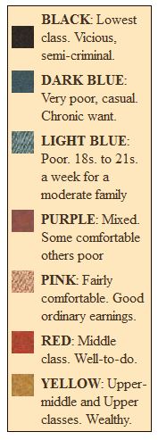
Booth Poverty Maps key
There is a fantastic blog posting on Mad About Genealogy about the Booth Poverty Maps, which look like a riveting way to understand your ancestor’s 1880s London neighborhood.
According to blogger Linda Elliott, “Booth employed a team of social investigators who walked around the London streets often in the company of the local policeman and recorded what they saw and heard. The notebooks that they filled out can be viewed online and make for fascinating reading with amongst other findings they record what the policeman thought of each street and sometime each building and its inhabitants.”
I’ve shown the map key here (right), clipped from The Charles Booth Online Archive. Linda describes each category in greater detail in her blog post, along with everything a genealogist needs to know to use the maps.
by Lisa Cooke | May 8, 2013 | 01 What's New, Maps
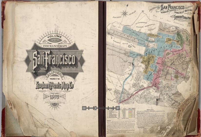
Opening pages of rare 1905 Sanborn Map of San Francisco, showing city just before 1906 earthquake. Find the entire map book at the David Rumsey Historical Map Collection
Genealogists rely on historical maps to help us navigate the geography of our ancestors’ lives. One of the most important resources available online is the David Rumsey Map Collection. Well, Rumsey recently announced on his website that he will be making more than 38,000 of his historical maps–everything he’s currently got online–available at the Digital Public Library of America (DPLA).
I blogged recently about the DPLA, which aims to create an enormous, free digital library we can all access online. It will be great to have the Rumsey map collection searchable on the DPLA so we can search these maps while we look for any other sources on any particular location our ancestors lived. “Maps tell stories that complement texts, images, and other resources found in the growing DPLA library,” says Rumsey. “And the open content policies of my online library fit perfectly with DPLA’s mission to make cultural resources freely available to all.” He applauds what the DPLA is trying to accomplish and even encourages other collectors to donate content.
Rumsey has spent years collecting thousands of old maps and putting them online. Now he’s working to share them even more widely. His entire collection of about 150,000 maps will eventually be housed at Stanford University. Meanwhile, we can all enjoy the thousands of images we can search on his site or at the DPLA.
Google’s free program Google Earth includes nearly 150 historic maps in the Layers panel. You can also add historic maps downloaded from Rumsey’s site to Google Earth by using the Overlay feature. My video tutorial series called Google Earth for Genealogy will show you how. You can also get step-by-step instructions in my book The Genealogist’s Google Toolbox. Or get them all in a discounted bundle.