5 Expert Tips for Using Meyers Gazetteer for Your German Genealogy

Track down your German ancestors with Germany genealogy expert Jim Beidler. He’s here to share great tips for using MeyersGaz.org, the recent online collection of crucial historical German maps.

meyersgaz.org Meyers Gazatteer

The Meyers Gazetteer is a comprehensive, indexed map to every place name in the Second German Empire (1871-1918). It’s based on the 1912 book commonly known as “Meyers Orts” or the Meyers Gazetteer: Meyers Orts- und Verkehrs-Lexikon des Deutschen Reichs. Recently, a free version of the Meyers Gazetteer became available online at www.MeyersGaz.org.

5 Tips for Using the Meyers Gazetteer

German research expert Jim Beidler, author of Trace Your German Roots Online, recently offered Genealogy Gems followers five tips for using the site to trace your German roots:

1. Correctly locating the village of origin is often the key to finding Germany’s many locally-based records. The FamilySearch catalog, shown here, places German villages in the same political jurisdictions as Meyers-Ort (Second Empire), which can be incredibly helpful when looking for microfilmed church and other records. (Click here to learn more using the FamilySearch catalog and the end of their microfilm lending program.)

2. When searching the Meyers Gazetteer online, don’t use diacritical marks such as the umlaut (the two dots) or expand umlauted vowels (such as by turning an ä into an ae).

3. Filter search results to a specific German region to narrow results.

4. Explore places with an interactive map that allows you to zoom in and out and toggle back and forth between the past and present. After clicking on a search result, click Map. An interactive map will appear. Roll over Toggle Historical Map to see options to resize and to select whether the map shows you local jurisdictions, surrounding German civil registration offices (StdAs), and Catholic, Protestant and Jewish places of worship.

5.  Click on Ecclesiastical to learn more about church parishes within 20 miles, which may have kept records on your family.

More from Jim Beidler on the Meyers Gazetteer

Genealogy Gems Premium members can sign in to our website and hear Jim go more in-depth on the Meyers Gazetteer for German genealogy research in Genealogy Gems Premium Podcast episode 143. Jim applies his decades of German research experience to the latest technological advances and brings you along for the ride!

Jim Beidler is the author of Trace Your German Roots Online, one of Family Tree Books’ top-selling genealogy guides.

How to Use Sanborn Fire Insurance Maps for Family History

Sanborn fire insurance maps help genealogists map out their ancestors’ neighborhoods and everyday lives. Nearly 25,000 digitized Sanborn Fire Insurance Maps are now on the Library of Congress website–and more are coming. Here’s what they are and how to use them for family history.

sanborn fire insurance maps

What are Sanborn fire insurance maps?

Sanborn fire insurance maps are a gem of a resource for those researching their roots in the U.S. (and parts of Canada and Mexico). These were detailed maps of city neighborhoods published periodically by the Sanborn Map Company beginning in 1867. They became available for a large number of cities by the 1880s and for many, were updated periodically for many decades. Today, the entire Sanborn fire insurance map publication series covers over 12,000 cities and includes over 700,000 maps.

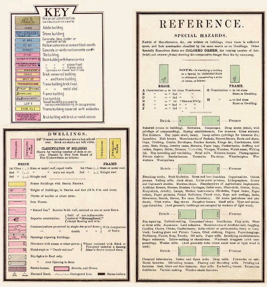
Sanborn maps are valuable for “anyone with a personal connection to a community, street, or building,” explains a recent article from the Library of Congress. “They show the size, shape, and construction materials of dwellings, commercial buildings, factories, and other structures. They indicate both the names and width of streets, and show property boundaries and how individual buildings were used. House and block numbers are identified. They also show the location of water mains, fire alarm boxes, and fire hydrants.”

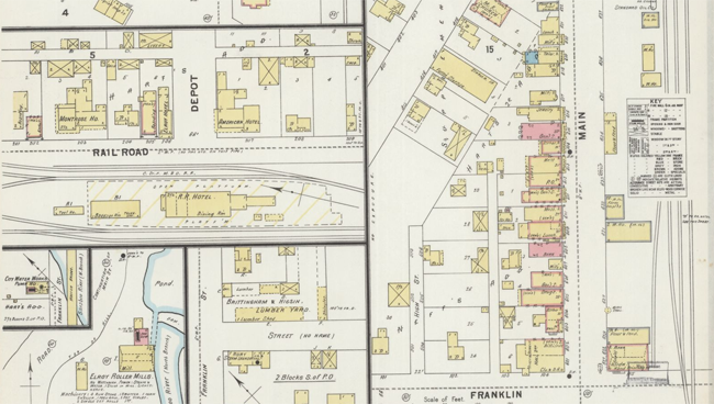
Here’s a sample map clipping from Elroy, Wisconsin:

sanborn fire insurance maps elroy WI


How to use Sanborn fire insurance maps for your family history

The information in Sanborn fire insurance maps served the needs of urban planners, developers, and insurers, and now it can serve your genealogy research, too. A series of Sanborn maps is almost like stop-action aerial photography of your ancestor’s home and surroundings, with clues that can lead you to new documents and insights about their lives. Here’s a summary of how to use them:

1. Learn where exactly your ancestor lived. Look for a street name and house number in documents relating to your ancestors, such as city directories, deeds, WWI or WWII draft registrations, or passport applications. U.S. censuses have columns for house numbers and street names beginning in 1880, but are more likely to be filled in starting in 1900.

2. Find maps for that city. (See below for top places to find them online.) Find volumes published before, during, and even after your ancestors lived there.

3. Locate the map sheet with your family’s neighborhood using the map index in the front pages of the map volume. (Look for a street index.) Go to the correct map sheet.

4. Find the address. Look closely at the individual lot that belonged to your family, if you can identify it from the house or lot number (deeds may have lot numbers on them). You’ll likely be able to see the property boundary lines with measurements, along with the dimensions and footprint of buildings on the lot. Some details, such as as the building use, construction or whether it had asbestos or fire escapes, may be explained in Sanborn’s colorful map keys, like the one shown here from the Library of Congress website.

5. Check out the neighborhood. What kinds of buildings or features surrounded your family’s home? What schools, churches, factories, and other local institutions may have served your ancestors, and how far away were they? If you know where a relative worked, do you see the workplace nearby?

6. Compare maps from year to year. During the time your family lived there, the neighborhood likely evolved. There may have been new housing, business, road layouts, street names and numbering, and property use. You may see over time that an outbuilding was built, then transformed from a stable to a garage.

7. Use these details to create a description of your family’s everyday surroundings. Did they live in a brownstone duplex, frame home, or tall apartment building? Did their five-story walk-up have fire escapes? How close was their home to their neighbors’ home? How large was the lot, and what kinds of outbuildings were there? What kinds of buildings or features surrounded the property? How far away were the amenities they needed for daily life?

8. Note additional records to check. Do you see a nearby church, school, funeral home, cemetery or another institution that may have created records about your family? Follow up by looking for their records. (Click here to read my favorite online search strategies for finding records.)

Where to find Sanborn fire insurance maps online

Now we come to some excellent news. The Library of Congress now has over 25,000 digitized Sanborn fire insurance map sheets online! The collection description says these sheets come “from over 3,000 city sets online in the following states: AK, AL, AZ, CA, CO, CT, DC, DE, GA, ID, IL, IN, KY, LA, MA, MD, ME, MI, MO, MS, NC, ND, NE, NH, NJ, NV, OH, OK, PA, SD, TX, VA, VT, WY and Canada, Mexico, Cuba sugar warehouses, and U.S. whiskey warehouses.”

That’s fantastic, and the Library of Congress says more are coming. Recently they announced that over the next three years,  they will be adding new map sheets every month until all 50 states are covered from the 1880s through the 1960s! By the end of the project, half a million Sanborn fire insurance map sheets will be online. So it will be worth checking back periodically to see if the maps you want are there.

Other digitized collections of Sanborn maps are online, too, and published collections exist at major libraries. Use the search strategies mentioned in this article to find them.
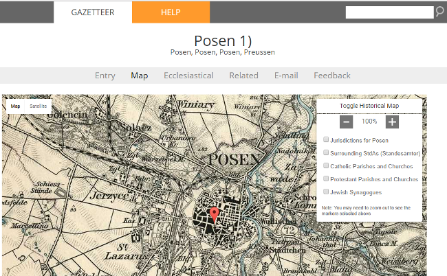
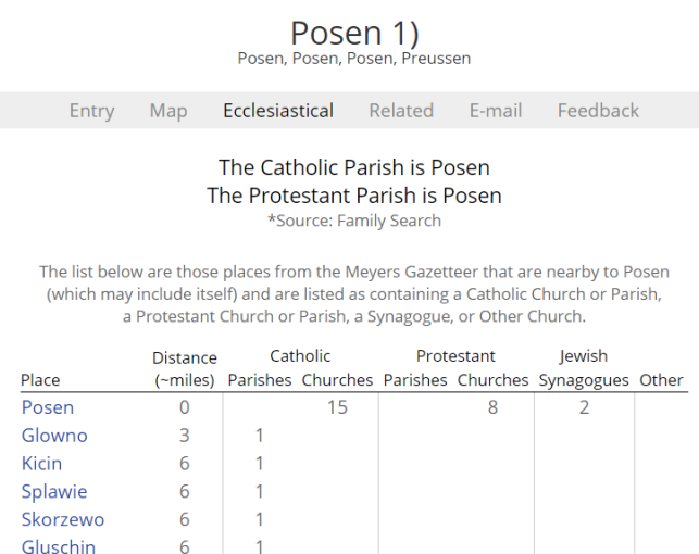
genealogy video premium buttonDid you learn something in this article? You can learn even more by becoming a Genealogy Gems Premium website member. Members of my site get access to more than 35 exclusive genealogy video tutorials. I have an entire video class just on using Sanborn maps! You’ll get to explore what these maps look like and how to use them. Click here to see a current list of Genealogy Gems Premium website videos: which ones would help your research most right now?

4 Steps for Using Google Earth for Genealogy

Use Google Earth for genealogy to find long-lost family locations on modern maps. Here’s how!family history google earth tour

It can be very surprising to discover that you lived somewhere that you never knew you lived. That was the case for Professional genealogist Alvie Davidson, who recently wrote to me. He’d done some fantastic sleuthing on his own recent family history, and discovered that his family had lived in Huntsville, Alabama when he was a toddler. “This is the first I have even known they lived in Madison County, AL.” But he was not sure about how to use Google Earth to help him locate the family addresses he’d discovered.

“I have learned from the U S Government that my parents lived at (three) different addresses in Huntsville, Madison County, AL when I was a toddler in 1944….I never knew we lived in Huntsville but I learned my mother worked for munitions productions during World War II at Redstone Arsenal. She worked several months toward the end of 1944 and had to quit due to onset of pregnancy. We moved to Florida shortly after she left employment at Redstone Arsenal because we show up on the 1945 Florida State Census.”

Alvie sent me three family addresses. Then he asked for some step-by-step help instructions on how to put Google Earth to work to identify their location today.

4 Steps to Revealing More with Google Earth

1. Search each address in Google Earth. Enter the address in the search box in the upper left corner of Google Earth. If you get a hit, mark it with a placemark (clicking the button that looks like a push pin in Google Earth’s toolbar) and name it. In this case I found two of the three street addresses.

2. Locate a map of the area for the appropriate time period. With a little Google searching, I found the 1940 census enumeration map for Huntsville at the National Archives website. Here’s what that map looks like. (Image right) I then went in search of each of the three addresses on the map.

In this case, I conducted a block-by-block search of the 1940 enumeration district map for the missing address: 110 Winston Street. Unfortunately, not all the street names were clearly legible on this particular map, and I was unable to locate it.

You can learn more about locating enumeration district maps in my article How to Find Enumeration District Maps.

Genealogy Gems Premium Members: log in and watch my Premium video 5 Ways to Enhance Your Genealogy Research with Old Maps featuring instruction for locating and using enumeration district maps.

3. Overlay and georeference the enumeration district map in Google Earth to compare the past to the present. Georeference just means to match up known landmarks on the historic map with physical locations on the modern-day map, thereby allowing you to match the two maps up together. By so doing, I was able to locate on the enumeration district map the modern-day locations of the two addresses that I found using Google Earth.

georeference historic map overlay in Google Earth

There are businesses in both locations today. Below right is a screen shot showing the current location of one of those addresses. Clearly no longer the old family home.Alvie Google Earth for genealogy problem

4. Dig deeper for addresses that have changed. As I mentioned previously, I searched for the 110 Winston Street address in Google Earth with no result. If that happens to you, remove the house number and run a second search on the street name alone. Numbers can change, but it is important to verify whether the street still exists today.

In this case, Google Earth did not locate a Winston Street in Huntsville, AL. Knowing that errors and typos can happen to the best of us, I ran a quick Google search for Huntsville, AL city directories, and verified that indeed Winston Street did exist at that time in history. So, at some point between 1940 and today, the name appears to have been changed.

I headed back to Google and ran the following search query:

“winston street” “huntsville alabama”

The quotation marks tell Google that each exact phrase must appear in all search results. The phrases will appear in bold in the snippet descriptions of each result.

google search

The result above caught my eye because it mentions the “Winston Street Branch Library.” Even when street names change, buildings named for those streets often don’t. However, in this case, the website discusses the history of the library, and the Winston Street Elementary School.  According to the website, the library “became a part of the Huntsville Public Library (now Huntsville-Madison County Public Library) in 1943. In 1947, the branch was renamed the Dulcina DeBerry Library.” Perhaps the street was renamed at that time as well.

Genealogy Gems Premium Members: Sign in and watch the Ultimate Google Search Strategies video class to learn more.

Jumping back into Google Earth I entered “Winston Street Branch Library” in the search box, and was immediately taken to the location, which is just south of the other two known addresses! At this point I would recommend to Alvie, who is a Genealogy Gems Premium Member, to watch my video class Best Websites for Finding Historical Maps to track down additional maps from the time frame that may have Winston Street clearly marked on the map.

Once I identified this landmark, I then marked the location with a placemark. You can turn off the 1940 enumeration district map overlay by unchecking the box next to it in the Places Panel. Doing this revealed the location on the modern day map. Finally, I headed to the Layers panel and clicked the box next to the “Roads” overlay to reveal the modern day street names.

street names

You can use this technique when you have more success than I did in finding an old address on an old map. Overlay the map, position a placemark on the location, and then turn the overlay off. With one click of the Roads layer you can now see the current street name for the old location you found on the map overlay.

Further digging online did deliver additional maps from the era and area:

google earth for genealogy


We all have locations in our family history that have given way over time to new buildings and parking lots. By using the power of Google Earth, Google search, and historic maps, they don’t have to be lost forever.

Get Started with Google Earth for Genealogy

Learn all these Google skills–with step-by-step tutorials and video demonstrations–in Lisa’s book and Google Earth video tutorial. Click here for a special price on the bundle!

FREE video: Get Started with Google Earth for Genealogy

Google Bundle! The Genealogist’s Google Toolbox Second Edition PLUS  learn how to create your own historical map overlays in my Google Earth for Genealogy 2-video CD set.

Use Google Earth to Plot Your DNA Matches


New Pictorial Maps on David Rumsey Map Collection

Map of Hollywood, 1928. Online at David Rumsey Historical Map Collection. Click on the map for full citation information.

Map of Hollywood, 1928. Online at David Rumsey Historical Map Collection. Click on the map for full citation information.

Pictorial maps are both fun and useful for finding our family history. These use illustrations in addition to regular cartographic images to communicate their messages.

For example, this 1928 map of Hollywood, California, inserts faces of the famous and illustrations of local attractions. But maps like those don’t just exist for popular tourist destinations. And now there are even more pictorial maps online and FREE to use at the David Rumsey Map Collection.

According to a press release, “Over 2,000 pictorial maps and related images have been added…in the form of separate maps, pocket maps, case maps, atlases, manuscript maps, and wall maps.”  These include “certain panoramic and birds-eye maps, diagrammatic maps, and timelines.” Pictorial maps were especially popular during the 1920s-1940s, but David Rumsey includes many from the 19th century and before. The collection continues to grow; check back often to look for the maps you want most.

Genealogy Gems Premium Membership and PodcastDid you know that I teach an entire video class on using historical maps in genealogy research? I’ve put a free excerpt on the Genealogy Gems YouTube Channel: Using Sanborn Fire Maps for Genealogy and Family History. Watch it below! Genealogy Gems Premium members can watch the full class, which goes in-depth on four MORE types of helpful historical maps, and download the companion handout! (Click here to learn more about Premium membership.)

Pin It on Pinterest

MENU