by Diahan Southard | Jan 17, 2015 | 01 What's New, DNA
(Update 2020) When genealogists take an ancestry DNA test, they are looking for more than just their ethnicity results. They are also very interested in receiving information on other people who have tested who closely genetically match them. They want to know who the closest matches are, and if those matches have family tree information that they can share.
However, with all the people testing these days, (some being genealogists and some not) the volume of matches can become overwhelming very quickly.
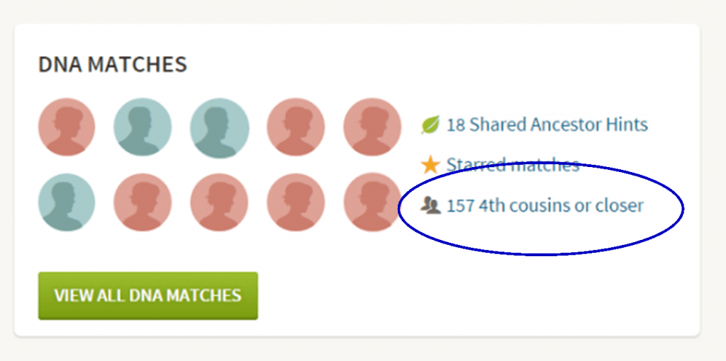
Are you one of those people who have way too many genetic “4th cousins or closer” among your DNA matches? Have you ever wondered “What do I do with all these matches?!” If so, keep reading. We’re going to explore some of your options, and most importantly, how to determine how genetically close your cousins really are.
Doing the DNA Math on Your Cousins
Math can provide us with a degree of certainty in genetic genealogy. Each of us has two biological parents. We have four biological grandparents, and eight great-grandparents.
However, the farther back we go the less we can rely on math.
For example, on paper you should have sixty-four 3rd great grandparents. However, many of us find that the same person occupies more than one slot on our pedigree chart. While this significantly decreases the workload for traditional genealogy, it adversely impacts your genetic genealogy. Especially when it comes to that long long list of 4th cousins you have in your match list at any of the three major DNA testing companies.
Depending on how intermarried your lines are, you may be seeing individuals on your match list that genetically look like your fourth cousins, but they are genealogically your sixth cousins – EIGHT TIMES! So how can you tell the difference?
There are two parts to that answer: one you can control, and the other you can’t.
Distinguishing DNA Matches with Genetic Tools
While your fourth cousins and your eight-time-sixth cousins may look similar genetically, there are often small clues in the genetics that can help you tell the difference. This distinction can sometimes be detected by a testing company who, through research and validation, has been able to fine-tune their algorithms to detect these subtle differences.

Your Genetic 4th Cousins
You can participate in this double checking process by using some of the genetic tools that are available to you at Family Tree DNA, or at Gedmatch.com. But since you may not be an aspiring geneticist, let’s focus on the genealogical work you can do to determine if a match is truly a fourth cousin.
Use Google Earth to Plot Your DNA Matches
A fourth cousin designation just means that you and your match are separated by between six and twelve degrees (people). So that might be five back on your chart to your common ancestor, and five down to your match, which would make you true fourth cousins. It could also be some other permutation of that.
For our example, let’s assume true fourth cousins. That means that the two of you share one of thirty-two 3rd great grandparents (16 couples). In order to find out which set, you have two genealogical identifiers: surname and location.
Therefore, the first thing you should do is make a list of the surnames and locations of those thirty-two 3X great grandparents.
Now, most of us do not know all 16 of those couples, so you are going to have some holes. Feel free to fill in those holes with surnames on subsequent generations that will carry through to this fifth generation.
A great tool to plot your own list of ancestors geographically is the free downloadable Google Earth software.
Check to see if you have the latest version of Google Earth downloaded to your desktop or laptop computer. On your desktop, look for a grey and white globe. If you see a blue and white globe, you have the older original free version of Google Earth. However, a few years ago, Google made their Google Earth Pro version free to everyone, and it is now the standard.
If you do have Google Earth Pro (the grey globe software) then you’re ready to go.
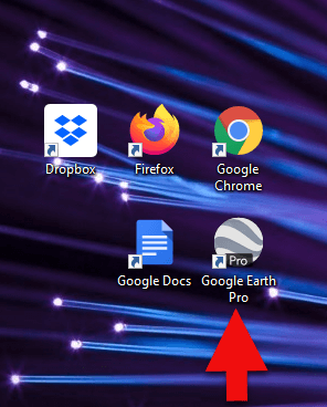
The grey Google Earth globe on the desktop.
If you don’t have it, then you will need to download it.
How to Download the Free Google Earth Software:
- Go to http://www.google.com/earth/download/gep/agree.html
- Click the blue download button
- Read the Terms and Conditions
- If you agree to them, click the Agree and Download button
- Follow the installation guide
- When complete click Run Google Earth
Now that you have Google Earth, you can begin by creating a folder in the Places panel in Google Earth devoted to your 16 couples. Here’s how:
1. In the Places panel, right-click on MyPlaces and select Add > Folder:
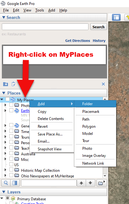
Right-click on MyPlaces > Add > Folder
2. Name the folder and then click OK:
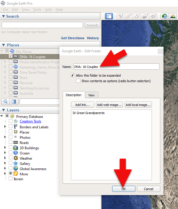
Creating a folder in Google Earth
3. Now you will see your new DNA folder for your 16 couples in the Places panel. If you don’t see it, look toward the bottom of the list. You can move the folder to any location within the list by dragging and dropping it.

Create a folder in Google Earth for DNA 16 couples
Once you have your DNA folder created fro your 16 couples, you can then easily plot your surnames and locations.
How to Plot Your Surnames and Locations in Google Earth:
1. Click your new DNA folder to select it. This will ensure that the placemark you are about to create will be stored in that folder.
2. In the search box (upper left corner of the Google Earth software) type in the first location and click Search. Google Earth will fly to that location on the map.
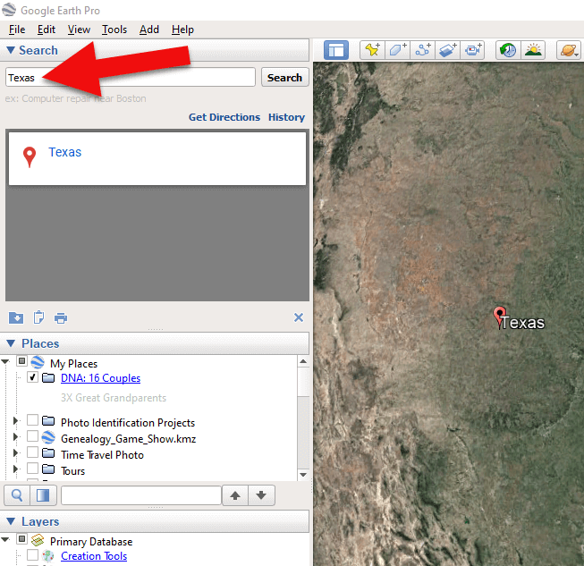
Type the locaton in the Search box and click Search.
3. In the toolbar along the top of the screen, click the placemark button to place a pushpin in that location:
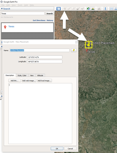
Click the Placemark button in the Google Earth toolbar.
4. In the Placemark dialogue box, enter a title for hte pushpin placemark. Click the OK button to close the box and set your placemark.
5. Repeat the process for all the locations.
Then evaluate the fifth generation of your fourth cousin matches for genealogical information that lines up with any of the items on your list.
You can also plot the surnames and locations of your matches in Google Earth. This is where Google Earth really comes in handy. The free software makes it very easy to see when your ancestral home may be bordering the locations of your matches. Those with whom you find a similarity become your best matches, and your best chance of determining your connection. Those without an obvious connection cycle to the bottom of your pile for a genetic evaluation. You can perform these same kinds of searches for your second and third cousins as well.
As you begin to become more familiar with the fifth generations of your matches, you may also start to see patterns of surnames or locations emerge among your matches. These then become the surnames and locations that might be able to fill the missing spaces in your pedigree chart.
More Genetic Genealogy and Google Earth Gems
If you are new to using Google Earth, I have several suggested resources for you by Lisa Louise Cooke:

Learn more in Premium episode 131.
Here’s a video of the authors discussing three common DNA misconceptions:
Authors: Diahan Southard and Lisa Louise Cooke
by Lisa Cooke | Jan 14, 2015 | 01 What's New, Apps, Canadian, Google Earth, Listeners & Readers
 Awhile back, Barbara from Courtenay, British Columbia, sent me an excellent question about using Google Earth for Canadian genealogy. Then she sent me an excellent answer before I had a chance to answer it myself! Here’s what they were:
Question: “I live in Canada and a lot of the Google Earth articles involving land plats can’t be applied in Canada. The prairie provinces do have a similar land survey system, with townships, ranges and meridians. I found a website where these can be converted to coordinates that Google Earth will recognize. However, this particular website would like to be paid for providing this information (legallandconverter.com). Do you know of any way these numbers can be converted without paying?”
Answer: “I have some good news! My very smart son found a free website,
prairielocator.com, which will give you the coordinates of Section, Township, Range and Meridian for the Canadian prairie provinces. It doesn’t cover quarter sections, but that’s okay if you know which one your ancestor was on. Please pass this along to your Canadian fans or Americans who have Canadian ancestors (there are many, I know).”
Thank you, Barbara–and a special shout-out to your son for finding that resource to help genealogists use Google Earth for Canada research!
Here’s my two-cent’s worth: I just peeked at PrairieLocator.com and I see the site also has an app for the iPhone: Prairie Locator Mobile – for iPhone, by Diahan Southard | Oct 26, 2014 | 01 What's New, Google Earth, History, Maps
When Liberian national Thomas Eric Duncan was diagnosed with Ebola it was unnerving for everyone here in the U.S. As a new Dallas area resident, and someone who was hopping from plane to plane for a Fall series of speaking engagements, it definitely gave me pause.
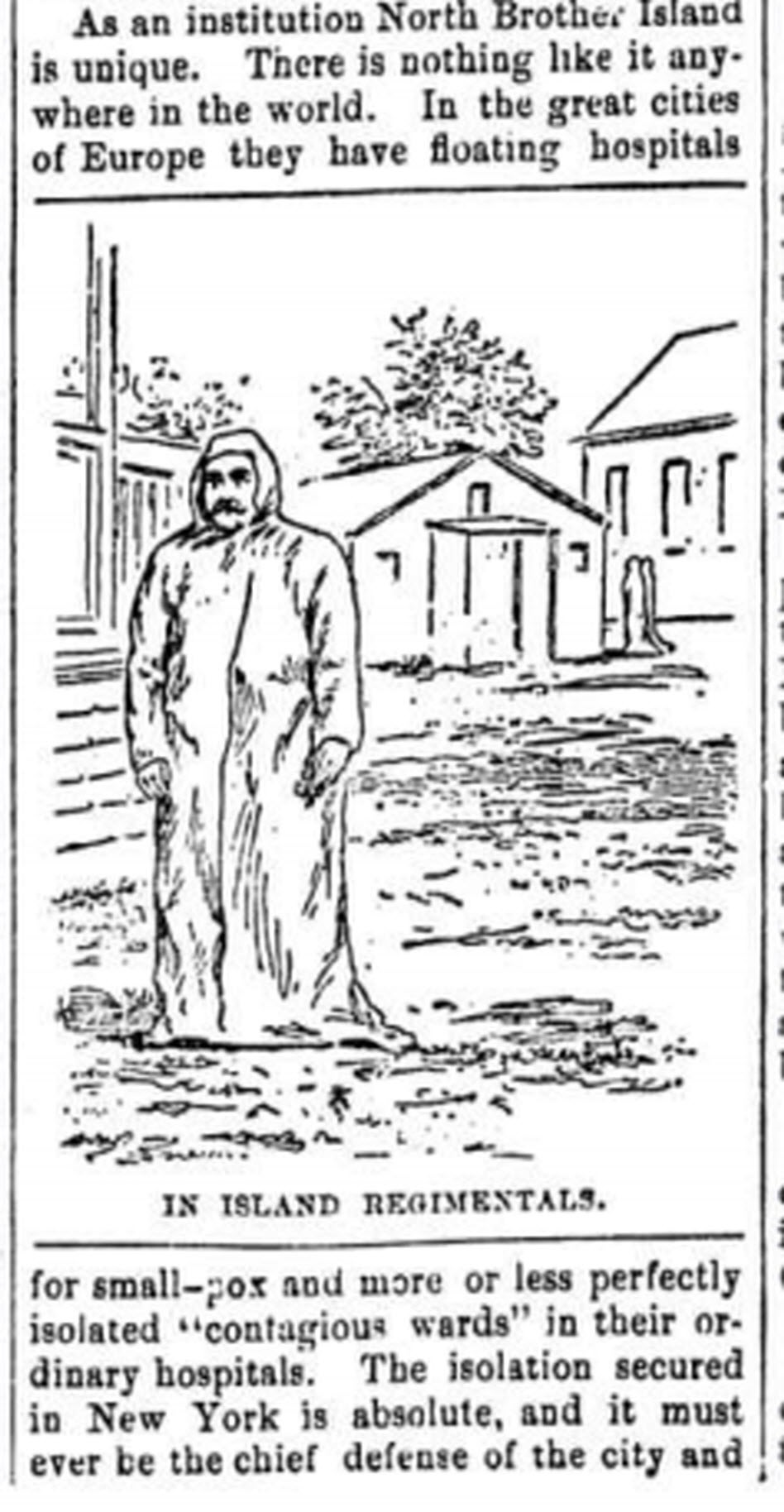
The Abbeville press and banner., October 12, 1892, Image 6/ www.chroniclingamerica.com
Epidemics, quarantines, and communities trying to protect citizens have been age old dilemmas, so it makes sense to look back through history at the strategies employed. There is much to be learned.
If we ask the question “what would have happened if Ebola had struck the U.S. 130 years ago?” we don’t have to look much farther than the location of one of the most recent Ebola patient: New York.
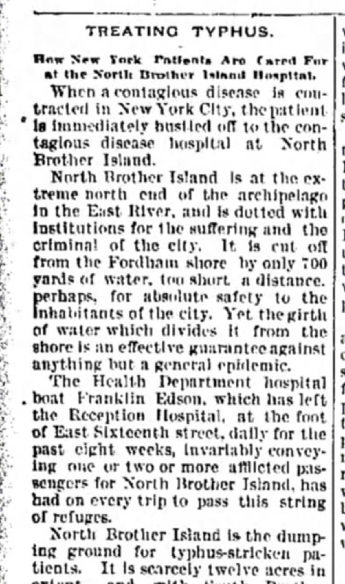
from the Humboldt Republican (Humboldt, Iowa) March 31, 1892
Courtesy www.Newspapers.com
In New York’s East River, tucked between the Bronx and Rikers Island lies North Brother Island, where in 1885 Riverside Hospital was relocated from Blackwell’s Island to isolate and treat small pox patients. From there it expanded to include the quarantine of other diseases.
North Brother Island stands idle today, closed to the public. However from 1907-1910 and 1915-1938 it housed the notorious Typhoid Mary, closing shortly after her death.
Although today the island is closed to the public, anyone can visit virtually with the aid of Google Earth. Join me on a 5+ minute tour of North Brother Island featuring the magazine and newspaper articles of the day, and written, audio and video tours of how it stands today a shell of what it once was. Click here to download and play my Google Earth Historic Tour KMZ file on your computer. It will be added to your “Places” panel in Google Earth under “Temporary Places.” Open the folder and click the “click to play the tour” icon. Be sure your speakers are on! And take time to click to watch the video and view the articles in the placemarks.
Don’t have Google Earth loaded yet? Download it free here.
If you would like to learn to create your own Google Earth family history tours watch this free video and then pick up your copies of Google Earth of Genealogy Volume I and Volume II.
by | Oct 26, 2014 | 01 What's New, Google, Google Earth, Maps
 Genealogy Gems reader and listener Walt has enjoyed creating some exciting family history and genealogy maps and files in Google Earth using the strategies I teach here at Genealogy Gems. He wrote me recently to say that he is thrilled to have a new computer, but he is now faced with how to transfer Google Earth files he created for family history from his old computer to his shiny new one. The good news is that it’s not difficult at all!
How to transfer your Google Earth files:
1. On your old computer open Google Earth
2. All of your files in Google Earth are in the Places panel. In the Places panel, click the small arrow pointing at “My Places” to close it
3. Right-click on MyPlaces and select “Save Place As” from the little pop up menu
4. Name the file OLD GOOGLE EARTH and select where you want to save it on your hard drive. (Saving it to your Desktop will make it easy to find, or just your C: drive. If you use Dropbox, you could save it there and then easily access it from Dropbox on your new computer.)
click “Save”
5. Send an email to yourself and attached the save .KMZ file that you just created.
6. Open the email on your new computer
(make sure you already have Google Earth downloaded on to your new computer)
7. Double click the attached KMZ file to open it
8. Your computer will detect it is a Google Earth file and will open it in Google Earth.
9. The file will be stored in the Places panel under Temporary Places
Click, drag and drop the file from Temporary to MyPlaces
Under the menu click FILE > SAVE > SAVE MY PLACES to save it.
 Want to learn more about using maps in Google earth for your family history research? Watch my FREE class on Google Earth for Genealogy. And we have a 2 disk video tutorial bundle in our store that will walk you through exciting projects step by step.
Genealogy Gems Premium members can also watch my NEW video class online, 5 Ways to Enhance Your Genealogy Research with Old Maps. (Not a Premium member? Learn more here.)
by | Sep 5, 2014 | 01 What's New, British, Google, Google Earth, Maps
 Have you ever found yourself looking for an ancestor’s address that doesn’t seem to exist anymore? Here are some strategies I recently shared via the following Q&A:
Question: From the 1881 Census in England I uncovered the address for my relative: 3 Buckingham Mews, Kensington Place, London, England. When I enter this in the search it gives me 3 Buckingham Mews, Westminster, London,UK.
I don’t know anything about London so I don’t know if this is the same thing but just with current location names. Any suggestions?
My Answer: As with many genealogical questions, this is a question that will likely require several sources in order to answer. I’ve been to London many times and my perception is that Kensington and Westminster are separate areas. Boundaries have certainly changed over the years in London, and England at large though. Here is the direction I would suggest:
1) Google Earth – a search of 3 Buckingham Mews, Kensington actually delivers 3 possible locations (2 in “London” and 1 in “Westminster”). You can save each one to My Places (I would recommend creating a folder especially for this question). At the bottom of the results list you will see an icon that looks like a folder with a down arrow. Click it to download the locations to MyPlaces. Also, be sure to run a search simply on “3 Buckingham Mews” and let Google Earth show you all the possibilities.
2) Go back to your original source: the census. Since there is confusion about the address of your ancestor, look for other addresses listed nearby and plot those in Google Earth. My hunch is that you will begin to build a profile of the census area, and see the relationship between that neighborhood and the 3 results Google Earth delivered.
3) Check Rumsey Historical Maps in Google Earth – LAYERS > GALLERY > RUMSEY (click the Rumsey box). You may need to zoom out a bit to locate the available historical maps. You’ll find that there is one from 1842.
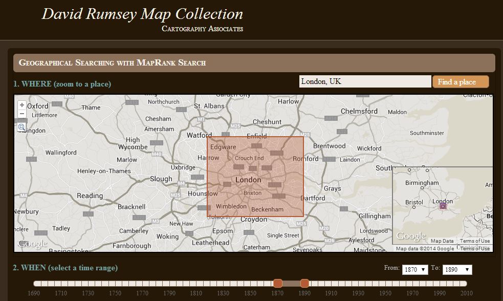
4) Search for applicable maps at the David Rumsey Historical Map Collection. On the home page scroll down and click “Launch Map Rank Search.” From that page you can select London, and then narrow in on the time frame. I would go for a spread of 1870-1890 (see below: you’ll move both pink boxes to set the time parameters on the timeline). There are several excellent maps available to download from that query. Sign up for a free account on the website and you will be able to download the highest resolution maps. You can also, of course, work with the map right on the website.
5) Google Search – Run some searches on the history of London boundaries and boroughs. Here’s a link to a page a found in Wikipedia on “London boroughs.”
By exploring multiple sources you should be able to create a “data visualization” that zeros in on the correct location. I hope you’ll share what you find with me!
Want to learn more about using Google Earth for genealogy? I offer a 2-CD bundle that demonstrates how to:
- download and use Google Earth;
- identify where old pictures were taken;
- explore church record origins;
- plot ancestors’ homesteads and pinpoint their properties;
- create custom historic map overlays;
- save and share images and videos;
- customize placemarks;
- create 3D models of ancestral locations; and
- create unique family history tours. Click here to learn more!