Have you ever wondered how the Internet works? I mean, how data from your computer actually makes to another computer somewhere else around the world? I found a very cool video that really manages to explain a very complex process that happens in a matter of seconds in a way that actually makes a lot of sense. And yet while it made sense, after I watched it it was almost harder to believe that it really works at all because it’s so amazing. Even if you are typically a person who doesn’t bother to click on videos, you have got to check out How Does the Internet Work in the newest of an edition of the free Genealogy Gems Podcast email newsletter.
While the world’s largest online family history resource, Ancestry.com, awaits a possible buyout, they are keeping busy buying other companies. Reuters reported that Permira Advisers LLP has emerged as the front-runner to take Ancestry private in a deal that could exceed $1.5 billion. (Read more about the possible acquisition at PEHUB)
Ancestry also released the following press release about the company’s latest acquisition, San Francisco based 1000Memories. You can learn more about 1000 Memories by listening to my interview with Michael Katchen, Director of Business Development at 1000Memories in Genealogy Gems Podcast Episode 119.
Old maps can tell us a lot more than just where our ancestors lived: They put events into geographic context, reveal surprising genealogical clues, and can be incorporated into Google Earth for analysis and storytelling.
In the newest episode (#92) of the Genealogy Gems Premium Podcast I’ll tell you about a terrific example of a website that has set the goal of have every image they possess (allowable by copyright) digitized and on their website by early 2013
I’m also going to tell you about something pretty shocking that happened to me recently while speaking at an international genealogy conference. I was really taken by surprise, and received some unexpected questions. I will share those with you as well as some solid answers.
It’s another packed episode. If you are a member sign in now to start listening. Become a Member today.
MAILBOX
Stephanie also wrote in with an opinion about Ancestry Trees
“So here are my “2 bits”. I am new to all this and honestly never considered my public tree as published. I have used the Ancestry tree as a if were my workbook, just as if it were a software package like Roots Magic. Because I consider it a workbook I add names as I find them and work the family as a group to document the information AFTER I add them. It simply never occurred to me that others would see this as complete, documented information. I have kept my tree open since I want to be open to contacts. When I see hints from other trees I simply avoid the un-sourced ones. The Ancestry hints have moved me along much faster than I ever could have before. I truly hope others who get angry could see my point of view. Thank you so much for teaching us, you have made this journey so much more enjoyable and effective!!!”
From Loretta: Ancestry Trees
“I’ve had a little different reaction towards the “polluted” online trees… sarcasm. At the beginning of the year I started a blog, Barking Up The Wrong Tree. I post on Tuesdays and Fridays. Both days could be considered tips for beginners but Tuesdays are examples of what NOT to do. All the examples are actual online trees and because of the propensity of newbies to mindlessly copy other trees most examples are not just on ONE tree. It makes for a lot of head meets desk moments but I’m enjoying it. Hope you and some of your listeners will too.”
Ricky in Birmingham, Alabama asks about citing sources and paper and file organization
GEM: New Family History Bloggers
Family History blogging is hotter than ever and the ideal way to get your research out on the web where others working on the same family lines can find you through Google searches! Many of you have been taking advantage of free blogging services like Blogger at Mom Cooke’s nagging here on the podcast, and reaping some rewards. So let me highlight a few listeners who have turned in their “Round To It” for a “Gitter Done!”
First up is David Lynch who started a blog on his St. Croix research
“I recently started in my genealogy and find your show both entertaining and helpful. My 200 Years in Paradise
The reason I’m writing is that sometimes we forget that the world wasn’t homogeneous throughout the 1800s. Right now, I’m writing a series on illegitimate births on the island of St. Croix from 1841-1934. From my research, it seems that over 77% of the children born were to unmarried households. Typically they formed stable family units, but just didn’t marry. In fact, in my personal family history, I have a set of ancestors who had 16 children and got married after their 12th child was born. In the US at the same time, only about 4% of the children were illegitimate.”
Jennifer shares her blog
“Just wanted you to know that I’ve started my own blog, based largely on the encouragement in your podcasts. What appealed to me was that it’s a medium where I can share information, but not in a way that’s an online family tree. This will prevent readers from copying and pasting family tree branches, without slowing down to learn some context. It also allows me a forum to correct some gigantic errors floating around out there about my ancestors. I finally woke up to the fact that I’ve moved to the head of the line in the experience department. I’ve placed a lot of tags on the entries, so the information is easily located in Google.” http://jenongen.blogspot.com/
Sonja Hunter wrote in to share her blogging success
First, I would like to thank you for putting together your podcasts!…I only became a listener about a year ago, but have been working my way through old Genealogy Gems podcasts as well as the Genealogy Made Easy podcasts, mostly while gardening.
I also wanted to let you know you inspired me to start blogging. I rang in the New Year by starting a blog about doing genealogy in my hometown of Kalamazoo, Michigan. One primary goal is to highlight helpful area resources. I imagine this will be most helpful to those new to conducting family history research in the area.
In addition, I am trying to include Kalamazoo area or Michigan history items that I think are interesting. One example is an article I found in the local paper describing what Kalamazooans from 1884 imagined life would be like in 1984. I’ve also written about poisonous cheese in the 1880s, diphtheria and the case of my gg-grandfather’s brother-in-law who may or may not have committed suicide by slitting his throat. I consulted Paula Sassi for that case and plan to blog about her handwriting analysis in the future.
Thank you for inspiring me to embark on this project! I’m learning a lot. And keep up the good and valuable work you do on your podcasts!
From John in Maryland:
“I want to thank you again for everything you do to inspire people to be enthusiastic about their family history. I learn so many “Gems” within all of your resources and put many of them to practice. You are the family history “Go-To” person in my book. I recently started a blog for the primary reason of documenting my findings so that I wouldn’t forget what I’ve been discovering. The blog also appears to be a good way to share my success stories with others that may be interested. I credit you for introducing the idea of using a blog in Family History: Genealogy Made Easy podcast. When I first listened to the podcasts about blogs, I didn’t think it was something that was applicable to me, as I felt I had no new information to share with others since many experts like yourself already handle this. However, I’m giving it a try and enjoy it so far. I really like how I’m able to place images within the text to help convey my information.” http://recordetective.blogspot.com/
And finally Shannon Bennett has really made a blogging splash. She writes:
“I have been hemming and hawing on writing to you and finally took the plunge to do it. Last spring a friend of mine told me about your podcasts (yes all of them) since I had just started into family research. She thought I would like it, and boy was she right! I have taken you on my iPod to drop my kids off to school and pick them up again, cleaned house, grocery shopping as well as everywhere in between. The wealth of information I have gathered from your podcasts have been very helpful, and I have loved all the interviews and tid-bits that have come along the way as well. There is no way that I could just pick one out of so many to be my all-time favorite. Maybe a top 10 list would cover it.
However, I do have to blame you for the latest adventure in my life, which is why I am writing. Listening to you tell us, in almost every episode, about the importance of having a family blog finally sank in. The first couple of times I heard you say it I thought to myself “there’s no way I would/could ever do such a thing, I barely have time to keep up with my Live Journal account.” A few weeks went by and the thoughts began to change to “hmmm…maybe I could do this.” Then after 4 months of thinking about it I started to do some research into how to run a successful blog.”
Shannon took the plunge and applied to Family Tree University to write for their Family Firsts Blog. “I come to find out that they are looking for their second blogger. I sat…I thought…I clicked the application button. Yes, on a whim I entered because I thought I had nothing to lose. You see I never win these types of things.
A month goes by, and I have given into the feeling that well it was a good try but of course I didn’t get it.…then later on that week I find out I won it!
So thank you, I never would have entered let alone thought about creating my own blog less than a year into my family research, without you and your wonderful podcasts.”
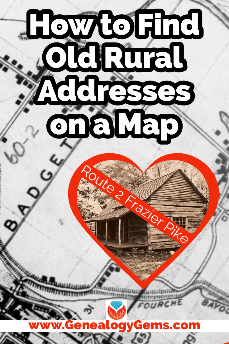
Have you ever found an address for an ancestor but been disappointed that it is just a Route number and a town name? Have you wondered if it is possible to figure out where they actually lived? The good news is, it is! I’m going to show you how to take a rural “route” address from the early 20th century and find it on an old census enumeration district map.
(This article contains affiliate links for which we may be compensated. Thank you for supporting our free content.)
In a recent video I showed you how to find 1950 Census Enumeration District (ED) maps. These are super helpful and also free. In that video we used the address of an ancestor that we found by hunting through old letters and documents. But for many Americans in the early 20th century that address may have just been a route number and town.
That was the case for my viewer Lisa. She emailed me after she watched the video. She writes, “How can you find the E.D. number when you only have a Route number? My relatives lived in rural Arkansas.”
This is totally doable! Follow allow these steps of this case study and they will help you find the E.D. number and census enumeration district maps, and zero in on the location.
“Route 2” & Rural Delivery
A carrier route is basically the territory one letter carrier can cover on a daily basis. So, there could be a Route 1 or a Route 2 in thousands of places around the country. It just happens that your ancestor was on, say, Route 2 in a particular township area. Although it doesn’t tell us which house, it does dramatically narrow down the place because a daily route was the same and may not have been that large. Once we find that area we can then use other sources to help us try to get even more specific.
The first thing we need to do is gather some details. We need:
The ancestors’ names
The Route number address which includes the town
The county – which is something we can easily find online with a quick search
The year – in this case the address she has is from 1950.
So, here’s what Lisa sent me about her ancestors, the Blazers:
Names: Joseph Madison Blazer and Minnie Blazer
Route number: Route 2
Address: Frazier Pike
County: Pulaski
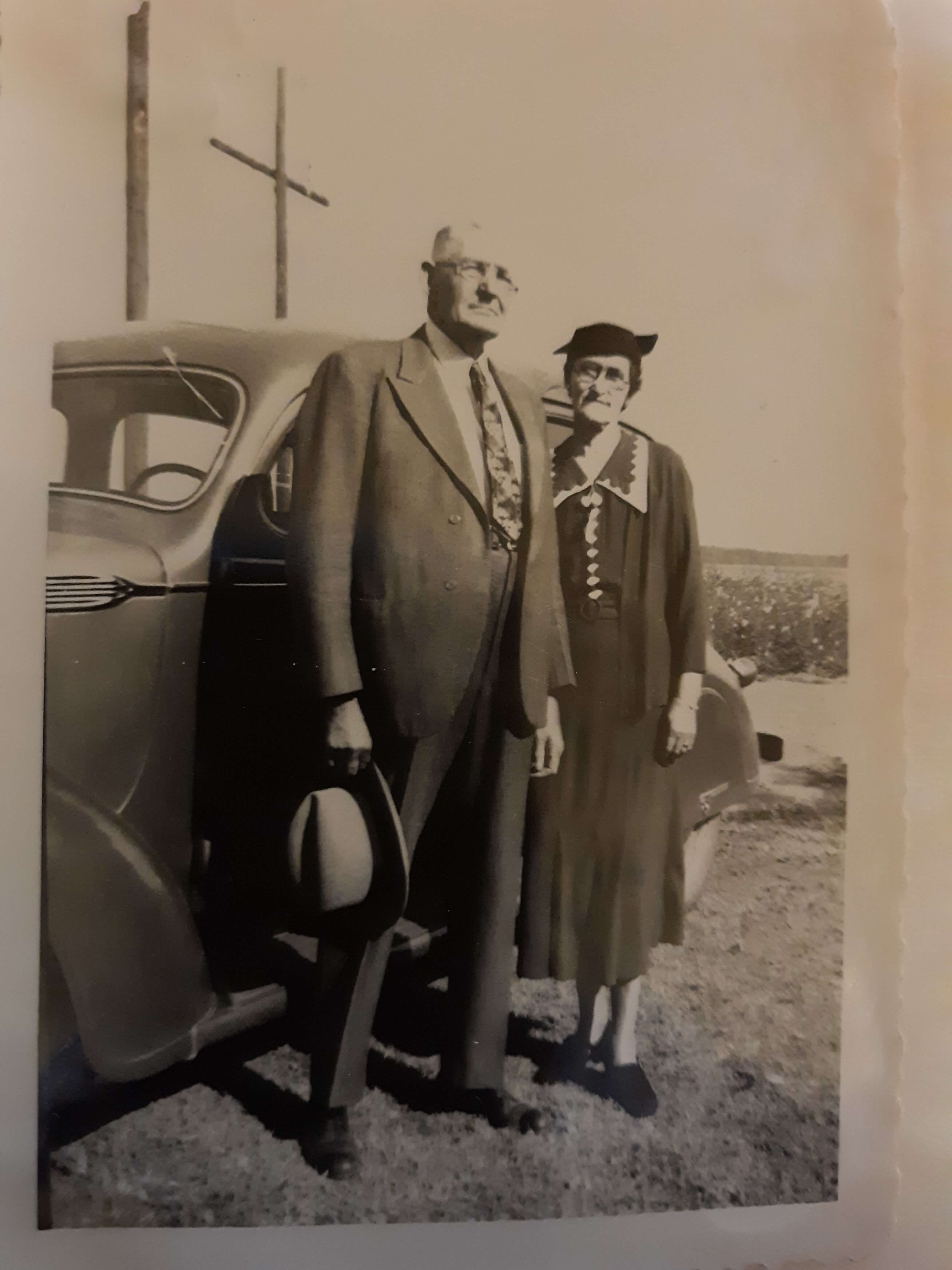
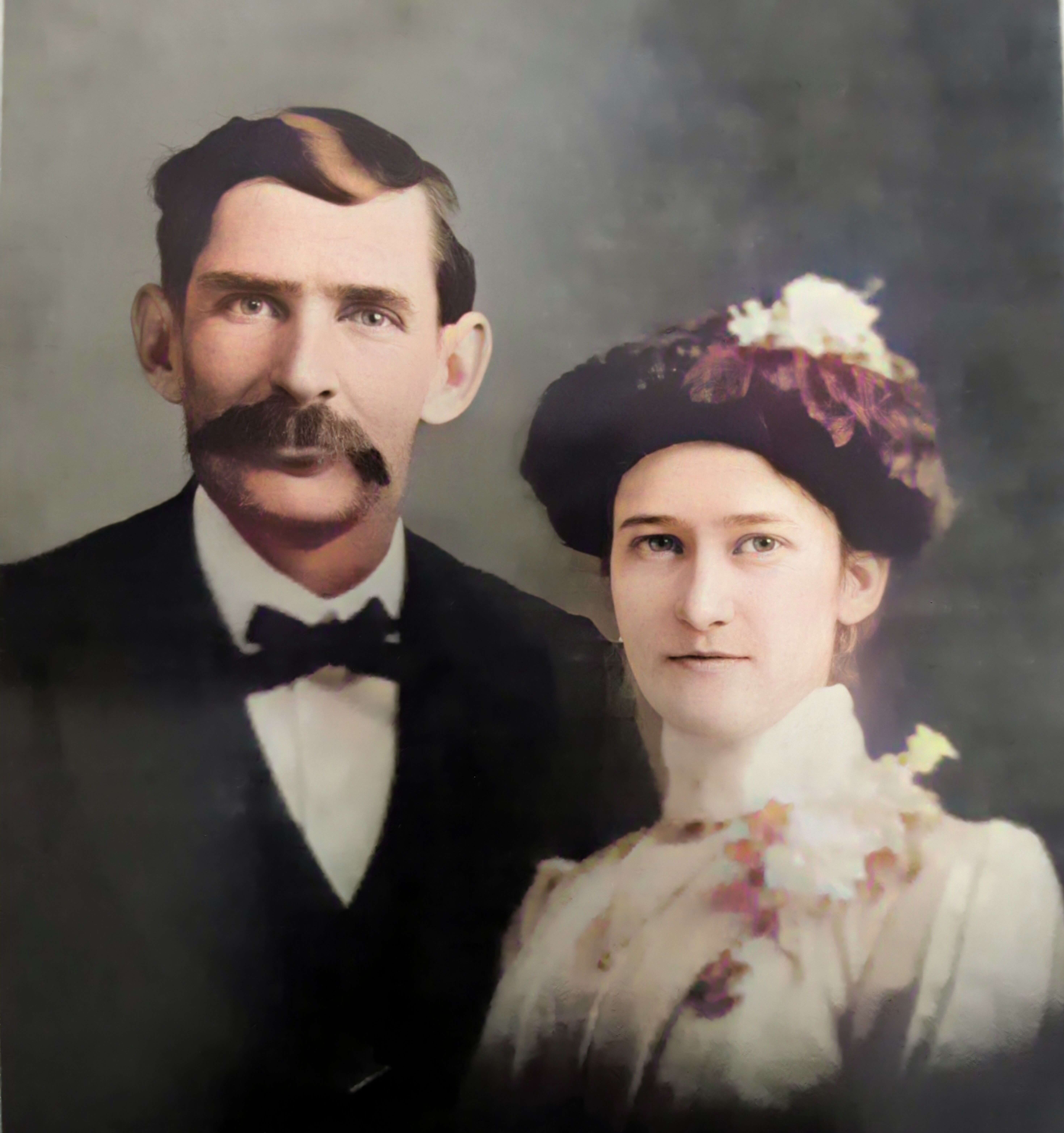
Joe and Minnie Blazer c1950 (Image courtesy of Lisa Egner.)
Step 2: Find the Family in the Census
Now we need to find the family in the census record closest to the date of the known address.
Since the 1950 census hasn’t been released yet because I’m recording this in Jan. of 2022, we can’t yet pull up their record. So, we’ll need to turn to the 1940 census. There’s a good chance that the family was in the same location since folks didn’t typically move around quite as much or as far as we do these days.
The 1940 census is available for free at many of the larger genealogy websites like FamilySearch and Ancestry.
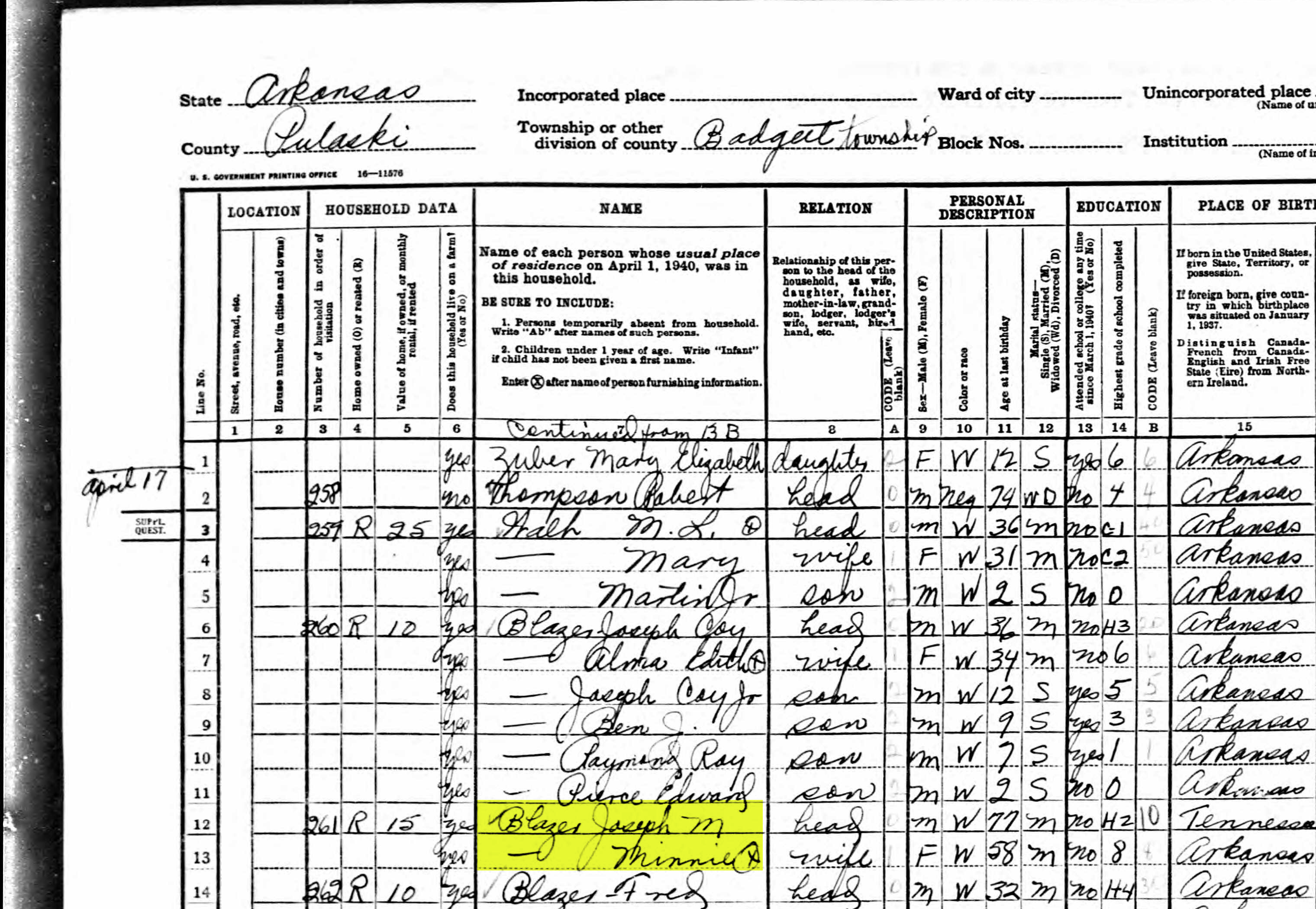
Here’s the Blazer family in the 1940 census, and Lisa confirmed that she believes this is the same place.
On the census record we are looking for three very important things:
the township (Badgett Township)
the ED number (60-2B)
and any address written along the left margin. If you don’t see anything, check the pages before and after that page. (Frazier Pike)
Step 3: Search for the Township
Once you have the location or township, search for them in an online map. I prefer to use Google Earth, but I often also use Google Maps. It doesn’t hurt to check both.
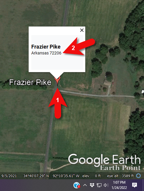
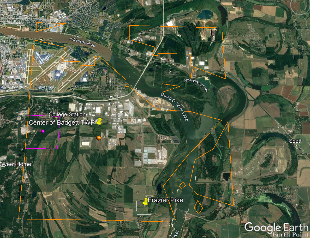
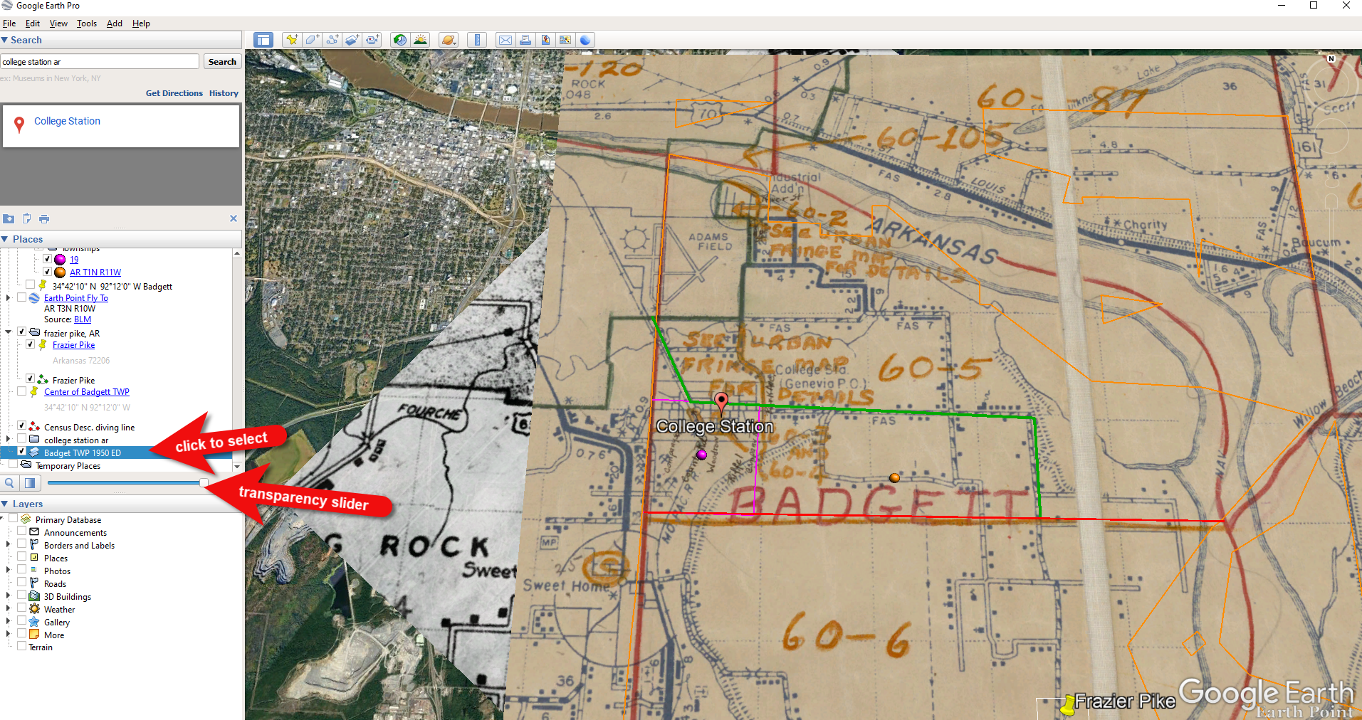
In this case we have two locations to look for: Badgett Township and Frazier Pike. We’ll start with the actual address which was Frazier Pike, Arkansas. Google Earth tell us that it’s a road just southeast of Little Rock, AR. When you click the pin it also tells you the current zip code for the Frazier Pike area, so we’ll make note of that. I’m like to create a project folder (Blazer Address) in my Places panel and then save the location pin in it. I will add additional items to the folder as I find them.
Click the pin to see the zip code.
Next, I’ll search for the other location found in the 1940 census, Badgett Township. It doesn’t appear in either Google Earth or Google Maps. That’s probably because it’s been renamed or incorporated. Googling may be able to help so I googled: badgett township arkansas history.
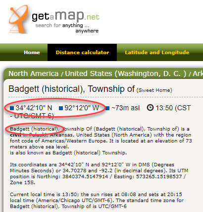
This led me to a website that provided several helpful clues. It says that Badgett is “historical”, meaning that it’s the old name of the town which has since changed. It also provides us with the latitude and longitude of Badgett which we can use in Google Earth to confirm it’s location.
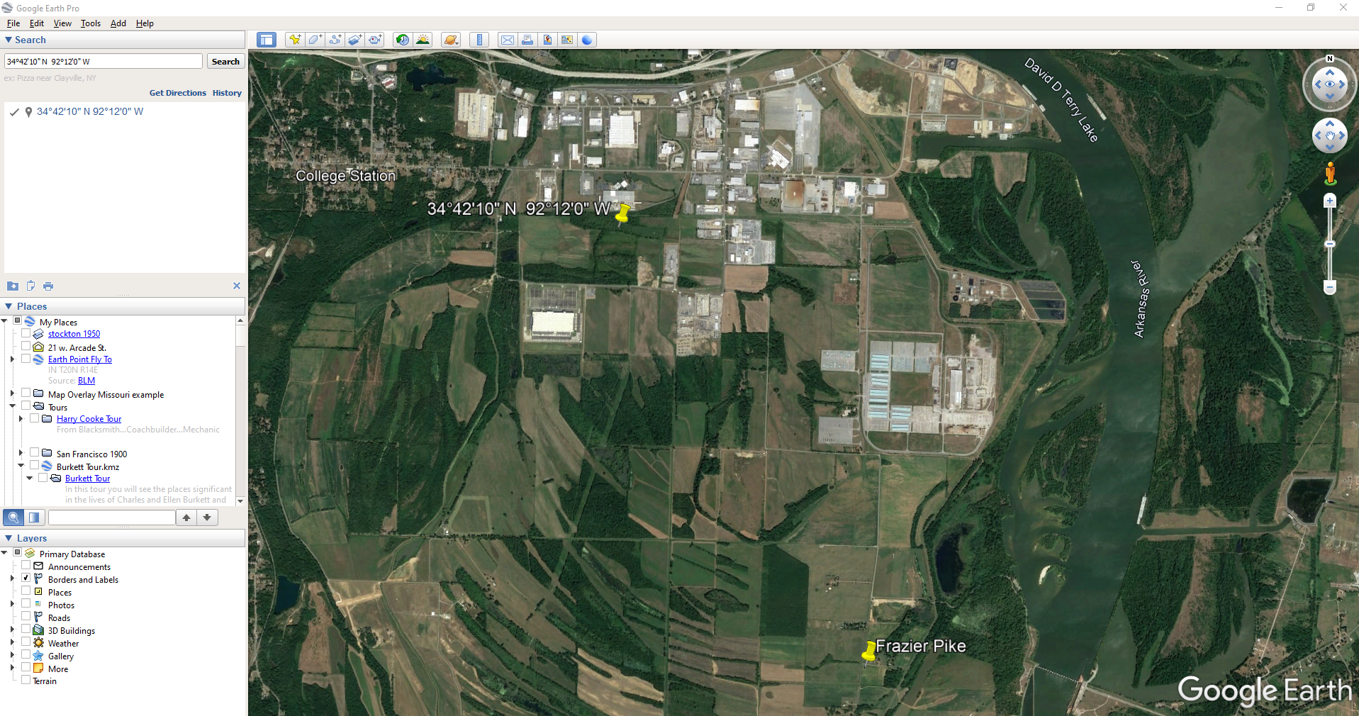
Go back to Google Earth and enter the coordinates (34°42’10” N 92°12’0″ W) in the search box and press ENTER on your keyboard.
The locations are very close.
And indeed, it’s very close to Frazier Pike. (image above)
I also like to look at the image results when googling. The website results are organized by the most relevant images. When I ran a search on Badgett, AR, and click Images on the results page, I see that the first one showed a map showing Frazier Pike. So, they are nearly one and the same.
Another search result was theHome Town Locator website. It says “the Township of Badgett (historical) is a cultural feature (civil) in Pulaski County. The primary coordinates for Township of Badgett (historical) places it within the AR 72206 ZIP Code delivery area.” This confirms that it is historical, the coordinates pin the same place on the map, and the current zip code is the same.
A quick Find on the page search (Alt + F) for Route 2 jumps me to a nice bit of history.
In the section discussing schoolhouses we get a description of the route: “…located in the main red-dirt road called Route 2 in Pulaski County. Route 2 is now known as Frazier Pike.”
Step 4: Find the ED Map for the Closest Census
Next, we turn our attention to the enumeration district or ED number we found on the 1940 census. As you’ll recall, 1940 is the closest available census record to the date of the address, and we found Lisa’s ancestors in that record in Badgett, AR which we now know is the Frazier Pike area in Pulaski county. On that record it says: Badgett Township. ED 60-2B.
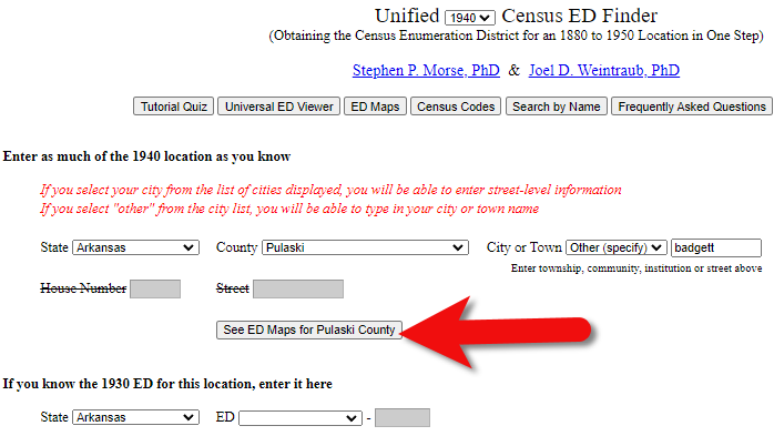
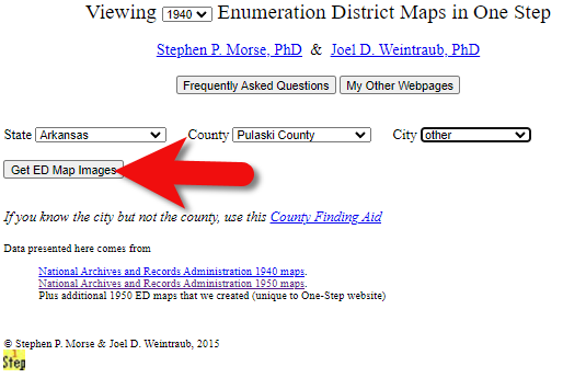
We could google for the year of the census and the words enumeration district map. However, there’s a great free tool for finding them over at Steve Morse’s One-Step Tools website at stevemorse.org.
In the menu under U.S. Census select the Unified 1880-1950 Census ED Finder, select the year at the top of the page. In this case we will select 1940. Next, enter the state (Arkansas) and county (Pulaski). You can then select the city or town. However, in the case of rural addresses, don’t expect to find the town listed. If it offers you an “Other” option you can try and type the name of the town (Badgett) in the field provided. Don’t bother entering the route number (Route 2) because that’s not a street address, it’s a postal delivery address.
We could also run this same search on the 1950 census. Chances are you will see more ED numbers listed because the population was growing. Since an enumeration district had to be the size that one enumerator could cover in about a two week timeframe, they were often redivided as they decades went by.
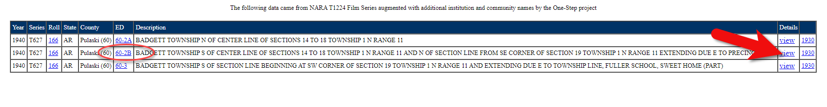
Since we know from the 1940 census that township was in existence, we should receive a list of ED numbers as a result. In this case we got three: 60-2A, 60-2B. and 60-3.
Click the corresponding ED number.
Click the linked ED number that matches the one you found in the census record. In this case, the 1940 census record told us that the Blazer family was in ED 60-2B, so we click that link.
The next page lists each ED. Click the View link for the ED.
Click the View link.
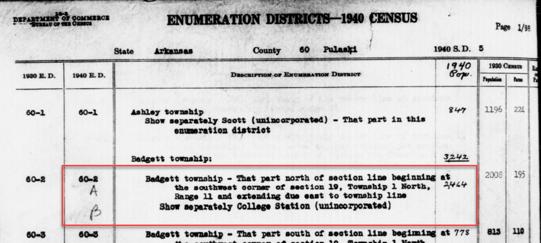
The View link will take you to the exact page for that ED in the ED Descriptions from the National Archives T1224 microfilm from Record Group 29. This description helps even further define the area.
1940 Census ED Description
60-2 A and B says, “Badgett Township – That part north of section line beginning at the southwest corner of section 19, Township 1 North, Range 11 and extending due east to township line. Show separately College Station (unincorporated.)”
This is perfect because its’ giving us the township, range and section! We can use this information to plot it in Google Earth.
How to plot a land description in Google Earth with Earthpoint:
Enter the state, principal meridian (in this case there’s only one choice here thankfully), township, range and section numbers from the census description.
Click the Fly to on Google Earth button.
This may open automatically in Google Earth or you may be prompted to save the file to your computer. Do that and then click it to open. It is a KMZ file so it will automatically open in Google Earth.
And here are the results! The location is mapped out for you.
Census description mapped in Google Earth.
Notice I still have my placemark pins for the approximate location of Frazier Pike, and the center of Badgett Twp which we got using the latitude and longitude coordinates. Section 19 is outlined in purple, and the township is outlined in orange.
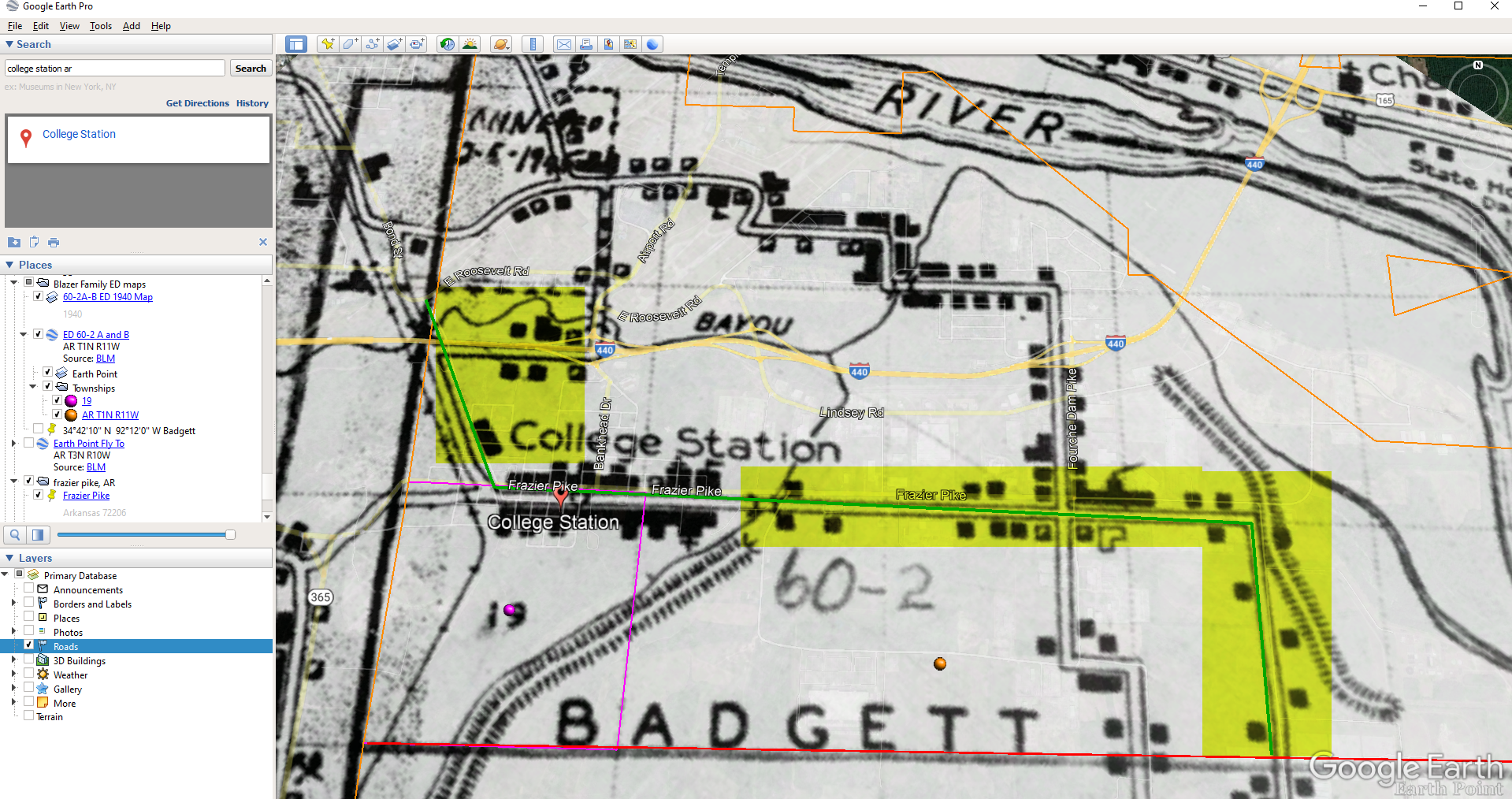
Since Frazier Pike is a road, turn on Roads in the Layers panel. Now we can see that Frazier Pike is running north and south and our pin is right on top of it.
Now we can use the census description to further zero in on the area. “Badgett Township – That part north of section line beginning at the southwest corner of section 19 Township 1 North, Range 11 and extending due east to township line. Show separately College Station (unincorporated.)”
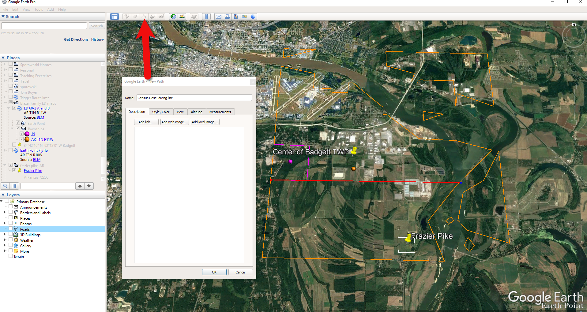
Mark that in Google Earth using the Path tool. Click the Path button in the toolbar at the top oof Google Earth. Click on the southwest corner of section 19 (outlined in purple) and then go east and click the township line (in orange.) Give your path a title and click OK.
Click the Path button in the tool bar.
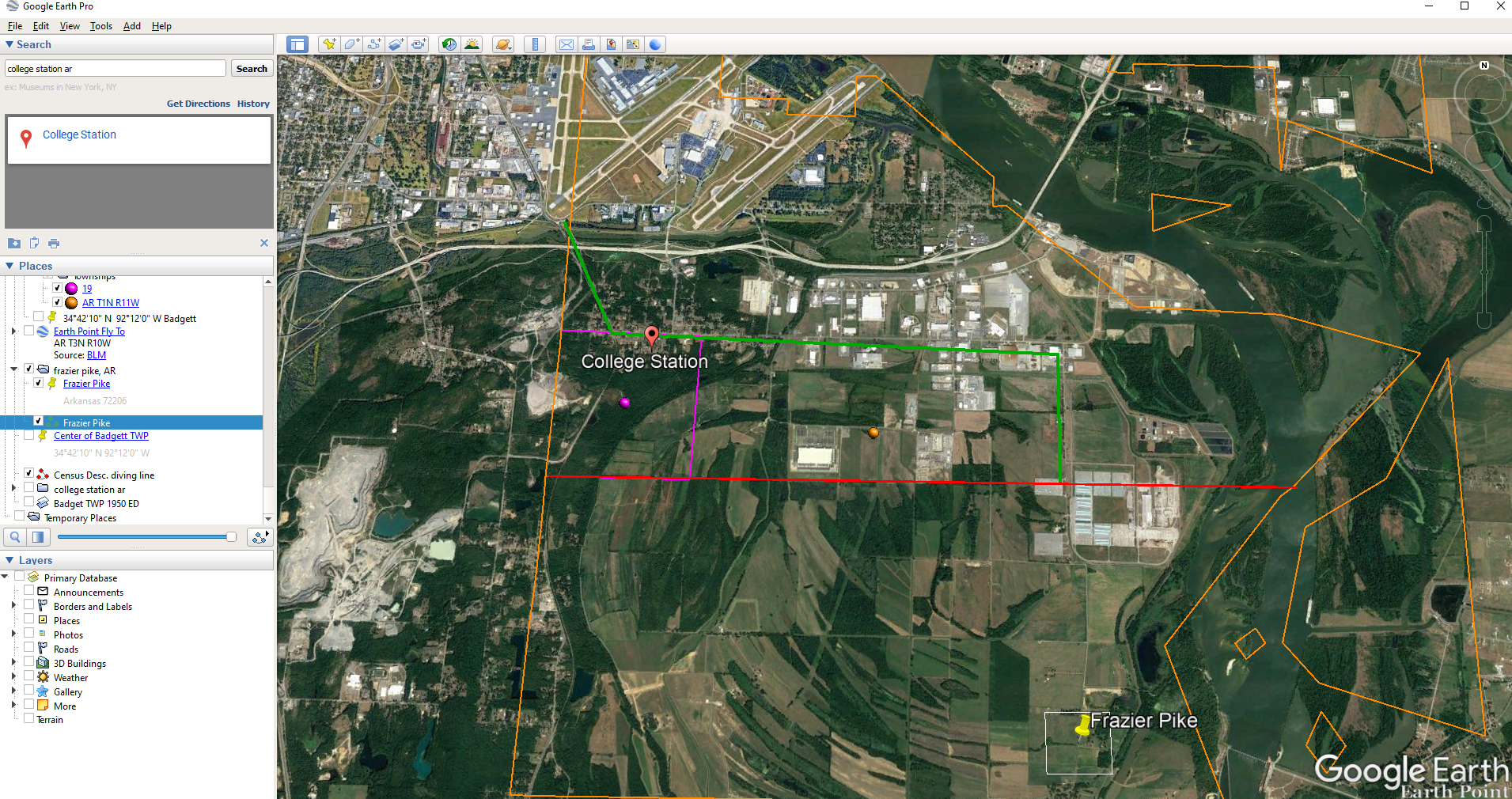
Next in the census description, on the same line as “B” it says “Show separately College Station (unincorporated.)” We can find College Park by searching for College Station, AR in the Google Earth search box.
Next, we want to follow Frazier Pike going north until we are above the section line that started in the southwest corner of Section 19. Use the Path tool again to mark it on the map.
Use the path tool to draw lines in Google Earth.
Get the Enumeration District Map
Now it’s time to head back to Steve Morse’s website and get the ED map for 1940. On the page you started your search, click the See ED Maps for… button.
Click the See ED Maps button.
On the next page select the state, county and city again and click the Get ED Map Images button.
Click the Get ED Map Images button.
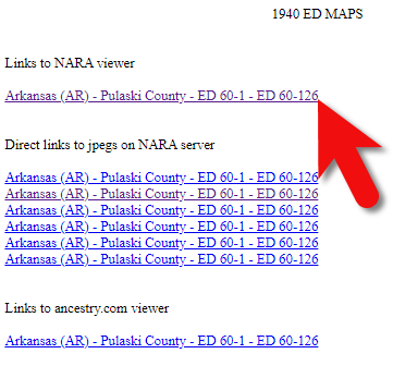
This will take you to a list of all of the available maps. The first link will take you to the National Archives webpage where you can look through all the maps for the area you selected. You could also look through all the individual maps by clicking each of the links listed under “Direct links to jpegs on NARA server”. However, I don’t recommend that will take longer because they are extremely large image files. It’s easier to quickly look through them on the NARA website.
Click the Link to NARA viewer.
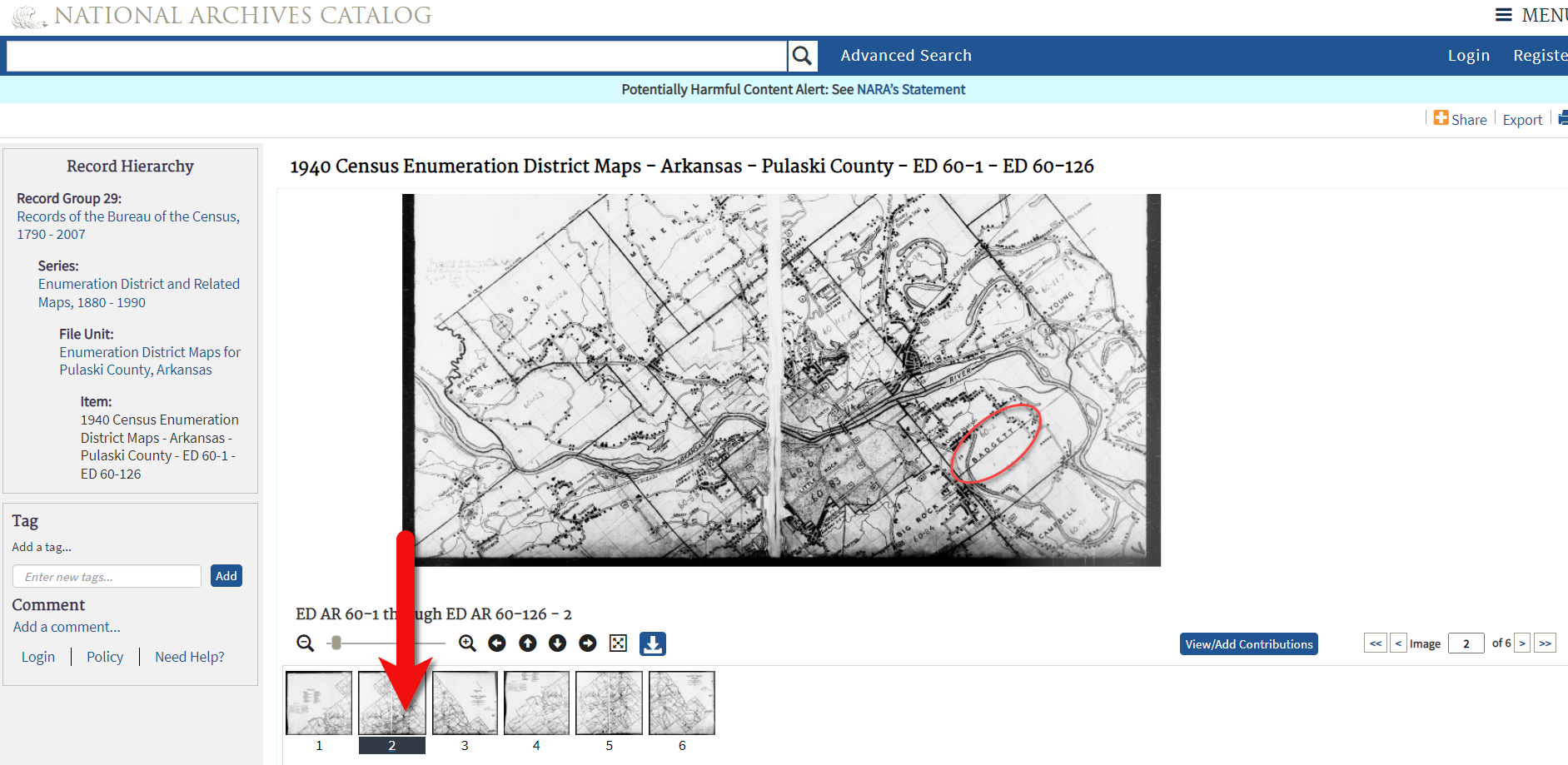
Click the link to the NARA viewer and look for the township name in the map thumbnail images. In this case I’m looking for Badgett. You can do this quickly by clicking each image and then drag the larger map in the viewer around with your mouse. I found Badgett Township in the second map.
Map images at NARA.
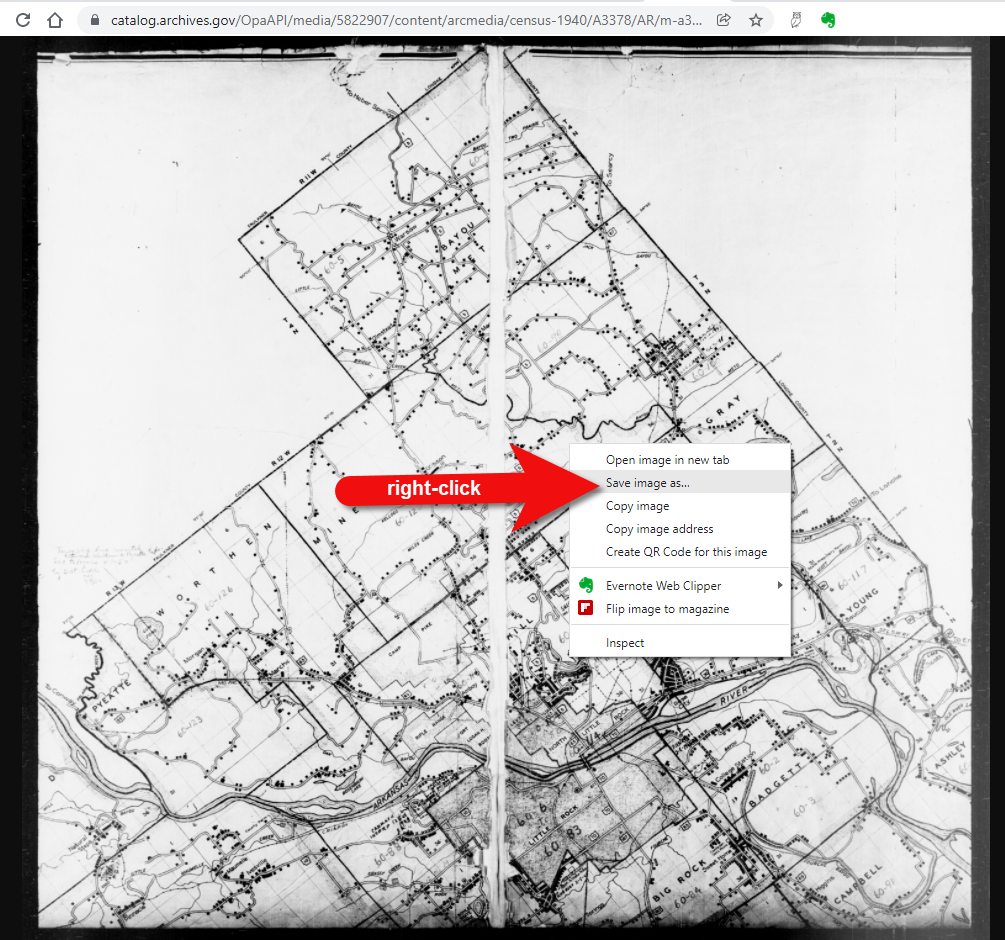
Download the full-sized map by selecting the thumbnail image and then clicking the download button (down arrow.) The full resolution map will load in your web browser. Right-click on it and Save Image As to save it to your computer.
Right-click on the map to save it to your computer.
It can help to create a map overlay in Google Earth using this map. (Learn how to do this in the newest edition of my book The Genealogist’s Google Toolbox.) I cropped the image to just include Badgett Twp.
In fact, you can overlay both the 1940 and 1950 ED maps. Click to select a map in the Places panel and then you can use the transparency slide to fade it to reveal changes.
Select the map and use the opacity slider in Google Earth.
Step 5: Follow the Census
The census can provide even more clues about where in an enumeration district an address was located. Using the census record and the census description of the enumeration district, it can help to highlight the area of the map. In this case, ED 60-2 is “that part north of section line” which I marked with a red path line. The Blazers address was Frazier Pike (which I marked with a green line), so this eliminated the northern area and the Fourche Dam Pike road. To make sure that I could eliminate that area, I verified in the 1940 census that Fourche Dam Pike was enumerated separately by running a keyword search of the Pulaski County census records at Ancestry. And yes, indeed folks living along Fourche Dam Pike were enumerated separately and the road was written along the margin just as Frazier Pike was. This gives me a lot of confidence that I’m identifying the right area.
The route highlighted on the census ED map.
As you can see, there are little black squares and other markings on the map. To find out what each of those means we can turn back to the National Archives and download the page from this map collection that includes the map key.
The black squares are “Farm Units”. A farm unit square is not one family , it is the entire farm, including the owner and other families who may live and work on the farm. We also see businesses, churches, the town hall, school houses and more. We may not be able to find the exact home, but it’s possible to get very close. To do that, we need to head back to the census records themselves.
On Ancestry.com , the Blazers appear on Image 27. The filmstrip makes it easy to quickly scan through the images and browse them.
In this case, there are about 33 images or pages in ED 60-2B. The enumerator would start at one end of Frazier Pike and then make her way to the other. The enumerator wrote “College Station Pike” on pages 1 and 2. That isn’t a road today, and I couldn’t find any references to with a quick search. However, all of the other pages say, “Frazier Pike”. My guess would be that the census taker started on the west side – the hub of College Pike – and made her way east. Census enumerators visited homes and farms in a logical path, although they may have criss-crossed back and forth across the road. They listed the order in which they visited on the census form itself. In cities we might also see house numbers listed, but that’s not the case in a rural area. However, you may see pencil dots with visitation numbers written on the ED map. They were instructed to do this in rural areas in the census enumerator instructions in 1940. Unfortunately, the person enumerating 60-2B did not.
We could also look at the types of businesses and buildings shown on the map, and then look through the census records at occupations. We see a “factory/industrial” building to the east so we would look for people working in that environment in the census and see where they are living. We see a denser population in College Station along with a schoolhouse and two churches, so it would be worth looking through the census pages to see where the school teacher and pastors are listed. Folks may not have lived on the premises, but it would make sense they lived near their work.
Wedding photo Joseph Madison Blazer Minnie Mae Peters (courtesy of Lisa Egner)
And finally, we want to look for renters and owners. If a family rented, a capital “R” was entered on the census. Those who owned their property were listed with a capital “O”. Since the black squares are “Farm Units” we wouldn’t expect to see a square on the map for every house. If our hypothesis is that the enumerator started on the west side, we could count the number of owned dwellings listed in the census until we get to the family living in question. Then we would count them on the map, going east. Again, it’s not exact, but it’s a whole lot more than what we knew about the address Route 2 Frazier Pike when we started!
Old maps are vitally important for genealogy because the characteristics of a location can change in many ways over time. Historic maps help us understand the world as it was at the time our ancestors lived.
Here is a short list of just a few of the things that may have changed:
Street addresses
roads
town names
county boundaries
waterways that may have been filled in or opened up
railway lines
In fact, the country itself where they lived may be a completely different country. For example, my German ancestors lived in Prussia in the 19th century. Today, that area is part of Poland. Therefore, all of the village names have been changed to Polish names.
The David Rumsey Map Collection is an excellent place to go to find maps of your ancestors homeland for free.
Watch the Map Search Video
I’m going to explain the 7 steps to finding the maps you need for your genealogy research at this wonderful website! I highly recommend that you watch the short video below to see it in action as you read. The player will stay with you as you scroll down the page.
Step 1: Go to the David Rumsey Map Collection Website
The first thing you need to do is go to the David Rumsey website here. You’ll be greeted on the home page with glorious historic maps. (Stay focused because it’s easy to get distracted by all the fascinating maps!)
Scroll down on the David Rumsey website home page.
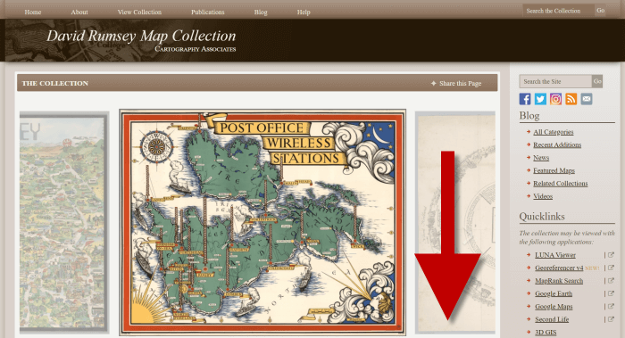
Step 2: Scroll Down to the Bottom of the David Rumsey Home Page
While you can search for a place name in the search box at the top of the page, there’s a better way to search. Scroll down the page until you get to Featured App: MapRank Search (it’s almost at the bottom.)
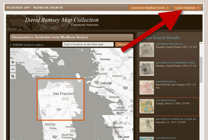
Step 3: Launch Map Rank Search
The Featured App – MapRank Search is the best place to search the website, but it’s easy to miss because it’s not at the top. So go ahead and click the Launch MapRank button in the upper corner of this section.
In the Featured App: MaprRank Search section click the Launch MapRank button
When you click the button it will open a new tab in your web browser which will take you to the Geographical Searching with MapRank Search page.
Quick Tip: The Fastest Way to MapRank Search
You can get there faster by going directly to https://rumsey.mapranksearch.com. I didn’t take you straight there from the beginning because I think it’s important to be aware of the home page and everything else it offers. However, today our focus is conducting the optimal search for old maps for you family history.
Step 4 Selecting the Map Time Frame
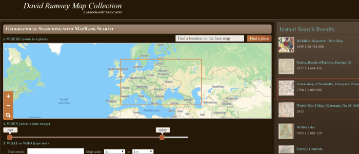
Here’s what the search page looks like.
The DavidRumsey.com search page
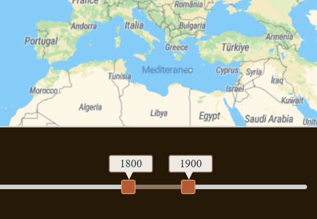
There are two very important features on this app page that will help you get the best results possible: the time slider and the location search box.
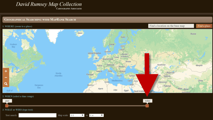
The time slider is located beneath the map:
Time Slider for searching maps by time frame
It’s important to first select the time frame that you are searching because that will dictate the results you get when you search on the location name. (We’ll get to that in just a moment.)
There is a slider on each end of the timeline. Slide them to specify the desired time frame. In my example below, I’m looking for maps between 1800 and 1900.
Searching for maps between 1800 and 1900
As you move the sliders, you’ll notice that the maps in the right hand column will change. This is because only maps that fall within the range you select will be offered in the Instant Search Results column. But before we look at those, we need to type in a location in the next step.
Step 5: Selecting the Location
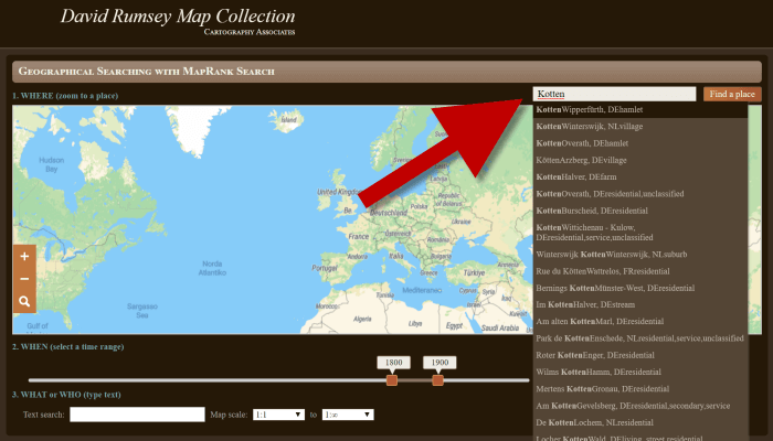
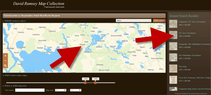
With your time frame selected, now you’re ready to type the location in the search box.
As you type, the app will make suggestions. But wait! Before you click the Find a Place button to run the search, look carefully at the list of suggested locations that may appear. Many locations names can be found in different areas. That is certainly the case with the name of the tiny village where my great grandfather was born: Kotten.
Type the location name to search the maps
In fact, the list doesn’t even include the Kotten I am looking for.
In cases like this, it is best to search a little more broadly. When Kotten was part of Prussia, it was located in Kreis Johannisburg so I could try searching for that. Even better might be to search for the largest city in the area since Kotten was such a tiny village. Arys was the largest city in the area.
Once you type in the name (and select from the suggestions if needed) click the Find a Place button just to the right of the search box.
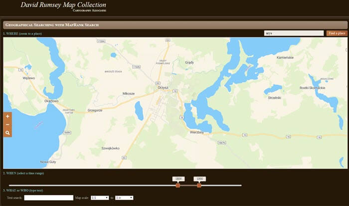
Step 6: Analyze the Map Results
In my example of searching for the city of Arys (which is the name it was known by in the 19th century when it was part of East Prussia) the modern-day map displayed is actually Poland.
My search resulted in a map showing Orzysz, Poland
However, the David Rumsey website does a good job of cross-referencing the older German names (Arys) with the new Polish names (Orzysz). This is another reason why searching for a larger city works well. Larger cities are more likely to be in the David Rumsey system for cross-referencing, and of course they are easier to spot on the map. Generally speaking, the location you searched will be in the center of the display map.
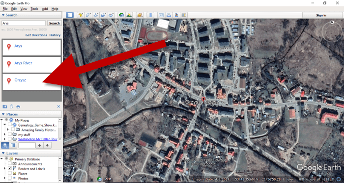
Quick Tip: Verifying Location Names
Another quick way to cross-reference location names (or verify your findings in David Rumsey) is by searching for the name in Google Earth. In the example below, I typed in the Prussian city of Arys. Google Earth will offer options if more than one matching result exists.
I was a bit surprised to see “Arys” as one of the three listed results since it is not called that today. When I clicked Arys it took me to the city of Arys in the Turkistan Region of Kazakhstan, far away from Poland! Clicking Orzysz in the results list took me to the area of Poland that was once East Prussia. This confirms the results I received at the David Rumsey website.
Now it’s time to review the map results listed in the Instant Search Results column on the right. Isn’t it fantastic that David Rumsey’s website not only presented me with the correct Polish location, but also maps published between 1800 and 1900 that include Arys? I think so!
Map results appear in the column on the right side of the page.
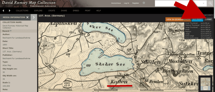
Click the map you think best suits your needs. The map will open in in a new tab in your web browser. (These browsers tabs provide a nice bread crumb trail for your searching activities.)
All of the source information about the historic map that you chose will appear in the column on the left. (See the image in Step 7.) If you decide to use this map you’ll definitely want to accurately cite the source. Learn more about the importance of source citations here.
Step 7: Export the Map
I was delighted to find the village of Kotten on this map of Arys published by Reichsamt fur Landesaufnahme in 1893!
When you find a map that you would like to use for your family history research, export it to your computer. To do this, click Export in the upper right corner of the map and select the desired size. You can select a size ranging from Small Thumbnail to Extra Extra Large. Keep in mind that the larger the size, the more clarity you will have as you zoom in closer and closer. This is very important if you plan on using the map in an overlay in Google Earth. You can learn how to create your own map overlays in my video tutorial series on using Google Earth for genealogy available here, and in my book The Genealogist’s Google Toolbox.
Click “Export” to save the map to your computer.
Be patient while downloading to your computer because it can take several moments to export a large map. The saved file will probably be zipped. To unzip it, on a PC right-click and select ExtractAll from the pop-up menu. This creates an open version of the folder containing the map.
Get Started Finding Your Ancestral Locations in Old Maps
With this step-by-step process you are now ready to explore any given ancestor’s world through the rich details of historic maps. I can’t wait to hear what you discover! Please be sure to leave a comment below. And if you found this tutorial helpful, will you please share it with your friends on social media so we can help even more people find the homes of their ancestors? Thank you!