by Lisa Cooke | Feb 8, 2017 | 01 What's New, Genealogy Gems Podcast
The Genealogy Gems Podcast
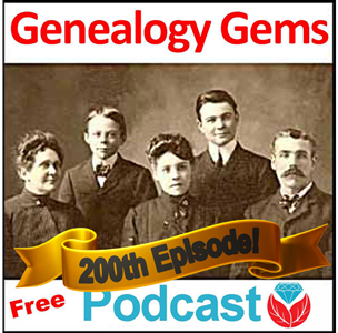
Episode 200
with Lisa Louise Cooke

Listen Now
It’s finally here – the 200th episode of the free Genealogy Gems podcast, also celebrating its 10th year.
In this special episode, Lisa invites Professor Mark Auslander to share his discoveries about a mother and young daughter separated by slavery. Learn how he pieced together their story from a poignant family heirloom found at a flea market.
Throughout the episode, you will hear from several listeners, past podcast guests, Gems staffers and supporters in the genealogy industry with congratulations, memories, stories, and favorite Gems tips. Listen for the DNA success story of an adoptee who never gave up his search for his biological roots.
Thanks to all listeners and friends who sent congratulations! Among them are:
Allison Dolan, Publisher, Family Tree Magazine. She mentioned the Family Tree Magazine Podcast
Bruce Buzbee, RootsMagic family history software
DearMYRTLE, veteran online genealogy educator and author of the award-winning DearMYRTLE blog. She mentioned Lisa’s Family History: Genealogy Made Easy podcast; her all-day seminars at societies; and classes at her booth during conferences.
Geoff Rasmussen, Legacy Family Tree webinars, and author of Kindred Voices: Listening for Our Ancestors
Jim Shaughnessy, Findmypast.com
Mary Tedesco, host and genealogist on PBS’ Genealogy Roadshow, founder of Origins Italy, co-author of Tracing Your Italian Ancestors and a guest on Genealogy Gems Podcast episode #175, talking about Italian research and her work on Genealogy Roadshow
Steve Luxenberg, author of Annie’s Ghosts: A Journey into a Family Secret. Listen to Lisa’s conversation with him in The Genealogy Gems Podcast episodes 120 and 121. This book and interview planted the seed for the Genealogy Gems Book Club!
Yev Pusin, Social Marketing Marketer, Backblaze online computer backup service, also celebrating its 10th anniversary
MAILBOX: LISA AND SUNNY
The following were mentioned in listener emails and voicemails:
Family History: Genealogy Made Easy Podcast by Lisa Louise Cooke. This is a FREE step-by-step series for beginning genealogists?and more experienced ones who want to brush up or learn something new. One listener mentioned the series on naturalization records in episodes 29-31.
The Genealogy Gems Premium Podcast by Lisa Louise Cooke. Monthly episodes?and the full archive of past episodes?are available to Genealogy Gems Premium website subscribers. This podcast takes what you love about the free Genealogy Gems podcast and goes deeper, broader and more exclusively into topics of interest for U.S. and international audiences.
The Genealogy Gems app is FREE in Google Play and is only $2.99 for Windows, iPhone and iPad users.

Using Evernote to organize your family history research: free tips and great resources to help you make the most of this free app (or its Premium version) to keep all your genealogy research notes and links organized and at your fingertips.
Netvibes computer dashboard tool and mobile apps for genealogy
Computer backup story from Kathy: “I was robbed! They took the computer AND the backup drive!”

Keep your family history research, photos, tree software files, videos and all other computer files safely backed up with Backblaze, the official cloud-based computer backup system for Lisa Louise Cooke’s Genealogy Gems. Learn more at http://www.backblaze.com/Lisa.
DNA WITH YOUR DNA GUIDE DIAHAN SOUTHARD
Diahan’s series of how-to videos, available to Gems fans for a special price.
Diahan’s series of DNA quick guides, available in print or as digital downloads

Lisa Louise Cooke uses and recommends RootsMagic family history software. From within RootsMagic, you can search WebHints on FamilySearch.org, Findmypast.com and MyHeritage.com. Soon RootsMagic will also be able to search records and even sync your tree with Ancestry.com, too.
MyHeritage.com is the place to make connections with relatives overseas, particularly with those who may still live in your buy medicine online worldwide ancestral homeland. Click here to see what MyHeritage can do for you: it’s free to get started.
INTERVIEW: MARK AUSLANDER

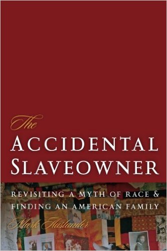
Mark Auslander is an Associate Professor and Museum Director at Central Washington University in Ellensburg, WA and the author of The Accidental Slaveowner: Revisiting a Myth of Race and Finding An American Family.
“Slave Mother’s Love in 56 Carefully-Stitched Words”
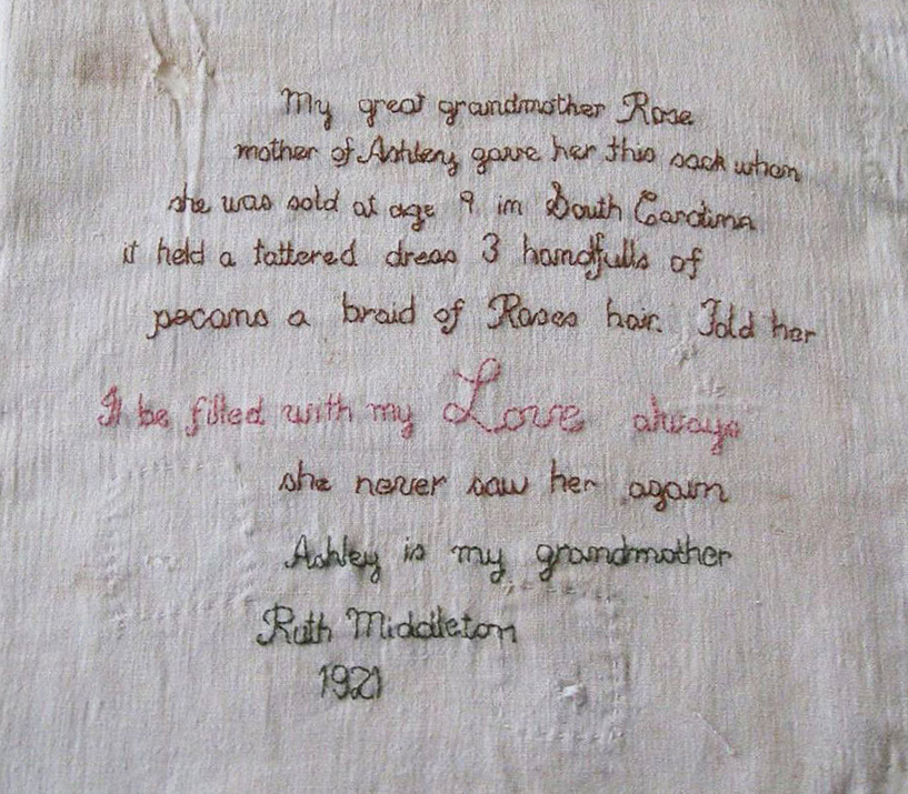
Mark’s path to the probable family of this artifact used these techniques:
Look closely at all clues from the artifact: the fabric, stitching, colors, facts conveyed in the text, etc. Look at both the historical clues and the artistic or symbolic aspects of it.
Create a profile for the people mentioned based on what is known. Probable age for Ruth Middleton in 1921, etc.
Use contextual and social history clues to hypothesize a scenario. The inclusion of “South Carolina” hints that the seamstress didn’t live in South Carolina, so he guessed that she was part of the Great Migration of millions of African-Americans in the early 1900s who headed from the rural South to the industrial Midwest and other urban cities.
Take advantage of unusual clues. Rose is a common name for an enslaved woman, but not Ashley.
Look through all available records. Possible census listings for Ruth Middleton in 1920 didn’t seem likely candidates. He dug through marriage records for Northern states until he found a woman named Ruth who married a man named Middleton who fit the profile he’d created.
Use specialized sources for African-American research, especially records created by and about the slaveholder that relate to the holding, sale or transfer of enslaved people.
Mark says that some researchers describe the search process as “guided by some force larger than yourself that keeps you going through those endless hours in microfilm rooms or online. But it does connect us all in very profound ways to those who came before and those who come after?.Through genealogical work, in a sense we can triumph over death itself and we can move back and forth in time in the most remarkable way.”
Coming up next month in The Genealogy Gems Podcast episode 201: An interview with Angela Walton-Raji on finding African-American ancestors. She shares tons of resources! Even if you haven’t found any African-Americans on your family tree, the challenges and rewards of African-American genealogical research are both fascinating and moving to learn about.

Legacy Tree Genealogists provides expert genealogy research service that works with your research goals, budget and schedule. The Legacy Tree Discovery package offers 3.5 hours of preliminary analysis and research recommendations: a great choice if you’ve hit a brick wall in your research and could use some expert guidance. GENEALOGY GEMS EXCLUSIVE OFFER: Go to www.legacytree.com/genealogygems and use coupon code GEMS100 to save $100 off your purchase of research services (expires 4/30/17).
CONVERSATIONS WITH MORE GEMS
Amie Tennant, Gems Content Contributor: see the Genealogy Gems blog
Lacey Cooke, Gems Service Manager
Vienna Thomas, Associate Producer and Audio Editor; she mentioned a favorite Genealogy Gems Book Club title and interview were with Chris Cleave, author of Everyone Brave is Forgiven
GENEALOGY GEMS BOOK CLUB


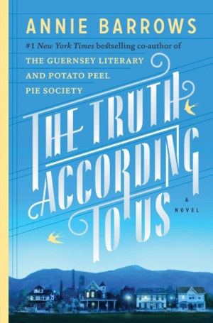
The Truth According to Us by internationally bestselling author Annie Barrows
It’s the summer of 1938, and wealthy young socialite Miss Layla Beck is now on the dole as a WPA worker, assigned to write a history of the small town of Macedonia, West Virginia. As she starts asking questions about the town’s past, she is drawn into the secrets of the family she’s staying with?and drawn to a certain handsome member of that family. She and two of those family members take turns narrating the story from different points of view, exploring the theme that historical truth, like beauty, is often in the eye of the beholder.
Click here to read an introduction to using WPA records for genealogy.
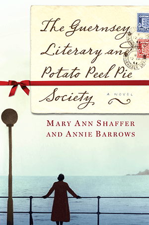
Annie Barrows is also the co-author of The Guernsey Literary and Potato Peel Pie Society. This novel takes place after World War II in a London recovering from the Blitz and an island recovering from German occupation. At the heart of Guernsey is an unlikely love story and the inspiring tale of a community that took care of each other in their darkest days with humor, compassion and good books.
Click here to see more Genealogy Gems Book Club selections and how you can listen to Lisa’s upcoming exclusive conversation with author Annie Barrows about The Truth According to Us.
Music from this episode is from the band Venice
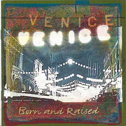

The song played at the opening was “We’re Still Here,” from the album Born and Raised.
The song played at the closing was “The Family Tree” from the album 2 Meter Sessies; click to purchase the album or download the song as a single.
FREE NEWSLETTER:
Subscribe to the Genealogy Gems newsletter to receive a free weekly e-mail newsletter, with tips, inspiration and money-saving deals.
Check out this new episode!
Disclosure: This article contains affiliate links and Genealogy Gems will be compensated if you make a purchase after clicking on these links (at no additional cost to you). Thank you for supporting Genealogy Gems!
by Lisa Cooke | Sep 30, 2017 | 01 What's New, Military, Records & databases, United States |
Do you have ALL your ancestors’ U.S. draft registration records–from the Civil War until after World War II? These documents may be filled with genealogy clues, whether your ancestor served in a war or not. Military expert Michael Strauss presents this roll call of U.S. draft registration records you’ll want to check!
Thanks to Michael L. Strauss of Genealogy Research Network for providing this guest post.
Military records can lead genealogists to many new sources of information. One of the first records that you may come across (for our United States ancestors) that could provide unknown information are found in draft registrations. The records are civilian in scope, but can provide clues of prior military service or proof of current war conditions.
The National Archives holds custody overall for the bulk of the draft registrations from the Civil War to post-war World War II. The Archives organizes their records by grouping numbers. The Civil War draft registrations are found in two record groups, RG59 and RG110. Later draft registrations are found in RG147. In all cases, finding aids are available to locate and obtain copies.
Civil War Draft Registration Records
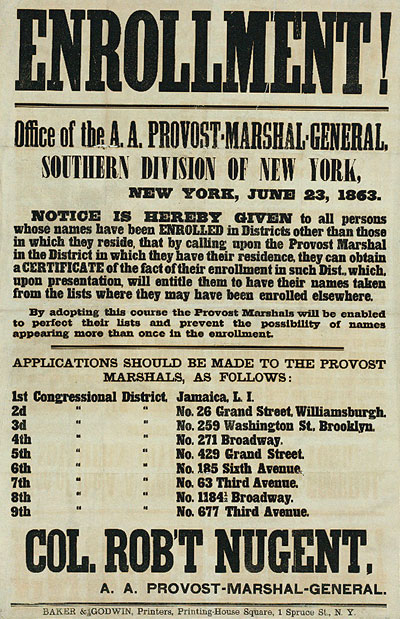
Recruiting poster, New York printed by Baker & Godwin, June 23, 1863. Public domain image hosted at Wikipedia.org (click to view).
Civil War draft records date back to the first national draft which was signed by Abraham Lincoln on March 3, 1863. This draft only applied to men residing in states under Union control. The draft includes several lists detailing information about men eligible to be drafted to fight for the Federal Army. This included consolidated lists for men between the ages of 20-45, which are grouped and divided into two classes of records. This list contains the name, residence, age, race, marital status, place of birth, any former military service, occupation, and remarks for each registrant. (Remarks might include ineligibility based on religious reasons or former service in the Confederate Army.)
Other registrations included medical exams, statements of substitutes, and case files of persons who were draft aliens. (Aliens were ineligible for military service and therefore contain files that document their nativity.) All of these are at the National Archives.
The last group of records includes the descriptive rolls that contain the name, age, physical descriptions, where born, occupation, when and where drafted, and remarks. The descriptive books are located at the regional branches of the National Archives and can be accessed by researchers, as these have not been filmed or scanned. Records are divided into two separate record groups: RG59 (Department of State) covered those men who were aliens and RG110 (Provost Marshal) has all the other lists of men being drafted.
The only Civil War draft registration records available online are the consolidated lists; click here to search them at Ancestry.com (subscription required). On the Confederate side, there are a limited number of draft records available, some at the National Archive and some in the custody of individual state archives.
World War I Draft Registration Records
For a number of years, there was no draft or draft registration. However, when the United States entered the war in Europe on April 6, 1917, the country was totally unprepared for overseas campaigning. This conflict forced our government to consider other means to recruit the tens of thousands of men it would take to wage this war. The Selective Service Act of 1917 authorized the President of the United States to increase the military establishment being passed by Congress on May 18, 1917. The Act directed the Provost Marshal General Office (P.M.G.O.) to select men eligible for military service.
All men were required to register, native-born or aliens. The draft is separated into three registrations:
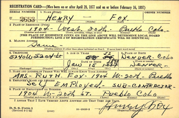
- The 1st draft registration was dated June 5, 1917 for men aged 21 to 31 and consisted of 12 questions.
- The 2nd draft registration was dated June 5, 1918 for men who had turned 21 since the previous registration and included a supplemental registration on August 24, 1918 for men turning 21 after June 5, 1918. Each consisted of 10 questions.
- The 3rd draft registration was dated September 12, 1918 and was intended for all men aged 18 to 45 years. It consisted of 20 questions.
Each registrant was required to provide their name, age, birth date, and birthplace (in 2 of the 3 registrations), occupation or employer, nearest family, and a summarized physical description.

WWI draft registration of Henry Fox. Image from Ancestry.com.
By the end of World War I, nearly 24 million men had registered for the draft (this number excluded registered enemy aliens and those already in the military). The original draft cards are at the National Archives branch in Morrow, Georgia. World War I draft registrations are available online at Ancestry.com, FamilySearch.org, Findmypast.com and fold3. FamilySearch is the only one with free access (a personal subscription or library access is required for the others).
World War II Draft Registration Records
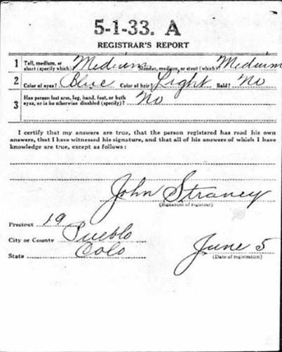
The eve of World War II saw the passage of another conscription act. This act was the Selective Training and Service Act of 1940, and was the first peace time conscription in United States History. This act officially established the Selective Service System. The draft during World War II consisted of seven registrations. The “Old Man’s Draft,” or 4th registration, was for men born between 1877 and 1897, with the other six registrations intended for the younger adult men born after 1897:
- 1st: October 16, 1940, included all men 21-31.
- 2nd: July 1, 1941, for those men who reached age 21 since the first registration.
- 3rd: February 16, 1942, for men ages 20-21 and ages 35-44.
- 4th: April 27, 1942, for all men between the ages of 45 and 64. The registrants were not eligible for military service (this is the “Old Man’s Draft”).
- 5th: June 30, 1942, for all men between the ages of 18 and 20.
- 6th: December 10 – 31, 1942, for all men who had reached the age of 18 since the previous registration.
- 7th: November 16 – December 31, 1943, for American men living abroad between the ages of 18 and 44.
Registrants were required to provide their name, address, birth date, birthplace, and employer’s information, along with a contact individual who would always know the registrant’s information or address. The form also asked for the telephone number of the registrant in addition to a more complete physical description.
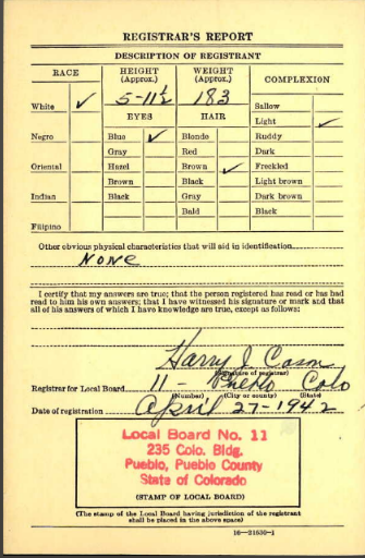
WWII draft registration of Henry Fox. Image from Ancestry.com.
Several of the states that recorded the “Old Man’s Draft” were lost. The National Archives no longer has these records available. These states include: AL, FL, GA, KY, MS, NC, SC, and TN.
Not all of the World War II Draft registrations are available online. Less the states above, view 4th registrations online at Ancestry.com, Familysearch.org (index and browse-only images) and fold3. The fold3 database includes 25 states and territories: AL, AK, AR, AR, CO, CT, DE, FL, GA, HA, ID, LA, MD, NV, NM, NC, OK, PA, UT, VA, WV, WY, and the District of Columbia and the Virgin Islands. (On Ancestry.com, the number of states is limited to AR, GA, LA, and NC.) Other states are in the process of being added. However, the remaining states are only available directly from the National Archives in St. Louis, MO.
Some of the other registrations are also available online for a selected grouping of states.
Expert tip: It is not uncommon to find men registered for both World War I and World War II draft registrations, which would depend on their ages.
Post-World War II Draft Registration Records
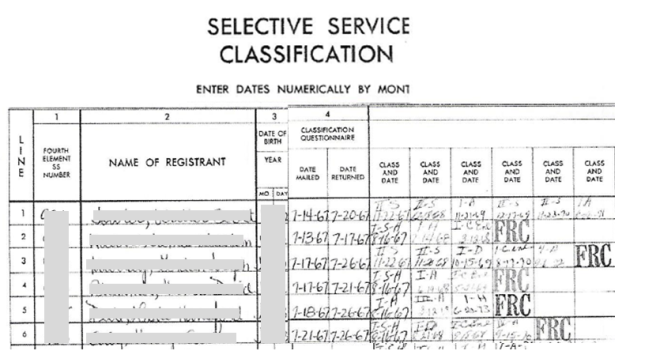
The draft and registrations didn’t cease with the conclusion of World War II. It was active from 1948 until 1973, when President Richard M. Nixon officially signed legislation that ended the draft. This was suspended in 1975, and five years later, in 1980, President James E. Carter again brought back into activity the Selective Service System. This came in response to the Soviet invasion of Afghanistan. To date, the Selective Service System still remains active, requiring all men to register within 30 days of their reaching the age of 18 years.
To gain access those records not online from World War II, and for the later registration cards for men for the Korean and Vietnam conflicts and for other years, researchers will need to contact the National Archives in St. Louis, MO. This office handles the original cards for all men born between April 28, 1877 and March 28, 1957. The National Archives fee schedule is in place to request the records by mail. A copy of the Draft Registration Card (SSS Form 1) alone costs $7.00, or order a copy of it along with the Draft Classification History (SSS Form 102) for $27.00. Click here to go to the National Archives’ webpage for ordering Selective Service records.
Draft Registration Records for Men Born after 1960
The law never required men to register who were born between March 29, 1957 and December 31, 1959. The National Archives doesn’t hold copies of records for men born after January 1, 1960. To gain access to draft registration for all other years, contact the Selective Service System directly. Click here for all the details.
 Michael L. Strauss contributes the new Military Minutes segment on the Genealogy Gems Podcast. Listen to this segment in the free Genealogy Gems Podcast episode 207.
Disclosure: This article contains affiliate links and Genealogy Gems will be compensated if you make a purchase after clicking on these links (at no additional cost to you). Thank you for supporting Genealogy Gems!