Google Drive is giving some of their competitors a run for their money. This free google tool is just what genealogists are looking for to create, consolidate, and organize their files.
I have been using Google Drive for about a year now. I upload my family photos, GEDCOMs, and my family history notes to the drive. I love the ease in which I can save these things to the cloud and rest knowing my hard work is safely backed up. You can imagine my excitement when our Google expert, Lisa Louise Cooke, shared her new premium video: All About Google Drive. There is so much more I didn’t know Google Drive could do!
Lisa shares ten benefits to using Google Drive and how it packs a powerful punch. Used as a file hosting service, Google Drive can offer you more free storage than Dropbox. Further, Google Drive may be a viable competitor to Evernote for several reasons. You can store files, create files, and edit them all via Google Drive. What’s even better is that Google Drive works across all different computing devices like PC, Mac, Windows, Android, and Apple. This means that syncing and accessing it all has never been easier.
Getting More from Google Drive
But wait, there’s more! Just when you thought you have heard it all, Lisa shares the power of the companion tool, Google Docs, to create documents, drawings, forms, and more. Haven’t had the money to purchase Microsoft Office yet? Not a problem! Google Docs is free to use. Lisa walks you through how to create and save a document and other files by using Google Docs. It is so easy!
You will continue to be amazed at the Google Extensions that are available from the Google Store. I had no idea there were so many. I was particularly excited to hear how I could easily save and clip items from webpages. Imagine finding a digital image of your great-grandmother’s obituary you want to save. How do you do that without having to save the whole page? There’s a Google Extension for that!
Google Drive, Google Docs, and the many extensions available really pack a powerful punch. Watch All About Google Drive to learn more about these knock-out features!
The Genealogy Gems Premium website members have exclusive access to all our full length video tutorials on topics ranging from research strategies to technology tools. They also have access to the full audio archive of The Genealogy Gems Premium Podcast. Click here to learn more about The Genealogy Gems Premium Membership.
Pieces of your family history are on video on YouTube, and in this episode I’m showing you how to find them! Here’s what you’re going to learn:
Why you can almost be sure that there are videos on YouTube pertaining to your family’s history.
The best strategies for finding videos about your family history.
7 things to do when you find a video about some part of your family history.
How to find family history related videos on YouTube
Can you really find family history related videos on YouTube? You bet you can! Thanks to the tremendous growth in online video, your chances are better than ever. Here’s how much online video has grown in recent years:
YouTube is now the second most popular search engine next to Google.com.
Cisco reports: 2014 64% of all Internet traffic was video. The prediction for 2021 is 85%.
More than 1 billion unique users visit YouTube each month to watch and upload video.
Digitizing video is easier and more affordable than ever.
So, what kind of videos can be found that have to do with your family history? Here are just a few examples:
Old home movies. Perhaps uploaded by a close or distance family member, or a friend of the family who happened to capture your family in their home movies.
Vintage news reels and TV news broadcasts.
Your family members don’t have to be famous to show up in local news reports.
Corporate videos.
Companies often create instructional and promotional films.
Video tours. Filmed at historical locations, churches, and other places where your ancestors may have lived.
Historical documentaries.
These can provide great background information about the times and places where your ancestors lived.
How to start finding family history videos on YouTube
The easiest way to get started is by selecting a person in your family tree. If you’re looking for actual film footage of the person, you’ll want to focus on more recent people in your family. However, there’s a treasure trove of videos available on YouTube so don’t worry if you’re trying to learn more about an ancestor born in 1800. You can still find all kinds of videos that can shed more life on your ancestor’s world and the life they may have led.
Once you’ve selected an ancestor, make a list of things you know about them. Here are some examples of what you could look for:
Names of associate ancestors
Places where they lived
Where they went to school
Where they worked
Events they were involved in
Hobbies / Groups / Clubs
Friends / Associates
etc.
Search your ancestor’s name at YouTube
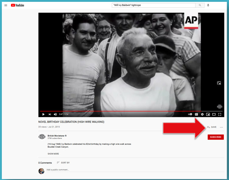
Start by searching for your ancestor’s name in the search field at YouTube. Example search: Will Ivy Baldwin
Review the results. Keep an eye out for film footage that looks older. Hover your mouse over the results to see if words appear that further explain why you received that video as result. You may see an indication that what you searched for appears in the text of the video description (found just below the video) or the captions. If they appear in the captions, that means that someone in the video said the name you searched for! Automated closed captions are fairly new so you will find that not all videos have captions.
Next add more keywords relevant to their life. Example: Will Ivy Baldwin tightrope
Use quotation marks to get exact matches on the important words. Example: Will Ivy “Baldwin” “tightrope”. (Learn more about search operators such as quotation marks in my book The Genealogist’s Google Toolbox.)
Try variations and search multiple times. Examples:
Will Ivy “Baldwin” “tightrope”
Will “Ivy Baldwin” “tightrope”
“Will Ivy Baldwin” “tightrope”
Will Ivy “Baldwin” “Colorado”
You can also search for the phrase Home Movie and a family surname. Example search: “Home movie” “Burkett”
What to do when you find a family history video on YouTube
#1 Add to your “Watch Later” YouTube playlist.
Click the plus sign under the video and check the box for Watch Later.”
#2 Create a new playlist and add the video.
Click the plus sign and then Create New Playlist. Consider creating a playlist for each surname you research.
Click the plus sign to save to your Watch List or create a new genealogy playlist.
#3 Share to Social Media, your website, etc.
Click Share under the video.
#4 Comment to collaborate.
Comments can be found below the video description. You’ll need to be signed into YouTube with a free Google account.
#5 Subscribe to get new uploaded videos.
The red SUBSCRIBE button can be found on every video and channel. After clicking it, click the bell icon to receive notifications of new videos from that channel.
#6 Search the YouTube Channel for more related videos.
There’s a good chance if the channel has one relevant video it will have another! Click the name of the channel below the video and then on the channel page click the magnifying glass search icon.
#7 Read the video description to learn more.
The channel “Creator” who uploaded the video probably added some additional information to the video description. Click SHOW MORE to see everything. Look for recommended related videos and playlists. You may also see more details on the content of the video which you can then use to expand your search.
Expanding Your Search to Find More Family History Videos
Now it’s time to dig back into our list and continue the search. Here are some examples of how to find videos.
Search for Ancestral Locations
Search for locations associate with your family history such as cities, counties, regions, states, countries. Even if your ancestors is not in the video, it could be very enlightening to see film footage from a place they talked about or wrote about. Watching a video about the place can help bring your family history to life.
Review old newspapers, journals, family interviews and more to come up with a list of events your family was involved with. It doesn’t have to be a big event. It could be as simple as a school talent show. It’s possible that someone else who attended took home movies.
Try search for the names of business where your ancestors worked. Add in locations such as town names. Try adding the word history to help YouTube find older film footage.
In this episode of Elevenses with Lisa I shared the example of searching for Olyphant PA fire history and finding Andrew O’Hotnicky and his son in an old newsreel film about the fire stations amazing dog.
Andrew O’Hotnicky on film on YouTube.
Post Your Own Family History Videos Online
Another great way to find old videos and home movies on YouTube is to upload your own. That may sound funny at first, but the truth is that if you’re looking for family history other people are too. When you upload a video, whether it’s an old home movie or a short video you made to tell the story of one of your ancestors, it’s great “cousin bait.” When someone else searches for the same family, your video will appear. This opens the door to them posting a comment and potentially sharing information.
If you don’t have old home movies to post, don’t worry. It’s easier and more affordable than ever to make your own videos. I’ve created several instructional videos to help you create exactly the kind of video you want Both are available exclusively for Genealogy Gems Premium Members (Learn more here about becoming a Premium Member):
Video Magic – a 3-part video series that walk you through crafting your story and getting it on video.
Elevenses with Lisa episode 16 How to Make a Family History Video with Adobe Spark walks you step-by-step through how to use a free app to make professionally looking videos.
Recording your own videos is faster, easier and less expensive than ever! You can have your own free YouTube channel with your free Google Account.
Resources
Get the book: The Genealogist’s Google Toolbox, 3rd ed., by Lisa Louise Cooke. Available exclusively at www.shopgenealogygems.com.
This genealogy researcher searched for home movies on YouTube after hearing Lisa Louise Cooke talk about the kinds of footage you can find for your family history. Check out this eye-popping discovery of a video showing her daredevil great-uncle in action…at age...
Making your family history accessible to your visually or hearing impaired relatives may require a little extra work. But the effort can mean making your genealogy discoveries more available and vivid for EVERYONE–now and in the future. Let these ideas help you!...
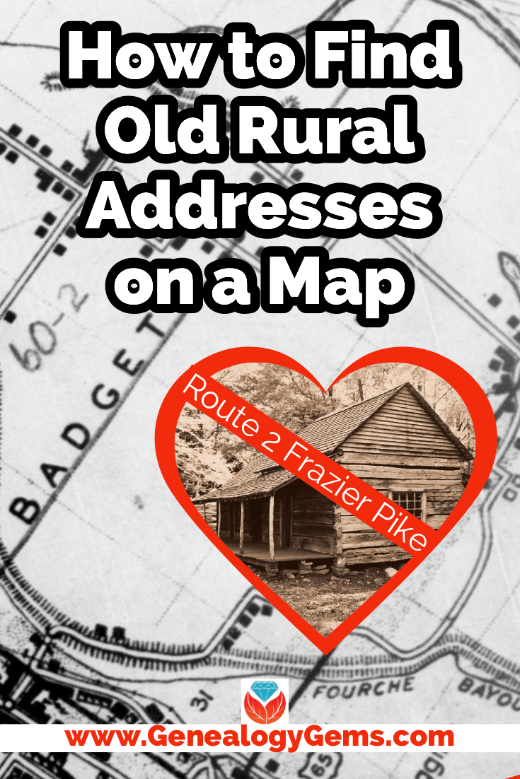
Have you ever found an address for an ancestor but been disappointed that it is just a Route number and a town name? Have you wondered if it is possible to figure out where they actually lived? The good news is, it is! I’m going to show you how to take a rural “route” address from the early 20th century and find it on an old census enumeration district map.
(This article contains affiliate links for which we may be compensated. Thank you for supporting our free content.)
In a recent video I showed you how to find 1950 Census Enumeration District (ED) maps. These are super helpful and also free. In that video we used the address of an ancestor that we found by hunting through old letters and documents. But for many Americans in the early 20th century that address may have just been a route number and town.
That was the case for my viewer Lisa. She emailed me after she watched the video. She writes, “How can you find the E.D. number when you only have a Route number? My relatives lived in rural Arkansas.”
This is totally doable! Follow allow these steps of this case study and they will help you find the E.D. number and census enumeration district maps, and zero in on the location.
“Route 2” & Rural Delivery
A carrier route is basically the territory one letter carrier can cover on a daily basis. So, there could be a Route 1 or a Route 2 in thousands of places around the country. It just happens that your ancestor was on, say, Route 2 in a particular township area. Although it doesn’t tell us which house, it does dramatically narrow down the place because a daily route was the same and may not have been that large. Once we find that area we can then use other sources to help us try to get even more specific.
The first thing we need to do is gather some details. We need:
The ancestors’ names
The Route number address which includes the town
The county – which is something we can easily find online with a quick search
The year – in this case the address she has is from 1950.
So, here’s what Lisa sent me about her ancestors, the Blazers:
Names: Joseph Madison Blazer and Minnie Blazer
Route number: Route 2
Address: Frazier Pike
County: Pulaski
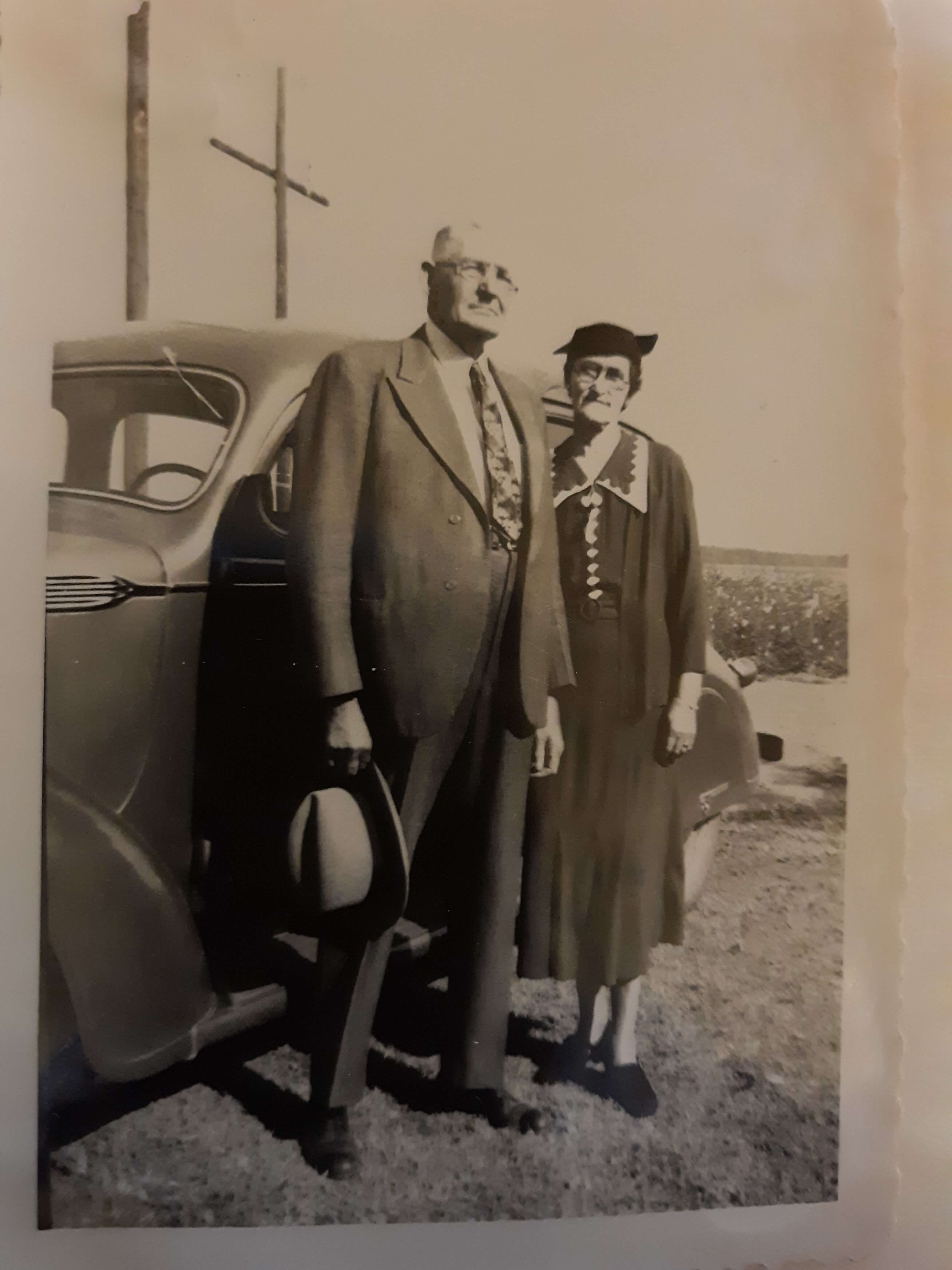
Joe and Minnie Blazer c1950 (Image courtesy of Lisa Egner.)
Step 2: Find the Family in the Census
Now we need to find the family in the census record closest to the date of the known address.
Since the 1950 census hasn’t been released yet because I’m recording this in Jan. of 2022, we can’t yet pull up their record. So, we’ll need to turn to the 1940 census. There’s a good chance that the family was in the same location since folks didn’t typically move around quite as much or as far as we do these days.
The 1940 census is available for free at many of the larger genealogy websites like FamilySearch and Ancestry.
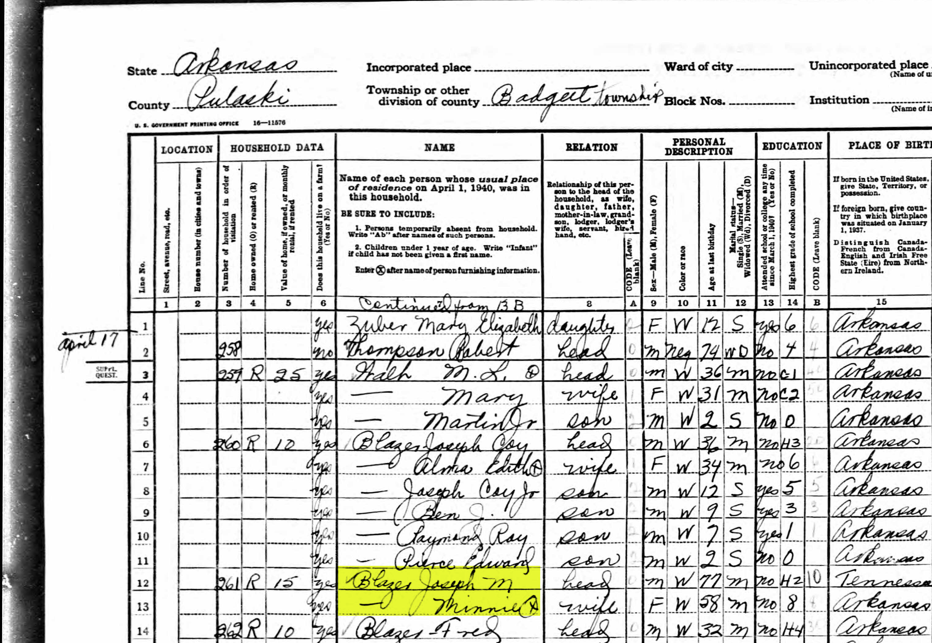
Here’s the Blazer family in the 1940 census, and Lisa confirmed that she believes this is the same place.
On the census record we are looking for three very important things:
the township (Badgett Township)
the ED number (60-2B)
and any address written along the left margin. If you don’t see anything, check the pages before and after that page. (Frazier Pike)
Step 3: Search for the Township
Once you have the location or township, search for them in an online map. I prefer to use Google Earth, but I often also use Google Maps. It doesn’t hurt to check both.
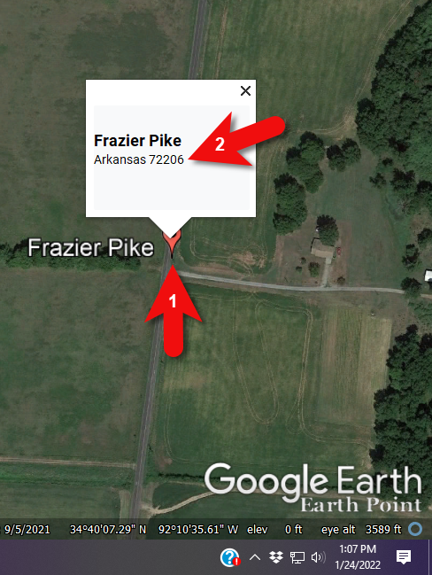
In this case we have two locations to look for: Badgett Township and Frazier Pike. We’ll start with the actual address which was Frazier Pike, Arkansas. Google Earth tell us that it’s a road just southeast of Little Rock, AR. When you click the pin it also tells you the current zip code for the Frazier Pike area, so we’ll make note of that. I’m like to create a project folder (Blazer Address) in my Places panel and then save the location pin in it. I will add additional items to the folder as I find them.
Click the pin to see the zip code.
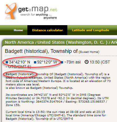
Next, I’ll search for the other location found in the 1940 census, Badgett Township. It doesn’t appear in either Google Earth or Google Maps. That’s probably because it’s been renamed or incorporated. Googling may be able to help so I googled: badgett township arkansas history.
This led me to a website that provided several helpful clues. It says that Badgett is “historical”, meaning that it’s the old name of the town which has since changed. It also provides us with the latitude and longitude of Badgett which we can use in Google Earth to confirm it’s location.
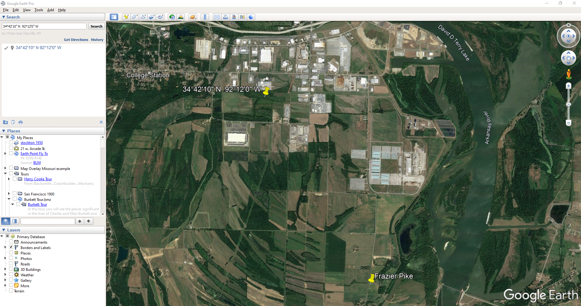
Go back to Google Earth and enter the coordinates (34°42’10” N 92°12’0″ W) in the search box and press ENTER on your keyboard.
The locations are very close.
And indeed, it’s very close to Frazier Pike. (image above)
I also like to look at the image results when googling. The website results are organized by the most relevant images. When I ran a search on Badgett, AR, and click Images on the results page, I see that the first one showed a map showing Frazier Pike. So, they are nearly one and the same.
Another search result was theHome Town Locator website. It says “the Township of Badgett (historical) is a cultural feature (civil) in Pulaski County. The primary coordinates for Township of Badgett (historical) places it within the AR 72206 ZIP Code delivery area.” This confirms that it is historical, the coordinates pin the same place on the map, and the current zip code is the same.
A quick Find on the page search (Alt + F) for Route 2 jumps me to a nice bit of history.
In the section discussing schoolhouses we get a description of the route: “…located in the main red-dirt road called Route 2 in Pulaski County. Route 2 is now known as Frazier Pike.”
Step 4: Find the ED Map for the Closest Census
Next, we turn our attention to the enumeration district or ED number we found on the 1940 census. As you’ll recall, 1940 is the closest available census record to the date of the address, and we found Lisa’s ancestors in that record in Badgett, AR which we now know is the Frazier Pike area in Pulaski county. On that record it says: Badgett Township. ED 60-2B.
We could google for the year of the census and the words enumeration district map. However, there’s a great free tool for finding them over at Steve Morse’s One-Step Tools website at stevemorse.org.
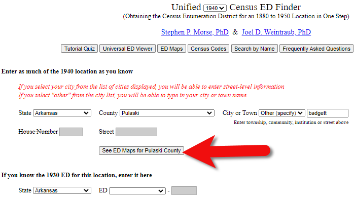
In the menu under U.S. Census select the Unified 1880-1950 Census ED Finder, select the year at the top of the page. In this case we will select 1940. Next, enter the state (Arkansas) and county (Pulaski). You can then select the city or town. However, in the case of rural addresses, don’t expect to find the town listed. If it offers you an “Other” option you can try and type the name of the town (Badgett) in the field provided. Don’t bother entering the route number (Route 2) because that’s not a street address, it’s a postal delivery address.
We could also run this same search on the 1950 census. Chances are you will see more ED numbers listed because the population was growing. Since an enumeration district had to be the size that one enumerator could cover in about a two week timeframe, they were often redivided as they decades went by.
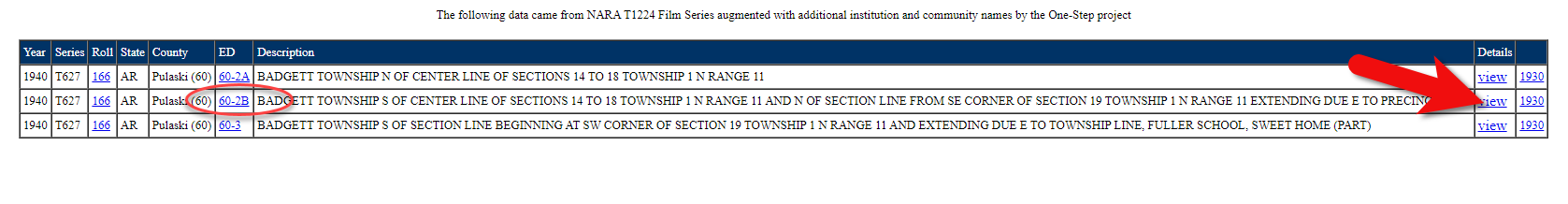
Since we know from the 1940 census that township was in existence, we should receive a list of ED numbers as a result. In this case we got three: 60-2A, 60-2B. and 60-3.
Click the corresponding ED number.
Click the linked ED number that matches the one you found in the census record. In this case, the 1940 census record told us that the Blazer family was in ED 60-2B, so we click that link.
The next page lists each ED. Click the View link for the ED.
Click the View link.
The View link will take you to the exact page for that ED in the ED Descriptions from the National Archives T1224 microfilm from Record Group 29. This description helps even further define the area.
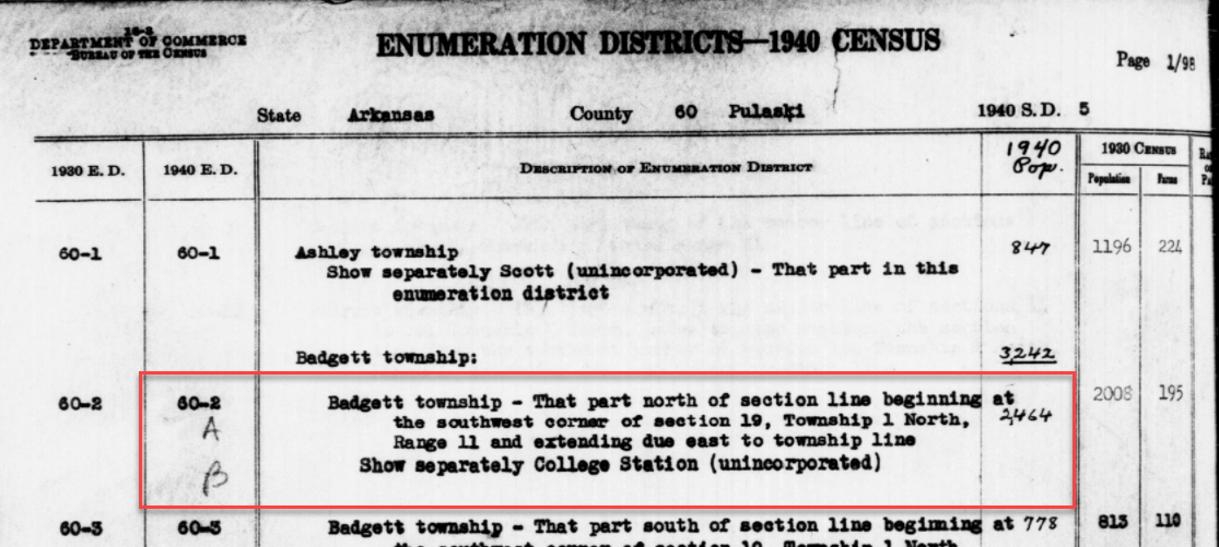
1940 Census ED Description
60-2 A and B says, “Badgett Township – That part north of section line beginning at the southwest corner of section 19, Township 1 North, Range 11 and extending due east to township line. Show separately College Station (unincorporated.)”
This is perfect because its’ giving us the township, range and section! We can use this information to plot it in Google Earth.
How to plot a land description in Google Earth with Earthpoint:
Enter the state, principal meridian (in this case there’s only one choice here thankfully), township, range and section numbers from the census description.
Click the Fly to on Google Earth button.
This may open automatically in Google Earth or you may be prompted to save the file to your computer. Do that and then click it to open. It is a KMZ file so it will automatically open in Google Earth.
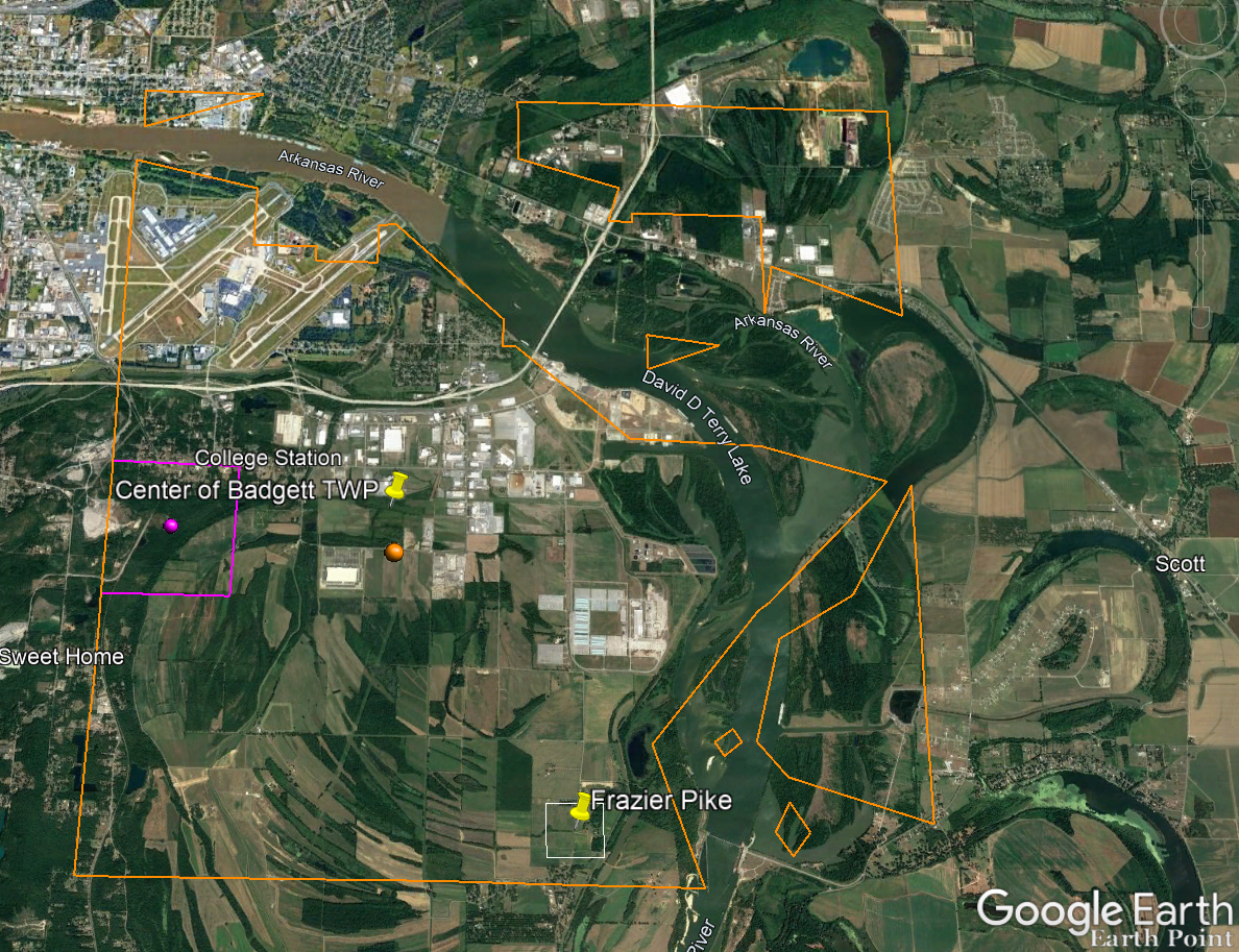
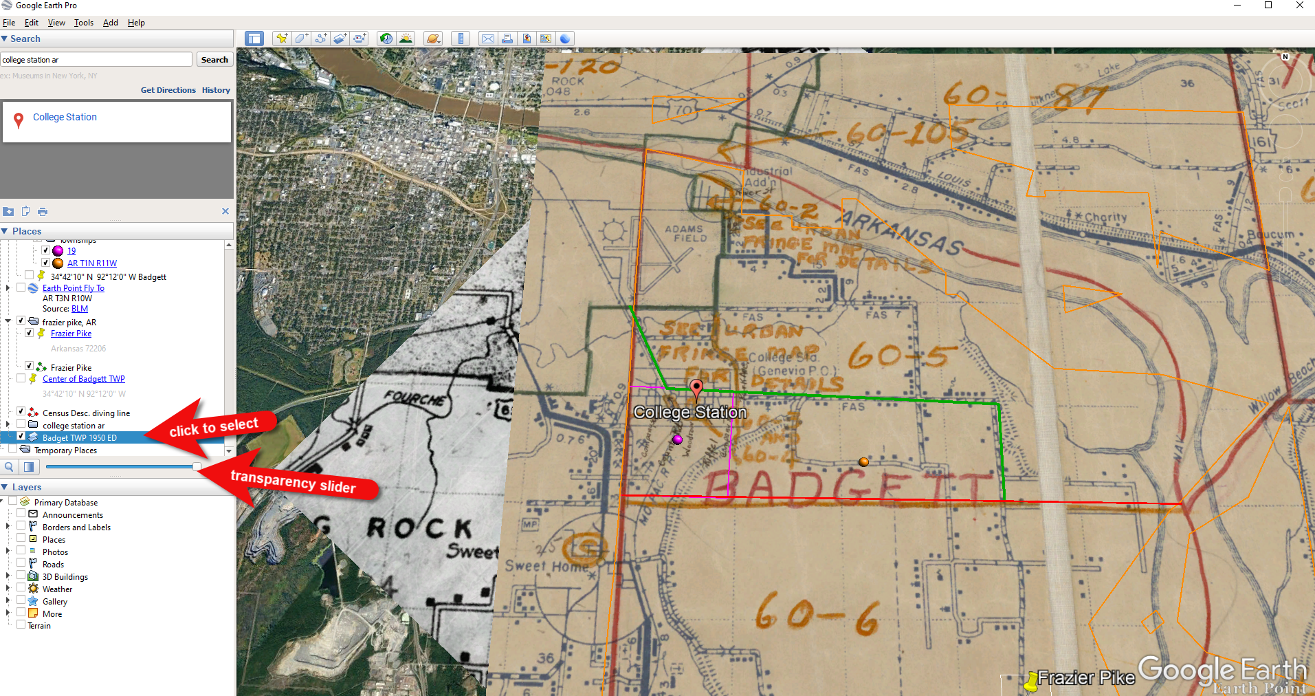
And here are the results! The location is mapped out for you.
Census description mapped in Google Earth.
Notice I still have my placemark pins for the approximate location of Frazier Pike, and the center of Badgett Twp which we got using the latitude and longitude coordinates. Section 19 is outlined in purple, and the township is outlined in orange.
Since Frazier Pike is a road, turn on Roads in the Layers panel. Now we can see that Frazier Pike is running north and south and our pin is right on top of it.
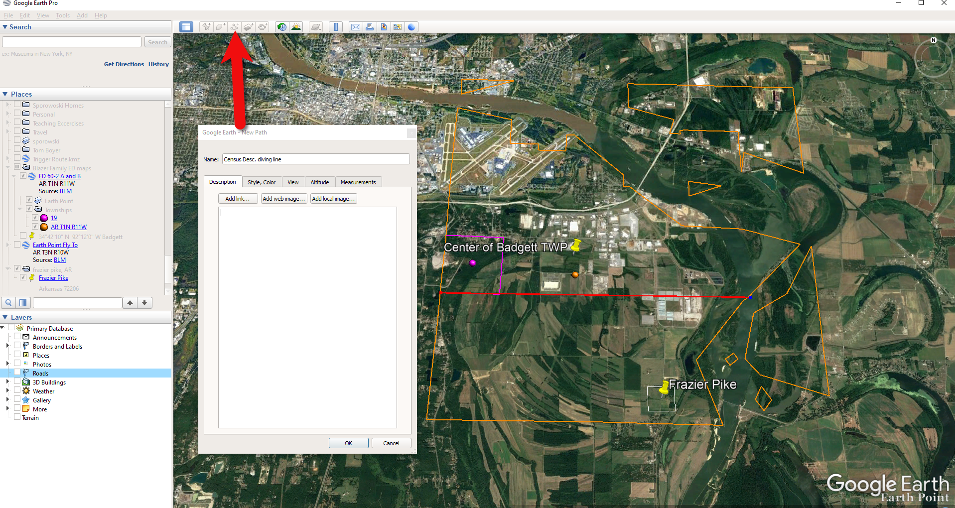
Now we can use the census description to further zero in on the area. “Badgett Township – That part north of section line beginning at the southwest corner of section 19 Township 1 North, Range 11 and extending due east to township line. Show separately College Station (unincorporated.)”
Mark that in Google Earth using the Path tool. Click the Path button in the toolbar at the top oof Google Earth. Click on the southwest corner of section 19 (outlined in purple) and then go east and click the township line (in orange.) Give your path a title and click OK.
Click the Path button in the tool bar.
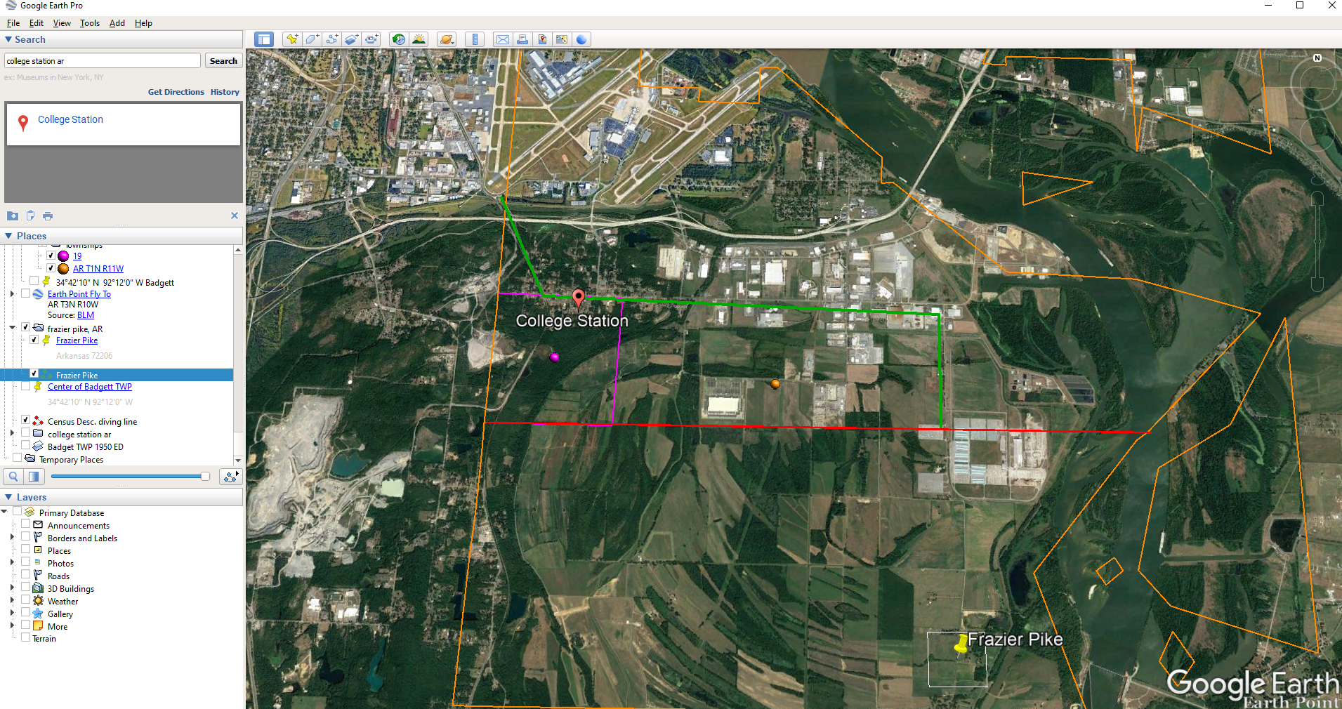
Next in the census description, on the same line as “B” it says “Show separately College Station (unincorporated.)” We can find College Park by searching for College Station, AR in the Google Earth search box.
Next, we want to follow Frazier Pike going north until we are above the section line that started in the southwest corner of Section 19. Use the Path tool again to mark it on the map.
Use the path tool to draw lines in Google Earth.
Get the Enumeration District Map
Now it’s time to head back to Steve Morse’s website and get the ED map for 1940. On the page you started your search, click the See ED Maps for… button.
Click the See ED Maps button.
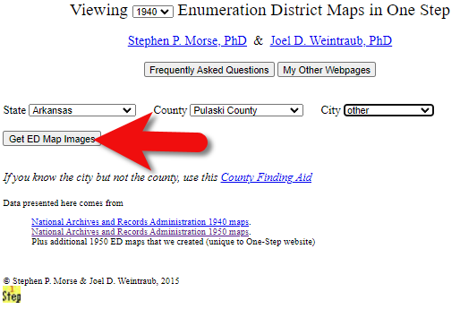
On the next page select the state, county and city again and click the Get ED Map Images button.
Click the Get ED Map Images button.
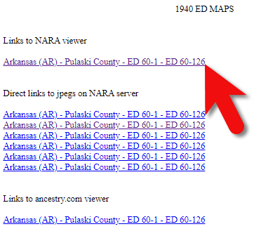
This will take you to a list of all of the available maps. The first link will take you to the National Archives webpage where you can look through all the maps for the area you selected. You could also look through all the individual maps by clicking each of the links listed under “Direct links to jpegs on NARA server”. However, I don’t recommend that will take longer because they are extremely large image files. It’s easier to quickly look through them on the NARA website.
Click the Link to NARA viewer.
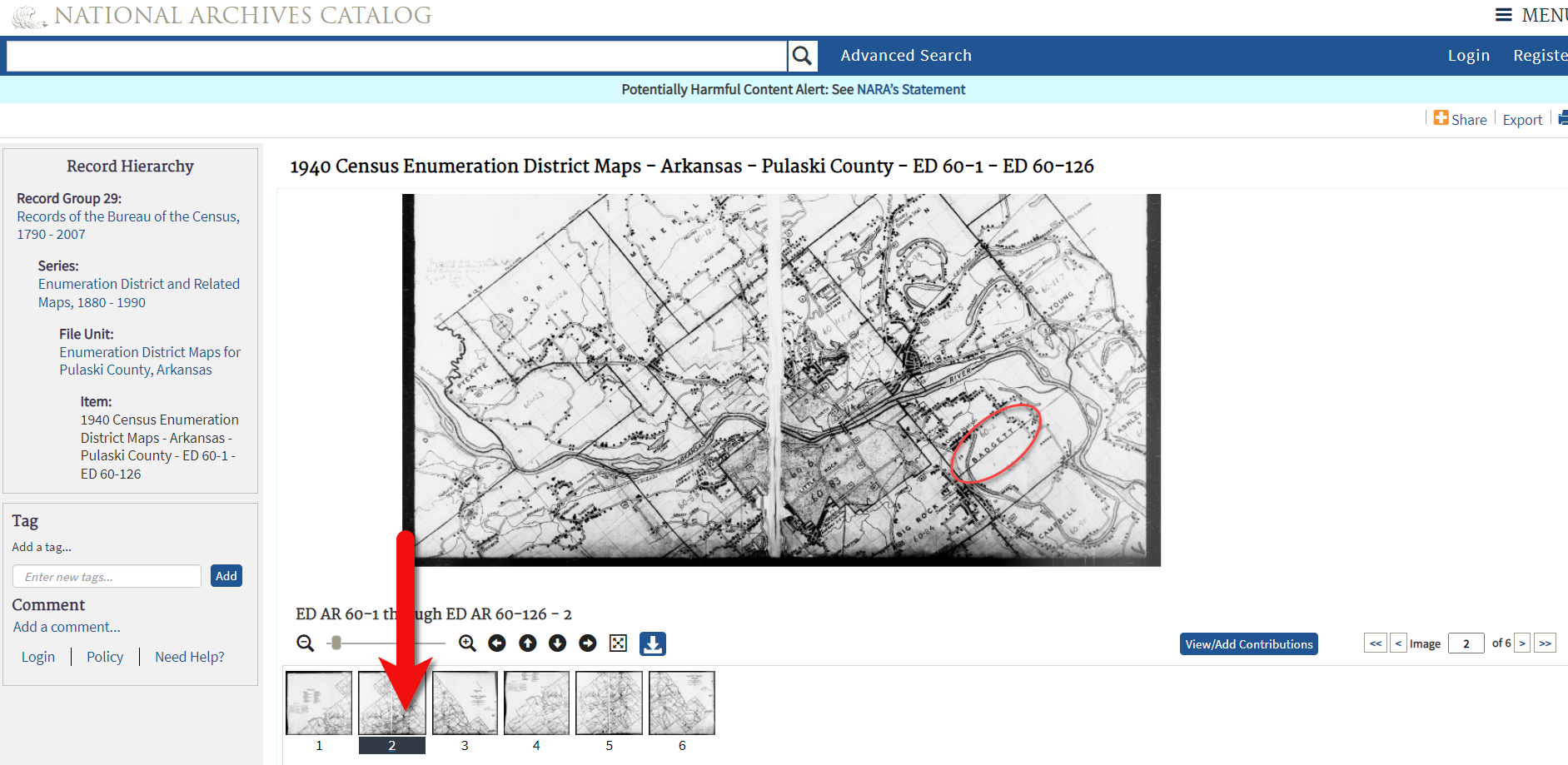
Click the link to the NARA viewer and look for the township name in the map thumbnail images. In this case I’m looking for Badgett. You can do this quickly by clicking each image and then drag the larger map in the viewer around with your mouse. I found Badgett Township in the second map.
Map images at NARA.
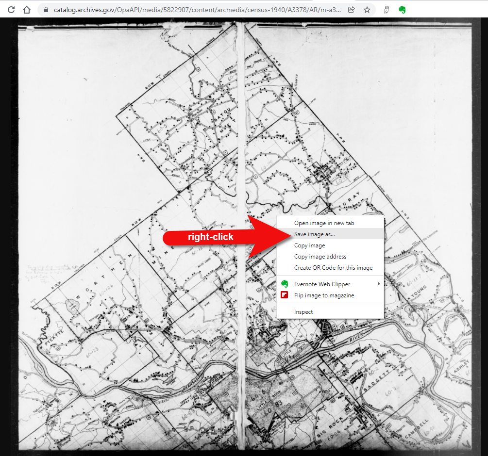
Download the full-sized map by selecting the thumbnail image and then clicking the download button (down arrow.) The full resolution map will load in your web browser. Right-click on it and Save Image As to save it to your computer.
Right-click on the map to save it to your computer.
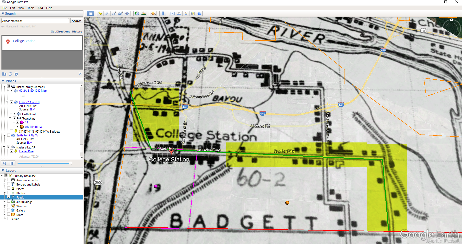
It can help to create a map overlay in Google Earth using this map. (Learn how to do this in the newest edition of my book The Genealogist’s Google Toolbox.) I cropped the image to just include Badgett Twp.
In fact, you can overlay both the 1940 and 1950 ED maps. Click to select a map in the Places panel and then you can use the transparency slide to fade it to reveal changes.
Select the map and use the opacity slider in Google Earth.
Step 5: Follow the Census
The census can provide even more clues about where in an enumeration district an address was located. Using the census record and the census description of the enumeration district, it can help to highlight the area of the map. In this case, ED 60-2 is “that part north of section line” which I marked with a red path line. The Blazers address was Frazier Pike (which I marked with a green line), so this eliminated the northern area and the Fourche Dam Pike road. To make sure that I could eliminate that area, I verified in the 1940 census that Fourche Dam Pike was enumerated separately by running a keyword search of the Pulaski County census records at Ancestry. And yes, indeed folks living along Fourche Dam Pike were enumerated separately and the road was written along the margin just as Frazier Pike was. This gives me a lot of confidence that I’m identifying the right area.
The route highlighted on the census ED map.
As you can see, there are little black squares and other markings on the map. To find out what each of those means we can turn back to the National Archives and download the page from this map collection that includes the map key.
The black squares are “Farm Units”. A farm unit square is not one family , it is the entire farm, including the owner and other families who may live and work on the farm. We also see businesses, churches, the town hall, school houses and more. We may not be able to find the exact home, but it’s possible to get very close. To do that, we need to head back to the census records themselves.
On Ancestry.com , the Blazers appear on Image 27. The filmstrip makes it easy to quickly scan through the images and browse them.
In this case, there are about 33 images or pages in ED 60-2B. The enumerator would start at one end of Frazier Pike and then make her way to the other. The enumerator wrote “College Station Pike” on pages 1 and 2. That isn’t a road today, and I couldn’t find any references to with a quick search. However, all of the other pages say, “Frazier Pike”. My guess would be that the census taker started on the west side – the hub of College Pike – and made her way east. Census enumerators visited homes and farms in a logical path, although they may have criss-crossed back and forth across the road. They listed the order in which they visited on the census form itself. In cities we might also see house numbers listed, but that’s not the case in a rural area. However, you may see pencil dots with visitation numbers written on the ED map. They were instructed to do this in rural areas in the census enumerator instructions in 1940. Unfortunately, the person enumerating 60-2B did not.
We could also look at the types of businesses and buildings shown on the map, and then look through the census records at occupations. We see a “factory/industrial” building to the east so we would look for people working in that environment in the census and see where they are living. We see a denser population in College Station along with a schoolhouse and two churches, so it would be worth looking through the census pages to see where the school teacher and pastors are listed. Folks may not have lived on the premises, but it would make sense they lived near their work.
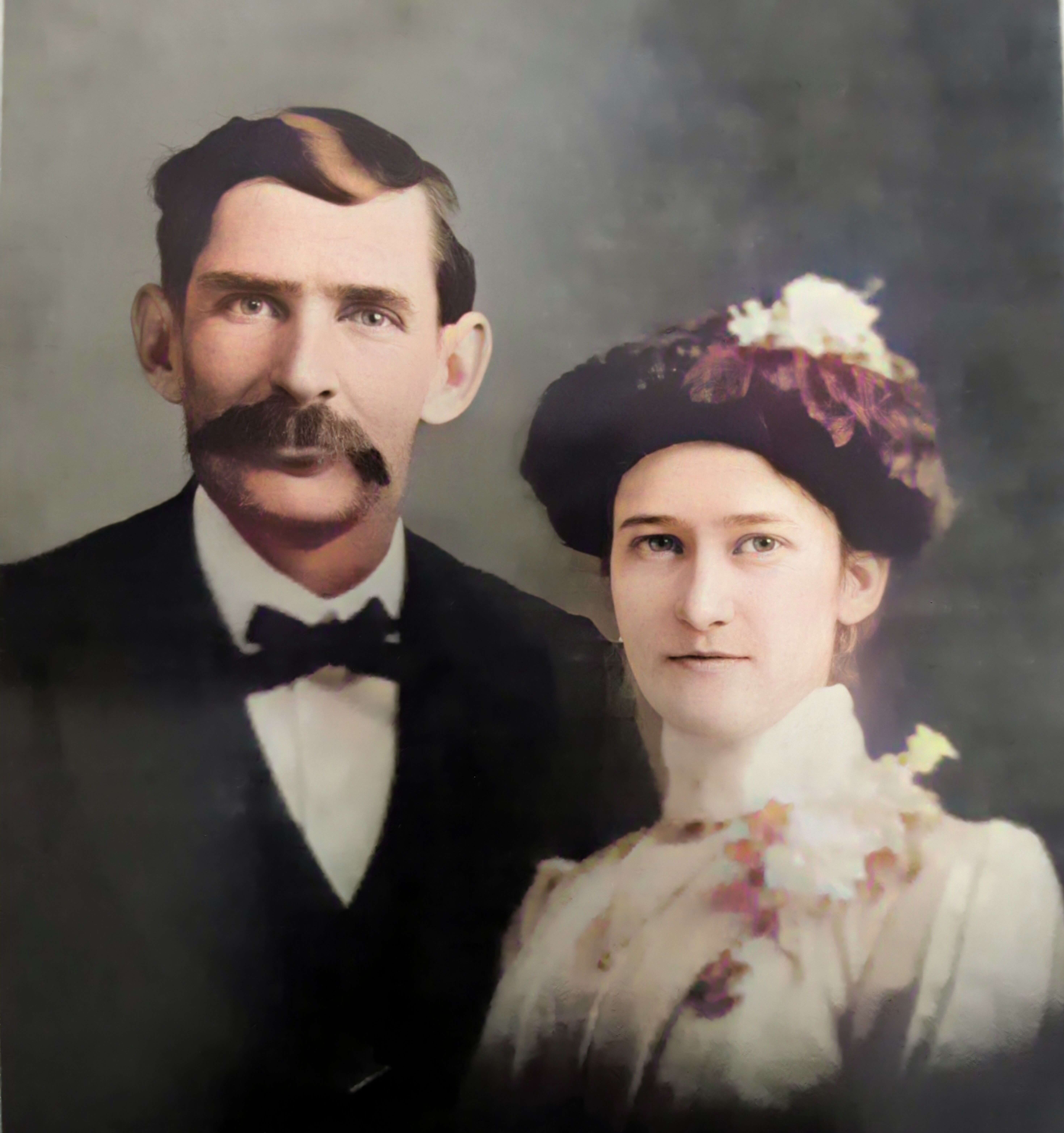
Wedding photo Joseph Madison Blazer Minnie Mae Peters (courtesy of Lisa Egner)
And finally, we want to look for renters and owners. If a family rented, a capital “R” was entered on the census. Those who owned their property were listed with a capital “O”. Since the black squares are “Farm Units” we wouldn’t expect to see a square on the map for every house. If our hypothesis is that the enumerator started on the west side, we could count the number of owned dwellings listed in the census until we get to the family living in question. Then we would count them on the map, going east. Again, it’s not exact, but it’s a whole lot more than what we knew about the address Route 2 Frazier Pike when we started!
 Google Drive is giving some of their competitors a run for their money. This free google tool is just what genealogists are looking for to create, consolidate, and organize their files.