Sanborn Fire Insurance Maps for Genealogy
Show Notes: Discover Sanborn Fire Insurance maps with Julie Stoner of the Geography and Map Division of the Library of Congress. Learn the best search strategies, how to download the Sanborn maps for free, and hidden online resources! Sanborn maps are an invaluable tool for family history because they provide an up-close look at the places where your ancestors lived.
Watch the Video:
Show Notes
Resource: Download the ad-free Show Notes handout
(Premium Membership required)
Sanborn Fire Insurance Maps for Genealogy
(This interview has been minimally edited for clarity.)
Lisa: Today we’re talking about Sanborn fire insurance maps and how we can use them for genealogy. They’re available at the Library of Congress. Here to tell us more about that is Julie Stoner. She’s a reference specialist in the geography and map division of the Library of Congress.
Julie: Thanks so much, Lisa. Happy to be here.
I adore the Sanborn fire insurance maps because they give us such a unique perspective and view of our ancestors’ world.
What are Sanborn Fire Insurance Maps?
Start us off and tell us exactly what are Sanborn fire insurance maps?
Julie: The Sanborn fire insurance maps are a uniform series of large scale maps. They date starting from about 1867, though, they mainly start in the 1880s, and they run mostly through the 1950s. There are some from later dates as well.
It was a company started by a man named D.A. Sanborn. He was drawing these maps at a building level to sell to fire insurance companies so that they could then assess how much to charge people for the fire risk of their building. We use them for a lot more things today than they were originally intended for because they show the building level details of a city.
We have over 12,000 cities and towns represented. Some smaller towns may only have a few sheets. But the larger cities may have multiple volumes. They would go back and create a new map every 10 or 15 years or so. Therefore, you can really see how a city changed over time and how the buildings changed over time, and how a neighborhood was built. These maps can be used for all sorts of things now.
Lisa: I love the fact that they have such detail and are really unique. There really aren’t any other maps quite like these, are there?
Julie: It’s true. We do have other maps, like real estate atlases, and things like that of maybe a few cities, here and there, like Washington D.C. or New York. We have land ownership maps, but nothing of quite this scale or detail.
Sanborn Fire Insurance Maps Online Collection
Lisa: Let’s talk about the scale of the map collection. At the Library of Congress you have the physical map collection, and then there’s the collection that we can access online. Tell us a little bit about the scope of the collection? And does it vary whether we’re online or in person?
Julie: It does vary a bit because of copyright restrictions. As I said, we have about 12,000 different cities and towns represented, that equals over 700,000 map sheets. So, that’s a that’s a lot of sheets of maps. And a few years ago, the library, in conjunction with a third party, took on a project to scan all of the public domain Sanborn maps. Public domain means that there are no copyright restrictions on those maps. So that included anything published before 1922 at that point. Then anything published before 1964, in which the copyright wasn’t renewed. The library took on this project to scan all those, and those are completed and are all online on our website and can be downloaded.
That copyright date is now a rolling date. This means that there are now maps between 1923 and 1926 that are public domain that we haven’t scanned yet, and we are working to get those scan to get those online. And as soon as new maps come into the public domain, we hope to process them and upload those when that happens. So, a very large chunk of the Sanborn maps are online. But, if they are not, you can always come and see them in person as well, because we do have the physical copies.
Sanborn Map Resolution
Lisa: You mentioned that the part that the part of the collection that is in the public domain is available online. And they’re downloadable. Are those pretty high-resolution maps, so that we’ll be able to use those in our own genealogy projects?
Julie: For sure! They are definitely high resolution. The library scans them at the highest resolution that we can and so there’s actually a variety of files that you can download. We have JPEG images, which are a bit lower quality but are good for something like PowerPoints or computer screens. And then we have our TIFF files, which are the largest high-resolution files which have. These are a good size for printing.
Lisa: I know that the online collection, which I think most of our folks would be interested in accessing from home easily, is at the Library of Congress at the loc.gov website at https://www.loc.gov/collections/sanborn-maps. Tell us a little bit about what we’ll find there on the website.
Fire Insurance Map Research Guide at the Library of Congress
Julie: Sure, so that link that you said is a landing page for our digital images. Let’s start with the fire insurance map research guide that we have that is about our fire insurance maps in general, not just the Sandborn maps. There are a few other companies though Sanborn took those over in time. They became pretty much became the only one.
On the research guide page, there’s a large section on the left side of the page that says Sanborn Fire Insurance Company Maps. If you click on that, you will find a number of links to help you with your research of the Sanborn Fire Insurance Company maps.
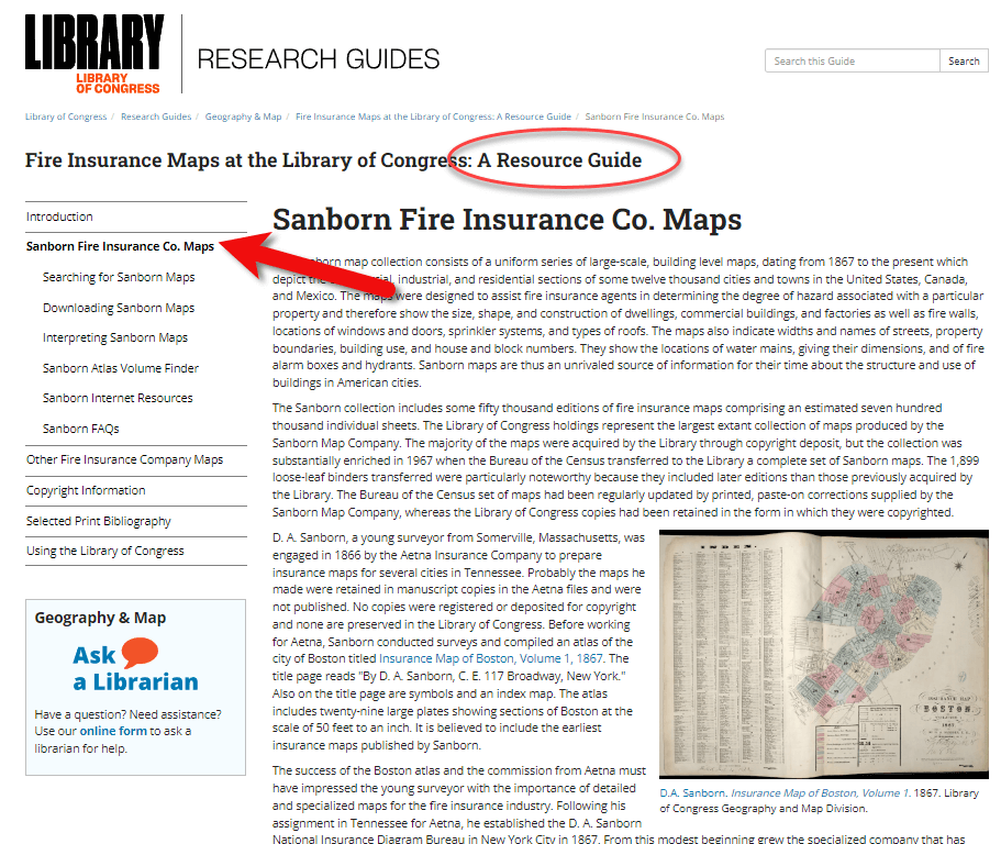
The Research Guide at the Library of Congress
How to Search for Sanborn Maps
I want to point out the easiest way to find the maps. Under the searching for Sanborn Maps tab you will see some information including a link to our Sanborn Fire Insurance Map Checklist. This is the easiest way to find the maps that you’re looking for. It will take you to our fire insurance map index. And this is the easiest way to search for maps.
It’s so large that it can be a little overwhelming. This checklist is taken from a 1981 publication produced by the library that lists all of the Sanborn maps that we have in our collection. While the library has the largest collection of Sanborn maps in the world, we do not claim to have every one ever made. We are missing some. For example, if you found a map at your historical society that is not on this list, it just means that we don’t have it in our physical collection. Not that it doesn’t exist.
You can search by state at the Map Index. If you click on U.S. from the drop-down menu, you’ll find all the states. Scroll through and pick your state. I live in Virginia and I was born here, so I will search for Virginia. I will then see a list of hyperlinks with all of the cities available with Sanborn maps in the collection. Scroll through here and click on the city of interest. For example, if you want to click on Richmond you will get the list of Richmond maps here at the library. It’s a table and on the far left side you will see the date of the volume. And then you will see the number of sheets in that volume. Other geographic areas included sometimes in larger cities. The Sanborn Map Company would pick some areas farther outside the city to include in that volume, perhaps a few sheets. You’ll see a column called Comments which is mostly about the physical binding of the maps your library. And then a column called Website. If you click on the website link it will take you to the digital images.
Why are there multiple dates on Sanborn maps?
And just one other note about the date. If you look at the date, sometimes it can look a little confusing because you’ll see two dates listed. For example, volume 1924 through April 1950. So what’s happening here is that starting in the mostly the 40s and 50s, the Sanborn Map Company, decided it was faster, instead of making an entirely new map to cut and paste over an old map. So, this 1924 date is the face of the map. The 1950 date is the last time that they updated it. So, it’s really showing a 1950 era Richmond, but they’re just using that base map of 1924.
Downloading Sanborn Fire Insurance Maps
When you click through to these digital images, we can download them. Click on an image and you will see in the center of the screen the map that you can scroll in and out of, and then at the bottom underneath the image, you’ll see the download link. You’ll find that there are several options for JPEG images, a GIF file, and then the high resolution tiff file. It’s pretty great. We’re very happy that a lot of these are now online for researchers to use from outside of Washington, DC.
What do the colors and symbols mean on Sanborn maps?
Lisa: And when you look at these maps, there’s a lot of detail. There’s color coding, and all kinds of markings. Do you have resources on the website to help people interpret the map?
Julie: Sure we do. The best method first is to look at the first page of a volume. If you zoom in you will see that there is a map key. It’s a box usually at the top or the bottom of the sheet. That is going to show you what the colors and the symbols in each volume mean.
Different cities have different unique characteristics, and the Sanborn Map Company would map those. So, not every map is going to have every symbol. The key at the front is a really good way to see what specifically applies to that volume.
For example, pink typically means brick. Yellow typically means it was made out of frame, or wood. Green can change. I’ve seen it as cement, I’ve seen it as special, not exactly sure sometimes what that means. The colors indicate the type of building materials, and then you will see what the hash marks or the circles or the x’s mean, in various buildings. There are a lot of abbreviations that the Sanborn Map Company uses as well. D typically stands for dwelling, S for store.
If you want to see an entire list of the symbols, we have a great resource back on our research guides page. Go back to the research guide to the Interpreting Sanborn Maps section on the left. That’s going to tell you a lot more about the colors, the symbols, things like that.
If you go to the Internet Resources, under Websites, there’s a list called Sanborn Map Abbreviations and Legend created by Environmental Data Resources, who are the copyright holders of the Sanborn maps. They’ve created this great PDF that shows the most common abbreviations and symbols used to the Sanborn fire insurance maps. It’s pretty comprehensive.
Sanborn Fire Insurance Map Search Strategies
Lisa: That’s a fantastic resource! If we do the search and we don’t see the town that we have in mind in that list, is there another way or any other way to search to figure out if it is part of a bigger map? Perhaps it’s just too small of a town to have its own map?
Julie: That’s a great question. If it’s a really small town and you don’t see it on the list, the other thing you can do is search back on the index page. The main index page under the full text field. For example, there might be a few sheets of a smaller town on a bigger city. You can search for that in the all full text fields. That will search the other geographic location that we saw, like in Richmond. So say if we typed in Manchester, and we did a search for that. You would see that it’s here as well under Richmond, as well as its own city. So, you can see that maybe it had earlier sheets here in Richmond. If you don’t find it in the search, and you don’t find it in the search fields, and if you don’t find it in the list, then it’s likely that one was not made at that town. Unfortunately that does happen. A lot of small cities and towns just don’t have them sometimes.
Searching for counties and regions in Sanborn maps
Lisa: Well, that brings up another question. Are these always sorted by town or city? Or might we even see a county or even some other kind of regional area described in a map?
Julie: That’s a great question. You do sometimes see counties, I can think of an example off the top my head if you go to California, for example. If you scroll down to Los Angeles, you’re going to see that you have the city of Los Angeles, but then you also have Los Angeles County. That’s going to cover some of the county areas that are outside of the city itself. Typically they’re covering things like factories or industrial areas, or things of that nature, but you never quite know.
Another example would be in New Jersey. If you go to New Jersey, and scroll down to New Jersey coast which includes several different seaside towns. This would be an example of when you might want to do the full text search if you didn’t find it in the list. For example, New Jersey Coast includes Longbranch, and Monmouth Beach, etc. All of these volumes are kind of scattered down the coast.
I like to say that, for every rule for Sanborn maps, there’s an exception. It would be worth perusing that list just to see what other gems are out there are maybe very close by areas that would be worth taking a look at, even if we do find our cities listed or in a search.
The Sanborn Fire Insurance Map Index
Lisa: I can imagine there was a lot of effort that went into the indexing part of this collection, just getting all these cities and counties and everything listed. Was that work that the Library of Congress had to do? Or was that given to you by the company who now owns the copyright on Sanborn? And does it include anything besides a geographic place such as for example, any map with a saloon or any map with a particular feature?
Julie: That would be pretty amazing! Unfortunately, no, we don’t have anything that would list every saloon ever found, though, if somebody wanted to do that project, we’d be happy to take that.
This list was created by the Library of Congress in 1981, and we’ve added to it as we gained new material. The library is always looking for Sanborn maps that we don’t have in our collection. And when we find them, we do try and acquire them and then add them to our index. So, this particular list was created by staff at the library in 1981.
Lisa: What made me think of that question was I know that the David Rumsey collection out at Stanford is now working with and experimenting with a special type of OCR to pull that kind of text off maps. It’s amazing to see what technology might be able to do for us in the future.
Sanborn Map GIS Project
Julie: It is amazing what technology could do. And you’re right, there is a great project going on right now called machine reading maps that is experimenting with pulling the text out of the Sanborn maps to then create new products out of that.
We also have a new GIS project. GIS is geographic, geographic information systems. It’s basically putting information on a map so that you can see it and comprehend it at a glance.
One of the problems that we were having with our Sanborn maps, especially for our very large cities, like New York, LA, Chicago, is that there are so many volumes covering that city, and people would want to know where their exact address was. Well, there are, let’s say, seven or eight volumes of New York City. Which volume includes that address, right? So, we’ve created what we’re calling the Sanborn Atlas Volume Finder. You can find the link on our resource guide page. Click the link and you will see a map of the country. It’s going to pinpoint our current volume blinders.
We are hopefully going to be making more as we go. But basically, the first map is an index of what we have. Tight now we just have Los Angeles, Chicago and Detroit. We’re working on getting Washington DC and New York City out.
But say, for example, you’re interested in a map of Detroit, or an address in Detroit. If you click on Detroit on the pink pin, you can then click on the Sanborn volume finder. That’s going to take you to the Detroit map. It’s going to show you exactly what areas are covered in Detroit. It’s going to show you the extent of the Sanborn maps for the different years that it was mapped in Detroit.
If you look on the left side of the screen you’ll see the legend. This is a range of years for each set of maps that was created. You might see 1884 to 1896 and then 1897 to 1899. You can click the years on and off. So, if you just wanted to know the earliest maps of Detroit, you can see where it was mapped. And you can enter your address in the upper right corner of the screen. That’s going to pinpoint for you the address. Then when you click on it, it’ll tell you the volume where you’ll find the map, and a link that’ll take you to the digital images. So you don’t have to guess which volume your address is in anymore. It will tell you whether the digital images are available, or if the map is not available online, you can contact us to learn more about it.
Lisa: What an amazing tool. It’s exciting to think that will continue to expand particularly for these really big cities where like you said it, it’s like a needle in a haystack with the addresses.
Julie: Yes, there are a lot of volumes for some of these cities. It can be really difficult without expert knowledge how to find your address. We feel like this is really going to help researchers in diving deeper into the Sanborn maps and really finding what they’re looking for.
Accessing Offline Sanborn Fire Insurance Maps
Lisa: You mentioned that sometimes you’re going to see that it is not available online. That might be a copyright issue or something else. Explain to us a little bit about what our options are for getting access to a map that might only be available in person the Library of Congress. How might we go about the in person visit, or making a request online to get a copy?
Julie: It’s the geography and map division policy that we will not scan or send items that are possibly under copyright protection. In the case of the Sanborn maps, if they were renewed or after 1964 then they are copyrighted, so we can’t send those electronically to you. You can make an in person visit to the Library of Congress reading room. We’re open Monday to Friday 8:30 to 5:00, and we will pull out anything you want to see.
Another option is that these volumes have all been scanned in black and white by ProQuest, a subscription database. Those are all scanned in black and white. A lot of universities and public libraries subscribe to the ProQuest database. Go to your public library and ask if they subscribe to the ProQuest database. If they do, you can see them there, and you can download them. However, those are black and white, so that’s a little bit not as helpful sometimes if you’re looking for building construction, and things like that.
There is also on our research guide page, under Internet Resources a link called the Union List of Sanborn Maps. This is a list compiled by the University of California at Berkeley of other institutions that have Sanborn maps other than the Library of Congress. So if, for example, you are in California, and you can’t make it to the library, you can see if other institutions also have those physical copies that you could go to that institution to see.
Lisa: I’m familiar with ProQuest. Do you happen to know, is there one place where you can look up and see which libraries subscribed to ProQuest? Or is that just too much to ask?
Julie: I think you would have to do that individually by library. I’ve never seen a master list. But I find that librarians are usually very helpful people. So, if you called your local library or university library, I’m sure librarians there could tell you help you track it down.
The Growth of the Sanborn Map Collection
Lisa: So it this indeed a growing database? And do you continue to get both stuff that can go online as well as maps that will just be available in person?
Julie: We are always looking for maps that we don’t have here in our collection. Usually, most of those are going to be more recent, like 1950s, 1960s and 1970s maps. The library gained most of our early collection from copyright deposit. It used to be that you had to send in a physical copy of something for to get it copyrighted and that’s how our collection was built. We are still always looking for new updated ones that we don’t have. It is a growing collection. I wouldn’t say that we’re receiving them every day or anything. But when we do find them, and we do like to acquire them.
Final Thoughts on Sanborn Maps
Lisa: Wonderful. Well, before I let you go, you are the guru when it comes to the Sanborn Fire Insurance Maps over at the Library of Congress. Anything else that we should really know about, or look for as we’re working with these Sanborn maps?
Julie: That’s a good question. First, I want to say that we always welcome questions to our division. On the left of the research guide, or on our main library of congress homepage, there’s a link that says Ask a Librarian, and you’re welcome to send us any questions that you have, that we haven’t answered on our research guide, or that you’re confused about. We’re always happy to answer questions.
The Sanborn maps are a fantastic resource for doing genealogy, for finding out more about the town you lived in, and the buildings that were there, and the types of buildings. A lot of the buildings will say what was in them, for example, a candy shop or a hat shop or whatnot. So, they’re a great resource to just find out more about the town. There’s always more to learn about them. I’m still learning about things that I didn’t know about Sanborn maps, years later.
Lisa: Julie, thank you so much for coming and sharing this terrific collection, and giving us such a unique view of the places where our ancestors may have lived. I’m sure you’ll be getting many inquiries through Ask the Librarian.
Julie: Yeah, dive in, reach out. We’re here to help.
Lisa: thank you so much for joining us here today.
Julie: My pleasure. Thank you.
Citing Sanborn Maps
Julie: The Library simply requests an attribution to the Library and the Geography and Map Division when publishing material from its collections, the format of the citation is up to you.
Resources
Download the ad-free Show Notes handout for Premium Members.
Genealogy Gems Podcast Episode 214
The Genealogy Gems Podcast Episode 214
with Lisa Louise Cooke
In this episode, Irish expert Donna Moughty joins host and producer Lisa Louise Cooke to talk about Irish genealogy to help you get a jump on yours before everyone starts talking about their Irish roots on St. Patrick’s Day next month! Also in this episode:
- Your DNA Guide Diahan Southard has DNA news
- Other listeners write in with inspiring successes
- Michael Strauss musters in with tips on finding your ancestors in the five branches of the U.S. military.
NEWS: MYHERITAGE DNA MATCHING UPDATE
The MyHeritageDNA test matching algorithm has gotten better?AND they’ve added a chromosome browser. Time to test with MyHeritage DNA or upload your results from another company for free? Click here to read all about it!
MAILBOX: LISTENERS ON FAMILY HISTORY VIDEOS
Muffy in Seattle sent this link to her family history video. Great job!
Melissa asked about finding copyright-free music to add to family history videos. Lisa’s tips:
Unfortunately, free royalty-free music sites are few and far between.
You’re smart to be cautious because if you were to put your video on YouTube they have the technology to identify any song that is used that is a violation of copyright.
YouTube does make free music available:
- Sign into YouTube with your Google account
- Click on your picture in the upper right corner and go to your Creator Studio.
- Upload your video (you can keep it private if you wish) and then on the video page click “Audio” (above the video title).
- Choose among the many music tracks there.
- Once you’ve added a track and saved it, you should be able to download the video with the music included.
The other source of music I use is music that comes with the programs I use (Animoto and Camtasia).
GENEALOGY BUSINESS ALLIANCE
GBA Buzz game for RootsTech 2018; Play the game. See websites for complete rules.
Lisa Louise Cooke uses and recommends RootsMagic family history software. From within RootsMagic, you can search historical records on FamilySearch.org, Findmypast.com and MyHeritage.com.
![]()
Keep your family history research, photos, tree software files, videos and all other computer files safely backed up with Backblaze, the official cloud-based computer backup system for Lisa Louise Cooke’s Genealogy Gems. Learn more at https://www.backblaze.com/Lisa.
INTERVIEW: DONNA MOUGHTY ON IRISH RESEARCH
The following review appeared in the January 2018 newsletter of the Midwest Genealogy Center, Mid-Continent Public Library:
“If you want a quick guide on how to get started on Irish research, this short, four-page guide is an excellent resource. This guide will help you start your research in the United States, so you can figure out where in Ireland your ancestor came from. It is organized into 12 steps with helpful websites added. This guide is the first in the Irish Research Series by Donna M Moughty.”

Donna Moughty, shown left with Lisa Louise Cooke, is a professional genealogist and former Regional Manager for Apple Computers. She has been conducting family research for over 20 years. She teaches classes for beginners and lectures on a variety of subjects including Internet, Irish research, and computer topics. In addition, she provides consultations, research assistance, and training. She is a member of Association of Professional Genealogists and the Genealogical Speakers Guild.
Websites mentioned in their conversation:
Donna’s Irish guide series – Discontinued
Preparing for Success in Irish Records Research – Guide #1 (reviewed above): Without the right preparation, researching in Ireland can be frustrating! Before you jump the pond, start your research at home to determine a place in Ireland, as well as details to help differentiate your person from someone of the same name. This research guide will walk you through the process of identifying records in the US to set you up for success in your Irish research.
Irish Civil Registration and Church Records – Guide #2. Civil Registration for all of Ireland began in 1864, with Protestant marriages dating back to 1845. Even if your ancestors left before that date, they likely had relatives that remained in Ireland. Prior to Civil Registration, the only records of births (baptisms), marriages or deaths (burials) are in church records. This Reference Guide will explain how to use the new online Civil Registration records as well as how to identify the surviving church records for your ancestors in Ireland.
Land, Tax, and Estate Records – Guide #3 (NEW!). Had the Irish census records for the 19th century survived, Griffith’s Valuation, a tax list, would not be one of the most important resources for Irish researchers. Without any context, however, it can just seem like a list that includes lots of people of the same name. This Guide explains how and why Griffith’s Valuation was done, and how to use it to glean the most information about your family. Once you know your ancestor’s locality in Ireland, Griffith’s Valuation can place them on a specific piece of land between 1846 and 1864. After Griffith’s Valuation, the Revision Books allow you to follow the land and in some cases, to the 1970s, possibly identifying cousins still living on the land.
![]()
Start creating fabulous, irresistible videos about your family history with Animoto.com. You don’t need special video-editing skills: just drag and drop your photos and videos, pick a layout and music, add a little text and voila! You’ve got an awesome video! Try this out for yourself at Animoto.com.
MyHeritage.com is the place to make connections with relatives overseas, particularly with those who may still live in your ancestral homeland. Visit www.MyHeritage.com
MyHeritage.com is the place to make connections with relatives overseas, particularly with those who may still live in your ancestral homeland. Click here to see what MyHeritage can do for you: it’s free to get started.
MILITARY MINUTES: 5 BRANCHES OF THE MILITARY
Each of the military branches is listed below, detailing information about when each was organized and resources available to genealogists on your ancestors who served in any of these branches.
United States Army. The largest of the five military branches dates back to June 14, 1775, during the early days of the Revolutionary War. Prior to the formation of the Army, each colony had companies and battalions of Associators and local militia. With the war, the need for a professional standing army to fight the British saw the formation of the Continental Army.
With the end of the Revolutionary War, the Army disbanded in 1783 after the signing of the Treaty of Paris. Later in 1796, two legions formed under the command of General Anthony Wayne would later become the nucleus of the United States Army. The Encyclopedia Britannica published this nice article on the history of the Army from its inception to the present.
A number of excellent genealogical resources are available to search for ancestors who served in the United States Army since the beginning. These databases are found on Ancestry, Fold3, and Family Search. One of the largest collections of records covers the United States Regular Army enlistments from 1798 to 1914 (available by subscription at Ancestry.com). Searching the card catalogs of Ancestry.com, Fold3 and FamilySearch will yield many databases that contain information about soldiers who served, and sacrificed their lives with the Army over the last two centuries.
United States Navy. The United States Navy dates from October 13, 1775 when it was officially established by an Act passed by the Continental Congress. At the end of the Revolutionary War it was disbanded, and again reestablished under the Naval Act of 1794 which created the Navy as a permanent branch of the military.
The history of the Navy and technology can be divided into two major eras. The earlier period, called the “Old Navy,” was the age of wooden sailing ships, and still later came the birth of the ironclads during the Civil War. The later period called the “New Navy” occurred with further innovations in late nineteenth century as the United States transformed into a global power recognized the throughout the world.
The United States Navy website has a nice background history of the service. Numerous databases and searches for records of the Navy covering multiple war period detailing pensions, continental sailors, muster rolls, ships logs, and cruise books are located on Ancestry.com, Fold3 and FamilySearch. Consult each database individually for records of interest.
Another organization related to the Navy is the United States Merchant Marines. Although not officially a branch of the military, the Merchant Marines sacrificed and lost lives since the days of the Revolutionary War, carrying out their missions of supply and logistics during times of war. Here’s an excellent website on the history of the Merchant Marines.
United States Air Force. The modern day Air Force dates from September 18, 1947, when it was formed as part of the Security Act of 1947. The Air Force and aviation history began under the authority of the United States Army, starting on August 1, 1907 when it was organized under the name of the Aeronautical Division of the Signal Corps. Over the next 30 years the service changed names several times:
- Aviation Section of the Signal Corps (1914-1918);
- Division of Military Aeronautics (1918);
- Air Service of the United States Army (1918-1926);
- United States Army Air Corps (1926-1941);
- United States Army Air Forces (1941-1947).
In that final year, it was separated as its own organization as it is known today. Click here for a complete history of the Air Force from 1907 to the present.
Two excellent online sources covering the early history of the Air Force from World War I and World War II are located on Fold3:
- Gorrell’s history when part of the AEF in 1917-1918 and
- Missing air crew reports during the World War II
United States Marines. This elite branch of the military began with the organization of the Continental Marines on November 19, 1775. The mission of the Marines initially comprised ship-to-ship fighting, security onboard naval vessels, and assistance in landing force operations. This mission would continue to evolve over the years. At the end of the Revolutionary War, the Marines were disbanded on October 4, 1783.
Along with the Navy, under the Naval Act of 1794, the United States Marines were again re-established and would serve faithfully in every major war period and in peacetime between conflicts. The Marines will forever remain true to their motto of “Semper Fidelis” or Always Faithful as they continue to live up to their long-running tradition of honor and service. Click here to watch an interesting and accurate history of the Marine Corps is viewable online on You Tube.
Ancestry.com has an excellent online genealogical resource for discovering Marine Corps ancestors: fully searchable Marine Corps muster rolls from 1798 to 1958 for enlistees.
Coast Guard. The history of this seagoing service dates back to August 4, 1790. Established as the Revenue Cutter Marines under the direction of Alexander Hamilton, the name was changed in 1894 to the Revenue Cutter Service until 1915. That year, an Act of Congress was passed and signed into law by President Woodrow Wilson called the “Act to Create Coast Guard.” The United States Live Saving Service and Revenue Cutter Service came together. Later, in 1939, the United States Light House Service was added to form the modern day United States Coast Guard.
The complete history of the United States Coast Guard from 1790 is on the Historians Office. It includes information about each of the separate organizations that came together to form the Coast Guard at. Ancestry.com has a collection of casualties of the Navy, Marines, and Coast Guard. Very few additional online sources are available online for this branch of the service. Researchers must access these documents and records onsite at the National Archives in Washington, DC.
Military Minutes Case Study

By Michael Strauss
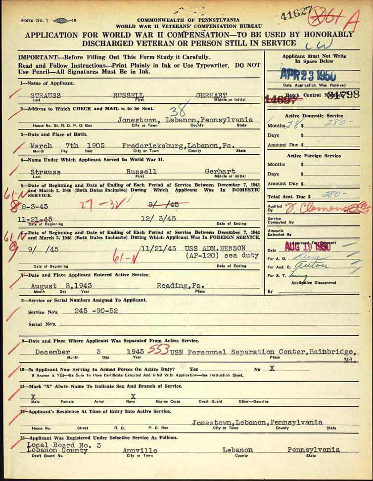
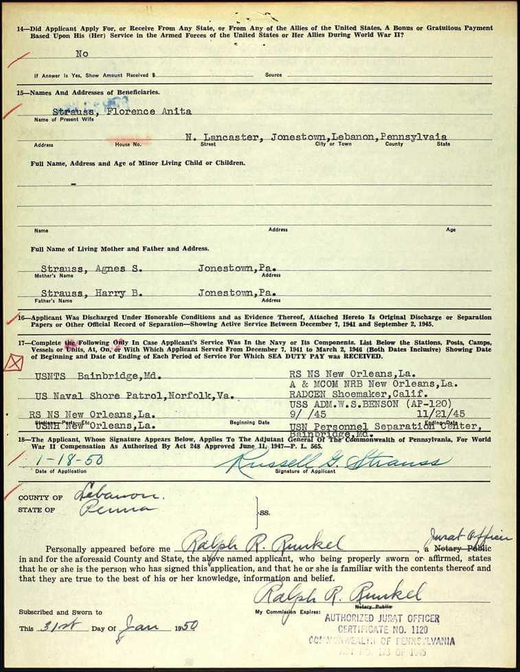
Subject: Russell Strauss
Died: December 27, 1981-Jonestown, PA
Son of Harry B. Strauss & Agnes S. (Gerhart) Strauss
Over the last 30 plus years doing genealogy research, I’ve discovered that nearly all of my family members who served in the military were in the United States Army. But I have been occasionally surprised to find relatives who served in other branches of the military.
On the paternal family several years ago one of my cousins gave me a box of photographs. One of the images was marked Russell G. Strauss. He wore the uniform of the United States Navy during World War II. I recognized his name and knew that he was my grandfather’s first cousin. I was 16 years old when he died and didn’t know him very well.
His uniform indicated that he was a third class petty officer in the Navy during the war. I looked further at his uniform and noticed a diamond shaped “S” as part of the insignia. This military occupation indicated that he was a specialist that would require further research. I spoke with a couple of my older family members who knew Russell. All of my family interviewed said that he in the military police (M.P.) during the war. With additional research, I discovered that his insignia was that of the Shore Patrol. When I compared what my family said to me and his uniform told me the information matched very closely.
I found on Ancestry his application for compensation from the Commonwealth of Pennsylvania in 1950 when he served in the Shore Patrol in Norfolk, Virginia as part of his military duty (inserted below). Putting information from his photograph together with what my family members shared with me helped answer questions I had regarding of my relatives.
![]()
PRODUCTION CREDITS
Lisa Louise Cooke, Host and Producer
Sunny Morton, Editor
Vienna Thomas, Associate Producer
Hannah Fullerton, Production Assistant
Lacey Cooke, Service Manager
Disclosure: This page contains affiliate links and Genealogy Gems will be compensated if you make a purchase after clicking on these links (at no additional cost to you). Thank you for supporting this free podcast and blog!

Resources
Premium Podcast Episodes
Premium Podcast Episodes As a Genealogy Gems Premium Member you have access to the entire back catalog of Premium Episodes! Of course, things do change over time, so occasionally you’ll hear about something that is no longer around (like the Premium Message...Episode 146 – Maureen Taylor’s New Film Project, Genealogy News, and A Fabulous Use for Google Alerts
[iframe src=”http://html5-player.libsyn.com/embed/episode/id/2151213/height/100/width/480/thumbnail/yes” height=”100″ width=”480″ scrolling=”no”]In this episode we discuss the latest genealogy news, one listener’s fabulous use of Google Alerts, and Maureen Taylor’s new history film project.
NEWS:
Google Earth 7
Google as just released Google Earth version 7. Google Earth is an amazing tool for genealogy so new enhancements are always welcome! This new version enables you to explore a number of cities around the world in 3D, from Long Beach, California, to Rome, Italy. The 3D imagery uses the enhanced modeling capabilities, previously found on only mobile devices.
In my video CD Google Earth for Genealogy Volume II I go into detail about 3D models and even give you resources for how you can get your own 3D models of everything from your house, to your ancestor’s home.
Download the new Google Earth 7 and get even more 3D imagery. You’ll find comprehensive and accurate tours of more than 11,000 popular sites around the world, including our growing list of cities where new 3D imagery is available.
A big change with this new version is the tour guide feature which serves as sort of a virtual local expert that suggests places nearby that you might want to explore and providing you with background information on the location. You’ll find the tour guide along the bottom of the screen, and it looks like sort of a film strip of thumbnail images representing various tours that are available. These change based on where you are on the Google Earth globe.
List of updated Google Earth imagery
What’s new in RootsMagic 6 Video
And there a favorite genealogy program that just got a new fresh update. RootsMagic 6 is now available, and you can see what’s new in the newest version of the genealogy database program in a brand new video they’ve published on their website at http://www.rootsmagic.com/webinars/
In the video you will see new features in action such as:
- Online Publishing
- Find Everywhere feature
- Live Timeline View
- WebTags
- CountyCheck Explorer
If you are a current paid user of RootsMagic, you can upgrade for just $19.95. New users may purchase RootsMagic 6 for only $29.95. Order online at http://rootsmagic.com/RootsMagic/
Special Holiday Offer Now through Dec. 20, 2012
Order gift copies of RootsMagic 6 for just $19.95 (plus shipping). You can also order other RootsMagic products at that same $19.95 price. Order the special holiday at http://www.rootsmagic.com/holidayoffer or order by phone at 1-800-ROOTSMAGIC (1-800-766-8762).
The next item here is that the Family Tree Service coming soon to FamilySearch.org
According to a FamilySearch press release, “Within the next few months, FamilySearch will make Family Tree available to everyone on its website. The first of many updates planned for FamilySearch.org, Family Tree will provide a free and engaging way to discover, preserve, and share your family history. Family Tree will also offer specialized tools to make temple work for your ancestors even easier and more convenient.
Watch an Introduction to Family Tree that shows 7 reasons to be excited about Family Tree.
Family Tree will enable you to:
- Save family information into a genealogy tree
- Edit and delete incorrect data, including relationships
- Connect and collaborate with others on shared family lines
- Show where information came from
- Link to online photos and documents
If you have questions about what Family Tree will be like or how it will work, you can log in to a special training website that offers online courses, how-to videos, informational handouts, and step-by-step training.
Get started with Family Tree today by watching the introductory video or reading about it on the training website. Family Tree will be open to everyone in the next few months.
RootsTech conference in Salt Lake City
The Early Bird price for the full 3-Day Pass which gives you everything RootsTech has to offer is $149, discounted from the regular full price of $219
Students: One-day only pass for $89 and students can get a 3 day pass with their student ID for just $39
Getting Started 3 Day Pass for beginners: gives you access to over 30 classes in the Beginner track is just $39 for the early bird price, and the regular price will be $49
Getting Started one-day pass giving you access to a selection of fundamental classes for just $19
I will be at RootsTech 2013 teaching a variety of classes in addition to my booth in the exhibit hall, and some free demo classes I’ll be doing in the Demonstration Area of the Expo hall. So I hope you get RootsTech 2013 on your calendar because I look forward to seeing you there.
Ireland – National Archives launches new website
The National Archives of Ireland has launched a new genealogy website at http://www.genealogy.nationalarchives.ie/ which will initially host the 1901 and 1911 Censuses, Tithe Apportionment records from 1823-37, and Soldiers’ Wills from 1914-17.
New at ScotlandsPeople
Scottish wills and testaments from 1902-25 now online at the ScotlandsPeople at http://www.scotlandspeople.gov.uk/
Millions of Old Newspaper pages added to FindMyPast
findmypast.com has just published millions of pages of historical newspapers from not only England, but also across Wales and Scotland as well. This collection contains local newspapers for the period 1710-1950. More than 200 titles are included. Go to http://www.findmypast.co.uk/search/newspapers
Ancestry.com launches newspapers.com
On November 29, 2012 Ancestry.com Inc., announced the launch of Newspapers.com, a web site designed to offer a collection of more than 800 U.S. newspapers dating from the late 1700s into the early 2000s.
Comprising more than 25 million pages, Newspapers.com offers a historical and present-day newspapers ranging from the New York Times to small town and local newspapers throughout the United States.
According to Ancestry’s press release “The search capabilities on Newspapers.com are specifically designed for newspapers enabling users to easily search by keywords, location, time period and newspaper name.”
The yearly subscription rate is $79.95 for subscribers and $39.95 for Ancestry.com or Fold3.com members. Newspapers.com also offers a 7-day free trial that can be activated at www.newspapers.com.
Ancestry has launched a new Community Support site at Ancestry.com
You can access Community Support by clicking on “Get Help” at the top of the Ancestry.com homepage. Once on Online Help, you will see a button for “Ask the Community” on the right hand side. That link will take you directly to Ancestry’s new Support Communities.
MyHeritage Buys Geni.com
MyHeritage have just bought our long-term rival Geni.com – and also raised $25million in new funds. As a larger community, the users of MyHeritage and Geni.com will now receive matches with the other website family trees, and MyHeritage’s Record Matching, will benefit Geni’s users, who will get access to historical records never available before on Geni.com.
MAILBOX:
Jessica has a new blog and a question about photo storage: “…after about the 10th podcast in a row where you encouraged us to start our own blog, I finally got the message. I started my very own “geneablog” a couple of weeks ago. I only have three posts so far, but I’m pretty proud of it. Please check it out and let me know what you think. I’d love you to let your listeners know too, because that would be even more feedback! I am writing my blog from the perspective of my relentless quest to better understand the life of one particular ancestor of mine, William Park. I call it “Knowing William” and it writing it really makes me happy.” Visit her blog at http://williamparkfamilyhistory.blogspot.com/
“I recently listened to episode 119 where you talked to Michael Katchen from 1000memories. I went to the site, signed up, and uploaded pics to my first shoe box. In the interview I remember words like “social networking”, “memorials”, and “genealogy”. I am confused. All I saw on the site was my shoe boxes and some not-very-informative FAQs. I know it has been a while, but have they changed the whole premise of the website in less than a year?”
Lisa’s Answer: Congrats on your new blog! Remember posts can be short and sweet, and pack them with searchable keywords so other researchers can find you in Google Search.
RE: 1000Memories. They have indeed changed up the website since the interview. I agree with you, it seems watered down now, and not as obvious as to how to make the most of it. They seem to be focused on “simplicity.”
Barbara Shares A New Use for Google Alerts
“My Great Grandfather, Edmund Charles Clark, was a builder in Bendigo, and many of his houses still stand in Wattle Street Bendigo today. I spent a lovely day photographing them, but I cannot go up and knock on all the doors however! So I have a cute way of finding out just what those houses look like today especially on the inside. I have an alert in Google for “Wattle Street, Bendigo” and it works a treat. Every so often one of the homes goes up for sale or rent, and one of the real estate websites has pictures of both inside and outside. These come up on my search and I get to see inside the homes that are still standing. One is up for rent at present and here are the pictures from Realestate.com.au of 172 Wattle Street. Isn’t it lovely? It is still much in original condition.
The Google alert function is really useful for genealogy, and I first found out about it from Genealogy Gems – so thank you very much for the gem.”


GEM: Maureen Taylor’s new gig – bringing revolutionary war history to film
Pamela Pacelli Cooper, President, Verissima Productions at www.verissima.com
Maureen Taylor, Author of The Last Muster
Revolutionary Voices: A Last Muster Film, Directed by Maureen Taylor with Verissima Productions
Visit Film Site: lastmusterfilm.com
New Gem for Premium Members!
Sign in to your Membership and go to Premium Videos to view the brand new video Genealogy on the Go with the iPad (and tablets too!)
The iPad is built for hitting the road and is ideally suited for family history due to its’ sleek lightweight size, gorgeous graphics and myriad of apps and tools. In this class I will teach you “the tablet mindset”, the best apps for the tasks that genealogists want to accomplish, and my Top 10 list of iPad Tips and Tricks. By the end of class you will be able to turn your iPad into a family history powerhouse!
