Land records are some of the most underutilized, yet most useful, records available in genealogy. Often, they are the only records which state a direct relationship between family members. They can also be used to prove relationships indirectly by studying the land laws in force at the time. Sometimes they can even be used to locate an ancestor’s farm or original house, so that we can walk today where our family walked long ago.
Land records exist in the United States in abundance for most locations. Read on to learn how to find land records and how they can help you scale seemingly impossible brick walls in your genealogy research. Our guest blogger is Jaye Drummond, a researcher for Legacy Tree Genealogists.
The History of Land Records
The search for new land is one of the main themes of American history, so it makes sense that land records would be an important part of researching that history.
The right to own real estate was not universal in most of the countries from which the majority of American immigrants came. And even when it was possible to own land legally, it was often too expensive and thus out of reach for most people.
As a result, the lure of vast expanses of relatively cheap and plentiful land has proved irresistible to millions of immigrants to American shores over the course of the past 400 years.
The land records created throughout those years to document ownership of all that real estate have accumulated in seemingly limitless amounts. Even in the face of catastrophic record loss in some locations, land records are generally plentiful. They usually exist from the date of formation of colonial, state, and county governments, where the records still exist.
Information Contained in Land Records
Due to the paramount importance of land ownership in what would become the United States, land records often are the only records in which you will find your ancestors mentioned in some areas.
And there’s good news! Land records often state relationships or provide other, indirect, evidence of family relationships. This makes them an invaluable resource for genealogists.
Understanding what kinds of land records exist, where to find them, and how to use them is often critical to solving genealogical mysteries.
4 Types of Land Records and How to Use Them
There are four different types of land records that can play a vital role in your family history research. Let’s take a closer look at what they are and how to use them.
1. Land Deeds
The most essential land record is the deed. Deeds document the transfer or sale of title, or ownership, of a piece of land or other property from one party to another.
Deeds usually concern land, or “real” property, but they also often mention moveable or “chattel” property, such as household goods and even enslaved persons.
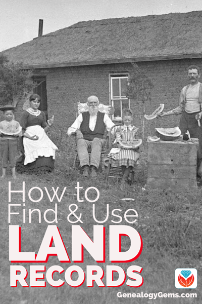
Example of deed index, courtesy of FamilySearch
They sometimes, but not always, contain explicit, direct statements of relationship between family members. Sometimes this can be a parent-child relationship, but deeds can also include a list of people who are children or heirs of a particular deceased person who owned the land being sold.
Sometimes the language in deeds involving heirs makes it clear that the heirs are children, sometimes not, so some care must be taken not to assume that all heirs are children. Research in other records sets such as probate, census, and church records may make the relationships of the heirs to the deceased land owner clearer.
In the early years of a settlement, and sometimes later, deeds books also often contained other types of transactions, including the sale of enslaved persons and sometimes even wills. These are often records for which no other copies survive. Thus, surviving deed books should always be checked for ancestors and their family members in every jurisdiction in which you do genealogy research.
Also, remember to check published abstracts of deeds if they exist, as witnesses to deeds were not included in most indexes to the original deed books. Witnessing a deed was one of many ways relatives assisted one another, and thus the presence of one of your ancestors as a witness for someone else suggests they had some kind of relationship, which might lead to the discovery of previously unknown ancestors.
Also keep in mind that not all states required the recording of deeds throughout their history, or did not require them to be recorded in a timely fashion.
Pennsylvania is an example of this lackadaisical attitude to record keeping that now seems foreign. When researching land records in Pennsylvania it is important to remember that deeds for an ancestor might have been recorded years, even decades, after the actual transaction took place. Therefore, always remember to check the indexes for deeds and other transactions many years after the person in question died or left the area.
In other states, such as New Jersey, land was sold at the colony and state level for longer than is typical in other areas and thus land records must be sought at the state or colony level up to that time.
In the case of New Jersey, deeds only began to be recorded in the various counties around 1785. Therefore, New Jersey real property research must be done at both the county and state or colonial level.
In the case of colonies and states with massive record loss, such as Virginia, land records recorded on the state level are often the only records that survive for some counties, and thus are critical for success in navigating such “burned” counties.
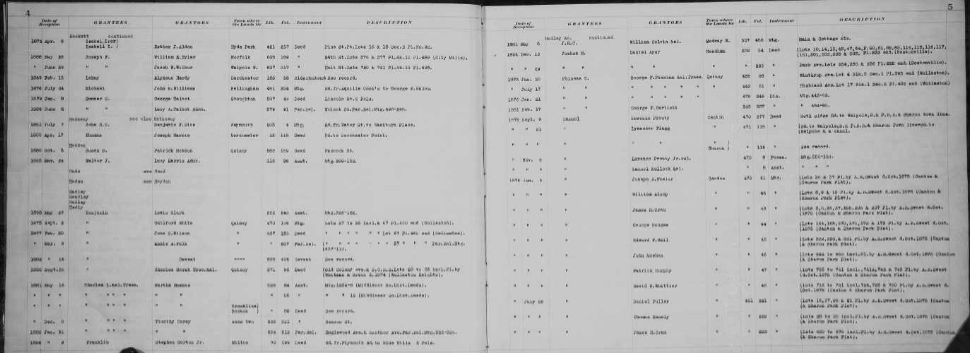
2. Land Grants and Patents
Land grants and patents issued by the various colonial, state and federal governments are also an important resource, including land lotteries in states like Georgia.
In many states, such as Pennsylvania and North Carolina, the original applications, warrants, surveys, and patents or grants still exist and can be searched at the state archives or online.
While these documents do not often state relationships, they sometimes do. That was the case with one of my ancestors whose father had applied for a land patent in Pennsylvania in 1787. He died before the patent was issued in 1800, and thus it was granted to his son by the same name. However, the land patent spelled out that the original applicant had died and his son was the person actually receiving the patent.
Land patents and grants, as well as deeds in general, can also document the dates in which an ancestor resided or at least owned land in a given location. This can assist the researcher in establishing timelines for ancestors. It can also help when it comes to differentiating between two or more individuals residing in a given area with the same name. Anyone dreading research on their Smith and Jones ancestors might just find the solution they seek in those old, musty deed books!
3. Mortgages
Other land records that might prove essential in solving genealogy puzzles are mortgages.
In some states like New Jersey, mortgages were recorded locally earlier than deeds and sometimes survive for earlier years than do deeds.
A mortgage is a promise by a borrower to repay a loan using real estate as collateral—in effect deeding title to the real estate to the creditor if the loan is not repaid.
A similar instrument called a deed of trust, or trust deed, performs the same function with the exception that a third-party trustee takes title if the loan is not paid back in full. In the early years, mortgages and trust deeds were usually contracted with private individuals, but as the banking industry grew in the United States over the course of the nineteenth century, they began to be taken out with banks instead of private persons.
The two parties involved in a mortgage are the “mortgagor” and the “mortgagee.” Indexes can often be found for mortgages using those terms.
However, sometimes early mortgages and trust deeds were recorded in the same books as deeds, so keep an eye out for them.
And remember: the mortgagor is the borrower, while the mortgagee is the creditor.
Don’t be put off by their sometimes-confusing terminology. Old mortgages and trust deeds are some of the most underused land records in existence—yet they can sometimes be the key that unlocks the door to that next ancestor. Don’t overlook them!
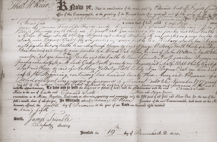
4. Tax Records
One other land record that could crack the case is land tax records. Everyone who owned land had to pay taxes on it, at least in theory. Sometimes, land tax books include notations about one person inheriting land from another, or more commonly, the change in owner’s name from one year to the next can indicate inheritance of the land. The absence of a deed or will showing the transfer might be explained by checking the land tax books.
“14th Dec. 1786 Received of Mr. James Brooks Six pounds, Eighteen Shillings and four pence in full for the balance of Samuel Wood Estate Land Tax for 1784 & Half tax for 85.” John Rodes L. Ds. Image courtesy of MyHeritage.
The Law of the Land: Primogeniture and Genealogy
In some cases, the inheritance and real estate laws of the time might allow you to make a determination of parentage even without a will or deed stating the suspected relationship.
The legal concept of primogeniture, or inheritance of land by the first-born son, was in force in many parts of the Thirteen Colonies until soon after independence, especially in the southern and middle colonies. Thus, when a land owner died, his first-born son would often inherit all or most of his land if he died intestate, or without a will.
The emergence of one man as the owner of a given piece of land in place of the previous owner, either as the seller, or “grantor,” in a deed or in the land tax records, could indicate that the previous owner died and the land was inherited by his “heir-at-law,” the first-born son. There might not be any record of this transfer, so knowing the “law of the land” can prove to be instrumental in cracking the case.
In these and many other ways, land records can be used to find direct and indirect evidence of family and other types of relationships, often when no other record does—or even survives. It is for this reason that land records research must be part of any reasonably exhaustive genealogical investigation.
Where to Find Land Records
In some areas, land records are the only records that survive which state relationships or can be used to provide indirect evidence of them.
They also are useful in establishing biographical timelines for ancestors, and to learn more about their lives. They can sometimes also be used to identify the location of ancestor’s farms and sometimes even their original homes, so that today’s genealogists can often literally walk in the footsteps of their ancestors. But where are those records now?
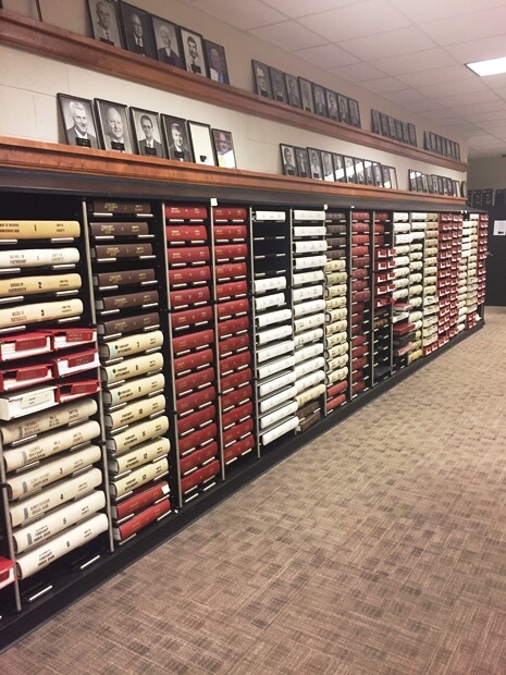
It used to be that if you wanted to do genealogy the right way, one of your first stops had to be at the county courthouse where your ancestors lived. This is still a good practice, as many treasures held within the walls of the hundreds of courthouses scattered across this land are not microfilmed, digitized, or abstracted, and likely never will be.
The Recorder of Deeds and the County Clerk are therefore often the genealogist’s best friends. So, planning a trip to the courthouse or archive where land records are held is still a good idea.
Smyth County, VA courthouse records (Image credit: Margaret Linford.)
But many of us live far away from where our ancestors owned land and lived out their lives. How can we access these records if we don’t have the time or budget to travel to the areas in question?
Thankfully, the digital revolution has made researching land records and other types of documents much easier, but often still time consuming and at times overwhelming.
The land records held at the state level for “state land” states (the original thirteen colonies and the states formed from them such as Maine and Kentucky) are usually indexed. They can often be accessed digitally at the website for the state archives, commercial genealogy sites such as Ancestry.com, or can be ordered via correspondence with the archive.
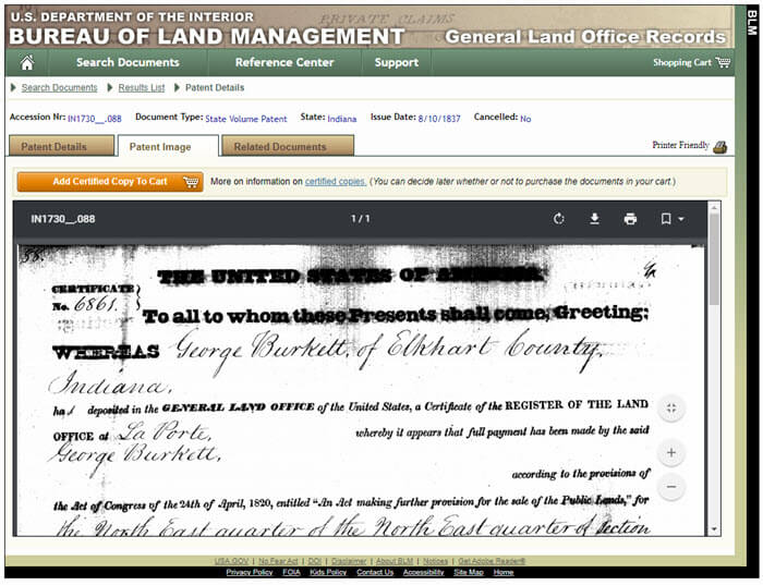
In states that were part of the old Northwest Territory, such as Ohio and Indiana, as well as the other public land states (any state formed under the Constitution that was not carved out of one of the original colonies), grants from the federal government to the first recorded owner of that land can be found at the Government Land Office site created by the Bureau of Land Management. Their website (available here) allows searches for names of individuals who purchased federal land in public land states. You can even view the digital images of the land grants, including the signature of the President of the United States at the time.
Example of a land patent image.
Other types of records associated with federal land, include:
applications for public domain land grants,
Homestead Act applications,
Freedman’s Bureau land records,
and bounty land warrants and applications for veterans.
These are all held at the National Archives in Washington, D.C. Many of these records also state relationships and add rich detail about the lives of ancestors. However, most of these records have never been digitized and must be searched in person or requested via the National Archives’ online order service.
Land records at the county or town level are still held at the local county courthouse or archive, if they survive. Many jurisdictions have digitized their land records and made them available online, in many cases for free. This can sometimes include the entire run of a county’s land records, back to the formation of the county. County clerks and recorders will also sometimes do research via correspondence, though most are unable to do so due to time constraints.
Land Records at FamilySearch
Most importantly in the field of land records research from a genealogical perspective is the massive digitization project undertaken by FamilySearch, the website for the genealogical Society of Utah.
Millions of land records from all across the United States, and even some from other countries, are available at their website free of charge—and viewable either from the comfort of your own home or at a Family History Center or the Family History Library itself, depending on the license agreement FamilySearch has with the original repository.
This vast trove of land records is almost completely unindexed by FamilySearch and will thus not appear in results using their “Records” search page. They must instead be searched in the “Catalog” search page. (Editor’s note: learn how to search unindexed records at FamilySearch by reading our article: Browse-Only Databases at FamilySearch are Easy to Use.)
Despite not being indexed by FamilySearch, the digitized microfilms themselves usually have indexes, either in separate volumes or at the beginnings or ends of the digitized individual deed books.
Most of the digitized land records made available by FamilySearch date from 1900 or before, so a trip to the courthouse might still be warranted for most twentieth-century deeds and more recent land records research. If all else fails, don’t forget to ask the recorder or clerk for help if you have a limited research goal, such as one deed copy—you just might be surprised how eager and willing they are to help.
If the land records you need are unavailable online or are held in a remote location, consider hiring a professional genealogist to go to the courthouse in person on your behalf. Legacy Tree Genealogists has a worldwide network of onsite researchers who can obtain nearly any record that still exists in most areas. Learn more here about how we can assist you in the search for your ancestors and the records of their sometimes only tangible piece of the American dream—land!
(Editor’s note: Our links to Legacy Tree Genealogists are affiliate links and we’ll be compensated – at no cost to you – if you use it when you visit their website. This page includes a discount code for full service projects, or scroll to the bottom of the page for information about their 45-minute genealogy consultations. Thank you for helping to keep our articles and the Genealogy Gems Podcast free. )
Indeed, land ownership was more widespread in the Thirteen Colonies and the United States than most any other nation on earth. So the good news is that there’s a good chance that some of your ancestors were land owners. However you access them, land records are absolutely critical for success in genealogy and should be thoroughly examined whenever possible. You’ll be glad you did.
Jaye Drummond is a researcher for Legacy Tree Genealogists, a worldwide genealogy research firm with extensive expertise in breaking through genealogy brick walls. To learn more about Legacy Tree services and its research team, visit their website here.
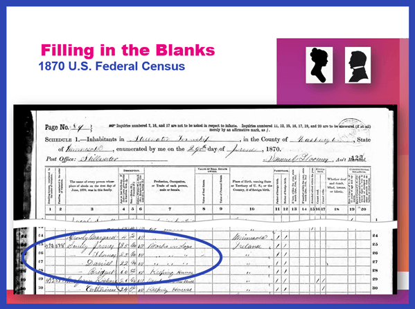
Show Notes: When you find family history information online you MUST make every effort to find the original genealogy record so that your family tree will be accurate! There are 5 reasons to find original records. I’ll explain what they are, and what to look for so that you get the most information possible for your family tree.
If you’re a genealogy beginner, this video will help you avoid a lot of problems. And if you’re an advanced genealogist, now is the time to fix things.
Records come in many forms. Many genealogy websites consider that each name that appears on a document is a “record” when they’re counting records. So, when you hear that 10 million records have been added to a website, it doesn’t necessarily mean that 10 million genealogical documents have been added. It oftentimes means that that’s the number of names that they’ve added.
One document could have a lot of names. In the case of a death certificate, it could have the name of the deceased, the name of the spouse, the name of the informant, and the names of the parents. Each one of those gets counted as a record.
Recently, MyHeritage announced they’ve added 78 million new records to their website. However, many of these records are simply transcriptions, they’re extracting the information from whatever the original source was. That information becomes searchable, and that’s terrific because they are great clues. So, sometimes when you go and look at the records themselves, it turns out that record really is just a transcription. There is no digital record to look at.
Sometimes the website doesn’t even tell you what the original record was. There will be clues, though. You can use those clues and run a search on those words. So, if it talks about a particular location, or type of record, or the name of the record, you could start searching online and find out where are those original records are actually held. Sometimes they are on another genealogy website. But a lot of times, and I’ve seen this more recently, they are publicly available records, oftentimes from governmental agencies. Very recently, we’ve been seeing more recent records that are just selected text. They may be records for people who just passed away a year or two ago.
There are a wide range of places where these types of records can come from. But if that genealogy website got its hands on the record, chances are you could too. And it’s really important to do that.
#2 What’s important to you might not have been prioritized for indexing.
The indexer is a person, or perhaps even an artificial intelligence machine, who has gone through the documents and extracted information and provided it in text form. Sometimes when you search on a genealogy website, all you’re getting is just that typed text, that transcription, of some of the key data from the original document.
I’ll tell you about one example in my family. I was looking at a 2x great grandmother back in Germany. Her name was Louise Leckzyk. She’s listed as Louise Nikolowski in the Ancestry record hint. Technically, that’s true, she was Louise Nikolowski at the time of the birth of her child. But if you pull up the original record, what you discover is she’s not listed as Louise Nikolowski on the record. She’s listed with her maiden name, which was usually the case in those old German church records. So that’s huge. We’ve talked about how challenging it can be to find maiden names here on the Genealogy Gems channel. So, we don’t want to miss any opportunity to get one. But if we had taken this record hint at face value, and just extracted that information, put it in our database, or attached it to our online family tree, and never looked at the original document, we would have completely missed her maiden name. And that maiden name is the key to finding the next generation, her parents.
#3 Not all information on a record is indexed.
It’s very common for large portions of information on a document not to be indexed. Here’s the reason for that: Indexing costs money. When a genealogy company takes a look at a new record collection they have some hard decisions to make. They have to decide which fields of information will be included in the indexing. Oftentimes, there will be several columns, as in a church record or a census record. The 1950 census was an example of this. There’s so much data that the company has to look at that and say, what do we think would be of the most value to our users? They then index those fields. They’ve got to pay to not only have them indexed, but potentially also reviewed human eyes, or AI. That all costs money.
So, there will inevitably be information that gets left off the index. That means that when you search the website you’re going to see the record result, and it can give you the impression that that is the complete record. But very often, it’s not the complete record. Tracking down and taking a look at the original digital scan of the record is the only way to know.
It’s possible that the records have not been digitally scanned. In the case of public government records, that information may have been typed into a database, not extracted from a digital image. There may not be a digital scanned image. It may be very possible that the only original is sitting in a courthouse or church basement somewhere. It’s also possible that the digital images are only available on a subscription website that you don’t subscribe to.
We need to do our best to try to track down the original document and take a look at it to see if there’s anything else that’s of value to us in our research that the indexers or the company just didn’t pick up on or didn’t spend the money to index.
#4 Different websites potentially have different digital scans of the same record.
Websites sometimes collaborate on acquiring and indexing records. In those cases, they might be working with the same digital images. But oftentimes, they create their own digital scans. That means that a record may be darker or lighter, or sharper or blurrier from one website to the next. So while you found the record on one website, another might have a copy that’s much easier to read.
Digital scanning has also come a long way over the years. Many genealogy sites now are looking at some of the earlier scans they did. They’re realizing that some are pretty low quality by today’s standards. They might determine that it’s worth going back and rescanning the record collection. This happened with some of the earliest census records that were digitized many years ago. It makes a lot of sense, because a lot of time has passed, and technology has certainly changed.
So even though you found information many years ago, it might be worth taking a second look if you have any questions about what’s on that document. You may find that that record is actually a newly digitized image on the same website, or you might find that it’s also available somewhere else.
A lot of the partnerships out there are with FamilySearch which is free. So, while you may have a paid subscription to a site like Ancestry or MyHeritage, if there’s anything that you’re questionable on, or you didn’t actually see the original document from one of those paid websites, head to FamilySearch.org. Run a search and see if they happen to have the digitized images. There’s a good chance they might, and it’s worth taking a look.
Sometimes the genealogy website will have tools that allow you to get a better look at the digitized document. Ancestry is a great example of this. On the digitized image page click the tool icon to open the Tools menu. One of my favorite tools is “Invert colors”. Click that button, and it will turn it into a negative image. Sometimes this allows words to pop out in a way that they were not as clearly visible in the normal view.
I downloaded a digital scan from a website several years ago, and it was hard to decipher. I did some searching and was able to find a clearer copy on another website.
#5 You can verify that the words were indexed accurately.
Reviewing a scan of the entire document provides you with a lot of examples of the handwriting of the person who made the entry. If you have any doubt about words or spelling, making comparisons with other entries can be extremely helpful.
When I first looked at a baptismal record of my 2x great grandmother’s son, I thought her surname was Lekcyzk. However, after seeing a different digital scan, I started to question that. Having the original record allows me to review the handwriting of the person who wrote these records. Comparing the handwriting of other entries on the page helped me determine that the swish at the top is the dotting of an eye that just had a bit more flourish. I also reconfirmed that the Z in the name is definitely a Z by comparing it to other Zs on the page.
Bonus Reason: You may have missed the second page.
Some records have more than one page, and it’s easy to miss them. If the indexer took information primarily off of the first page, it may not be obvious when you look at that page, that in fact, it’s a two-page (or more) document. More pages potentially means more valuable information!
It’s also possible that if you downloaded a document years ago when you first started doing genealogy, you might have missed the additional pages. Now that you’re a more experienced researcher, it would be worth going back and looking at particular types of records that are prone to having second pages. Examples of this are:
census records,
passenger list,
passport records,
criminal records,
and probate records.
If you have single page records that fall in one of these categories saved to your computer, you might want to go back and do another search for them and check the images that come before and after that page to see if there are more gems to be found.
I hope I’ve convinced you to always make the effort to obtain and review original records for the information that you find while doing genealogy research online.
I’ll bet there’s even more reasons to do this, so I’m counting on you. Please leave a comment and let me know what you’ve found following these 5 reasons, and any additional reasons that you have.
Our ability to find our ancestors is rooted in two important pieces of information: the locations where they lived and the time frames in which they lived there. This means that old maps are essential to our genealogy research.
The good news is that there is an abundance of free digitized old maps available online. One of the best resources is the David Rumsey Map Collection website. There you will find over 100,000 free digitized historic maps. These maps span the globe and centuries. They are perfect for bringing geographic perspective to your family tree.
Elevenses with Lisa Show Notes
In this episode 36 of my free webinar video series Elevenses with Lisa I’ll show you how to navigate this ever-expanding free website. Watch the video and then follow along with the show notes in this article. Here you’ll find answers to questions such as:
What’s the best way to find maps at David Rumsey’s map website?
What is the difference between the search tools (Luna Viewer and MapRank Search)?
What are the advanced search techniques for finding the old maps?
How can I download maps at DavidRumsey.com?
Is it OK to use the maps from DavidRumsey.com in my family history projects?
Rumsey Historical Maps in Google Earth
As we discussed in Ways to Use Google Earth for Genealogy (Elevenses with Lisa episode 12) there are approximately 120 Rumsey old maps available for free in Google Earth. You can find them in the Layers Panel under Gallery. Each map is already georeferenced as an overlay for you.
Click image to watch the video and read the article on ways to use Google Earth for genealogy
You can also create your own overlays in Google Earth using Rumsey Maps or digitized maps from other sources. I cover this step-by-step in chapter 16 of my book The Genealogist’s Google Toolbox.
Best Strategies for Finding Free Old Maps
Once you’ve exhausted the few hundred old maps in Google Earth, head to the David Rumsey Map Collection website. Rumsey’s collection includes over 150,000 map, over 100,000 of which have been digitized and are available for free on his website.
Copyright and Use Permission
You will probably be anxious to use these wonderful old maps in a variety of ways. The Rumsey website provides clear direction on copyright and use permission. Go to: DavidRumsey.com > Home Page > About > Copyright and Permissions.
The good news is that generally speaking, you are free to download and use the digitized maps for your own personal use.
The Best Way to View the Maps
There are several ways to view maps:
The Luna Viewer: Browse and search 100,000+ maps
The GeoReferencer: Help georeferenced maps, compare maps overlays
MapRank Search: Browse & search 6000 maps by time & place
Google Earth: 120 maps in the Layers panel, 140 can be added
Google Maps: 120 maps included
Second Life: View some in 3 dimensions and at a huge scale. Location: Rumsey Map Islands. Includes a welcome center with hundreds of maps, and a 600 meter tall map cylinder showing hundreds of maps.
The Collections Ticker: Pop-out distraction!
Insight Java Client: Downloadable workspace
Of this list, the best two tools to user are:
The Luna Viewer: Browse and search 100,000+ maps
MapRank Search: Browse & search 6000 maps by time & place
I will show you how to use each. Note that in these examples we will be using a computer to search the site rather than a mobile device or tablet.
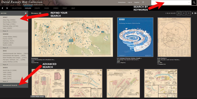
The Luna Viewer: How to browse & search the maps
In the main menu under View Collection select the Luna Viewer. Under Luna Viewer click the Launch Luna Viewer button.
The Luna Viewer at David Rumsey Map Collection
Tips for keyword searching:
In most cases it helps to start with a fairly broad search to see the full range of available maps
Be cautious with abbreviations. “MN” does not return “Minn” or “Minnestota”.
Advance search provides you with the use of full Boolean operators like “and,” “or,” “greater than,” “contains,” and others.
After a search, to return to the full collection, click on “show all” under the search button.
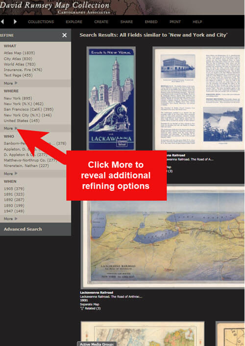
Let’s look at an example of using the keyword search in tandem with the Refine column. If you search for New York City, you will be searching all of the data associated with the maps. Since many maps may have been published in New York City, you will likely see many maps for other areas. You can improve this search by going to the Refine column and under Where clicking on New York City.
The Refine column will show you the first five options in each category (What, Where, Who, When). Click More to reveal all of the additional refining options in that category.
Click More to see all refining options in the Luna Viewer
From the returned results, click a map to view it.
You can select multiple items in the Refine column to filter more narrowly. Remove a filter by clicking it under Remove at the top of the Refine column.
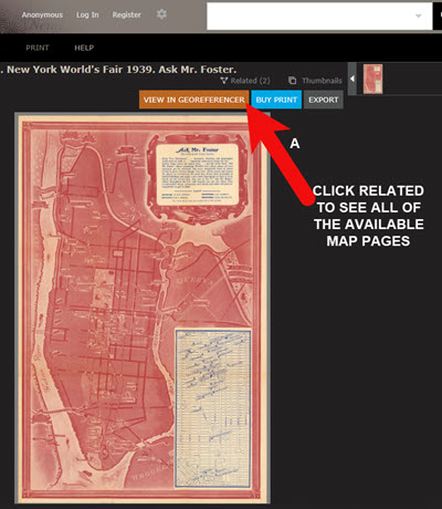
Like genealogical records, old maps may include several pages. Look above the blue BUY PRINT button to see the number of Related maps. In my example of a map of the 1939 World’s Fair in New York City, there were two map pages available. Click Related to display all of the available pages.
Click the Related link to view all related map pages.
DavidRumsey.com Advanced Search
The Advanced Search feature can be found in two locations:
Inside the search box – click your mouse in the box and select Advanced Search from the drop-down list
At the bottom of the Refine column on the left side of the screen.
Advanced Search gives you more control over how you search. Let’s look at an example by searching for Sanborn fire insurance maps.
Searching for Sanborn Fire Insurance Maps
The David Rumsey Map Collection website includes many Sanborn Fire Insurance maps. These maps were created for insurance purposes and provide an incredible amount of detail about individual buildings and dwellings in a given neighborhood.
I recommend using the Advanced Search feature to search for these maps. This is because over the years the name of the company as publisher changed.
How to Find Sanborn Maps:
Click on Advanced Search at the bottom of the Refine column
In the “find all of these words” section, click Fields and select Publisher
Type in Sanborn
On the results page, go to the Refine column and Who click More
There are at least six variations of the Sanborn publishing name.
Old Map books and atlases often include valuable historical text often called historical sketches. You can find these using the Advanced search. Search for the exact phrase Historical Sketch. Run this search and then in the Refine column under Where select an area of interest.
How to Download Maps from DavidRumsey.com
Click the map from the results list
On the map’s dedicated page click the EXPORT button at the top of the page.
Select the appropriate size from the drop-down list. (Larger maps may take a few moments to download)
Typically the maps will download to the Downloads folder on your computer
Tips for Selecting Download (Export) Map Size: Save space on your computer and future headaches by selecting the correct size map for your use. If you plan on using the map to create an overlay or create a nice large print, select the largest size possible ( I recommend at least Extra Large for creating map overlays in the Google Earth.) This will ensure that the map doesn’t appear fuzzy when you Zoom in. High-resolution is also recommended when printing. For example, if you plan on including the map in a book about your family’s history (for personal use, not for resale) a high-resolution map will print crisp and clear. Maps for use on the web or something like a PowerPoint presentation would be fine at lower resolutions.
MapRank Search at DavidRumsey.com
The MapRank Search “app” at the David Rumsey Map Collection website allows you to browse & search 6000 maps by two important criteria: Time & Place.
There are two ways to find the MapRank Search:
In the main menu under View Collection click MapRank Search. Scroll to the bottom of the page and click the Launch MapRank Search
Scroll to the bottom of the home page until you see Featured App – MapRank Search, and click the Launch MapRank Search
How to Find Maps Using MapRank Search:
Start with entering the location name in the search box (in the upper right corner) and click the Find a Place
The location will appear on the modern-day map. The old maps that match the location will appear in the column on the right, prioritized starting with the map that most closely matches what you searched.
Below the modern-day map, move the time slider levers to narrow in on the desired time frame.
Note that the old maps in the results column will change based on the specified time frame.
Broaden the location if desired by zooming out a bit on the modern-day map. Note that the results list will change as you zoom.
Hover your mouse over a map in the results list and notice that a reddish-brown box will appear the selected map and will also appear on the modern-day map. This indicates the area of the map that the old map covers. This will aid you in selecting the map that will suit your needs.
Click a map from the results list and it will open in a new browser tab, although some maps will appear as an overlay on the modern-day map. In that case, click the Luna Viewer button to go to the page where the map can be downloaded.
How to Compare Modern-day Maps with Old Maps
Whether you have found the map by searching with the Luna Viewer or the MapRank Search you will eventually find yourself on the page where the single map is displayed. On the left is the source information.
In the upper right corner of the screen click the View in GeoReferencer button. You will be taken to a page where you can view the old map overlayed on the modern-day map. In the upper right corner move the slider to make the old map transparent so that you can compare between the two maps.
Recap: Comparing the Two Best Search Tools at DavidRumsey.com
Luna Viewer: – 100,000 maps
– Search, then refine
– Sometimes glitchy interface
MapRank Search: – 6000+ maps
– More control with time slider & map
– Map results list ranked by closest coverage
Live Chat Q&A: Answers to Your Questions About David Rumsey Maps
One of the advantages of tuning into the live broadcast of each Elevenses with Lisa show is participating in the Live Chat and asking your questions.
From Megan: What is the difference between Google Earth and My Maps? From Lisa: Google Earth is a free software download. This is where I create what I call family history tours. They are a collection of data points and media that come together as a research tool and storytelling tool. My Maps are created in Google Maps. I prefer creating in Google Earth because it offers more tools and options, and it’s where I keep all my mapping work.
From Gwynn: Heard in the past Java Client might have security holes has this been fixed? From Lisa: Read more about the latest on Java Client at the website’s FAQ page.
From GeneBuds: Must set up account to use Luna Viewer? From Lisa: No, you don’t have to have an account to use the Luna Viewer. “Registering for an account allows you to save your work and preferences, search external media, create Media Groups and Presentations, customize your settings, create annotations, and upload your own content.” As I mentioned in the video, I prefer to do all my work in Google Earth.
From Gwynn: Sanborn Fire Maps: Where do I find the Key to the symbols? Are they the same from year to year or do they change? From Lisa: Here’s the main resource page for Sanborn maps at the Library of Congress. You will find specific information about interpreting the maps including Keys and Colors here.
From Karen: If you are specifically looking for plat maps for our US farmers would you put the word plat in the search field? From Lisa: I would use the Advanced Search and enter the word plat in the “Find all these words” box. Click the plus sign to add an additional “Find all these words” field and type in the name of the location. If that doesn’t deliver the desired result, omit the location and just search on the word plant. Then, on the results page, go to the Refine column and under Where click More. Then you have a nice list to browse. You might spot a map that includes your location. TIP: When you find a result, be sure to check the Related number at the top of the page so that you didn’t miss any additional pages of the map.
From Mark: Lisa and Bill, is the intro music something that you all wrote? From Lisa and Bill: No, it’s by a talented musician named Dan Lebowitz. Our goal this year was to learn to play it ourselves 🙂 We’re glad you love it as much as we do!
Join me for Elevenses with Lisa, the online video series where we take a break, visit and learn about genealogy and family history. (scroll down to watch the video)
Genealogy Consultation Provides a Strong Hypothesis
My 45-minute consultation with a genealogy expert Kate Eakman at Legacy Tree Genealogists broke things wide open on my Irish family lines and gave me the information and resources I needed to make all of the progress I shared in this episode. It’s the best investment I’ve made in my genealogy in a long time. They have experts in all areas. Learn more about how easy it is to book a consultation here.
After my consultation I needed to update my research plan and get to work collecting more genealogical evidence.
Let’s quickly recap what happened when I started working on my brick wall last week in episode 18:
Margaret Lynch’s death certificate said her parents were James Scully and Bridget Madigan.
Her obituary said she was born in Limerick Ireland.
There was one couple by those names in Limerick, having children and the right time. There is a gap in the records where Margaret should be.
Her husband Michael Lynch dies in Stillwater MN. St. Michael’s Catholic church. Found their marriage record in Stillwater. It was a large booming town, and a good place to focus. The Lynch family had a farm across the river in Farmington, Wisconsin.
My research question: Was this couple we found, James Scully and Bridget Madigan, who married in Kilcolman, Limerick, Ireland in 1830, the parents of Margaret Scully?
What Kate Eakman of Legacy Tree Genealogists helped me do in my 45-minute consultation:
Become acquainted with a variety of excellent Irish research websites
Located the indexed marriage record for James and Bridget
Located the original marriage record for James and Bridget
Located the indexed baptismal records for all of the children who had James and Bridget listed as their parents.
A Genealogy Research Plan for Collecting Evidence
After the consultation I developed a new research question: Are the children that we found records for in Ireland the siblings of my Margaret Lynch?
My research plan included:
Verify if there were any other couples by the names James Scully and Bridget Madigan married in Ireland, particularly in the time from of circa 1830. (Location of source: RootsIreland.ie)
Search in the U.S., starting in the area where Margaret lived, for each child. I’m looking for records that name these same parents, and show the child at an age that correlates with the baptismal date.
I identified several sources I believed would help me accomplish my goals.
Marriage Records – I conducted a search for James in Bridget in all counties in Ireland. I discovered that the couple Kate found during my consultation is the only couple in the RootsIreland database with those names married in Ireland. This gives me more confidence that I have the correct couple.
U.S. Records – Armed with the names and ages of the children of James and Bridget, it was time to return to America. I needed to search U.S. records to see if any of the children came to America (perhaps living near Margaret) and if these parents were named.
Records to look for:
U.S. Federal Census (Ancestry, FamilySearch), and State Census (Minnesota Historical Society, Ancestry, FamilySearch)
Death records (Minnesota Historical Society, FamilySearch.)
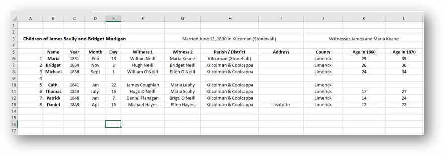
Before I began my search I created an excel spreadsheet to capture the information. I included columns for what their ages should be in each census.
Using a spreadsheet to track my findings.
Now I was ready to start the genealogical hunt!
U.S. Census
Search each sibling one at a time in the census.
Focus on Washington Co., Minnesota (marriage and death location for Margaret & Michael Lynch)
Move on to Polk County Wisconsin, and greater Wisconsin.
Search both U.S. Federal Census & State Census
Top locations identified for this search: Ancestry.com, Familysearch.org, Minnesota Historical Society
Results:
Found individuals matching the sons in Stillwater and Baytown (Washington County)
Found Bridget Scully (Mother) living with various sons in various census records.
Immigration years listed for some of Margaret’s siblings.
Found in the 1870 U.S. Federal Census: James, Thomas, Daniel and Bridget.
I created folders for each sibling marked MAYBE and collected the records on my hard drive.
Learn more about hard drive organization in Elevenses with Lisaepisode 8.
Searched FamilySearch and the Minnesota Historical Society for a death record for each son.
Found Thomas and James.
James Scully and Bridget Madigan listed as parents
Ages matched
Next step: order the death certificates
Newspapers
Next I searched the Minnesota Historical Society website for newspapers.
Results:
170+ articles
Two obituaries for Bridget Scully! (8 children, immigration year, husband died in Ireland implied)
Found James Scully working with his brother and his obituary
Research Tip: Look at a map and identify nearby towns and larger cities. Expand your search to these areas.
I found a James Scully in the 1860 census with Bridget and his brothers, and working with Thomas in many newspaper articles.
Bridget’s obituary said she came to America with 8 children. 7 had baptismal records in Ireland. James and Margaret were not found in the baptismal records but were confirmed in U.S. records to have the same parents. That would be a total of 9 children. It’s possible one of the daughters that have not yet been found in U.S. records may have died in Ireland prior to their leaving for America.
I then combed back through my Lynch binder – I might spot something that I marked as unsure, or that might jump out at me now that didn’t 20 years ago.
Found History of the St. Croix Valley I had photocopied a section. Names Daniel Scully (who I have since found in the census, newspapers and death records) and says his parents are James Scully and Bridget Madigan!
Looked the book up in Google Books. It’s fully digitized. Now I can extensively read and search it.
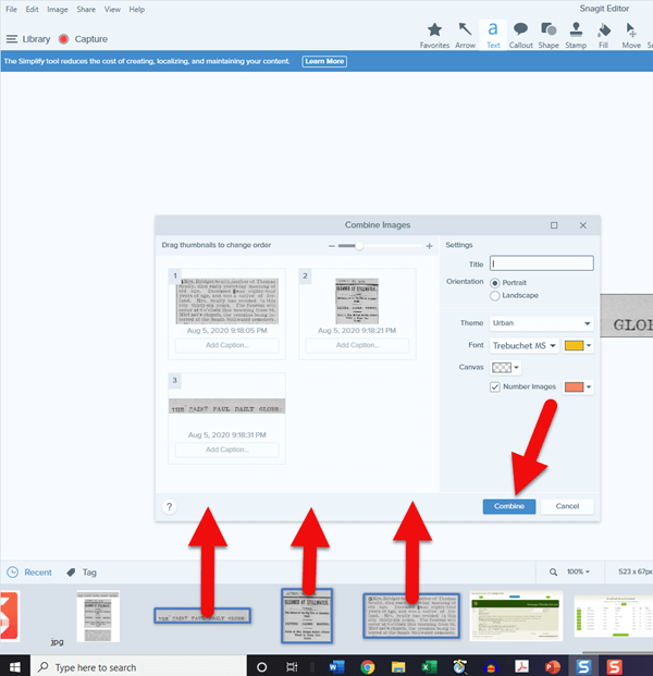
Tech Tip: Clip and combine newspaper clippings with SnagIt software
Clipping and saving newspapers poses a unique challenge for genealogists:
Clipping a small portion of a very large digital newspaper page can result in a low resolution file.
If you clip an article you don’t always capture which newspaper and issue it came from
Articles often continue in different locations on the page or pages, making it impossible to capture the entire article in one image.
I use SnagIt software to clip my newspaper finds. I can then save them to Evernote or archive them on my hard drive. SnagIt can save your clippings in wide range of file types and can even clip video. You can get your copy of SnagIt here. It’s a one time fee and download – no subscription! (Thank you for using my link – it financially supports this free without any added expense to you.)
How to combine multiple clippings with Snagit:
Clip the paper title and date
Clip the article
Clip any additional applicable sections of the article
In the SnagIt menu under Image click Combine Images
Drag and drop the clippings into the desired order
Click the Combine button
Save the combined image: In the menu File > Save As (you can select from a wide variety of file types)
Research Tip: Using Street Addresses in Google Earth
When you find a street address, whether in a newspaper, city directory, census or other genealogical record, use it to find the location in the free Google Earth software program. You can then save an HD quality image of the location.
How to find a location in Google Earth (on a computer):
Type the address into the search field in the upper left corner
Click the Search button
The map will automatically “fly to” the location and a pin will mark the general spot.
Hover your mouse pointer in the upper right corner of the to reveal the navigation tools. Click the plus sign to zoom in closer.
How to view the location with Street View:
Zoom in relatively close so that the street and buildings are distinctly visible.
Just above the zoom tool you will find the Street View icon (the yellow “peg man”). Click on the icon and drag it over the street in front of the building / location. Don’t release your mouse. It may take a second or two for the blue line to appear indicating that Street View is available in that location. If no blue line appears street view is not available.
When the blue line is visible, drop the Street View icon directly onto the blue line in front of the location you want to view. by releasing your mouse. If you miss the line and the picture looks distorted, click the Exit button in the upper right corner and try again.
Once on Street View, you can use your keyboard arrow keys to navigate. You can also click on further down the street to move forward that direction.
How to save an image of a street view location:
Position yourself in the best view of the desired location using your mouse and keyboard arrow keys as described above.
In the toolbar at the top of the screen, click the Image icon (it looks like a portrait-oriented page, near the printer icon)
A Title and Description box will appear at the top of the screen beneath the toolbar. Click it and type in a title and description for your image if desired.
You can adjust the size (resolution) of the image you will be saving by clicking the Resolution button above the title box.
When you’re ready to save the image to your hard drive, click the Save Image
Learn more about using Google Earth for genealogy in Elevenses with Lisaepisode 12.
Order the video training series at the Genealogy Gems Store featuring 14 exclusive step-by-step video tutorials. The perfect companion to the book The Genealogists’s Google Toolbox by Lisa Louise Cooke.
After a week of post-consultation research:
Question: Who were the parents of Margaret Scully born in Limerick Ireland on approximately July 9, 1840?
Answer: James Scully and Bridget Madigan, married in Limerick, Ireland June 13, 1830. (Though I feel confident about this, I still have additional records I want to find in order to further solidify this conclusion.)
Question: In what Parish was Margaret Lynch born?
Answer: Most likely Kilcolman based on the baptismal locations of her siblings.
My Next Research Steps:
Browse search through the baptismal parish records at NLI 1839-1842 for Margaret, and 1834-1836 for James Scully.
Look for marriages of Margaret’s female siblings, and family burials.
(Contact St. Michael’s church, Stillwater, MN.)
Go through newspapers.com – there are several Minneapolis and St. Paul papers running articles from Stillwater.
Resume my search of passenger list records with the newly revised date of c. 1851.
Search for the death record of Bridget’s husband James at RootsIreland and NLI.
How to Book a Genealogy Consultation
My 45-minute consultation with a genealogy expert Kate Eakman at Legacy Tree Genealogists broke things wide open on my Irish family lines and gave me the information and resources I needed to make all of the progress I shared in this episode. It’s the best investment I’ve made in my genealogy in a long time. They have experts in all areas. Learn more about how easy it is to book a consultation here.
Learn More:
For more step-by-step instructions for using Google Earth read my book The Genealogist’s Google Toolbox available at the Genealogy Gems Store.
Recommended Genealogy Gems Premium Member Videos with downloadable handouts: