Original air date: 10/8/20 Join me for Elevenses with Lisa, the online video series where we take a break, visit and learn about genealogy and family history.
In this episode we’re going to take many of the things we’ve learned in past episode of Elevenses with Lisa and apply them to one of your genealogical problems. My goal isn’t to find the answer myself, but rather to provide a toolbox of strategies that you can use to experience the joy of the discovery yourself when researching a home or location, as well as in a wide variety of other genealogical situations! Keep reading for notes that accompany this episode.
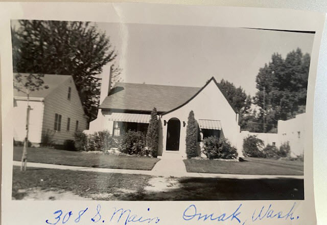
Cynthia Owens is a regular viewer and participant in the Live chat each week during Elevenses with Lisa. She emailed this photo and wrote “This picture was with my mother’s belongings…photo of a house in Omak, Okanogan, Washington with only an address written on it. 308 S. Main, Omak, WA. I have hundreds of photo’s (B & W) that have no information on them and a lot of people who I don’t know. I have a gold mine and no idea how to mine it.”
The house photo in Cynthia’s family collection.
Cynthia said that so far she has found the names of the last two owners in county records and some directories. She also determined that the house was built in 1928. She writes, “I have a lot of family on both sides of my parents who could have owned it.”
Formulate Your Research Question
The research question in this case boils down to: Who owned the home at 308 S. Main, Omak, WA in the 1930s?
Compile Known Family Names
We start by compiling a list of family surnames that we will be on the lookout for. These are families who are known to have lived in Washington state during that time frame.
Cynthia’s mother’s family names:
Woodhead
Patience
Cynthia’s father’s family names:
Tucker
Stubbs
Tonks
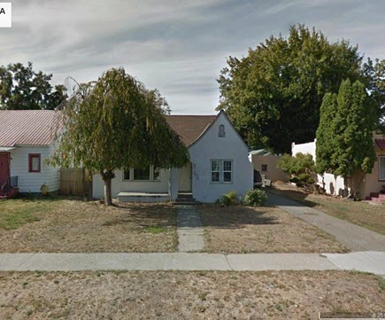
Answer the Question Does the house still exist today?
To answer this question, we turn to the free Google Earth Pro software. By simply searching the for the address and using Street View we are able to determine that yes, it is. Google Earth also allows us to obtain a high-quality image.
The house in Google Earth’s Street View today.
Google for Land Records
I conducted a simple Google search: Okanogan County Land Records
The results:
The Central Regional Branch of the Washington State Archives
“The Central Regional Branch provides archival and records management services to local government agencies throughout Benton, Chelan, Douglas, Franklin, Grant, Kittitas, Klickitat, Okanogan, and Yakima counties.”
Special Guest: Kathy Nielsen, Librarian Kathy Nielsen is a reference librarian and an educator. She has a masters degree in History and in Library Science. Kathy is currently a popular genealogy speaker on California’s Monterey Peninsula. She incorporates her skills as an historian, a storyteller and a librarian in her search for her family’s history. Kathy Nielsen stopped by to offer suggestions on obtaining land records. Watch Elevenses with Lisa episode 20 on House History featuring Kathy Nielsen.
The FamilySearch Wiki
Visit the free FamilySearch Wiki here. Search for the county in the wiki and then click on Land Records.
County Auditors Department
Where land records are located.
You can do a title search.
The records may not be online.
Email or call and inquire what the options are to access the records or have a search done.
Access varies by county.
Follow the chain of ownership back in time:
Grantee = the person who bought the property
Grantor = the person who sold the property.
Real Estate Websites
Trulia.com
Zillow.com
These sites don’t provide owner names but do show you recent transactions.
Result: The house was sold in 1997. It went on the market briefly in 2013.
Assessor’s Office (Tax Records)
These are typically only available to the current owner.
More Places to Look for Real Estate Related Information
City Directories
City directories are usually published yearly. Look also for Reverse Directories that allow you to look up the address in order to find who lived there. Kathy suggests contacting the local public library staff to inquire about City Directories and other records. Many libraries are currently staffing online reference chat.
State Libraries
Kathy recommends expanding out from the local area library to nearby communities, and the state. The Washington State Library is also currently answering questions. They have a genealogy department and city directories.
WorldCat.org
WorldCat is the world’s largest network of library content and services. The online catalog that itemizes the collections of 17,900 libraries in 123 countries and territories.
National Register of Historic Places
According to the website: “The National Register of Historic Places is the official list of the Nation’s historic places worthy of preservation. Authorized by the National Historic Preservation Act of 1966, the National Park Service’s National Register of Historic Places is part of a national program to coordinate and support public and private efforts to identify, evaluate, and protect America’s historic and archeological resource.” Click here to learn more about and search their digital database.
Department of Archaeology and Historic Preservation (Washington State)
From the website: “On this site you will find information on historic buildings, the archaeology of Washington State, how to navigate our regulatory processes and how to nominate properties to the State and National Register of Historic Places.”
Neighbors
Contacting and talking to neighbors is often one of the quickest and easiest ways to gain information. The 411.com website offers a free reverse address lookup. The results will give you the name of the current owner and residents, and even plot nearby neighbors (with names) on a map.
Researching the Home from Home
If you’re unable to research in person, make significant headway with these online resources.
Historical Societies
Google to find the official website of the historical society located in the area where the house is located. These sites may include searchable databases and information on how to contact them for resources and lookups.
Result: The Okanogan County Historical Society features a searchable database.
Facebook
Search Facebook for the name of the county historical society in the area where the house is located. Facebook pages often include more up to date information than the official website.
Old Maps
Depending on the town and area, you may be able to find an old map from the approximate time frame that includes details on homes. Two excellent free resources are:
Davidrumsey.com
Historical maps in the Layers panel of Google Earth Pro
Search at Genealogy Records Websites
Searching for various combinations of the address, town and surnames from the family tree may lead you to an answer. Here are a few examples of searches run at Ancestry.com and FamilySearch. (Your results may vary depending on the date you are searching):
Keyword: (address) 308 Main St, Omak (exact)
Results: 25 (These were not all exact)
Residence: (town) Omak (exact) and Keyword: (address) 308 Main St. (exact)
Results: 5
Search each surname in Okanogan County at Ancestry.
Results for Cynthia’s mother’s family names:
Woodhead (Paul Woodhead married in Okanogan in 1941)
Patience (No results)
Cynthia’s father’s family names:
Stubbs (results from the 1970s)
Tonks (None)
Tucker (8 results)
FamilySearch.org
Run the same at the free FamilySearch.org genealogy website. Search each surname with Omak (exact) & 1920-1940 (restricted to) U.S. On the day I searched, the only surname from the list with results was Tucker. Cynthia’s next step would be to compare the results to her known family tree.
Search the Census Specifically
You can search the census by using the search fields and using variations of names, town, county and specific address. If you don’t find the specific address that way, brown the records of the town, looking for addresses written in the left margin. At Ancestry, look for the link to a map of the location found in a census.
Results: 1930 Census: 104 West First St., Omak (Jess Tucker)
Use Google Earth to determine if the addresses found are the same today. Plot each finding on the map using placemarks.
Result: 1930 Census Address: 104 West First Street, Omak = not there today
A search in the 1940 for Jess Tucker found him still living with his mother. She was recorded as “Frances Write” living at 504 Main St., Omak, close to the house in question. When searching the census be sure to look at the pages on either side of the results page. In this case Jess is found on the next page living at “no number” as a renter at his mother’s home.
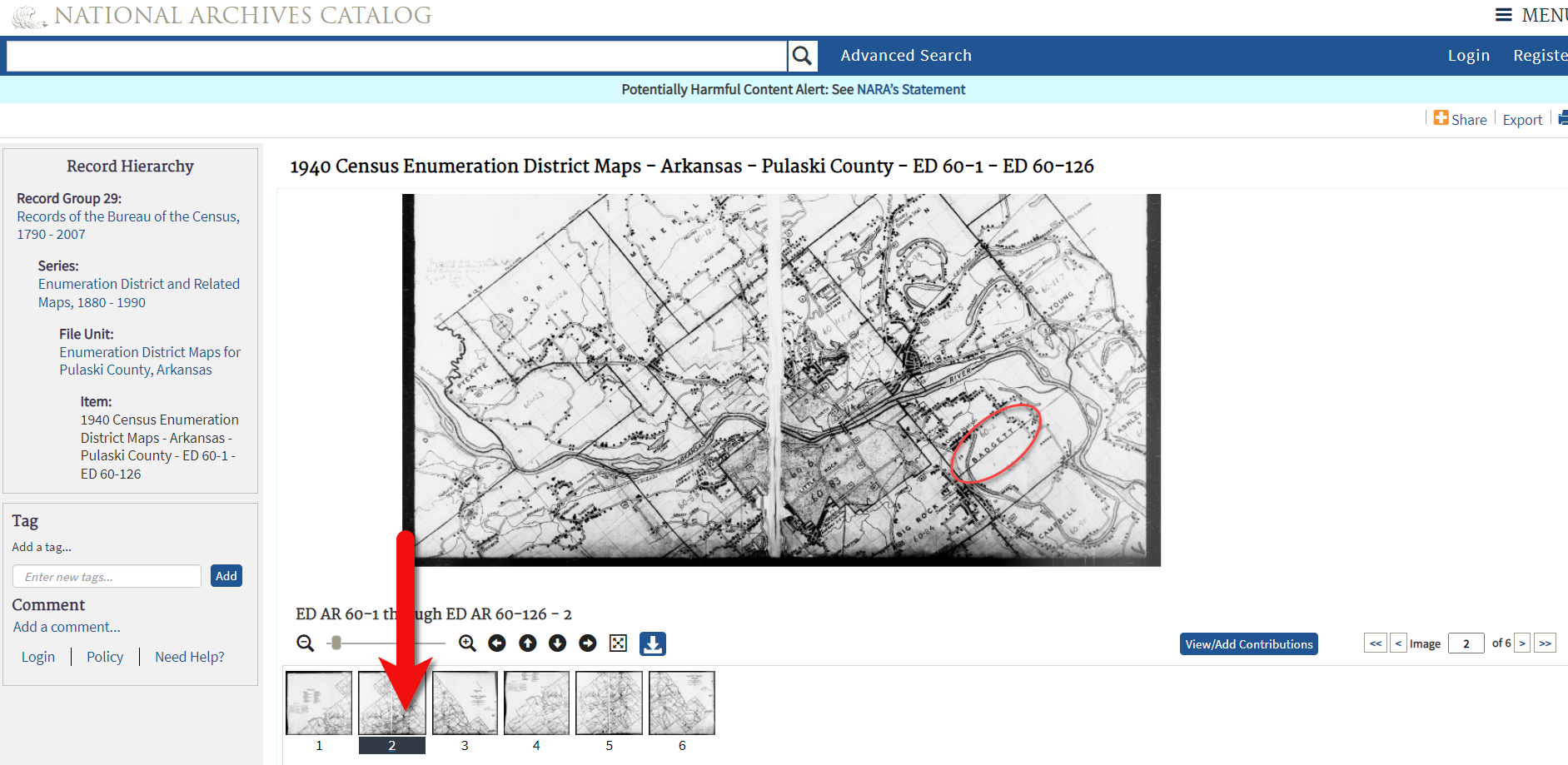
1940 Census Enumeration District Maps
Ancestry has a collection of 1940 Enumeration District Maps from the National Archives (where they can also be found here along with additional helpful search strategies.) Enumeration districts are geographic areas that were designed to allow an enumerator (the census taker) to visit every house in the district within a two-week time period. A month was allowed in more wide-spread rural areas. These maps vary in the amount of detail provided. They may or may not indicate house numbers.
Go the Ancestry Card Catalog and search for the 1940 Census Enumeration District Maps collection. In the search fields for this collection, enter the enumeration district number which can be found in the upper corner of the 1940 census page.
State Census
State Censuses were often conducted every ten years in years ending with “5” which makes them a great supplement to the U.S. Federal Census. They also sometimes include information not gathered at the federal level. Therefore, an important question to ask is “was a State Census taken in this approximate time period?”
Here’s a State Census list from the National Archives.
Results for Washington state: No state census taken after 1898.
Card Catalog Include Useful Unique Sources
Not all useful records will surface with a straight-forward search. Dig into the Card Catalog of your favorite genealogy records website to find unique and useful collections that may include addresses.
Example: Search the Ancestry card catalog for Okanogan County, WA Found: Washington, Postmaster Indexes, Prior to 1965 Strategy: Browse the alphabetically organized Okanogan cards for each family name.
Another unique record type that often includes address are Draft Cards. Search by location then surname. Also try Keyword searches. Not all cards include complete addresses but many do.
The Future is Bright
Here’s a summary of the wide variety of genealogical research strategies we’ve covered in this episode:
I really want to hear from you. Did you enjoy this episode? Do you have a question? Please leave a comment on the video page at YouTube or call and leave a voice mail at (925) 272-4021 and I just may answer it on the show!
If you enjoyed this show and learned something new, will you please share it with your friends? Thank you for your support!
Elevenses with Lisa is our little slice of heaven where friends get together for tea and talk about the thing that never fails to put a smile on our face: Genealogy!
The National Archives is a wonderful resource of unique genealogical records. Though the archives are closed, the website is open, and it’s a great place to search for records and prepare for future genealogy research trips.
The National Archives website and online catalog can be a bit mystifying. If you’ve ever tried to search it and wound up frustrated, you’re not alone. This is often the case because the nature of the archives and the search function of the online Catalog are not genealogically focused. Armed with an understanding of how and why it is set up the way it is, and the know-how to search, refine, and download documents, you’ll be ready to add it to your genealogy toolkit.
In this video episode and article, we’ll be answering important questions such as:
What kind of genealogy records can be found at the National Archives website?
Which genealogy records are not available at the National Archives?
How do I search for records at the National Archives online Catalog?
How can I retrieve only digital items from the National Archives Catalog?
How can I get better search results in the National Archives Online Catalog?
How do I download files from the National Archives Website?
What Kind of Records Can be Found at the National Archives Website?
To understand the types of records we can expect to find we must first understand the role and mission of the National Archives. Their role is preserving and making available only the permanent Federal Government records. Some have genealogical value.
These records are arranged as the agencies created them, so there is no master subject or name index.
While they have 110 million + digitized pages in the Catalog, this represents just a small fraction of the holdings.
The Catalog contains descriptions for their nationwide holdings in the Washington, DC area, regional facilities, and Presidential Libraries.
The Catalog currently contains descriptions for 95% of the records, described at the “series” level.
You can find basic information about the records, including size and location, from the catalog description.
The National Archives is regularly adding more file unit and item descriptions, many of which include digital files.
Some traditional genealogy records can be found at the National Archives such as:
Census Records
Passenger Arrival Records (Immigration)
Land Records
Military Personnel Records
Court records
Fugitive slave cases
Naturalization records
Federal employees
Applications for enrollment in Native American tribes
Most if these records are available in person. However, all National Archives locations have been closed since March 13, 2020 and remain so as of this writing.
Genealogy Records You Will Not Find at the National Archives
Because the following genealogy records are not created at the federal level, they would not be cataloged or found at the National Archives:
Birth
Marriage
Divorce
Death records
Deeds and wills.
To obtain these records, check with the appropriate state or county.
What to do before you search the National Archives Catalog online
Before you begin your online search:
Write down your research question.
Decide what topic you want to browse.
Think of possible ways your ancestor interacted with the Federal Government.
On the National Archives website they provide a great example of a research question that a genealogist might have and how it can lead to records.
QUESTION: Why did my ancestor have a significant decrease in net worth between the 1860 Census and 1870 Census?|
ASK YOURSELF: How might your ancestor have interacted with the federal government that could help explain this discrepancy?
RECORDS TO SEARCH FOR: The Bankruptcy Act of 1867 allowed many people to file for voluntary bankruptcy. The genealogists could search in the National Archives Catalog for bankruptcy AND [state where you ancestor lived during that timeframe] to see if bankruptcy records are available that could help answer the question.
How to Search the National Archives Catalog Online
There are three key types of searches you can conduct in the catalog:
Keyword searches
Filtered searches
Advanced search
Let’s start with a keyword search:
Go to https://catalog.archives.gov
Enter keywords in the search box in the center of the page.
(If you are looking for an exact phrase using two or more words, put them in quotation marks example: “bounty land”)
Press the magnifying glass button to run your search.
The results will be returned starting with best results at the top.
To view a description, click on the blue title.
You can use the filters on the left side of the results page to narrow down your results.
Refine your search results by type if you know the type of material you want. Example of material type include photos, maps, or textual records.
It’s important to remember that just because the item appears in the result does not mean that it is available online. Many of the descriptions don’t include digital images of the records.
How can I retrieve only digital items from the National Archives Catalog?
You can dramatically narrow down your search results to include only digital items that you can review from home. To do this, on the search results page, click on the filter Archival Descriptions with Digital Objects. This will revise your results list so that you will only see descriptions of items with images attached.
How can I get better search results in the National Archives Online Catalog?
It never hurts to try searching by name, although many record descriptions will not name the people who are named in the records. You can improve these searches by using quotes around the entire name, or just the surname. This will restrict results to only items that exactly matches what appears in the quotes.
You’ll notice that there isn’t a specific search field for names in the National Archives Catalog. Here are several additional search strategies you can use when searching for the names of people:
Search on the person’s full name in first name-last name order.
Search for last name – first name within quotes
Search on the surname only. Again you can use quotes.
Search on spelling variations using the search operator OR. This works well when searching name variations such as: Burkett OR Burkette.
Search on variant spellings of the first name, including “Americanized” versions.
Example: Joseph Maggio OR Guiseppe Maggio.
Again, keep in mind that most descriptions in the National Archives Catalog do not include the names of people mentioned in the record. If you know an individual participated in event, search for related keywords and look within the records. You will need to read them to see if your ancestor is mentioned.
Another way to improve your search results is to shift your focus from people to topics. This is strongly recommended by the National Archives. You are much more likely to get a greater number of results because people aren’t usually named in descriptions. Be sure to read the description carefully to see if the item will be helpful and worth requesting.
When searching topics, think about and make a list of relevant phrases and keywords. For example, when searching for Land Records, try searching for phrases such as:
How to Download Files from the National Archives Website
After clicking the description on the search results page you will be on the record page. If there is a digital image, it can be downloaded. Look below to see if there are additional pages. You can click to select the desired page and then click the download icon just below the image.
If you would like to download all of the images, look below the list of images to see if a compiled PDF is available. This will allow you to download and save all of the images in one convenient file.
The Record Group Explorer at the National Archives Website
The Record Group Explorer offers a unique way of visualizing and finding records at the National Archives website:
Allows you to browse NARA’s holdings by Record Group
Use it to get a sense of the scale and organization of records
Explore what is available online via the Catalog
Provides an overview of the digital scans available online within a Record Group: textual records, photographs, maps and charts, electronic records, and more.
Records are grouped by specific government agencies. Each group is represented visually in a section. The section is light blue, signifying the total volume of textual records. If a dark blue bar appears in the section, it is an indicator that some of the records are digitized. The percentage or number (depending on the view you select in the grey Record Group Explorer Tools bar across the top) of digital images will be shown.
If the section is green, that indicates that there are records online but they are not textual records. They may be items like photographs or films.
If the section is grey, there are no records available online at all.
Click a section to learn more about that Record Group and explore the records.
Record Group Highlight: Motion Pictures
The National Archives holds a surprising number of motion pictures. As you browse or search, focusing on topic will likely be more helpful than searching by name. Consider looking for your ancestors’ homes, businesses, military service, events and associated locations.
“A series of films: 306-LSS, a group of more than 400 black and white reels of stock footage that ended up in the hands of the United States Information Agency (USIA).”
Answers to Live Chat Questions
One of the advantages of tuning into the live broadcast of each Elevenses with Lisa show is participating in the Live Chat and asking your questions.
From Sue M.: Do they hold WPA and CCC records? From Lisa: Yes to both!
From Steve S.: Can you use the * and ? as search operators in the NARA catalog? Also thanks for de-mystifying this site! you have made it much more understandable. From Lisa: After the show Steve did some searching and found this handy page providing additional search tips and operators supported by the website. Thanks Steve!
From Michael R.: Are the Naturalization records in the National Archives different from those in local courthouses? From Lisa: I haven’t looked lately, but about 15 years ago I filed a Freedom of Information Act (FOIA) request and received my great grandfather’s federal naturalization paperwork. It included a photograph that was not included at the county court level.
From Lynnette B.: I had my parent’s old home movies put on DVD’s several years ago. What is the next step in making them more available? Adobe spark video? YouTube? I want to identify each person on them? From Lisa: An easy way to get started is by making Adobe Spark Videos (see episode 16) which is free and easy. Use the Titles feature to add text explaining who is who. Uploading them to your free YouTube account channel is a super easy way to share them.
Resources
Get My Free Genealogy Gems Newsletter – click here.
Getting started on Ancestry.com can be a little daunting. As one of the world’s top genealogy websites, it’s packed with information about millions of people–perhaps including your ancestors. These step-by-step instructions will help you start...
Have you ever found an address for an ancestor but been disappointed that it is just a Route number and a town name? Have you wondered if it is possible to figure out where they actually lived? The good news is, it is! I’m going to show you how to take a rural “route” address from the early 20th century and find it on an old census enumeration district map.
(This article contains affiliate links for which we may be compensated. Thank you for supporting our free content.)
In a recent video I showed you how to find 1950 Census Enumeration District (ED) maps. These are super helpful and also free. In that video we used the address of an ancestor that we found by hunting through old letters and documents. But for many Americans in the early 20th century that address may have just been a route number and town.
That was the case for my viewer Lisa. She emailed me after she watched the video. She writes, “How can you find the E.D. number when you only have a Route number? My relatives lived in rural Arkansas.”
This is totally doable! Follow allow these steps of this case study and they will help you find the E.D. number and census enumeration district maps, and zero in on the location.
“Route 2” & Rural Delivery
A carrier route is basically the territory one letter carrier can cover on a daily basis. So, there could be a Route 1 or a Route 2 in thousands of places around the country. It just happens that your ancestor was on, say, Route 2 in a particular township area. Although it doesn’t tell us which house, it does dramatically narrow down the place because a daily route was the same and may not have been that large. Once we find that area we can then use other sources to help us try to get even more specific.
The first thing we need to do is gather some details. We need:
The ancestors’ names
The Route number address which includes the town
The county – which is something we can easily find online with a quick search
The year – in this case the address she has is from 1950.
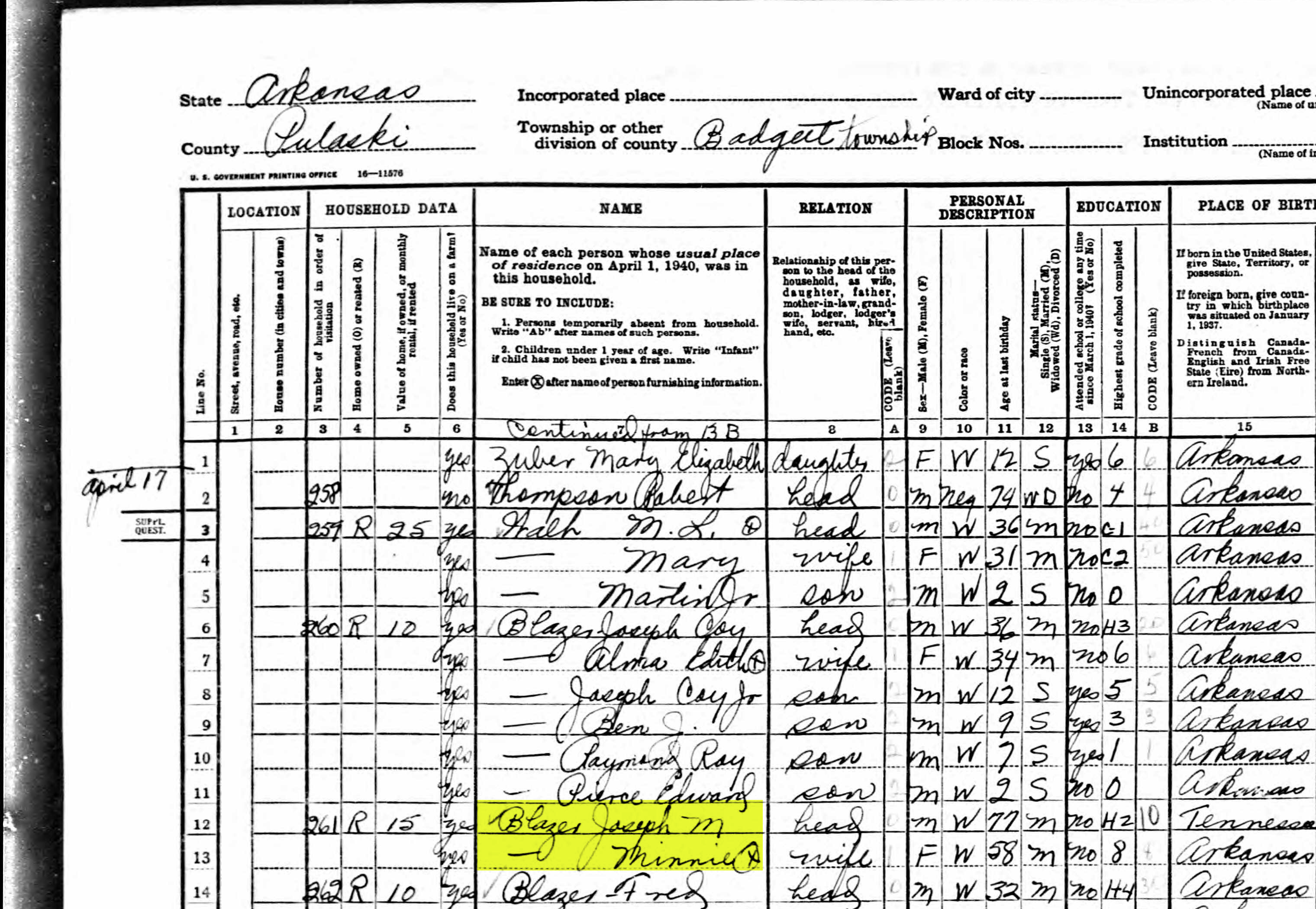
So, here’s what Lisa sent me about her ancestors, the Blazers:
Names: Joseph Madison Blazer and Minnie Blazer
Route number: Route 2
Address: Frazier Pike
County: Pulaski
Joe and Minnie Blazer c1950 (Image courtesy of Lisa Egner.)
Step 2: Find the Family in the Census
Now we need to find the family in the census record closest to the date of the known address.
Since the 1950 census hasn’t been released yet because I’m recording this in Jan. of 2022, we can’t yet pull up their record. So, we’ll need to turn to the 1940 census. There’s a good chance that the family was in the same location since folks didn’t typically move around quite as much or as far as we do these days.
The 1940 census is available for free at many of the larger genealogy websites like FamilySearch and Ancestry.
Here’s the Blazer family in the 1940 census, and Lisa confirmed that she believes this is the same place.
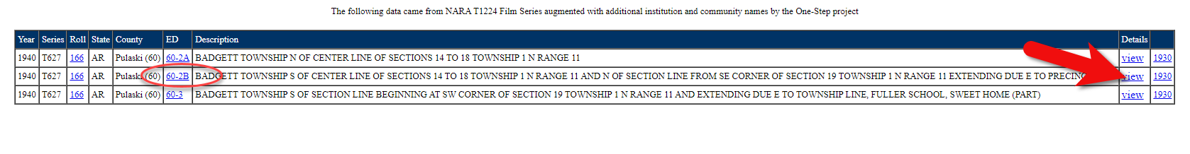
On the census record we are looking for three very important things:
the township (Badgett Township)
the ED number (60-2B)
and any address written along the left margin. If you don’t see anything, check the pages before and after that page. (Frazier Pike)
Step 3: Search for the Township
Once you have the location or township, search for them in an online map. I prefer to use Google Earth, but I often also use Google Maps. It doesn’t hurt to check both.
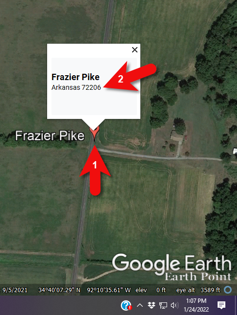
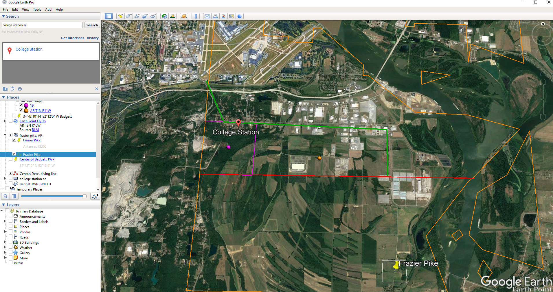
In this case we have two locations to look for: Badgett Township and Frazier Pike. We’ll start with the actual address which was Frazier Pike, Arkansas. Google Earth tell us that it’s a road just southeast of Little Rock, AR. When you click the pin it also tells you the current zip code for the Frazier Pike area, so we’ll make note of that. I’m like to create a project folder (Blazer Address) in my Places panel and then save the location pin in it. I will add additional items to the folder as I find them.
Click the pin to see the zip code.
Next, I’ll search for the other location found in the 1940 census, Badgett Township. It doesn’t appear in either Google Earth or Google Maps. That’s probably because it’s been renamed or incorporated. Googling may be able to help so I googled: badgett township arkansas history.
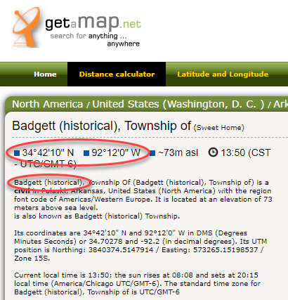
This led me to a website that provided several helpful clues. It says that Badgett is “historical”, meaning that it’s the old name of the town which has since changed. It also provides us with the latitude and longitude of Badgett which we can use in Google Earth to confirm it’s location.
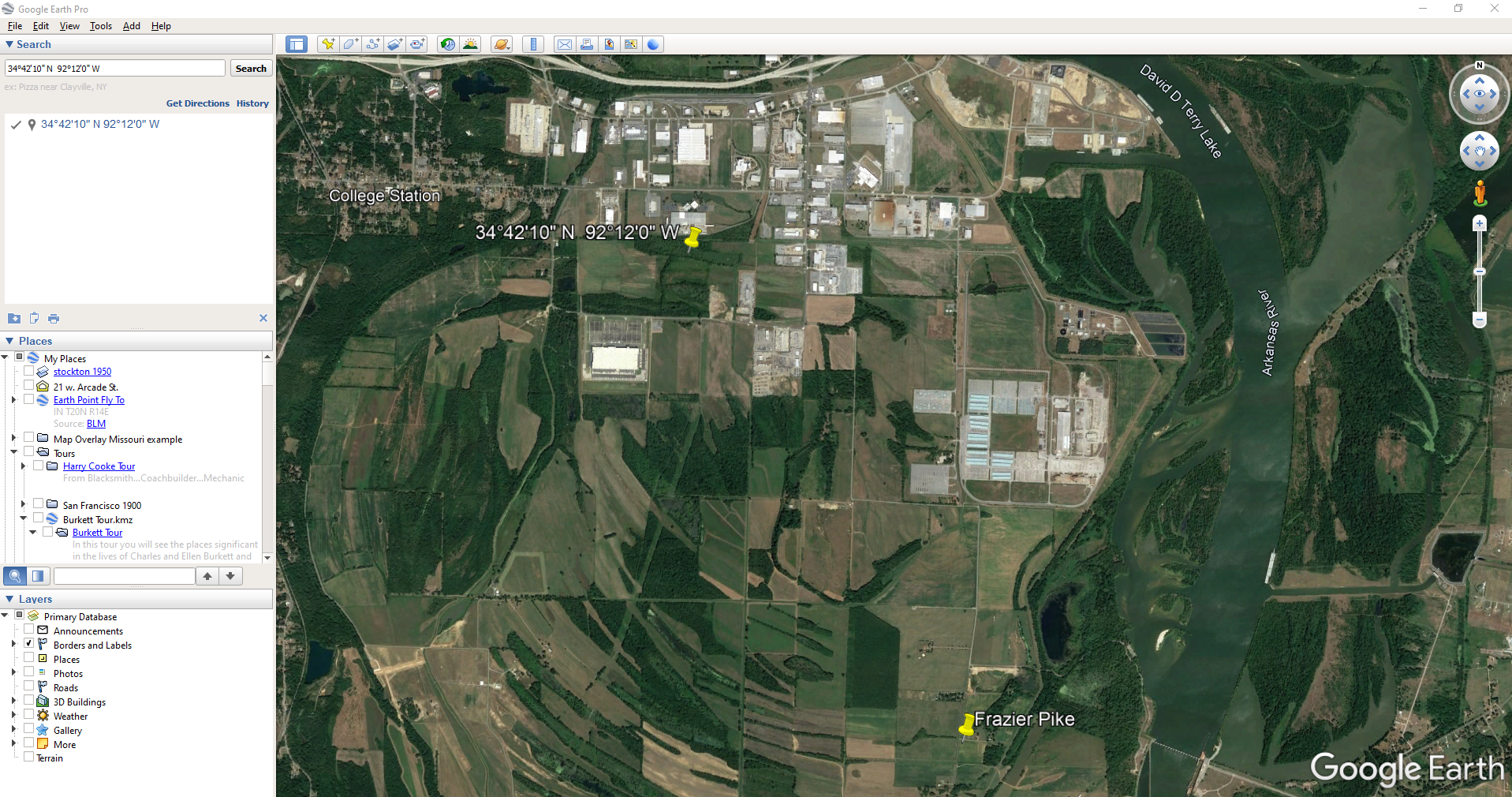
Go back to Google Earth and enter the coordinates (34°42’10” N 92°12’0″ W) in the search box and press ENTER on your keyboard.
The locations are very close.
And indeed, it’s very close to Frazier Pike. (image above)
I also like to look at the image results when googling. The website results are organized by the most relevant images. When I ran a search on Badgett, AR, and click Images on the results page, I see that the first one showed a map showing Frazier Pike. So, they are nearly one and the same.
Another search result was theHome Town Locator website. It says “the Township of Badgett (historical) is a cultural feature (civil) in Pulaski County. The primary coordinates for Township of Badgett (historical) places it within the AR 72206 ZIP Code delivery area.” This confirms that it is historical, the coordinates pin the same place on the map, and the current zip code is the same.
A quick Find on the page search (Alt + F) for Route 2 jumps me to a nice bit of history.
In the section discussing schoolhouses we get a description of the route: “…located in the main red-dirt road called Route 2 in Pulaski County. Route 2 is now known as Frazier Pike.”
Step 4: Find the ED Map for the Closest Census
Next, we turn our attention to the enumeration district or ED number we found on the 1940 census. As you’ll recall, 1940 is the closest available census record to the date of the address, and we found Lisa’s ancestors in that record in Badgett, AR which we now know is the Frazier Pike area in Pulaski county. On that record it says: Badgett Township. ED 60-2B.
We could google for the year of the census and the words enumeration district map. However, there’s a great free tool for finding them over at Steve Morse’s One-Step Tools website at stevemorse.org.
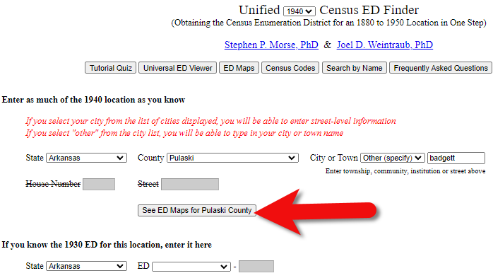
In the menu under U.S. Census select the Unified 1880-1950 Census ED Finder, select the year at the top of the page. In this case we will select 1940. Next, enter the state (Arkansas) and county (Pulaski). You can then select the city or town. However, in the case of rural addresses, don’t expect to find the town listed. If it offers you an “Other” option you can try and type the name of the town (Badgett) in the field provided. Don’t bother entering the route number (Route 2) because that’s not a street address, it’s a postal delivery address.
We could also run this same search on the 1950 census. Chances are you will see more ED numbers listed because the population was growing. Since an enumeration district had to be the size that one enumerator could cover in about a two week timeframe, they were often redivided as they decades went by.
Since we know from the 1940 census that township was in existence, we should receive a list of ED numbers as a result. In this case we got three: 60-2A, 60-2B. and 60-3.
Click the corresponding ED number.
Click the linked ED number that matches the one you found in the census record. In this case, the 1940 census record told us that the Blazer family was in ED 60-2B, so we click that link.
The next page lists each ED. Click the View link for the ED.
Click the View link.
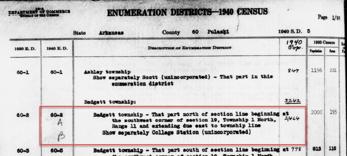
The View link will take you to the exact page for that ED in the ED Descriptions from the National Archives T1224 microfilm from Record Group 29. This description helps even further define the area.
1940 Census ED Description
60-2 A and B says, “Badgett Township – That part north of section line beginning at the southwest corner of section 19, Township 1 North, Range 11 and extending due east to township line. Show separately College Station (unincorporated.)”
This is perfect because its’ giving us the township, range and section! We can use this information to plot it in Google Earth.
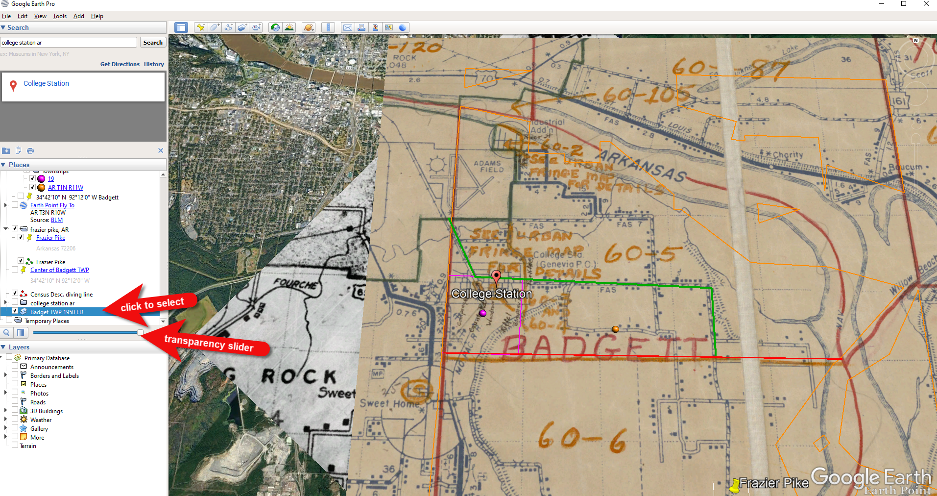
How to plot a land description in Google Earth with Earthpoint:
Enter the state, principal meridian (in this case there’s only one choice here thankfully), township, range and section numbers from the census description.
Click the Fly to on Google Earth button.
This may open automatically in Google Earth or you may be prompted to save the file to your computer. Do that and then click it to open. It is a KMZ file so it will automatically open in Google Earth.
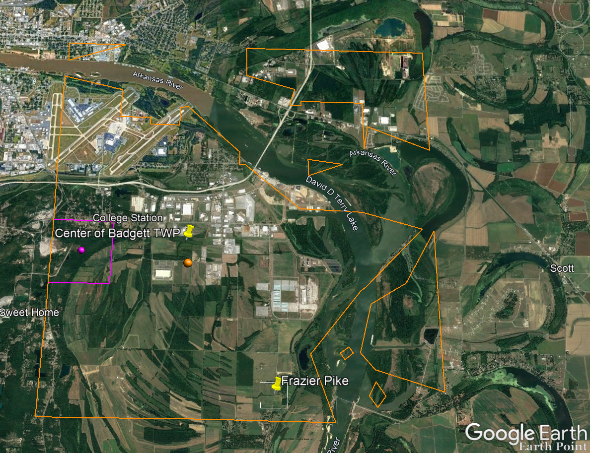
And here are the results! The location is mapped out for you.
Census description mapped in Google Earth.
Notice I still have my placemark pins for the approximate location of Frazier Pike, and the center of Badgett Twp which we got using the latitude and longitude coordinates. Section 19 is outlined in purple, and the township is outlined in orange.
Since Frazier Pike is a road, turn on Roads in the Layers panel. Now we can see that Frazier Pike is running north and south and our pin is right on top of it.
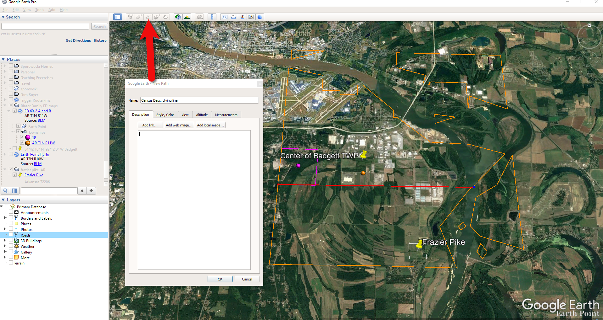
Now we can use the census description to further zero in on the area. “Badgett Township – That part north of section line beginning at the southwest corner of section 19 Township 1 North, Range 11 and extending due east to township line. Show separately College Station (unincorporated.)”
Mark that in Google Earth using the Path tool. Click the Path button in the toolbar at the top oof Google Earth. Click on the southwest corner of section 19 (outlined in purple) and then go east and click the township line (in orange.) Give your path a title and click OK.
Click the Path button in the tool bar.
Next in the census description, on the same line as “B” it says “Show separately College Station (unincorporated.)” We can find College Park by searching for College Station, AR in the Google Earth search box.
Next, we want to follow Frazier Pike going north until we are above the section line that started in the southwest corner of Section 19. Use the Path tool again to mark it on the map.
Use the path tool to draw lines in Google Earth.
Get the Enumeration District Map
Now it’s time to head back to Steve Morse’s website and get the ED map for 1940. On the page you started your search, click the See ED Maps for… button.
Click the See ED Maps button.
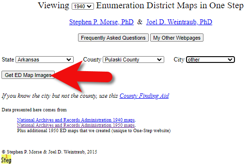
On the next page select the state, county and city again and click the Get ED Map Images button.
Click the Get ED Map Images button.
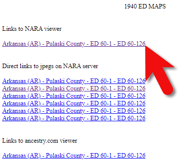
This will take you to a list of all of the available maps. The first link will take you to the National Archives webpage where you can look through all the maps for the area you selected. You could also look through all the individual maps by clicking each of the links listed under “Direct links to jpegs on NARA server”. However, I don’t recommend that will take longer because they are extremely large image files. It’s easier to quickly look through them on the NARA website.
Click the Link to NARA viewer.
Click the link to the NARA viewer and look for the township name in the map thumbnail images. In this case I’m looking for Badgett. You can do this quickly by clicking each image and then drag the larger map in the viewer around with your mouse. I found Badgett Township in the second map.
Map images at NARA.
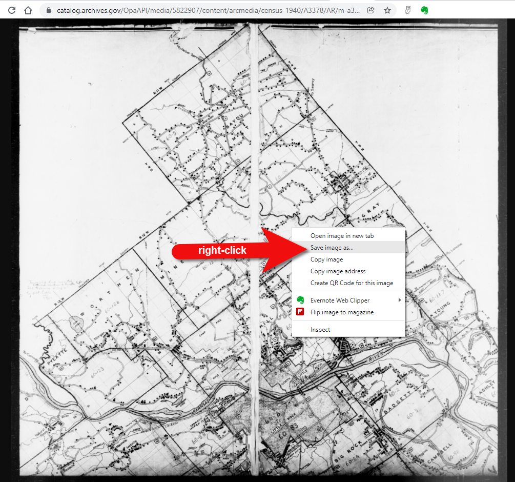
Download the full-sized map by selecting the thumbnail image and then clicking the download button (down arrow.) The full resolution map will load in your web browser. Right-click on it and Save Image As to save it to your computer.
Right-click on the map to save it to your computer.
It can help to create a map overlay in Google Earth using this map. (Learn how to do this in the newest edition of my book The Genealogist’s Google Toolbox.) I cropped the image to just include Badgett Twp.
In fact, you can overlay both the 1940 and 1950 ED maps. Click to select a map in the Places panel and then you can use the transparency slide to fade it to reveal changes.
Select the map and use the opacity slider in Google Earth.
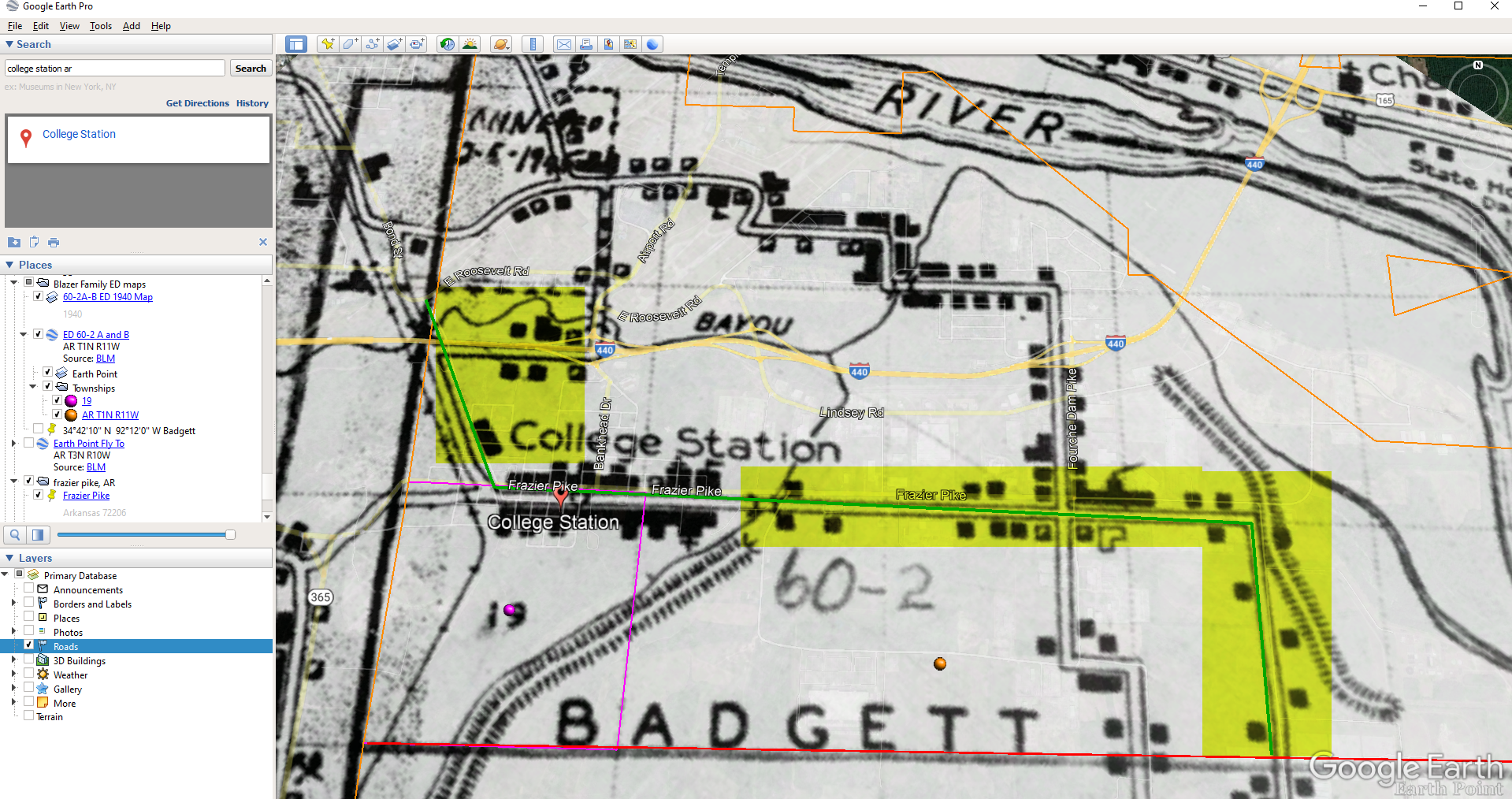
Step 5: Follow the Census
The census can provide even more clues about where in an enumeration district an address was located. Using the census record and the census description of the enumeration district, it can help to highlight the area of the map. In this case, ED 60-2 is “that part north of section line” which I marked with a red path line. The Blazers address was Frazier Pike (which I marked with a green line), so this eliminated the northern area and the Fourche Dam Pike road. To make sure that I could eliminate that area, I verified in the 1940 census that Fourche Dam Pike was enumerated separately by running a keyword search of the Pulaski County census records at Ancestry. And yes, indeed folks living along Fourche Dam Pike were enumerated separately and the road was written along the margin just as Frazier Pike was. This gives me a lot of confidence that I’m identifying the right area.
The route highlighted on the census ED map.
As you can see, there are little black squares and other markings on the map. To find out what each of those means we can turn back to the National Archives and download the page from this map collection that includes the map key.
The black squares are “Farm Units”. A farm unit square is not one family , it is the entire farm, including the owner and other families who may live and work on the farm. We also see businesses, churches, the town hall, school houses and more. We may not be able to find the exact home, but it’s possible to get very close. To do that, we need to head back to the census records themselves.
On Ancestry.com , the Blazers appear on Image 27. The filmstrip makes it easy to quickly scan through the images and browse them.
In this case, there are about 33 images or pages in ED 60-2B. The enumerator would start at one end of Frazier Pike and then make her way to the other. The enumerator wrote “College Station Pike” on pages 1 and 2. That isn’t a road today, and I couldn’t find any references to with a quick search. However, all of the other pages say, “Frazier Pike”. My guess would be that the census taker started on the west side – the hub of College Pike – and made her way east. Census enumerators visited homes and farms in a logical path, although they may have criss-crossed back and forth across the road. They listed the order in which they visited on the census form itself. In cities we might also see house numbers listed, but that’s not the case in a rural area. However, you may see pencil dots with visitation numbers written on the ED map. They were instructed to do this in rural areas in the census enumerator instructions in 1940. Unfortunately, the person enumerating 60-2B did not.
We could also look at the types of businesses and buildings shown on the map, and then look through the census records at occupations. We see a “factory/industrial” building to the east so we would look for people working in that environment in the census and see where they are living. We see a denser population in College Station along with a schoolhouse and two churches, so it would be worth looking through the census pages to see where the school teacher and pastors are listed. Folks may not have lived on the premises, but it would make sense they lived near their work.
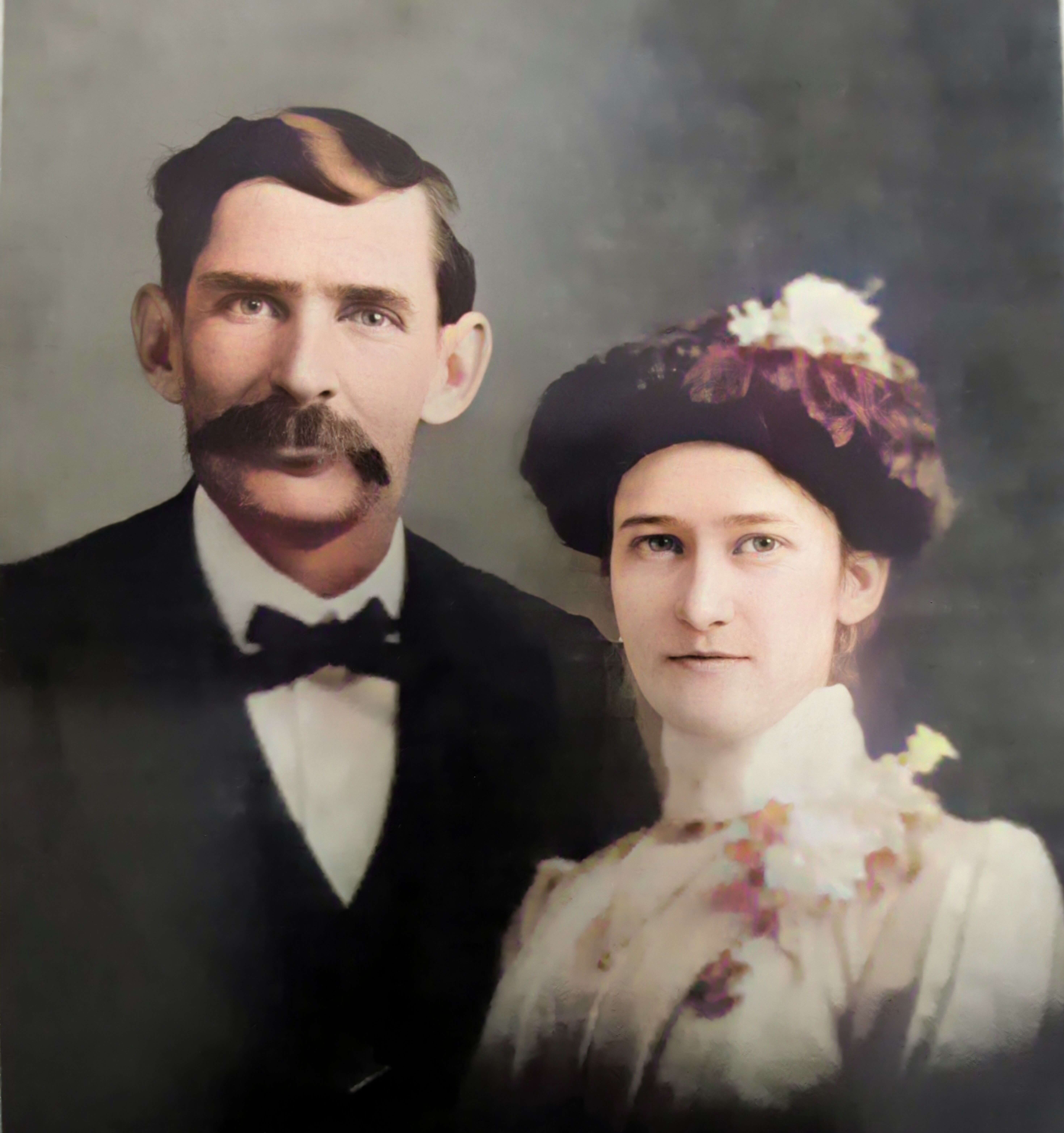
Wedding photo Joseph Madison Blazer Minnie Mae Peters (courtesy of Lisa Egner)
And finally, we want to look for renters and owners. If a family rented, a capital “R” was entered on the census. Those who owned their property were listed with a capital “O”. Since the black squares are “Farm Units” we wouldn’t expect to see a square on the map for every house. If our hypothesis is that the enumerator started on the west side, we could count the number of owned dwellings listed in the census until we get to the family living in question. Then we would count them on the map, going east. Again, it’s not exact, but it’s a whole lot more than what we knew about the address Route 2 Frazier Pike when we started!