VIDEO & SHOW NOTES: Video #5 of our 25 Websites for Genealogy YouTube Playlist. In this video, my guest presenter Gena Philibert-Ortega covers Library and Archive websites that are must-haves for family history research. You’ll find plenty of genealogy gems waiting for free at websites #23 through 25 in our list.
Websites 23 through 25 of our 25 Websites for Genealogy
Some of these websites will be new to you, and others are going to be very familiar to you. In talking about the familiar websites, I want to get you thinking about them differently, explain a little bit more about what you can do at these websites, and how to get the most out of them.
In this series of 25 Websites for Genealogy, we’re going to be looking at websites in different categories. Our third category is Library and Archive websites (#23 through 25).
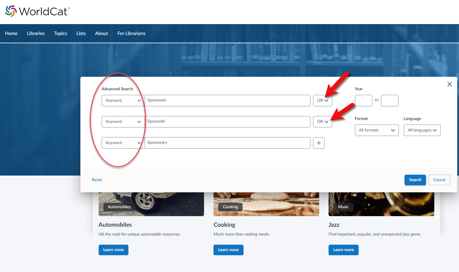
WorldCat.org is a free website that provides access through its card catalog to millions of materials from libraries around the world. You’ll find items such as:
United States Civil War and other military records
Family Bibles, church histories, and records
Publications such as directories, handbooks, and magazines
Birth, marriage, death, wills, and obituary indexes
Microfilmed genealogy and local history collections
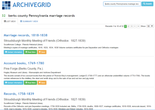
This lesser-known free website can help you locate old documents and manuscript items available in over 1,500 different archival collections. ArchiveGrid currently includes close to 5 million archival item entries!
ArchiveGrid is a companion website to WorldCat, the free online catalog of millions of library items from thousands of libraries. The difference is that ArchiveGrid focuses not on published items but (generally-speaking) on unpublished ones.
The National Archives website and online catalog can be a bit mystifying. If you’ve ever tried to search it and wound up frustrated, you’re not alone. This is often the case because the nature of the archives and the search function of the online Catalog are not genealogically focused. Armed with an understanding of how and why it is set up the way it is, and the know-how to search, refine, and download documents, you’ll be ready to add it to your genealogy toolkit.
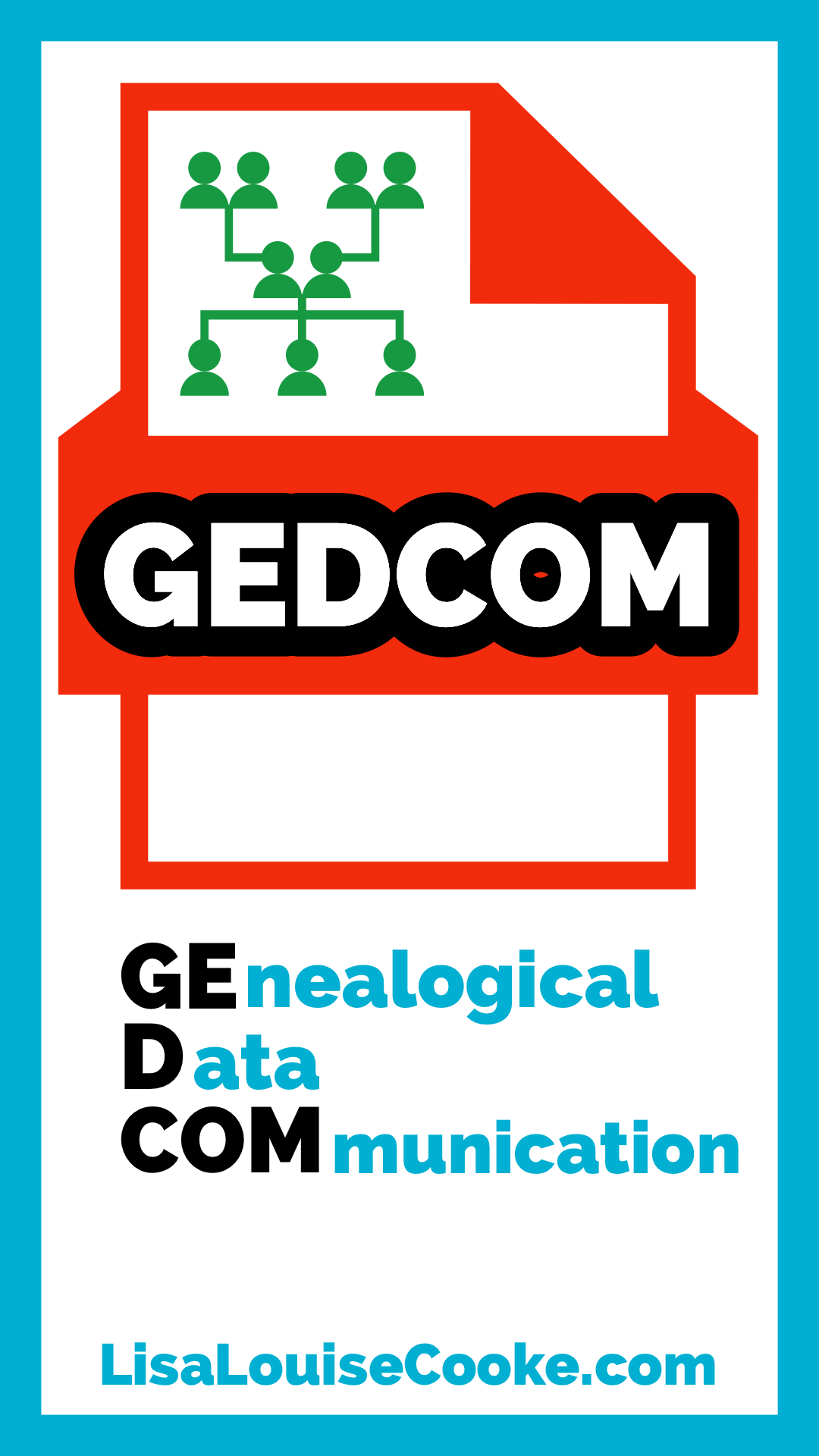
The GEDCOM digital file format is essential to genealogy. My expert guest from FamilySearch explains what a GEDCOM is, how to use it, and the most recent changes. He’ll also answer some of the most common GEDCOM questions.
Show Notes
If you’ve been watching my videos for a while, then you probably know that I really recommend that you have a complete copy of your family tree on your own computer. But what if you’ve been building your family tree totally online up to this point?
The good news is that you can export your family tree as a GEDCOM file. But what exactly is a GEDCOM file?
Gordon Clarke, the GEDCOM Developer Relations Manager at the free genealogy website FamilySearch.org joins me to answer that question and provide the latest information about the GEDCOM.
What is a GEDCOM?
(00:54) Lisa: What is a GEDCOM?
(01:14) Gordon: GEDCOM is actually an acronym for:
GEnealogical Data COMmunication.
It’s a type of file with specific rules that allows digital family history products to exchange information. It’s been around so long that all the software companies can read and export it.
Say for example that you have a particular family tree program you’ve been working in but there are some features in another application that you like to try out. You want to try it out with a computer file that the program can read. All of the popular genealogy programs allows you to write a GEDCOM file and then you can read it in and review your information and add to it. That is what a GEDCOM is for.
It’s a specific file type that was works with most family history applications. It’s a text-based file, though it has special constraints to it. It was designed to be easily adaptable and compatible with importing and exporting. So, as long as the developers of both products adhere to GEDCOM specifications, you shouldn’t have a trouble downloading from one and uploading to the other.
Lisa: It sounds like each genealogy software database and website probably have their own proprietary file type, right? So, this is one everybody sort of agrees on that can extract the genealogy data set right. Is that right?
Gordon: Right, and there are differences between the proprietary program and GEDCOM. There are some products out there that only support GEDCOM. So that’s their proprietary format.
Why Use a GEDCOM?
(03:45) Lisa: So why should we use one a GEDCOM. When would we find ourselves wishing we had this universal file?
Gordon: Family history is more of a record keeping whether it’s photos and stories and genealogical data. People like to keep it and have control over it. So, GEDCOM is I like the word “personal”. You can personally control it. It’s just a .GED file, so any operating system can handle copying and emailing it. So, for personal control, preservation and sharing of genealogical data. It’s the most universally accepted format.
I would think for your backup purposes because it’s so universal, make sure that the program that you’re using has the ability to save your data in GEDCOM. Then you can decide whether you put it in your thumb drive or removable drive or you put it up in the cloud, you can decide how to preserve it. Think of it more as your personal file over this important information.
(05:31) Lisa: I like that idea. I’m probably not alone in that I once had somebody give me a little floppy disk and it had the whole family tree that this person had been working on. Unfortunately, it was a proprietary file, and it was a program that no longer exists. I’m helpless to be able to use it. So, a GEDCOME can really solve that issue.
Do All Family Tree Programs Support GEDCOM?
(06:00) You kind of touched on this, but I just want to just double check. Can all family tree programs and websites export the GEDCOM? Are you familiar with anything that don’t?
Gordon: I would say all of the popular programs and websites make it possible to import GEDCOM, and most of them allow for exports. There are some exceptions to that rule. If you’re going to spend your time using a program, look to see if it’s GEDCOM compatible.
To help even more so standardize the industry, the software providers commit to implementing the newest version of GEDCOM. Much of that is backward compatible. We presented those that have or will be planning to implement the newest version of GEDCOM at Rootstech. You can search at Rootstech for “GEDCOM” and see the videos of what’s been rolled out and what’s coming.
Who Owns and Controls GEDCOM?
(07:41) Lisa: Is there one particular group or authority or somebody who’s in charge of deciding what the GEDCOM is and how it works? Or is that a role that FamilySearch is playing?
Gordon: It is a role that Family Search has been playing. FamilySearch is the software development, education marketing, support arm of the department called The Family History Department of The Church of Jesus Christ of Latter Day Saints. So sometimes because of marketing reasons, people think that we’re different. Family Search is totally run by the Church of Jesus Christ of Latter Day Saints.
From a historical standpoint, the original specification was created and released in 1984. All subsequent versions have been copyrighted by the Church of Jesus Christ of Latter Day Saints.
Now, in the last three years, as a like a product manager, I took on the responsibility for working on the new version, version 7 of GEDCOM. But it’s always been an effort of FamilySearch as the outreach arm for the Family History Department.
What we did differently in this last version is we solicited all the key players and software companies. It was much more of a collaborative effort to go through the changes, things to keep, things to just get rid of. It took about two years working with many people. Now the version is what is called a public GitHub repository. As we worked toward version 7, it was to prepare it for a starting point. The decision process is still a steering committee sponsored by FamilySearch, but the input and the communication on changes is open to all software developers. You can learn about all that because it’s hosted at GEDCOM.io. So GEDCOME.info is kind of like the general public, and GEDCOM.io is more for technical software developers.
GEDCOM Features
(10:38) Lisa: What are some of the features of GEDCOM 7? What are some of the things that you consider when you’re continuing to develop the GEDCOM?
Gordon: The process that we worked on was, I think to eliminate ambiguity, there could be different software providers that would interpret the file specifications a little bit differently. We wanted to clean up the specifications so that there would be much more, not 100%, but a much better compatibility between the people that were reading it and writing it. So, we worked very tediously on eliminating the ambiguity.
I would think that the biggest thing is, it’s become more of a storage format of photos, and records and data. Let me read something, “FamilySearch GEDCOM version 7 incorporates the added ability to include photos, and other files when users download a FamilySearch GEDCOM 7 file from a supportive family tree product.”
Your local photos can be bundled in a special file that we called GEDZIP. It’s a GEDCOM file that is a zip package. That means that anybody that unzips that package will get the GEDCOM file and all the external files associated with it and have everything be readable. It’s a packaging technique to put everything together, which really adds to this idea of a personal preservation and sharing. Now you can package everything together and preserve it and share everything that’s important to you with others.
In addition to this zipped packaging capability, notes have been expanded for more versatile use and styling of text. When you add notes, whether it’s a relationship or a location, you can actually stylize those notes now and use bold and italic.
Many tools and sample files were created to help with self-testing. It’s based upon the Apache license, which is more of a technical slant on things, but to software developers, that means it’s an open software license. There’s a public GitHub repository that you go to github.com/familysearch so that you can request and watch ongoing changes in a more of a public environment, though Family Search is still the stewards and has the final say on decisions.
So that’s what’s new. It’s more open to the public. It’s been cleaned up with some important new features.
But backward compatibility for 90% of the GEDCOMs that are out there (and the last one was 5.5.1) is still possible. But it won’t go back to 3.0, 2.0. That’s where that’s where some of the incompatibilities are, is because people are using versions that are 20 years old. And things have changed a lot in the last 25 years. We have a clean, fresh start, and a new community working on continuous improvements. But there won’t be changes because the standards shouldn’t change much. This new version 7 is going to be pretty much the same for a while everybody gets on board.
Do GEDCOMs Include Image Files of Attached Records?
(15:21) Lisa: You mentioned photographs. Would that include image files? Would that include if we downloaded an image of a genealogical record which might be a .JPEG file? Would those come along with the GEDCOM?
Gordon: Yes, absolutely. All the elements of GEDCOM have definition of how to use them. And what’s called the multimedia link, the multimedia link means you can link to local files, JPEGs, PDFs, you know, whatever they are. And if you don’t want to put it all together, you can link to files that are in the cloud, and it will remember where they are. If you package them together in a GEDZIP file, and then you unpackage it, you’ll be able to access the local image files and the local records there.
So, this idea of putting it all together, I mean, bandwidth is much better than it used to be. But still, for people that have hundreds of thousands of images. This is not the best format for that. So they can work out a strategy taking into account the cloud service they use, and which photos they will keep locally on their computer. So, they can keep track of everything, both in the cloud and on their local drive. And that can all be referenced in this new version of GEDCOM.
Is There Data Loss When Exporting a GEDCOM?
(16:59) Lisa: Excellent.
So one of the questions I’ve heard from people is that they are concerned about loss data loss. If they’re importing or exporting, maybe going back and forth, is there a chance that you’re going to lose things or even introduce an error of some type?
Gordon: This is kind of the issue of the work on version 7. One of the biggest issues is not only new features, but to get a new standard to kind of clean the slate. If you get stuff into the new GEDCOM version 7 the likelihood of data losses is greatly reduced. So, we’re encouraging the adoption and use of GEDCOM 7 because it’s less likely to cause any data loss or errors.
Family Search and industry experts have worked for two years to remove ambiguities, simplify the definitions and samples in order to eliminate the possibility of data loss and errors when transferring between programs. In the long run, not only does it include more media, but the whole goal is to improve the consistency, the compatibility and minimize or even eliminate data loss. So, what you will start being seeing is the question “is GEDCOM 7 compatible?” Because GEDCOM 7, when we were working on something that was 20 years old, is going to be more compatible in the future. We have a body to watch out for it. Your data will migrate to the new version without data loss. But looking at down the road, staying with the version 7 or higher will assure a sure better preservation of what you have.
Learn More About GEDCOM at Rootstech
(19:17) Lisa: I think you mentioned or alluded to that there were some announcements at Rootstech 2022.
Gordon: Yes, go to the sessions and type in “GEDCOM” and you will get three opportunities. One is a session called GEDCOM 7 Launched and Rolling Strong. Another session will be FamilySearch GEDCOM 7 What’s Next? And the answer is teamwork.
There’s two pre-recorded videos about the What’s New in GEDCOM 7 and then how the industry’s going to join together in working on it in the future. In in one of the sessions, the first one, there actually is a slide that shows all the companies that have committed to it. But all the majority of the companies have said, both in the cloud and desktop and laptop, and some have said when they’re going to release it. And one company I think, is announcing their release at Rootstech of the new GEDCOM version 7.
Future Updates and Changes to GEDCOM
(20:44) Lisa: That’s great to see. Anything I didn’t ask you or that you think people should really be aware of as they move forwarding and keeping up to date with GEDCOM 7?
Gordon: Again, with a standard, we don’t want to change too much too fast, because they wanted to get solid as a new transfer format.
I think the big areas that we’re working on for future versions is related quite a bit to internationalization. There are probably 20 different calendaring systems that are different than what we do in the U.S. To be able to respect those different calendars and to understand the translation between calendars is a big part of internationalizing GEDCOM.
The other part related to that is that there are some places in the world where how they define relationships between people is not typical to either the US or Western Europe. And so we are working on major upgrades and encourage people to come join with us. With naming conventions we may think given name, surname, but in reality, there’s other relationships that get into the name. If we even go to Africa their name is the first name may go back 10 generations, so their name is a memorization of all those names. So, improving on names is an important effort, the structure and relationships.
Another improvement is places. We think hierarchal and certain jurisdictions, but over time, and in different areas of the world, how you organize places is different. We need to address that in the GEDCOM specification.
Sources and Citations need to be upgraded for the genealogical community. And so, we certainly invite not only software developers, but genealogists to join our effort to improve sources and citations.
GEDCOM Hypothesis
One thing I’m really excited about is that we have a team that’s been working a year, and they’re probably working on it another year or two, on what we call hypothesis. This is so that you can share information without claiming it as a conclusion, and keep it separate from a conclusion. This encourages collaboration. So instead of arguing about I’m right, you’re wrong, we call it a hypothesis. Then we can have a discussion until there’s enough sources to prove it. This Hypothesis module I think is going to be really exciting. But that won’t be for a couple years or so until we actually release it.
Lisa: I think that’s a terrific idea because so often we are just battling with ourselves over what we think the answer is, and we want to track it while we’re doing it.
I’m curious: sometimes we go to a website, and you have to pick what language you speak. Perhaps if you’re searching for videos on YouTube you might say English. Is this something being considered? Is the goal no matter what that it’s only one type of file that serves every country or was there a consideration that you could select your country and then the GEDCOM would support your calendar and your geographic areas. I’m sure that was a discussion.
Gordon: Oh, absolutely. And, but what you’re talking about, just to be clear, is the specification to give all of the options and more to the software developer. The software developer can decide the language of the interface, and many of them are already doing this. So the actual presentation, if it’s Norwegian, or Danish, or whatever, it’s different according to the language that you place. What we’re looking according to your language of choice is that the orientations are names, relationships, and places jurisdictions, will be easy for the software developer to switch to by just changing that.
When we look at an international – how people look at information – it may be a different lens that they look through. So having the ability to give the software developers out of our future specs, to switch their interface, and switch around because they might be working in one part of the country because of their heritage, and then they might work in another and to be switched between it and to still have the data be the same, regardless of what national lens they’re looking through.
Lisa: It’s amazing that one little package contains so much and so much flexibility. That’s really terrific.
The Team Working on GEDCOM 7
(26:52) Gordon: I won’t drop names but in my immediate steering committee, that we meet with weekly, not only do I have three representations from within FamilySearch, but from the community, I like to call them doctors, they are doctors, they have their PhDs in computer science. Some are genealogists, they have their peers, one is even a linguistic professor. Another is an actual legal professional. It’s been wonderful to work with such experts, really, that are reasonable, and want to make things easy for the software developer. So, it’s quite a dilemma, instead of just making it right in the specification, but we’ve got to make it right and make it easier for the software developers to implement it. So that’s my thanks to all the people I’ve been able to work with.
16 million Americans answered the call to serve their country during World War II and tragically over 400,000 never returned home. To honor them, each family of a fallen hero received a banner with a gold star to hang in their window. Now 80 years later, there’s another way to ensure they are honored and most importantly, not forgotten. Today the nonprofit Stories Behind the Stars focuses on researching and writing the stories of every one of the WWII fallen. In this special Veteran’s Day episode of Elevenses with Lisa, Don Milne, founder of Stories Behind the Stars joins me to discuss the project, how to access the stories, and how you can help with the research that ensures that every single one of the World War II fallen are remembered.
(Get your ad-free Show Notes Cheat Sheet at the bottom of this page in the Resources section.) This article includes affiliate links. We will be compensated when you use our links at no additional charge to you. Thank you for supporting our free content!
16 million Americans answered the call to serve their country during World War II and tragically over 400,000 never returned home. To honor them, each family of a fallen hero received a banner with a gold star to hang in their window. Now 80 years later, there’s another way to ensure they are honored and most importantly, not forgotten.
Today the nonprofit Stories Behind the Stars focuses on researching and writing the stories of every one of the 421,000 US World War II fallen. I want to share with you how to find them, and how you can help with the research that ensures that every single one of the World War II fallen are remembered.
The Stories Behind the Stars founder Don Milne joins me in this video episode. He’s a lifelong history buff, and a few years ago he decided to write a daily story about one of the US World War II fallen for his blog called WW2 Fallen 100. His effort totaled more than 1,200 stories and has been read more than 1 ½ million times.
After his banking job was eliminated at the end of 2019, Don decided to devote his full time to create Stories Behind the Stars and find volunteers to write the stories of everyone of the 421,000 US World War II fallen.
The Story of a Fallen Hero of WWII
Lisa: I’d love to start by putting the fallen heroes of World War II front and center. Can you share with us one of the stories that has really touched you?
Don: Yes. It’s harder and harder to do that because so far we’ve already done about 13,000 stories. One of the more recent ones that we’ve done on our Pearl Harbor project was a fellow named Don Whitestone. He was on the USS Arizona, the battleship totally decimated at Pearl Harbor. More than 1000 people were killed on that ship, and he was one of those. If you go to the USS Arizona Memorial, you just see a name on the wall. And that’s basically all you know about him.
USS Arizona (public domain)
So, for our project that we’re focusing on right now, is to tell the story of all the men lost at Pearl Harbor, all 2335 of them. We’ve already finished the one for Don Boydston.
Just to give you a little bit of information about him. We know he was from Fort Worth, Texas. He was the youngest of six children. Almost every one of his brothers also enrolled in the military during World War Two. His eldest brother survived the war. His second oldest brother, he was actually in Hawaii the same time as his younger brother. Don was there while he was on shore. So, he would have probably been looking for his brother right after the attack, and wouldn’t have found him because he didn’t survive and they never found his body. He ended up continuing in the military and rose to the rank of Lieutenant Colonel. And he received the Silver Star for leading his men against the Germans in France in 1944. He died in 1945 while the war was still going on.
Another brother by the name of Robert served as a lieutenant. He was wounded, but he survived the war and lived to be age 90.
Another brother by the name of Ward, he joined the Army Air Forces. He was on a mission to Tripoli in 1943, in his B24 Liberator, and his plane went down.
So, here’s a family of five brothers. Two of them survived the war, and three of them didn’t. One of them died the very first day of the war, Pearl Harbor, and one of them died during the very last year of the war. It must have been devastating to have a family of five sons and lose three of them. But the father of the family, he did something really interesting. He decided that he was going to write stories, to write letters to the servicemen that may not be getting letters, because back then there wasn’t any social media. You couldn’t pick up a cell phone and talk to people. You had to write letters. And that was like, the thing that all of the servicemen looked forward to is they wanted to get letters from home. And so he made it a project in 1942. He was going to write stories to servicemen who didn’t have someone writing to them. He wasn’t going to be able to write to his son Don because he died at Pearl Harbor. But rather than feel sorry for himself and live with that loss, he decided to write the letters for a long period throughout the war.
He started with 137 different soldiers that he wrote to on a regular basis. So, I think that’s a wonderful thing that I didn’t know about. And all of these men and women who didn’t come home from World War II deserve to be remembered by more than just seeing a name on a memorial or gravesite. So, there’s a lot more Don Boydstuns out there. What we’re trying to do is find volunteers that can help us find those stories.
Lisa: That’s such a fitting story. That father was making sure that the soldiers weren’t being forgotten. You’re in a way, of course, carrying that on today, through your project. And, as you listen to that story, you realize that you think you’re hearing one person’s story. But I’m hearing the story of the parents. I’m thinking about the mom. I just can’t imagine all the sons going to war and losing one. And so really, you’re capturing the stories of many more than the 421,000 fallen.
Lisa: What’s the mission of the Stories Behind the Stars project?
Don: The name of the project kind of tells what we’re doing. It is what they still do today. During World War II when a family lost a serviceman or woman during the conflict, they were given a banner with a gold star on it that they could hang in the window. We want to tell the stories behind those stars.
We have the World War II Memorial in Washington, DC. Th Price of Freedom monument carries that same motif. It has more than 4,000 individual stars, each one representing 100 of the fallen.
Stories behind the stars, our mission is pretty ambitious. We want to make sure that all 421,000 servicemen and women Army, Air Force, Army, Air Force, Navy, Marines, Coast Guard, Merchant Marines, every single one of them will have a story.
Part of the mission isn’t just to have it on some obscure website somewhere. But we want to have it available so anyone can read it at the memorial. It’s got to be super easy to find on a smartphone. That’s our mission. And the only way we can accomplish this is we need volunteers that are genealogy minded, that want to want to do this and do something more than just bring flowers to remember someone on Memorial Day. We’re looking for folks to create a permanent record that will go forward for decades to remember them.
WWII Fallen Resources
The National Archives hosts the following casualty lists on their website:
MyHeritage: Stories Behind the Stars volunteers often use MyHeritage’s photo enhancement and colorization tools on the photos included in the stories, in addition to their genealogy records. Visit MyHeritage.
Up until June 2021, all of the stories our volunteers have been writing were saved directly to Fold3. In the case of the Pearl Harbor project, it was decided to first save these stories to theTogether We Servedplatform because it allows for some extra features not part of using Fold3. However, all TWS content is also shared over to Fold3.
Fold3 recently updated its user interface and this change did not include the automatic transfer of the stories from Together We Serve to Fold3. This is scheduled to happen by December 1, 2021. Once the update is complete, you will also be able to find stories like Don Boydstun’s story on Fold3.
The best place to search for all the completed Stories Behind the Stars stories is at the Stories Behind the Stars page at Fold3. Currently, the search only works for stories saved with the new Fold3 format. As previously mentioned, there are about 10,000 stories saved in the old format and Fold3 is converting those over.
The Pearl Harbor project webpage is still a work-in-progress, and writers are still working on the stories that have been researched. They have about 500 unassigned stories and anticipate a completion date of December 7. Until then, you can find stories at the D-Day page where there is a link that will take you to a page that separates the D-Day fallen by state. You will then find links showing a list of all D-Day fallen from each state.
Volunteer for Stories Behind the Stars
You can help Stories Behind the Stars reach their goal of completing all the stories by the 80th anniversary of the end of WWII in September 2025 by writing one story a week. Visit Stories Behind the Stars and click the Volunteer button.
They occasionally share sample stories on their blog, as well as their podcast. This will help you get the idea of what these stories are like.
From Don: It does attract a lot of people with a genealogical background, but it’s not totally necessary. We’ve also got people with 40, 50 years of genealogy experience that they’re just wonderful at doing the research and stuff.
Basically, what we’re asking people to do is write a short story. We’re not writing a 40,000 word document. We’re basically writing short obituaries. Most obituaries are what 400 to 1000 words, and they just include basic information. And that’s what we’re basically trying to do.
The whole idea is we’re not creating stories that someone’s going to sit down and spend two hours reading. You’re going to go to a grave site, maybe you’re going to Normandy or Arlington, or your closest National Cemetery, where you see flags put out for all those that are in the military. The idea is you’re going to be able to take your smartphone and go up to that grave site and pull up a story and read it right there. Something that you can read in maybe five minutes or so. So pretty much everybody can write an obituary. Unfortunately, all of us probably will have to write an obituary sometime, right. That’s what we’re asking them to do.
We’ve created some training that gives people all the tools they need, so that they’ll feel really comfortable about writing these stories. And if they don’t consider themselves, writers, we have other ways that people can help. They can help with the database. Some people are better at editing than writing. So, we have people helping with that.
Top Tips for Researching WWII Fallen Soldiers and Sailors
When researching the stories of the World War II fallen, Don recommends the following:
Search Ancestry and MyHeritage. Look for all types, particularly the application for a headstone, muster rolls
Search Fold3– search by name and dates such as birth and death.
Newspapers – Look for casualty lists and other articles. Try Chronicling America which is free. Other excellent newspaper collections can be found at GenealogyBank and Newspapers.
The Stats Behind Stories Behind the Stars
Organizations partnering with Stories Behind the Stars include Ancestry, MyHeritage, FamilySearch, Arlington National Cemetery, Friends of the National World War II Memorial, The National D-Day Memorial, JustServe.org, BillionGraves, and Together We Served.
From Don Milne:
This project now involves more than 1,500 people from all 50 states and more than a dozen countries. Hundreds are people with a background or interest in genealogy.
We have completed more than 13,000 stories but we still have 408,000 to go.
We completed the stories of all the WWII fallen from one state (Utah).
We completed the stories of all the 2,502 Americans who died in Normandy on D-Day.
We are on pace to complete the stories of all 2,335 Pearl Harbor fallen by December 7.
Arlington National Cemetery gave us their list of WWII fallen buried there. Our plan is to do a story for each of these 7,700 by Memorial Day 2022.
By December 1 there will be an accompanying smartphone app people can use to read these stories at any gravesite or memorial.
1. Video Player (Live) – Watch live at the appointed time in the video player above. 2. On YouTube (Live) – Click the Watch on YouTube button to watch live at the appointed time at the Genealogy Gems YouTube channel. Log into YouTube with your free Google account to participate in the live chat. 3. Video Player above (Replay) – Available immediately after the live premiere and chat.
Free Newsletter Keeps Alerts You to New Premium Content