by Lisa Cooke | Sep 10, 2016 | 01 What's New, Maps, United States |
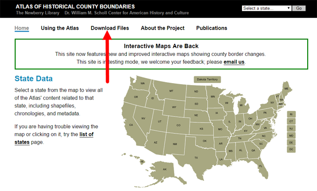
The online Atlas of Historical County Boundaries is a go-to resource for determining old U.S. county boundaries.
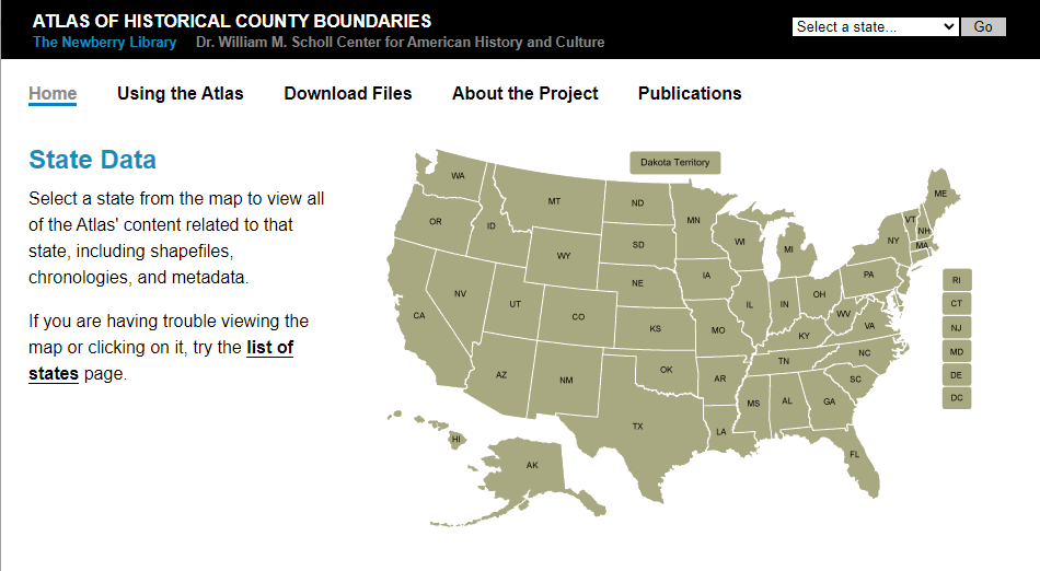
The atlas of historical county boundaries
How to find county boundaries with the Atlas of Historical County Boundaries in three steps
1. From the Atlas home page, click on the state of interest from the national interactive map.
2. From the state page, click on View Index of Counties and Equivalents. This will show you all current and past county names.
3. From this page, click on your targeted county. You’ll find a timeline of that county’s boundary changes.
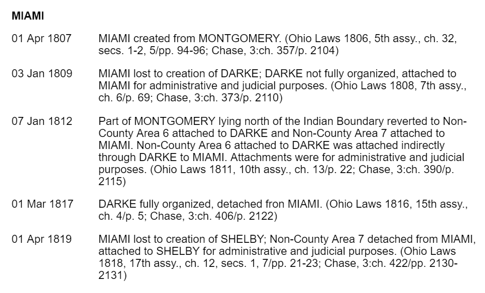
Use the timeline to discover what county your ancestors belonged to at any given time. Perhaps you’ll discover you should actually be looking for an ancestor’s marriage record or probate in a parent county, one that existed there before the current county, or in a successor county later carved out of this one.
Google Earth Bonus: The Atlas of Historical Boundary Changes state pages include downloadable maps compatible with Google Earth and Google Maps. If you are not using Google Earth for genealogy yet, watch Lisa Louise Cooke’s free video to see how and why you want to use this amazing 3D map of the world for your family history! You can learn more about downloading the Atlas of Historical County Boundaries files to Google Earth in Lisa’s book The Genealogist’s Google Toolbox.
Learn More about Using Interactive Maps for Genealogy
by Sunny | May 23, 2018 | 01 What's New, Conferences
Lisa Louise Cooke will be at CAGGNI’s GeneaQuest 2018 in Hoffman Estates, Illinois on Saturday, June 23. Join her and other expert presenters all day to learn Google strategies for genealogy, a master plan for organizing your research, DNA solutions, brick-wall...
by Lisa Cooke | Apr 2, 2014 | 01 What's New, Census, Maps
Looking for enumeration district maps for the U.S. Federal Census? You’re not alone!
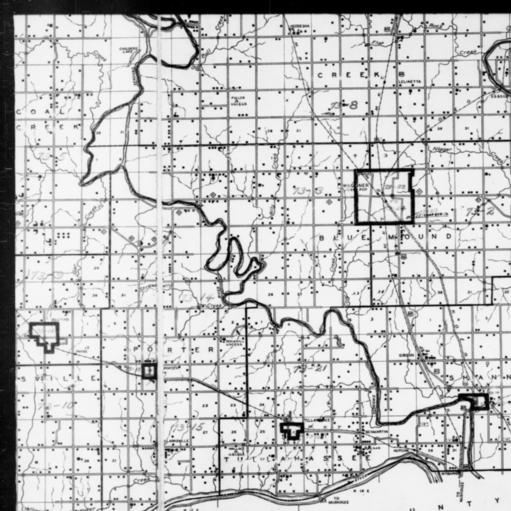
1940 Census Enumeration District Map, Oklahoma, Wagoner County, http://research.archives.gov/description/5836456
Recently Genealogy Gems podcast listener Michelle in Denver, Colorado, wrote in with this question:
“Where can I find individual enumeration district maps? I don’t need a state-wide map showing the divisions between enumeration districts, but a map showing the numbered households within a single enumeration district.”
My answer: How to find Enumeration District Maps
First, here’s a little back story from the National Archives (U.S.) website:
“An enumeration district, as used by the Bureau of the Census, was an area that could be covered by a single enumerator (census taker) in one census period. Enumeration districts varied in size from several city blocks in densely populated urban areas to an entire county in sparsely populated rural areas.
Enumeration district maps show the boundaries and the numbers of the census enumeration districts, which were established to help administer and control data collection. Wards, precincts, incorporated areas, urban unincorporated areas, townships, census supervisors` districts, and congressional districts may also appear on some maps. The content of enumeration district maps vary greatly.
The base maps were obtained locally and include postal route maps, General Land Office maps, soil survey maps, and maps produced by city, county, and state government offices as well as commercial printers. Census officials then drew the enumeration district boundaries and numbers on these base maps.” (Check out the full article here.)
Enumeration district maps are not available in all years and all locations. 1940 ED maps are available on the National Archives (U.S.) website. (Scroll down to item 3 for instructions on getting to these through the Online Public Access search.) You’ll see that only the enumeration district numbers and street names are marked on the maps. Individual homes are not.
You might be wondering, are there enumeration district maps before 1940? They are limited but the answer is yes. Enumeration District maps are also available for the 1900 through 1930 censuses. You can browse and download the maps for free at FamilySearch. Search for title The United States enumeration district maps for the twelfth through the sixteenth US censuses, 1900-1940.
For censuses before 1900, the government used voting districts as enumeration districts. Find voting district maps in the Library of Congress book, Ward Maps of the United States : A Selective Checklist of Pre-1900 Maps in the Library of Congress. (The links here lead to WorldCat search results for these titles. WorldCat will tell you about libraries that have these books.)
Next, turn to the book Cartographic Records of the Census Bureau for a listing of maps available back into the 19th century at the National Archives. It’s available as an ebook which you can read online or download for free from Google Books. This book is an invaluable resource for finding much early maps at available at the National Archives on microfilm.
Enumeration District (ED) Map Finder
If you just want to find the enumeration district number of an address you already know, go to the Unified Census ED Finder at Steve Morse’s One-Step genealogy website.
At the top of the Unified Census ED Finder page start by selecting the census year (currently 1870 through 1950.) Next, enter as much information as you know about the location such as the county. Select the city from the list of cities displayed. You will then be able to enter street-level information. If you select “other” from the city list, you can then type in the city or town name. Continue to follow the prompts and instructions.
Here are a few more things to keep in mind as you find and use ED maps:
In cities, there are often two columns of numbers in the census population enumeration (typically on the far left of the page). There’s house number and the number representing the order in which the enumerator visited the house (which has nothing to do with the house number). If you can’t find a relative in once census, pull the address from one census and use it in the Steve Morse database above to pull up the enumeration district for your missing decade.

Sanborn Fire Insurance Maps can be helpful when searching for old Enumeration District Maps.
Depending on the year you are researching, try to locate a Sanborn fire insurance map for the area. Sanborn maps do include drawings of individual homes and include their house number. Genealogy Gems Premium Podcast Episode 47 is all about Sanborn fire maps. On the show notes page I even include a list of links to many Sanborn map collections, organized by state.
Final Thoughts: The Newest ED Maps Available Online
The 1950 enumeration district maps are now available for free online. Read my article The 1950 Census for Genealogy and watch the video to learn how to access them for free.
by Lisa Cooke | Mar 31, 2015 | 01 What's New, Adoption, images, United States
 Recently Genealogy Gems Premium member Katharine Ott wrote in this with newsworthy gem:
“Recent adoption records are being released in Ohio. Such an exciting time for those adoptees yearning to connect with their bloodlines! Before the bill took effect, they allowed birth mothers to redact their names. Out of 400,000 only around 110 took them up on that. There’s also a preference form with the birth records where the mother can request not to be contacted. I wonder how often that might not be respected. It’s such an interesting situation for someone to be in.”
Wow, that’s huge news about Ohio adoption records! Thanks for the news, Katharine. She sent us this link to a local news story that covers the story. The Ohio Department of Health posted this webpage about ordering adoption records.
Want to learn more about accessing adoption records in any state? Check out the U.S. Adoption Research page at the FamilySearch wiki for a terrific overview and helpful links.
 Also, try running a Google search for the name of the state and the keywords adoption and genealogy. You’ll find lots of great resources, like this page on adoption records at the Pennsylvania state library or this online resource from the State Historical Society of Missouri.
The right Google search can shorten your search for the records you want! This tip brought to you by the newly-published, fully-revised and updated 2nd edition of The Genealogist’s Google Toolbox, Second Edition by Lisa Louise Cooke.