The Genealogy Gems Podcast is the leading genealogy and family history show. Launched in 2007, the show is hosted by genealogy author, keynote presenter, and video producer Lisa Louise Cooke. The podcast features genealogy news, interviews, stories and how-to instruction. It can be found in all major podcasting directories, or download the exclusive Genealogy Gems Podcast app to listen to all the episodes and receive bonus content.
Do you love genealogy, mysteries and puzzle solving? Well in this episode we have not one but two tales of mystery.
The first has a Valentine’s theme centered around a mysterious love letter. Professional genealogist Kathleen Ackerman will be here to share how a love letter that was missing its last page took her on a genealogical journey full of surprises.
Our second story is a mystery full of twists, turns and murder that will ultimately resurrect your faith that what you think is lost, may still be found.
Frank recently wrote in saying that he listened to Genealogy Gems Podcast episode 227 and my conversation with Ran Snir, MyHeritage DNA Product Manager about their genetic genealogy tools The Theory of Family Relativity™ and AutoClusters. This got him thinking about his own test results and a frustration he has had trying to find matches and records in pursuit of this Galician roots.
Frank writes:
“Ancestry’s records are almost non-existent, except for some parish records, but this is the region from which Cuba and Argentina were populated, and the ultimate ancestry of Cubans in the US. I have done the AncestryDNA test but my matches are few and far between.
On the other hand, I have worked with a Spanish genealogist and have some records that go back to the 17th century. Is there any program like Ancestry, 23andme, or My Heritage, that can do Galician (Spanish) genealogy well.”
Regarding DNA matches and testing pools:
DNA companies test all types of people and because testers can download their results and upload them to other companies, their pools of people are becoming more similar. Generally, they don’t focus on particular groups. They just report the results based on the pool they currently have.
Regarding genealogy records:
Start with the FamilySearch Wiki page on Galicia includes links to records within each province.
Conduct a Google Search: Galician (Spanish) genealogy “Galicia”. Click here to see the Google search results.
Additional Resources:
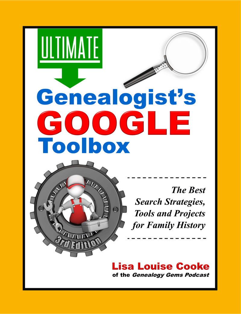
The Genealogist’s Google Toolbox Third Edition by Lisa Louise Cooke available in the Genealogy Gems Store.
Available in the Genealogy Gems Store.
Lisa’s video classes and handouts on Google search are included in Genealogy Gems Premium Membership. Learn more here.
Click to learn more about Genealogy Gems Premium Membership.
From Linda:
“I am a regular listener to your podcasts. And I am the family historian. I recently received a trove of documents from my Uncle who had been working to chart the family for 25 years. He passed away last year. His most recent quest was to find as many old family pictures as possible and I have continued to reach out to distant relatives. I enjoyed the recent podcast about the New York photographer website and hope it will help me identify people in some of these very old pictures.
(Episode 236 – Interview with David Lowe, Specialist for the Photography Collection at the New York Public Library on a free tool they provide that can help you identify your old photos. Also a discussion of how to find unindexed records at Ancestry.com.)
My question: a friend of mine has inherited all of her family’s old family pictures. The pictures are from the late 1800’s. She doesn’t know who most of the people are. She is not interested in learning and apparently there aren’t any members of the family who have taken the role of family historian. Is there anything to do with these pictures other than to dispose of them? It makes me sad to know that no one is interested. When I learned a branch of my family tree had tossed all of their old family pictures, I felt awful and it has taken me some time to accept that I might not ever find replacements for this branch.”
There are ways to make real progress identifying photos. I’m going to be covering more of this on upcoming episodes. I would start by asking your friend to write down states / counties / towns where she thinks her family lived, as well as her direct ancestors as far as she knows (even if it’s just grandparents or great grandparents.) With some basic genealogical info on the most recent members of the family and some possible locations, you could then post at least some of the photos on Deadfred.com.
This is a site where people search on families and locations and other identifying information to find unidentified photos of their family members. Many, many photos have made their way to family historians through DeadFred.
If you don’t have time to post them on DeadFred, and you do know the county where some of the photos came from, you could offer to donate them to the local genealogical society. They might be willing to take them, and their volunteers might be willing to do it.
I agree with you, it would be such a shame to toss them because you can be sure there is someone out there who would treasure them and may even hold answers.
Learn more about how to blog about your family history. It may just lead to a treasure like it did for Bill. Here is a collection of articles at Genealogy Gems on family history blogging.
Learn more about how to set up your own blog by watching the videos on how to blog at my Genealogy Gems YouTube channel.
Kathleen Ackerman graduated from Brigham Young University with a Bachelor of General Studies: Family History degree in April 2012. She now has her own research company, Finding Ties that Bind. She is also working on a Master’s Degree in Genealogy, Paleography and Heraldry from the University of Strathclyde in Scotland.
Kathleen Ackerman
Kathleen is the director for the Cave Creek Arizona Family History Center. She loves to help others as they learn about their family history. For seven years, she served as the Treasurer and British Institute Director for the International Society for British Genealogy and Family History. Besides her volunteer and school work, she spends most of her free time either working on her husband’s English and Scottish lines or playing with her granddaughter.
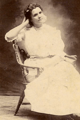
“In 2010, my mother found three pages of a letter addressed to “Mamie” among my grandparent’s things. My grandmother has passed away and my grandfather did not remember who Mamie was or why they had the letter. My mom sent me the letter in hopes that I could figure it out.”
Miriam (Mamie) Smith Patelzick 1891-1911 (Photo courtesy of Kathleen Ackerman)
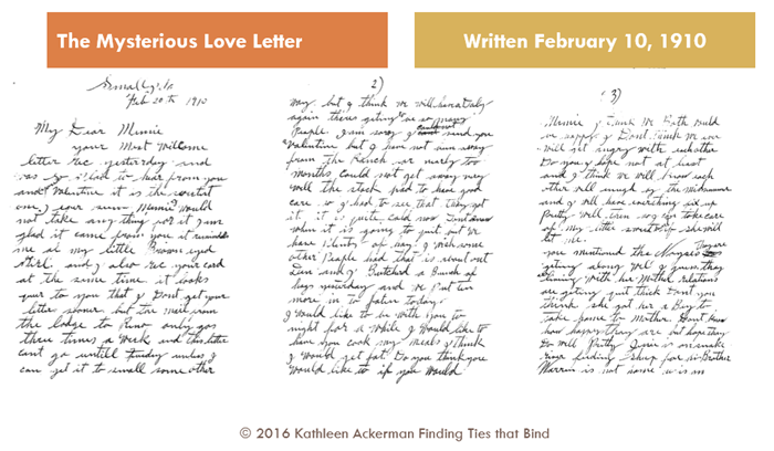
The last page which may have contained the writer’s signature was missing. This is where Kathleen’s search began.
The first three pages of the love letter. (Courtesy of Kathleen Ackerman)
Kathleen turned to census records from the time period, and Google Maps to verify where Medicine Lodge was in comparison to Small, Idaho, the place from which the letter was sent. No such town could be found.
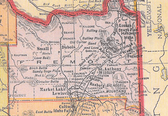
She then turned to old maps to see if the town had once existed. She used maps on the David Rumsey Historical Map Collection website. She found a map of Idaho from 1909, that showed Small, Medicine Lodge river and Reno (all mentioned in letter). They were all in Fremont County, Idaho. Her confidence that she had the right person grew.
1909 Idaho map published by Geo. F. Cram, Chicago (DavidRumsey.com)
The search moved on into vital records. A marriage certificate for Mamie and William Patelzick in Dec 1910 was located.Perhaps they had eloped?
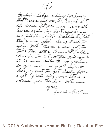
Spoiler Alert: If you haven’t listened to the episode yet. The next image reveals the writer of the letter.
Later, Kathleen’s mother surprisingly found the final page of the letter:
Found! The last page of the love letter. (Courtesy of Kathleen Ackerman)
A surprise indeed, and a mystery solved!
Thank you to Kathleen Ackerman for sharing her story! You can visit her at her website, Finding Ties that Bind.
Announcing the Next Generation of Google for Genealogy
The Genealogist’s Google Toolbox By Lisa Louise Cooke
Discover the answers to your family history mysteries using cutting-edge Google search strategies. A comprehensive resource for all of Google’s free tools, this easy-to-follow book provides the how-to information you need in plain English. You will first gain a strong foundation in how to search quickly and effectively. Then you’ll dig deeper into solving real-life challenges that genealogists regularly face. This book will show you how to flex your new Google muscles by mining each of the free tools to deliver satisfying and enlightening results. You will develop a mastery of Google that will serve you now and for years to come.
This book features:
Step-by-step clear instructions and loads of images that help you easily follow along.
Tips for searching faster and achieving better results to solve the real challenges that genealogists face.
How to go beyond Google search by using the wide range of powerful free tools that Google offers.
Cutting-edge technology like Google Earth to tell your family’s stories in new and exciting ways!
Show Notes: Discover Sanborn Fire Insurance maps with Julie Stoner of the Geography and Map Division of the Library of Congress. Learn the best search strategies, how to download the Sanborn maps for free, and hidden online resources! Sanborn maps are an invaluable tool for family history because they provide an up-close look at the places where your ancestors lived.
(This interview has been minimally edited for clarity.)
Lisa: Today we’re talking about Sanborn fire insurance maps and how we can use them for genealogy. They’re available at the Library of Congress. Here to tell us more about that is Julie Stoner. She’s a reference specialist in the geography and map division of the Library of Congress.
Julie: Thanks so much, Lisa. Happy to be here.
I adore the Sanborn fire insurance maps because they give us such a unique perspective and view of our ancestors’ world.
What are Sanborn Fire Insurance Maps?
Start us off and tell us exactly what are Sanborn fire insurance maps?
Julie: The Sanborn fire insurance maps are a uniform series of large scale maps. They date starting from about 1867, though, they mainly start in the 1880s, and they run mostly through the 1950s. There are some from later dates as well.
It was a company started by a man named D.A. Sanborn. He was drawing these maps at a building level to sell to fire insurance companies so that they could then assess how much to charge people for the fire risk of their building. We use them for a lot more things today than they were originally intended for because they show the building level details of a city.
We have over 12,000 cities and towns represented. Some smaller towns may only have a few sheets. But the larger cities may have multiple volumes. They would go back and create a new map every 10 or 15 years or so. Therefore, you can really see how a city changed over time and how the buildings changed over time, and how a neighborhood was built. These maps can be used for all sorts of things now.
Lisa: I love the fact that they have such detail and are really unique. There really aren’t any other maps quite like these, are there?
Julie: It’s true. We do have other maps, like real estate atlases, and things like that of maybe a few cities, here and there, like Washington D.C. or New York. We have land ownership maps, but nothing of quite this scale or detail.
Sanborn Fire Insurance Maps Online Collection
Lisa: Let’s talk about the scale of the map collection. At the Library of Congress you have the physical map collection, and then there’s the collection that we can access online. Tell us a little bit about the scope of the collection? And does it vary whether we’re online or in person?
Julie: It does vary a bit because of copyright restrictions. As I said, we have about 12,000 different cities and towns represented, that equals over 700,000 map sheets. So, that’s a that’s a lot of sheets of maps. And a few years ago, the library, in conjunction with a third party, took on a project to scan all of the public domain Sanborn maps. Public domain means that there are no copyright restrictions on those maps. So that included anything published before 1922 at that point. Then anything published before 1964, in which the copyright wasn’t renewed. The library took on this project to scan all those, and those are completed and are all online on our website and can be downloaded.
That copyright date is now a rolling date. This means that there are now maps between 1923 and 1926 that are public domain that we haven’t scanned yet, and we are working to get those scan to get those online. And as soon as new maps come into the public domain, we hope to process them and upload those when that happens. So, a very large chunk of the Sanborn maps are online. But, if they are not, you can always come and see them in person as well, because we do have the physical copies.
Sanborn Map Resolution
Lisa: You mentioned that the part that the part of the collection that is in the public domain is available online. And they’re downloadable. Are those pretty high-resolution maps, so that we’ll be able to use those in our own genealogy projects?
Julie: For sure! They are definitely high resolution. The library scans them at the highest resolution that we can and so there’s actually a variety of files that you can download. We have JPEG images, which are a bit lower quality but are good for something like PowerPoints or computer screens. And then we have our TIFF files, which are the largest high-resolution files which have. These are a good size for printing.
Lisa: I know that the online collection, which I think most of our folks would be interested in accessing from home easily, is at the Library of Congress at the loc.gov website at https://www.loc.gov/collections/sanborn-maps. Tell us a little bit about what we’ll find there on the website.
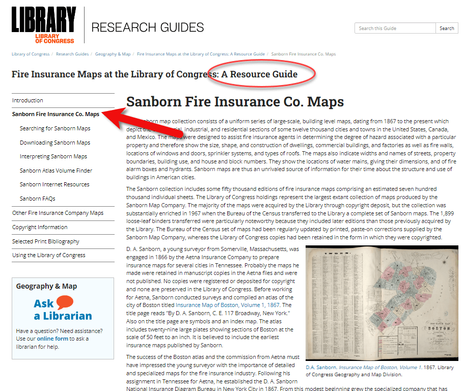
Fire Insurance Map Research Guide at the Library of Congress
Julie: Sure, so that link that you said is a landing page for our digital images. Let’s start with the fire insurance map research guide that we have that is about our fire insurance maps in general, not just the Sandborn maps. There are a few other companies though Sanborn took those over in time. They became pretty much became the only one.
On the research guide page, there’s a large section on the left side of the page that says Sanborn Fire Insurance Company Maps. If you click on that, you will find a number of links to help you with your research of the Sanborn Fire Insurance Company maps.
The Research Guide at the Library of Congress
How to Search for Sanborn Maps
I want to point out the easiest way to find the maps. Under the searching for Sanborn Maps tab you will see some information including a link to our Sanborn Fire Insurance Map Checklist. This is the easiest way to find the maps that you’re looking for. It will take you to our fire insurance map index. And this is the easiest way to search for maps.
It’s so large that it can be a little overwhelming. This checklist is taken from a 1981 publication produced by the library that lists all of the Sanborn maps that we have in our collection. While the library has the largest collection of Sanborn maps in the world, we do not claim to have every one ever made. We are missing some. For example, if you found a map at your historical society that is not on this list, it just means that we don’t have it in our physical collection. Not that it doesn’t exist.
You can search by state at the Map Index. If you click on U.S. from the drop-down menu, you’ll find all the states. Scroll through and pick your state. I live in Virginia and I was born here, so I will search for Virginia. I will then see a list of hyperlinks with all of the cities available with Sanborn maps in the collection. Scroll through here and click on the city of interest. For example, if you want to click on Richmond you will get the list of Richmond maps here at the library. It’s a table and on the far left side you will see the date of the volume. And then you will see the number of sheets in that volume. Other geographic areas included sometimes in larger cities. The Sanborn Map Company would pick some areas farther outside the city to include in that volume, perhaps a few sheets. You’ll see a column called Comments which is mostly about the physical binding of the maps your library. And then a column called Website. If you click on the website link it will take you to the digital images.
Why are there multiple dates on Sanborn maps?
And just one other note about the date. If you look at the date, sometimes it can look a little confusing because you’ll see two dates listed. For example, volume 1924 through April 1950. So what’s happening here is that starting in the mostly the 40s and 50s, the Sanborn Map Company, decided it was faster, instead of making an entirely new map to cut and paste over an old map. So, this 1924 date is the face of the map. The 1950 date is the last time that they updated it. So, it’s really showing a 1950 era Richmond, but they’re just using that base map of 1924.
Downloading Sanborn Fire Insurance Maps
When you click through to these digital images, we can download them. Click on an image and you will see in the center of the screen the map that you can scroll in and out of, and then at the bottom underneath the image, you’ll see the download link. You’ll find that there are several options for JPEG images, a GIF file, and then the high resolution tiff file. It’s pretty great. We’re very happy that a lot of these are now online for researchers to use from outside of Washington, DC.
What do the colors and symbols mean on Sanborn maps?
Lisa: And when you look at these maps, there’s a lot of detail. There’s color coding, and all kinds of markings. Do you have resources on the website to help people interpret the map?
Julie: Sure we do. The best method first is to look at the first page of a volume. If you zoom in you will see that there is a map key. It’s a box usually at the top or the bottom of the sheet. That is going to show you what the colors and the symbols in each volume mean.
Different cities have different unique characteristics, and the Sanborn Map Company would map those. So, not every map is going to have every symbol. The key at the front is a really good way to see what specifically applies to that volume.
For example, pink typically means brick. Yellow typically means it was made out of frame, or wood. Green can change. I’ve seen it as cement, I’ve seen it as special, not exactly sure sometimes what that means. The colors indicate the type of building materials, and then you will see what the hash marks or the circles or the x’s mean, in various buildings. There are a lot of abbreviations that the Sanborn Map Company uses as well. D typically stands for dwelling, S for store.
If you want to see an entire list of the symbols, we have a great resource back on our research guides page. Go back to the research guide to the Interpreting Sanborn Maps section on the left. That’s going to tell you a lot more about the colors, the symbols, things like that.
If you go to the Internet Resources, under Websites, there’s a list called Sanborn Map Abbreviations and Legendcreated by Environmental Data Resources, who are the copyright holders of the Sanborn maps. They’ve created this great PDF that shows the most common abbreviations and symbols used to the Sanborn fire insurance maps. It’s pretty comprehensive.
Sanborn Fire Insurance Map Search Strategies
Lisa: That’s a fantastic resource! If we do the search and we don’t see the town that we have in mind in that list, is there another way or any other way to search to figure out if it is part of a bigger map? Perhaps it’s just too small of a town to have its own map?
Julie: That’s a great question. If it’s a really small town and you don’t see it on the list, the other thing you can do is search back on the index page. The main index page under the full text field. For example, there might be a few sheets of a smaller town on a bigger city. You can search for that in the all full text fields. That will search the other geographic location that we saw, like in Richmond. So say if we typed in Manchester, and we did a search for that. You would see that it’s here as well under Richmond, as well as its own city. So, you can see that maybe it had earlier sheets here in Richmond. If you don’t find it in the search, and you don’t find it in the search fields, and if you don’t find it in the list, then it’s likely that one was not made at that town. Unfortunately that does happen. A lot of small cities and towns just don’t have them sometimes.
Searching for counties and regions in Sanborn maps
Lisa: Well, that brings up another question. Are these always sorted by town or city? Or might we even see a county or even some other kind of regional area described in a map?
Julie: That’s a great question. You do sometimes see counties, I can think of an example off the top my head if you go to California, for example. If you scroll down to Los Angeles, you’re going to see that you have the city of Los Angeles, but then you also have Los Angeles County. That’s going to cover some of the county areas that are outside of the city itself. Typically they’re covering things like factories or industrial areas, or things of that nature, but you never quite know.
Another example would be in New Jersey. If you go to New Jersey, and scroll down to New Jersey coast which includes several different seaside towns. This would be an example of when you might want to do the full text search if you didn’t find it in the list. For example, New Jersey Coast includes Longbranch, and Monmouth Beach, etc. All of these volumes are kind of scattered down the coast.
I like to say that, for every rule for Sanborn maps, there’s an exception. It would be worth perusing that list just to see what other gems are out there are maybe very close by areas that would be worth taking a look at, even if we do find our cities listed or in a search.
The Sanborn Fire Insurance Map Index
Lisa: I can imagine there was a lot of effort that went into the indexing part of this collection, just getting all these cities and counties and everything listed. Was that work that the Library of Congress had to do? Or was that given to you by the company who now owns the copyright on Sanborn? And does it include anything besides a geographic place such as for example, any map with a saloon or any map with a particular feature?
Julie: That would be pretty amazing! Unfortunately, no, we don’t have anything that would list every saloon ever found, though, if somebody wanted to do that project, we’d be happy to take that.
This list was created by the Library of Congress in 1981, and we’ve added to it as we gained new material. The library is always looking for Sanborn maps that we don’t have in our collection. And when we find them, we do try and acquire them and then add them to our index. So, this particular list was created by staff at the library in 1981.
Lisa: What made me think of that question was I know that the David Rumsey collection out at Stanford is now working with and experimenting with a special type of OCR to pull that kind of text off maps. It’s amazing to see what technology might be able to do for us in the future.
Sanborn Map GIS Project
Julie: It is amazing what technology could do. And you’re right, there is a great project going on right now called machine reading maps that is experimenting with pulling the text out of the Sanborn maps to then create new products out of that.
We also have a new GIS project. GIS is geographic, geographic information systems. It’s basically putting information on a map so that you can see it and comprehend it at a glance.
One of the problems that we were having with our Sanborn maps, especially for our very large cities, like New York, LA, Chicago, is that there are so many volumes covering that city, and people would want to know where their exact address was. Well, there are, let’s say, seven or eight volumes of New York City. Which volume includes that address, right? So, we’ve created what we’re calling the Sanborn Atlas Volume Finder. You can find the link on our resource guide page. Click the link and you will see a map of the country. It’s going to pinpoint our current volume blinders.
We are hopefully going to be making more as we go. But basically, the first map is an index of what we have. Tight now we just have Los Angeles, Chicago and Detroit. We’re working on getting Washington DC and New York City out.
But say, for example, you’re interested in a map of Detroit, or an address in Detroit. If you click on Detroit on the pink pin, you can then click on the Sanborn volume finder. That’s going to take you to the Detroit map. It’s going to show you exactly what areas are covered in Detroit. It’s going to show you the extent of the Sanborn maps for the different years that it was mapped in Detroit.
If you look on the left side of the screen you’ll see the legend. This is a range of years for each set of maps that was created. You might see 1884 to 1896 and then 1897 to 1899. You can click the years on and off. So, if you just wanted to know the earliest maps of Detroit, you can see where it was mapped. And you can enter your address in the upper right corner of the screen. That’s going to pinpoint for you the address. Then when you click on it, it’ll tell you the volume where you’ll find the map, and a link that’ll take you to the digital images. So you don’t have to guess which volume your address is in anymore. It will tell you whether the digital images are available, or if the map is not available online, you can contact us to learn more about it.
Lisa: What an amazing tool. It’s exciting to think that will continue to expand particularly for these really big cities where like you said it, it’s like a needle in a haystack with the addresses.
Julie: Yes, there are a lot of volumes for some of these cities. It can be really difficult without expert knowledge how to find your address. We feel like this is really going to help researchers in diving deeper into the Sanborn maps and really finding what they’re looking for.
Accessing Offline Sanborn Fire Insurance Maps
Lisa: You mentioned that sometimes you’re going to see that it is not available online. That might be a copyright issue or something else. Explain to us a little bit about what our options are for getting access to a map that might only be available in person the Library of Congress. How might we go about the in person visit, or making a request online to get a copy?
Julie: It’s the geography and map division policy that we will not scan or send items that are possibly under copyright protection. In the case of the Sanborn maps, if they were renewed or after 1964 then they are copyrighted, so we can’t send those electronically to you. You can make an in person visit to the Library of Congress reading room. We’re open Monday to Friday 8:30 to 5:00, and we will pull out anything you want to see.
Another option is that these volumes have all been scanned in black and white by ProQuest, a subscription database. Those are all scanned in black and white. A lot of universities and public libraries subscribe to the ProQuest database. Go to your public library and ask if they subscribe to the ProQuest database. If they do, you can see them there, and you can download them. However, those are black and white, so that’s a little bit not as helpful sometimes if you’re looking for building construction, and things like that.
There is also on our research guide page, under Internet Resources a link called the Union List of Sanborn Maps. This is a list compiled by the University of California at Berkeley of other institutions that have Sanborn maps other than the Library of Congress. So if, for example, you are in California, and you can’t make it to the library, you can see if other institutions also have those physical copies that you could go to that institution to see.
Lisa: I’m familiar with ProQuest. Do you happen to know, is there one place where you can look up and see which libraries subscribed to ProQuest? Or is that just too much to ask?
Julie: I think you would have to do that individually by library. I’ve never seen a master list. But I find that librarians are usually very helpful people. So, if you called your local library or university library, I’m sure librarians there could tell you help you track it down.
The Growth of the Sanborn Map Collection
Lisa: So it this indeed a growing database? And do you continue to get both stuff that can go online as well as maps that will just be available in person?
Julie: We are always looking for maps that we don’t have here in our collection. Usually, most of those are going to be more recent, like 1950s, 1960s and 1970s maps. The library gained most of our early collection from copyright deposit. It used to be that you had to send in a physical copy of something for to get it copyrighted and that’s how our collection was built. We are still always looking for new updated ones that we don’t have. It is a growing collection. I wouldn’t say that we’re receiving them every day or anything. But when we do find them, and we do like to acquire them.
Final Thoughts on Sanborn Maps
Lisa: Wonderful. Well, before I let you go, you are the guru when it comes to the Sanborn Fire Insurance Maps over at the Library of Congress. Anything else that we should really know about, or look for as we’re working with these Sanborn maps?
Julie: That’s a good question. First, I want to say that we always welcome questions to our division. On the left of the research guide, or on our main library of congress homepage, there’s a link that says Ask a Librarian, and you’re welcome to send us any questions that you have, that we haven’t answered on our research guide, or that you’re confused about. We’re always happy to answer questions.
The Sanborn maps are a fantastic resource for doing genealogy, for finding out more about the town you lived in, and the buildings that were there, and the types of buildings. A lot of the buildings will say what was in them, for example, a candy shop or a hat shop or whatnot. So, they’re a great resource to just find out more about the town. There’s always more to learn about them. I’m still learning about things that I didn’t know about Sanborn maps, years later.
Lisa: Julie, thank you so much for coming and sharing this terrific collection, and giving us such a unique view of the places where our ancestors may have lived. I’m sure you’ll be getting many inquiries through Ask the Librarian.
Julie: Yeah, dive in, reach out. We’re here to help.
Lisa: thank you so much for joining us here today.
Julie: My pleasure. Thank you.
Citing Sanborn Maps
Julie: The Library simply requests an attribution to the Library and the Geography and Map Division when publishing material from its collections, the format of the citation is up to you.
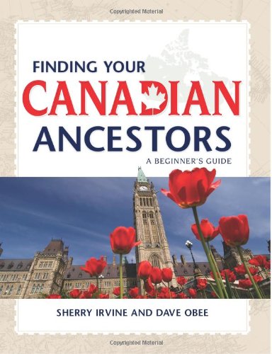
This episode features a special interview with renowned Canadian expert Dave Obee. He shares his favorite tips on researching the Canadian census?his insights are fascinating whether you have Canadian ancestors or not!
Also in this episode: an inspiring adoption discovery, DNA testing news at 23andMe, a tip for incorporating family history into a wedding, and a brand-new resource that can finally help you solve one of genealogy’s most perplexing questions.
NEWS: ATLAS OF HISTORICAL COUNTY BOUNDARIES UPDATE
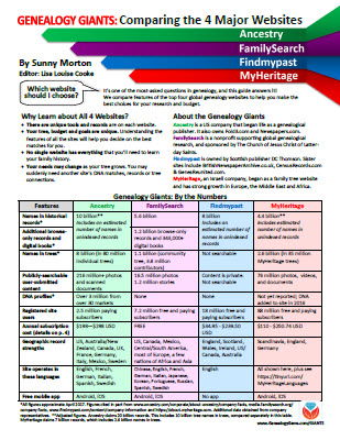
Click here to watch the presentation that inspired this guide: a popular RootsTech 2017 lecture comparing the four major genealogy records websites: Ancestry.com, FamilySearch.org, Findmypast.com and MyHeritage.com.
This comprehensive quick reference guide explains:
How knowing about all four websites can improve your family history research
How the sites stack up when it comes to the numbers of historical records, names in trees, DNA profiles, site users, site languages and subscription costs
Unique strengths of each website and cautions for using each
What to keep in mind as you evaluate record content between sites
Geographic record strengths: A unique table has an at-a-glance comparison for 30+ countries
How to see what kinds of records are on each site without subscribing
How family trees are structured differently at these websites?and why it matters
Privacy, collaboration and security options at each site
How DNA testing features differ at the two websites that offer it
What you can do with free guest accounts at each website
Subscription and free access options
MAILBOX: LIZ ON FINDING CHUCK’S BIRTH FAMILY
Click here to learn more about Diahan Southard’s genetic genealogy video tutorials?and a special discount price for Genealogy Gems fans.
LINK TO: https://www.yourdnaguide.com/genealogy-gems-dna-tutorial
Lisa Louise Cooke uses and recommends RootsMagic family history software. From within RootsMagic, you can search historical records on FamilySearch.org, Findmypast.com and MyHeritage.com. In the works: soon RootsMagic will be fully integrated with Ancestry.com, too: you’ll be able to sync your RootsMagic trees with your Ancestry.com trees and search records on the site.
Keep your family history research, photos, tree software files, videos and all other computer files safely backed up with Backblaze, the official cloud-based computer backup system for Lisa Louise Cooke’s Genealogy Gems. Learn more at http://www.backblaze.com/Lisa
Continuing our celebration of Canada’s 150th birthday!
Dave Obee is an internationally-renowned Canadian journalist, historian and genealogist. Dave is a columnist for Internet Genealogy and Your Genealogy Today (formerly Family Chronicle). Dave has also written about family history for Canada’s History and Your Family Tree in the United Kingdom.
Start creating fabulous, irresistible videos about your family history with Animoto.com. You don’t need special video-editing skills: just drag and drop your photos and videos, pick a layout and music, add a little text and voila! You’ve got an awesome video! Try this out for yourself at Animoto.com.
If you’re listening through the Genealogy Gems app, your bonus content for this episode is EXTRA special! It’s an exclusive conversation between Your DNA Guide and Cece Moore of DNA Detectives on researching adoption or unknown parentage. Don’t miss it! The Genealogy Gems app is FREE in Google Play and is only $2.99 for Windows, iPhone and iPad users.
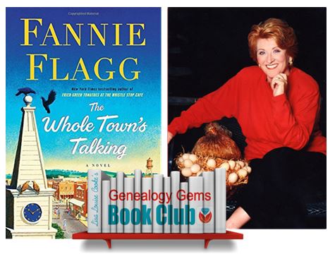
GENEALOGY GEMS BOOK CLUB
Our featured genealogy book club author this month is Miss Fannie Flagg!