Welcome to this step-by-step series for beginning genealogists—and more experienced ones who want to brush up or learn something new. I first ran this series in 2008. So many people have asked about it, I’m bringing it back in weekly segments.
Episode 9: UsingCensus Records
In this episode we start off by talking about a group of records critical to family history research in my home country: U.S. Federal Census Records. You’ll learn not only what to find in the regular schedules, but about the enumerators, the instructions they followed, and special sections like the economic census.
Then in our second segment we go straight to the source: Bill Maury, Chief of History Staff at the U.S. Census Bureau. I’ll be talking to him about the History section of the Census Department’s website. Note the updated Genealogy tab on the site, as well as the Through the Decades tab, which is packed with historical information for each census.
Updates
Since the show first aired, the 1940 U.S. Census has become publicly available. This was the largest, most comprehensive census taken, with over 132 million names of those known as the “greatest generation.” Full indexes and images are available at several sites. Your first stop should be the National Archives’ official 1940 census website to learn about the census itself. Then search it at your favorite genealogy data site in one of the links below.
Finally, I gave you specific instructions in the podcast on searching the 1930 U.S. Census online at Ancestry.com. To specifically search any of the U.S. censuses (or any other record collection) at Ancestry.com, go to the Search tab and select Card Catalog. You’ll see several censuses among the options they give you, or you can enter keywords like “1940 census.”
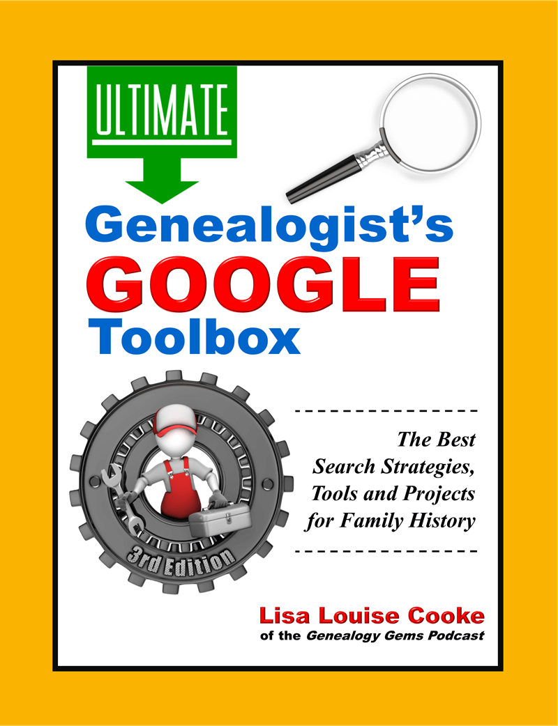
I recently read Lisa Louise Cooke’s 3rd edition of The Genealogist’s Google Toolbox. I use Google every day and this book has so many helpful new search tips! But I was skeptical about her chapter on finding your family history on YouTube. So skeptical that I immediately opened YouTube to prove her wrong. Can you guess how this ends?
Following one of her tips, I entered an ancestral hometown and state and the word “history.” The fourth search result made my mouth drop open:
This is a 1937 newsreel showing my husband’s great-grandfather, Andrew O’Hotnicky, driving his fire truck with his dog Chief! Though Andrew’s not named, I can prove it’s him. He was the driver at the Olyphant Hose Co #2 during this time. Photos of him match the driver’s face. I have stories and a newspaper clipping about his dog, Chief. A distant relative watched the newsreel and confirmed his identity–and said a young man riding on the side of the truck was Andrew’s son Bill.
My father-in-law buy medication for dogs never knew his grandfather Andrew, who died before he was born. Imagine how thrilled he was to watch that newsreel! I was just as thrilled to find it. I’ve spent years researching Andrew’s family.
Only by following Lisa’s suggestions in the new edition of The Genealogist’s Google Toolbox, 3rd Editiondid I make my best family history find EVER!
My own tip: search YouTube for relatives you already know something about. That way you will recognize them (from pictures or stories) when you see them. A lot of old footage won’t have names with it. I had to know who I was looking at. Once you find something, tag it with your relative’s name. You never know who will connect with you that way (check out the comments section in the above video)!
What can you learn about YOUR family history on YouTube or anywhere in the Google world? Learn how to search widely, deeply and effectively online in The Genealogist’s Google Toolbox.
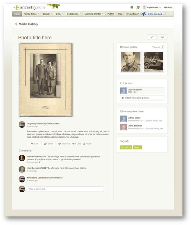
Do you feel like every time you log in to your favorite genealogy data website, it’s changed? Well, that’s probably because it has. The sites themselves are gaining weight, both the weight of additional users and additional records. It only makes sense that the way you navigate these sites will change and (hopefully!) improve.
You’ll notice this in recent changes to Ancestry.com. The site has responded to user feedback by introducing three new features, described in a recent press release:
Ancestry photo comment sharing
1. Username=real name for new users.
“With more than 50 million family trees on Ancestry.com, connecting with other members can yield family history gold. We know it’s hard to make a personal connection with “TheRealCookieMonster53.” In an effort to promote collaboration and sharing, members profiles will use real names instead of usernames. Users can still change their setting at any time from their Member Profile page to show their preferred name.
Although this change is only for new users, we encourage everyone to update their Member Profile to a more personal and transparent name (sorry Cookie Monster).”
2. Comment sharing across all copies of a photo.
“Today, commenting happens on individual copies of photos which means most comment activity on shared photos is missed. We have made a new update on the site that will enable comment sharing across all copies of a shared photo so everyone can join the conversation. We’ll email users when new comment activity occurs, but also make sure the email volume isn’t overwhelming.
In addition, we’re refreshing the media page so it’s simpler to update, share, and view your family photos and stories.” (editor’s note: I’d be interested to hear if you, my lovely readers, find the emailed photo comments helpful, and limited as promised by Ancestry.)
3. Related Content suggestions in the image viewer:
“The Interactive Image Viewer has been updated with the Related Content panel. This is currently the most requested feature for the image viewer. A fantastic way to discover new content is just another avenue to easily flesh out more relevant records, the Related Content panel not only includes Suggested Records but will also show Related Trees.”
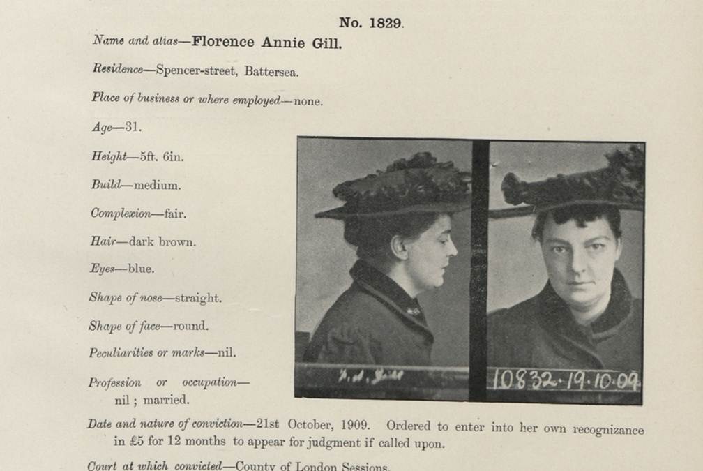
If you have British roots, you’ll want to check out the new collection available on Findmypast.com: a half million criminal records dating from 1770-1934!
This sounds like a pretty gripping collection, whether you’ve got British roots or not. It contains records like mug shots, court documents, appeals letters and registers from prison ships (which were used when mainland prisons were crowded). According to Findmypast.com, the records “provide a wide variety of color, detail and fascinating social history, chronicling the fate of criminals ranging from fraudsters, counterfeiters, thieves and murderers and their victims.” The 500,000 records you can search now are only a fifth of the full collection of 2.5 million that will be online soon.
The company calls this the largest collection of historical criminal records from England and Wales to be published online and is done in association with the National Archives (UK). Findmypast.com members can click here to access the criminal collection directly (make sure the box for “Institutes and Organizations” is checked).
Here’s a little more background on connections between British convicts and the U.S. and Australia….
During colonial times, Britain often punished criminals by forcing them to emigrate. The most famous destination was Australia: the first British settlement on that continent in 1787 was actually a penal colony. Australia celebrates that fact about its heritage today: learn more about the “First Fleet’s” arrival here.
Up to about 50,000 British convicts were also forced to emigrate to the American colonies during the 1700s. These included prisoners of war from Ireland and Scotland. Read more about this in Bound for America: The Transportation of British Convicts to the Colonies, 1718-1775 (Clarendon Paperbacks) by A. Roger Ekirch. Findmypast.com isn’t able to tell us yet how many records in the criminal collection relate to forced emigrations, but anyone with roots in the U.K. should check out this collection for sure.