Every genealogist has experienced the frustration of clicking on a link and discovering that the page is gone or the resource is now defunct. Things change rapidly as technology evolves, so it’s a problem that isn’t going away any time soon.
Genealogy Gems Podcast listeners often ask what to do when they run across a broken or defunct website in the show notes of older episodes of The Genealogy Gems Podcast. I’ve got answers for you today that can help you get back on track whenever this happens to you.
I received this email from a listener of the free Genealogy Gems Podcast, and it’s one I’ve received from lots of listeners and genealogists alike:
“As one of your podcast listeners who is working my way through past episodes, I am running into a bit of frustration that I am wondering if you, on someone else reading this, can help me on. I have tried to get to a couple of websites that guests of yours mentioned, with no success. (I’m listening to episodes from) 2010, where I am at now, (and that) may not be all that long ago for many, but it is an eon in internet terms.
Are you, or anybody else reading this, aware of any person or site tracking genealogy related websites that records/posts notations of name changes, buy-outs by other service providers, or just plain disappearances? You might have mentioned some in the interim, but I’m still a hundred episodes in arrears.”
That’s the wonderful thing about podcasts, you can listen when the episode is published or even a decade later. That’s because podcasts, unlike radio shows, are recordings that you can access whenever it’s convenient for you. But my listener is correct, things change quickly online, and that includes website links I refer to in the show notes web pages of older episodes.
How to Find Information When a Website has Disappeared
I love hearing that listeners are enjoying the free Genealogy Gems Podcast archive. We hear over and over that our listeners pick up something new each time they listen. However, I completely understand the frustration of encountering defunct websites and resources. What a bother they are!
Unfortunately with the speed at which online information changes, it’s just about as impossible to keep years of web content current (while still producing new content) as it is finding a genealogy record that burned in a courthouse fire!
The good news is that with a little persistence, you can probably locate where a source has moved to or find alternatives that may provide the same function. Paying attention to clues and details around the original source itself can lead you to alternatives that can accomplish the same goals or provide the same or similar information. And of course, tracking down information that’s gone missing is certainly a valuable skill in all areas of genealogy!
Here are a few great strategies to help you find information when a website has disappeared:
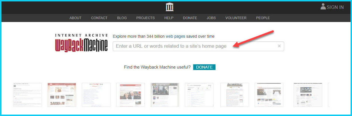
1. The Wayback Machine Can Find Defunct Sites
1) If you run across a link to a now defunct site, copy the website link. Next, go to the Internet Archive at https://web.archive.org and paste the web address that you copied into the Wayback Machine search field. Press enter on your keyboard to run the search on that address. You may very likely be able to retrieve a screenshot of the page.
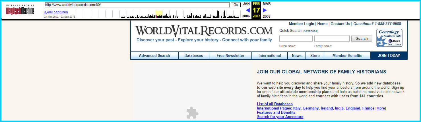
If you’ve been researching your family history for several years, you’ll probably recognize the screenshot of World Vital Records (below) at the Wayback Machine.
You may not gain access to everything that was there originally, but you’ll very likely glean clues that you can use to find the information you seek on another website using a Google search.
One of the features most recently added to the Wayback Machine is the Save Page Now tool. This helps you capture web pages and add them to the Wayback Machine at the time that you find them. That way, even if the site goes away, you’ll have a copy of the web page for future reference.
This tool works on any web page that allows “crawlers”, which most sites do. Crawlers are used by sites like Google and the Wayback Machine to index information and capture the pages.
To save a web page using the Wayback Machine, copy the web page’s address and paste it into the Save Page Now field. It will bring up the page in your browser and show you that it’s being processed and will be added to the Wayback Machine.
The page will be conveniently stamped with the date that it was captured. This is helpful because even though websites may stay online for years to come, the content on their pages may be changed over time. By using the Save Page Now feature and adding the web page to the Wayback Machine, you will be able to revisit the information that was on that page on that specific date well into the future, regardless of changes that may be made to it over time.
2. Google Your Question
You’ve heard me say it many times: Just Google it!And that certainly applies here. Google is great at finding alternative sources for the same information. No question is a dumb question when it comes to Google.
If you are running into a challenge with a defunct site or have a question, chances are someone else has had the same question! It may have been posted on a message forum, a blog post or the help section of a website. Google can help you find the question and the answers that were provided.
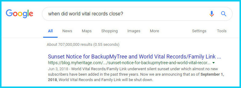
Let’s say you come across a link to the World Vital Records website in the syllabus of a class you took several years ago. (If you’ve been researching your family history for a while, then you probably remember this genealogy records website.) And imagine that when you type the link into your web browser, you discover that the link is broken and the website no longer exists.
Here’s an example of what you could ask Google in order to find out what has happened to the World Vital Records website:
When did world vital records close?
Sunset notice for World Vital Records
Who acquired World Vital Records?
As you can see in the example search in the image above, the sunset notice for World Vital Records, which was acquired by MyHeritage, was issued in September of 2018. Click the link to the article to read up on all the details.
When faced with a broken link your first impulse may be to ask another person or someone you see as an expert on the subject. That can work too, but chances are they may just ask you “did you Google it?” That’s because, like it or not, Googling at the moment you have the question is much faster and provides you with the latest information.
Think of Google as asking your question to every single web page in the world – all at once. If the answer is out there, Google can probably find it.
3. Google the Content
As I said, the internet is growing and changing every day and it is very possible you may find the content is now available elsewhere.
Any good source that provides website URLs will usually include information about what you’ll find on that website. You can use that information to run a Google search. Your goal is to determine if the information you seek is available elsewhere from the same provider, or identify another website that references the same content.
Start by copying short phrases of key information and pasting it into the Google search box. Put quotation marks around the text. Quotation marks are a standard Google search operator and they will tell Google to search for web pages that include that exact phrase, sentence or paragraph. (Quotation marks also work on individual words such as surnames.) If you don’t get an exact search result, remove the quotation marks and place them just around the most important individual key words.
Here’s an example of how this works:
In Genealogy Gems Podcast episode 62 (published back in 2009) I talked with actor Darby Hinton about a new history-themed television series he was producing called Hintons Living History. The show notes include a link to the website devoted to the show. Clicking that link leads to an error page because the website has since been taken down. (For website publishers like myself, we are often faced with the decision between creating new content, or constantly combing through old published content to fix what is out of date. I think you will agree that continuing to create new content is preferable.)
Since the link no longer works, a Google search of the name of the television show in quotation marks (“Hintons Living History”) provides a plethora of information and videos to learn more about the show.
Obvious, But Not Always
While the solutions I’ve shared here may seem somewhat obvious, time and time again I’ve watched people get befuddled by running into broken genealogy website links. It’s totally understandable. In the excitement of the moment of finding something interesting, getting stopped in your tracks by a broken links creates frustration. Our brains tend to focus on that obstacle and frustration rather than the simple solutions that are available.
Now you have a game plan that you can use so that broken links will only be a blip on your genealogical research path.
This article was originally written in January 2019, and extensively updated August 6, 2019. Can you find the old version on the Wayback Machine?
In this episode I’ve got another blast from the past for you. We have reached deep into the podcast archive and retrieved episodes 5 and 6.
In Episode 5 we touch on using the video website YouTube for genealogy, and then I walk you through how to Bring Sites Back From the Deadwith Google. Then we wrap things up with a cool little way to Spice Up Your Genealogy Database.
In episode 6 I have a gem for you called Cast a Shadow on Your Ancestors, and we cover the free genealogy website US GenWeb
Episode: # 05 Original Publish Date: March 25, 2007
MAILBOX
Email this week from Mike O’Laughlin of the Irish Roots Cafe: “Congratulations on your podcast! I am sure it will help many folks out there. I was glad to see the fine Irish families of Scully and Lynch on your latest show notes!”
GEM: You Tube Follow Up Note: The Genealogy Tech Podcast is no longer published or available.
YouTube in the news – the concern was raised by Viacom this month about YouTube benefiting from their programming without compensating them, which could mean copyright infringement. While the course of YouTube could change depending on the outcome of this suit, the attraction for family historians remains strong because of the nature of the content.
Software mentioned:
Pinnacle. Final Cut for MAC. Limits with Movie Maker
I posted 2 videos – A Nurse In Training Part 1 & 2
When you get a “File Not Found” error when clicking on a link, it doesn’t mean the information is always gone forever. You may be able to find it in the Cache version.
Google takes a snapshot of each page it examines and caches (stores) that version as a back-up. It’s what Google uses to judge if a page is a good match for your query. In the case of a website that no longer exists, the cache copy us a snapshot of the website when it was still active hidden away or cached.
Practically every search result includes a Cached link. Clicking on that link takes you to the Google cached version of that web page, instead of the current version of the page. This is useful if the original page is unavailable because of:
1.Internet congestion
2.A down, overloaded, or just slow website – Since Google’s servers are typically faster than many web servers, you can often access a page’s cached version faster than the page itself.
3.The owner’s recently removing the page from the Web
Sometimes you can even access the cached version from a site that otherwise require registration or a subscription.
If Google returns a link to a page that appears to have little to do with your query, or if you can’t find the information you’re seeking on the current version of the page, take a look at the cached version.
Hit the Back button and look for a link to a “cached” copy at the end of the URL at the end of the search result. Clicking on the “cached” link should bring up a copy of the page as it appeared at the time that Google indexed that page, with your search terms highlighted in yellow.
If you don’t see a cached link, it may have been omitted because the owners of the site have requested that Google remove the cached version or not cache their content. Also, any sites Google hasn’t indexed won’t have a cache version.
Limit: If the original page contains more than 101 kilobytes of text, the cached version of the page will consist of the first 101 Kbytes (120 Kbytes for pdf files).
Really looking for an oldie but a goody? Try the Wayback Machine
It allows you to browse through 85 billion web pages archived from 1996 to a few months ago.
To start surfing the Wayback, type in the web address of a site or page where you would like to start, and press enter. Then select from the archived dates available. The resulting pages point to other archived pages at as close a date as possible. Keyword searching is not currently supported.
GEM: Spice up your database
Search Google Images, then Right click and save to your hard drive.
Use Silhouettes
Find something that represents what you do know about that person. It really does help you see them more as a person and less as an entry in your database – their occupation, a reader, a sport, etc.
Episode: # 06 Original Publish Date: April 1, 2007
You can learn more about Jewish roots at the 350 Years of American Jewish History website JewishGen, The Home of Jewish Genealogy
GEM: Cast a Shadow on Your Ancestors
In the episode #5 I shared a little gem that would spice up your genealogical database – adding silhouettes and artistic images to the file of an ancestor when you don’t have a photograph.
Probably the most famous silhouette these days are the silhouettes used by Apple for advertising the iPod digital music and audio player. It may surprise your teenager or grandchild to learn that the first silhouettes were done hundreds of years ago.
Back then silhouettes (or shades as they were called), they paintings or drawings of a person’s shadow. They were popular amongst English royalty and the art form quickly spread to Europe. A silhouette can also be cut from black paper, and was a simple alternative for people who could not afford other forms of portraiture, which, in the eighteenth century, was still an expensive proposition.
The word took its name from Étienne de Silhouette, but it’s uncertain as to whether his name was attributed because he enjoyed this art form, or as the story goes because the victims of his taxes complained that they were reduced to mere shadows.
Either way, the popularity of Silhouettes hit new heights in the United States where they were seen in magazines, brochures and other printed material. But they faded from popularity as Photographs took over in the 1900s.
As a follow up, I want to share with you a simple technique for creating your own silhouettes. You can use ordinary snapshots to create a visual family record.
Take a photo of a person in profile against a neutral background.
Blanket the photo background with white acrylic or tempera paint
Fill in the image with a heavy black permanent marker, curing the shoulders down for a classical pose.
Add fun details like cowlicks, eyelashes, hats, and jewelry that express the person’s personality with a fine felt-tip pen.
Photocopy the doctored photos onto quality art paper. Since glossy papers work print best, you could also use your computer scanner to scan the image into your hard drive. From there you can add it to your database, or print it out onto glossy photo paper for mounting.
To represent folks in your family tree, create a silhouette of your father to represent his Great Great Grandfather, and add a farmer’s hat and rake to represent his profession of farming. Chances are dad has inherited some of his profile anyway. Have fun with it and be creative. But of course be very sure to label to silhouette appropriately as a creative interpretation rather than a literal rendering.
You can also do silhouettes of your family including extended family and arrange the portraits together on a wall. Use black painted frames in a variety of shapes and sizes and hang in a way that represents the family tree / relationships.
Silhouettes%20:%20Rediscovering%20the%20Lost%20Art<img%20src=”http:/www.assoc-amazon.com/e/ir?t=genegemspodc-20&l=as2&o=1&a=0970115105″%20width=”1″%20height=”1″%20border=”0″%20alt=””%20style=”border:none%20!important;%20margin:0px%20!important;”%20/>%20″ >Silhouettes: Rediscovering the Lost Art
Last year the website celebrated its 10th Anniversary. The USGenWeb Project consists of a group of volunteers working together to provide Internet websites for genealogical research in every county and every state of the United States. The Project is non-commercial and fully committed to free access for everyone. Organization within the website is by state and county.
You can go to the homepage of the website and click on the state of your choice from the left hand column. From the state page you can select the county you wish to search in. However, when I know they name of the county I want to search in, I’ve found it’s often quicker just to search at google.com and do a search like “genweb sibley county mn” The choice is yours.
Remember to use the Google search gem that I gave you in episode one (see episode #134 http://www.genealogygemspodcast.com/webpage/episode-145-a-blast-from-the-past ) to quickly search within the county website. Many don’t have search engines of their own, and so that’s when I first really started using that search technique. These county sites are often very rich though, and after a focused search, it’s rewarding just to wander the site. It will help you become more familiar with the county!
You’ll likely find databases of Births, Deaths, Marriages, townships histories, plat maps, surnames, and a host of other topics. Because each county has its own volunteer coordinator, the information you will find varies from county to county. And as always, info is being added regularly, so you need to book mark them and return on a regular basis to see what’s new.
Be sure and share your resources as well. That’s the power behind the GenWeb project – volunteers. Volunteering your county resources will enrich other’s experience and will likely lead to connections that will continue to further your own research.
Google your family history with Genealogy Gems! Google has a great collection of free online search tools–all powered by the same Google search engine–that can help you discover your family history. In this new Genealogy Gems Premium eLearning video,...
Original air date: 10/8/20 Join me for Elevenses with Lisa, the online video series where we take a break, visit and learn about genealogy and family history.
In this episode we’re going to take many of the things we’ve learned in past episode of Elevenses with Lisa and apply them to one of your genealogical problems. My goal isn’t to find the answer myself, but rather to provide a toolbox of strategies that you can use to experience the joy of the discovery yourself when researching a home or location, as well as in a wide variety of other genealogical situations! Keep reading for notes that accompany this episode.
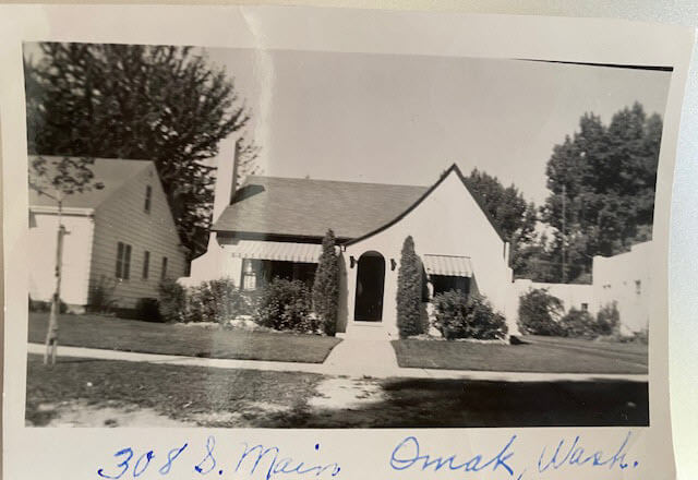
Cynthia Owens is a regular viewer and participant in the Live chat each week during Elevenses with Lisa. She emailed this photo and wrote “This picture was with my mother’s belongings…photo of a house in Omak, Okanogan, Washington with only an address written on it. 308 S. Main, Omak, WA. I have hundreds of photo’s (B & W) that have no information on them and a lot of people who I don’t know. I have a gold mine and no idea how to mine it.”
The house photo in Cynthia’s family collection.
Cynthia said that so far she has found the names of the last two owners in county records and some directories. She also determined that the house was built in 1928. She writes, “I have a lot of family on both sides of my parents who could have owned it.”
Formulate Your Research Question
The research question in this case boils down to: Who owned the home at 308 S. Main, Omak, WA in the 1930s?
Compile Known Family Names
We start by compiling a list of family surnames that we will be on the lookout for. These are families who are known to have lived in Washington state during that time frame.
Cynthia’s mother’s family names:
Woodhead
Patience
Cynthia’s father’s family names:
Tucker
Stubbs
Tonks
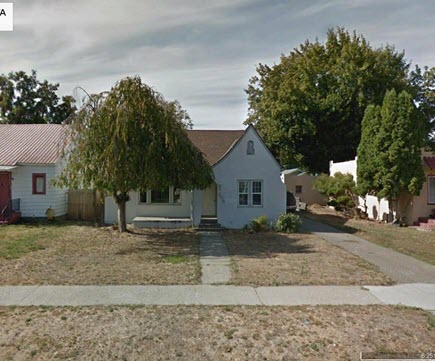
Answer the Question Does the house still exist today?
To answer this question, we turn to the free Google Earth Pro software. By simply searching the for the address and using Street View we are able to determine that yes, it is. Google Earth also allows us to obtain a high-quality image.
The house in Google Earth’s Street View today.
Google for Land Records
I conducted a simple Google search: Okanogan County Land Records
The results:
The Central Regional Branch of the Washington State Archives
“The Central Regional Branch provides archival and records management services to local government agencies throughout Benton, Chelan, Douglas, Franklin, Grant, Kittitas, Klickitat, Okanogan, and Yakima counties.”
Special Guest: Kathy Nielsen, Librarian Kathy Nielsen is a reference librarian and an educator. She has a masters degree in History and in Library Science. Kathy is currently a popular genealogy speaker on California’s Monterey Peninsula. She incorporates her skills as an historian, a storyteller and a librarian in her search for her family’s history. Kathy Nielsen stopped by to offer suggestions on obtaining land records. Watch Elevenses with Lisa episode 20 on House History featuring Kathy Nielsen.
The FamilySearch Wiki
Visit the free FamilySearch Wiki here. Search for the county in the wiki and then click on Land Records.
County Auditors Department
Where land records are located.
You can do a title search.
The records may not be online.
Email or call and inquire what the options are to access the records or have a search done.
Access varies by county.
Follow the chain of ownership back in time:
Grantee = the person who bought the property
Grantor = the person who sold the property.
Real Estate Websites
Trulia.com
Zillow.com
These sites don’t provide owner names but do show you recent transactions.
Result: The house was sold in 1997. It went on the market briefly in 2013.
Assessor’s Office (Tax Records)
These are typically only available to the current owner.
More Places to Look for Real Estate Related Information
City Directories
City directories are usually published yearly. Look also for Reverse Directories that allow you to look up the address in order to find who lived there. Kathy suggests contacting the local public library staff to inquire about City Directories and other records. Many libraries are currently staffing online reference chat.
State Libraries
Kathy recommends expanding out from the local area library to nearby communities, and the state. The Washington State Library is also currently answering questions. They have a genealogy department and city directories.
WorldCat.org
WorldCat is the world’s largest network of library content and services. The online catalog that itemizes the collections of 17,900 libraries in 123 countries and territories.
National Register of Historic Places
According to the website: “The National Register of Historic Places is the official list of the Nation’s historic places worthy of preservation. Authorized by the National Historic Preservation Act of 1966, the National Park Service’s National Register of Historic Places is part of a national program to coordinate and support public and private efforts to identify, evaluate, and protect America’s historic and archeological resource.” Click here to learn more about and search their digital database.
Department of Archaeology and Historic Preservation (Washington State)
From the website: “On this site you will find information on historic buildings, the archaeology of Washington State, how to navigate our regulatory processes and how to nominate properties to the State and National Register of Historic Places.”
Neighbors
Contacting and talking to neighbors is often one of the quickest and easiest ways to gain information. The 411.com website offers a free reverse address lookup. The results will give you the name of the current owner and residents, and even plot nearby neighbors (with names) on a map.
Researching the Home from Home
If you’re unable to research in person, make significant headway with these online resources.
Historical Societies
Google to find the official website of the historical society located in the area where the house is located. These sites may include searchable databases and information on how to contact them for resources and lookups.
Result: The Okanogan County Historical Society features a searchable database.
Facebook
Search Facebook for the name of the county historical society in the area where the house is located. Facebook pages often include more up to date information than the official website.
Old Maps
Depending on the town and area, you may be able to find an old map from the approximate time frame that includes details on homes. Two excellent free resources are:
Davidrumsey.com
Historical maps in the Layers panel of Google Earth Pro
Search at Genealogy Records Websites
Searching for various combinations of the address, town and surnames from the family tree may lead you to an answer. Here are a few examples of searches run at Ancestry.com and FamilySearch. (Your results may vary depending on the date you are searching):
Keyword: (address) 308 Main St, Omak (exact)
Results: 25 (These were not all exact)
Residence: (town) Omak (exact) and Keyword: (address) 308 Main St. (exact)
Results: 5
Search each surname in Okanogan County at Ancestry.
Results for Cynthia’s mother’s family names:
Woodhead (Paul Woodhead married in Okanogan in 1941)
Patience (No results)
Cynthia’s father’s family names:
Stubbs (results from the 1970s)
Tonks (None)
Tucker (8 results)
FamilySearch.org
Run the same at the free FamilySearch.org genealogy website. Search each surname with Omak (exact) & 1920-1940 (restricted to) U.S. On the day I searched, the only surname from the list with results was Tucker. Cynthia’s next step would be to compare the results to her known family tree.
Search the Census Specifically
You can search the census by using the search fields and using variations of names, town, county and specific address. If you don’t find the specific address that way, brown the records of the town, looking for addresses written in the left margin. At Ancestry, look for the link to a map of the location found in a census.
Results: 1930 Census: 104 West First St., Omak (Jess Tucker)
Use Google Earth to determine if the addresses found are the same today. Plot each finding on the map using placemarks.
Result: 1930 Census Address: 104 West First Street, Omak = not there today
A search in the 1940 for Jess Tucker found him still living with his mother. She was recorded as “Frances Write” living at 504 Main St., Omak, close to the house in question. When searching the census be sure to look at the pages on either side of the results page. In this case Jess is found on the next page living at “no number” as a renter at his mother’s home.
1940 Census Enumeration District Maps
Ancestry has a collection of 1940 Enumeration District Maps from the National Archives (where they can also be found here along with additional helpful search strategies.) Enumeration districts are geographic areas that were designed to allow an enumerator (the census taker) to visit every house in the district within a two-week time period. A month was allowed in more wide-spread rural areas. These maps vary in the amount of detail provided. They may or may not indicate house numbers.
Go the Ancestry Card Catalog and search for the 1940 Census Enumeration District Maps collection. In the search fields for this collection, enter the enumeration district number which can be found in the upper corner of the 1940 census page.
State Census
State Censuses were often conducted every ten years in years ending with “5” which makes them a great supplement to the U.S. Federal Census. They also sometimes include information not gathered at the federal level. Therefore, an important question to ask is “was a State Census taken in this approximate time period?”
Here’s a State Census list from the National Archives.
Results for Washington state: No state census taken after 1898.
Card Catalog Include Useful Unique Sources
Not all useful records will surface with a straight-forward search. Dig into the Card Catalog of your favorite genealogy records website to find unique and useful collections that may include addresses.
Example: Search the Ancestry card catalog for Okanogan County, WA Found: Washington, Postmaster Indexes, Prior to 1965 Strategy: Browse the alphabetically organized Okanogan cards for each family name.
Another unique record type that often includes address are Draft Cards. Search by location then surname. Also try Keyword searches. Not all cards include complete addresses but many do.
The Future is Bright
Here’s a summary of the wide variety of genealogical research strategies we’ve covered in this episode:
I really want to hear from you. Did you enjoy this episode? Do you have a question? Please leave a comment on the video page at YouTube or call and leave a voice mail at (925) 272-4021 and I just may answer it on the show!
If you enjoyed this show and learned something new, will you please share it with your friends? Thank you for your support!
Have you ever found an address for an ancestor but been disappointed that it is just a Route number and a town name? Have you wondered if it is possible to figure out where they actually lived? The good news is, it is! I’m going to show you how to take a rural “route” address from the early 20th century and find it on an old census enumeration district map.
(This article contains affiliate links for which we may be compensated. Thank you for supporting our free content.)
In a recent video I showed you how to find 1950 Census Enumeration District (ED) maps. These are super helpful and also free. In that video we used the address of an ancestor that we found by hunting through old letters and documents. But for many Americans in the early 20th century that address may have just been a route number and town.
That was the case for my viewer Lisa. She emailed me after she watched the video. She writes, “How can you find the E.D. number when you only have a Route number? My relatives lived in rural Arkansas.”
This is totally doable! Follow allow these steps of this case study and they will help you find the E.D. number and census enumeration district maps, and zero in on the location.
“Route 2” & Rural Delivery
A carrier route is basically the territory one letter carrier can cover on a daily basis. So, there could be a Route 1 or a Route 2 in thousands of places around the country. It just happens that your ancestor was on, say, Route 2 in a particular township area. Although it doesn’t tell us which house, it does dramatically narrow down the place because a daily route was the same and may not have been that large. Once we find that area we can then use other sources to help us try to get even more specific.
The first thing we need to do is gather some details. We need:
The ancestors’ names
The Route number address which includes the town
The county – which is something we can easily find online with a quick search
The year – in this case the address she has is from 1950.
So, here’s what Lisa sent me about her ancestors, the Blazers:
Names: Joseph Madison Blazer and Minnie Blazer
Route number: Route 2
Address: Frazier Pike
County: Pulaski
Joe and Minnie Blazer c1950 (Image courtesy of Lisa Egner.)
Step 2: Find the Family in the Census
Now we need to find the family in the census record closest to the date of the known address.
Since the 1950 census hasn’t been released yet because I’m recording this in Jan. of 2022, we can’t yet pull up their record. So, we’ll need to turn to the 1940 census. There’s a good chance that the family was in the same location since folks didn’t typically move around quite as much or as far as we do these days.
The 1940 census is available for free at many of the larger genealogy websites like FamilySearch and Ancestry.
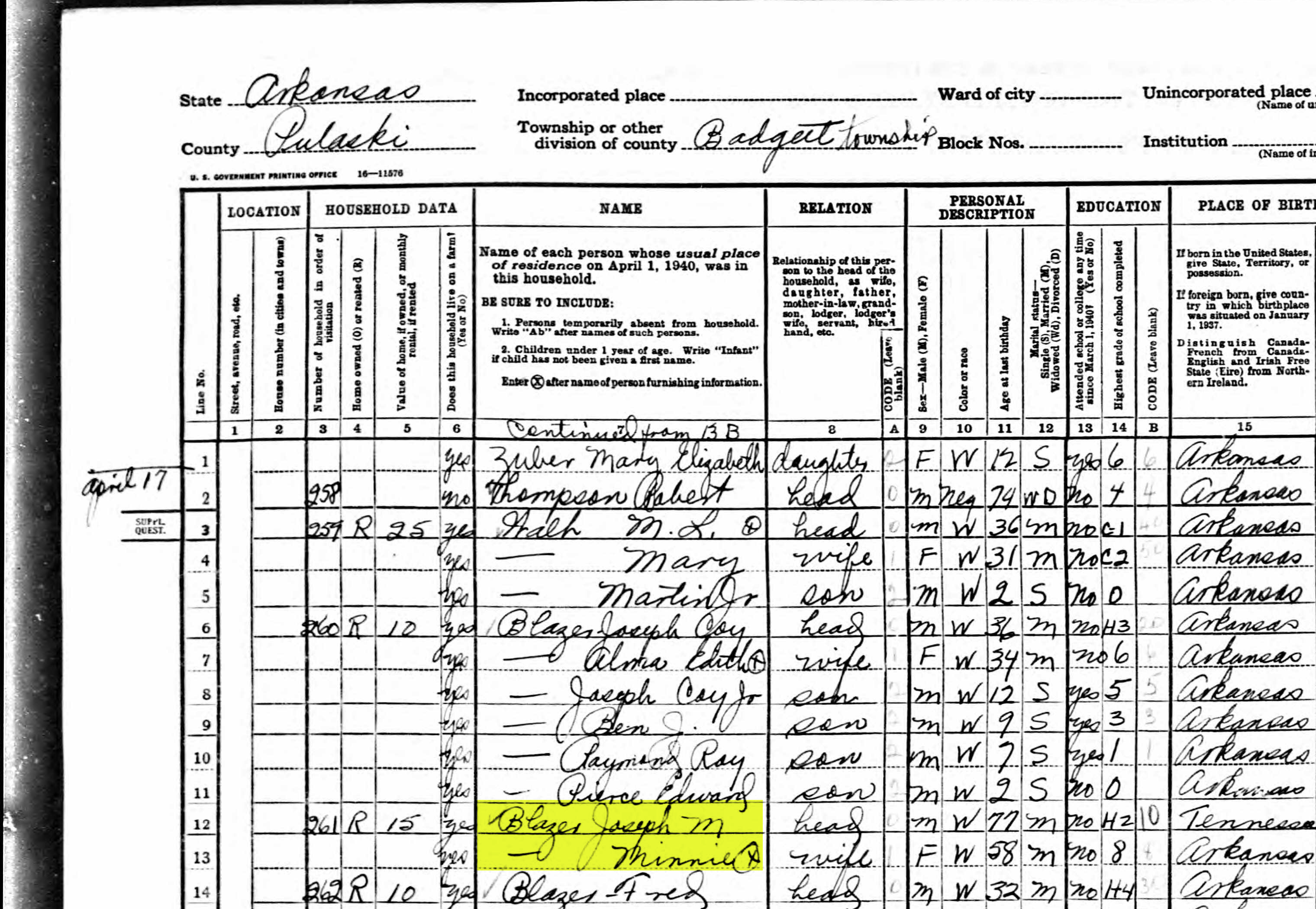
Here’s the Blazer family in the 1940 census, and Lisa confirmed that she believes this is the same place.
On the census record we are looking for three very important things:
the township (Badgett Township)
the ED number (60-2B)
and any address written along the left margin. If you don’t see anything, check the pages before and after that page. (Frazier Pike)
Step 3: Search for the Township
Once you have the location or township, search for them in an online map. I prefer to use Google Earth, but I often also use Google Maps. It doesn’t hurt to check both.
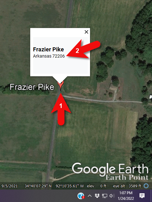
In this case we have two locations to look for: Badgett Township and Frazier Pike. We’ll start with the actual address which was Frazier Pike, Arkansas. Google Earth tell us that it’s a road just southeast of Little Rock, AR. When you click the pin it also tells you the current zip code for the Frazier Pike area, so we’ll make note of that. I’m like to create a project folder (Blazer Address) in my Places panel and then save the location pin in it. I will add additional items to the folder as I find them.
Click the pin to see the zip code.
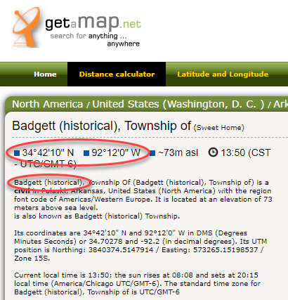
Next, I’ll search for the other location found in the 1940 census, Badgett Township. It doesn’t appear in either Google Earth or Google Maps. That’s probably because it’s been renamed or incorporated. Googling may be able to help so I googled: badgett township arkansas history.
This led me to a website that provided several helpful clues. It says that Badgett is “historical”, meaning that it’s the old name of the town which has since changed. It also provides us with the latitude and longitude of Badgett which we can use in Google Earth to confirm it’s location.
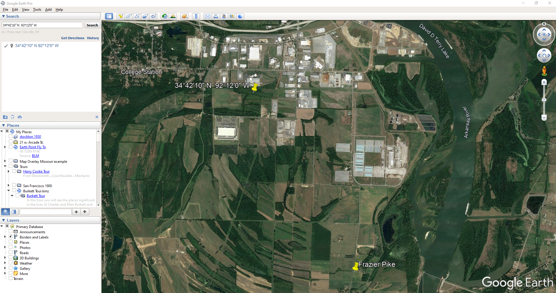
Go back to Google Earth and enter the coordinates (34°42’10” N 92°12’0″ W) in the search box and press ENTER on your keyboard.
The locations are very close.
And indeed, it’s very close to Frazier Pike. (image above)
I also like to look at the image results when googling. The website results are organized by the most relevant images. When I ran a search on Badgett, AR, and click Images on the results page, I see that the first one showed a map showing Frazier Pike. So, they are nearly one and the same.
Another search result was theHome Town Locator website. It says “the Township of Badgett (historical) is a cultural feature (civil) in Pulaski County. The primary coordinates for Township of Badgett (historical) places it within the AR 72206 ZIP Code delivery area.” This confirms that it is historical, the coordinates pin the same place on the map, and the current zip code is the same.
A quick Find on the page search (Alt + F) for Route 2 jumps me to a nice bit of history.
In the section discussing schoolhouses we get a description of the route: “…located in the main red-dirt road called Route 2 in Pulaski County. Route 2 is now known as Frazier Pike.”
Step 4: Find the ED Map for the Closest Census
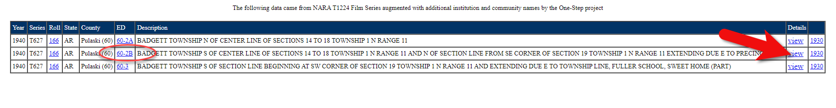
Next, we turn our attention to the enumeration district or ED number we found on the 1940 census. As you’ll recall, 1940 is the closest available census record to the date of the address, and we found Lisa’s ancestors in that record in Badgett, AR which we now know is the Frazier Pike area in Pulaski county. On that record it says: Badgett Township. ED 60-2B.
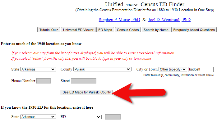
We could google for the year of the census and the words enumeration district map. However, there’s a great free tool for finding them over at Steve Morse’s One-Step Tools website at stevemorse.org.
In the menu under U.S. Census select the Unified 1880-1950 Census ED Finder, select the year at the top of the page. In this case we will select 1940. Next, enter the state (Arkansas) and county (Pulaski). You can then select the city or town. However, in the case of rural addresses, don’t expect to find the town listed. If it offers you an “Other” option you can try and type the name of the town (Badgett) in the field provided. Don’t bother entering the route number (Route 2) because that’s not a street address, it’s a postal delivery address.
We could also run this same search on the 1950 census. Chances are you will see more ED numbers listed because the population was growing. Since an enumeration district had to be the size that one enumerator could cover in about a two week timeframe, they were often redivided as they decades went by.
Since we know from the 1940 census that township was in existence, we should receive a list of ED numbers as a result. In this case we got three: 60-2A, 60-2B. and 60-3.
Click the corresponding ED number.
Click the linked ED number that matches the one you found in the census record. In this case, the 1940 census record told us that the Blazer family was in ED 60-2B, so we click that link.
The next page lists each ED. Click the View link for the ED.
Click the View link.
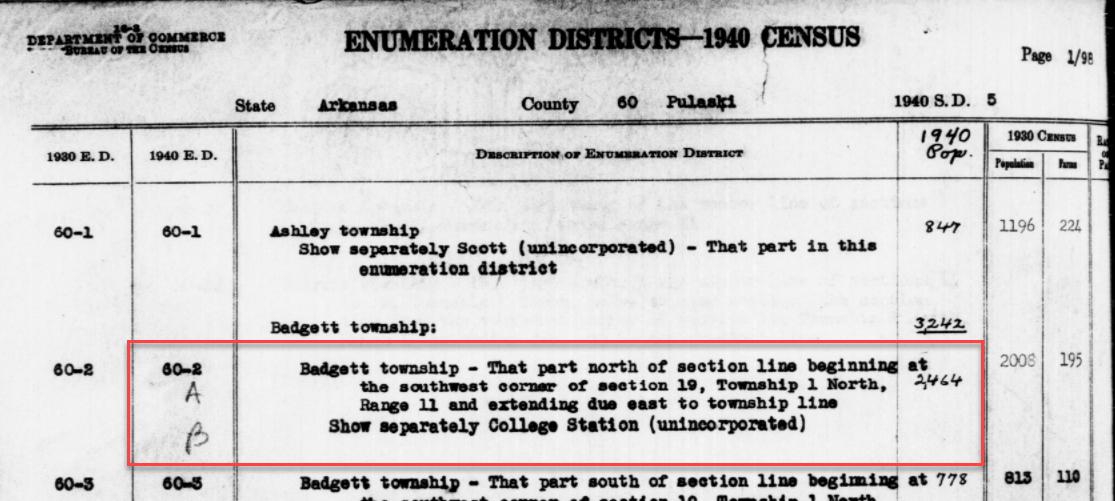
The View link will take you to the exact page for that ED in the ED Descriptions from the National Archives T1224 microfilm from Record Group 29. This description helps even further define the area.
1940 Census ED Description
60-2 A and B says, “Badgett Township – That part north of section line beginning at the southwest corner of section 19, Township 1 North, Range 11 and extending due east to township line. Show separately College Station (unincorporated.)”
This is perfect because its’ giving us the township, range and section! We can use this information to plot it in Google Earth.
How to plot a land description in Google Earth with Earthpoint:
Enter the state, principal meridian (in this case there’s only one choice here thankfully), township, range and section numbers from the census description.
Click the Fly to on Google Earth button.
This may open automatically in Google Earth or you may be prompted to save the file to your computer. Do that and then click it to open. It is a KMZ file so it will automatically open in Google Earth.
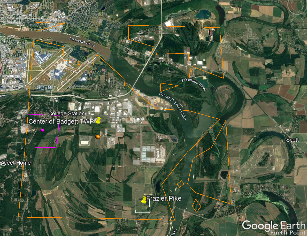
And here are the results! The location is mapped out for you.
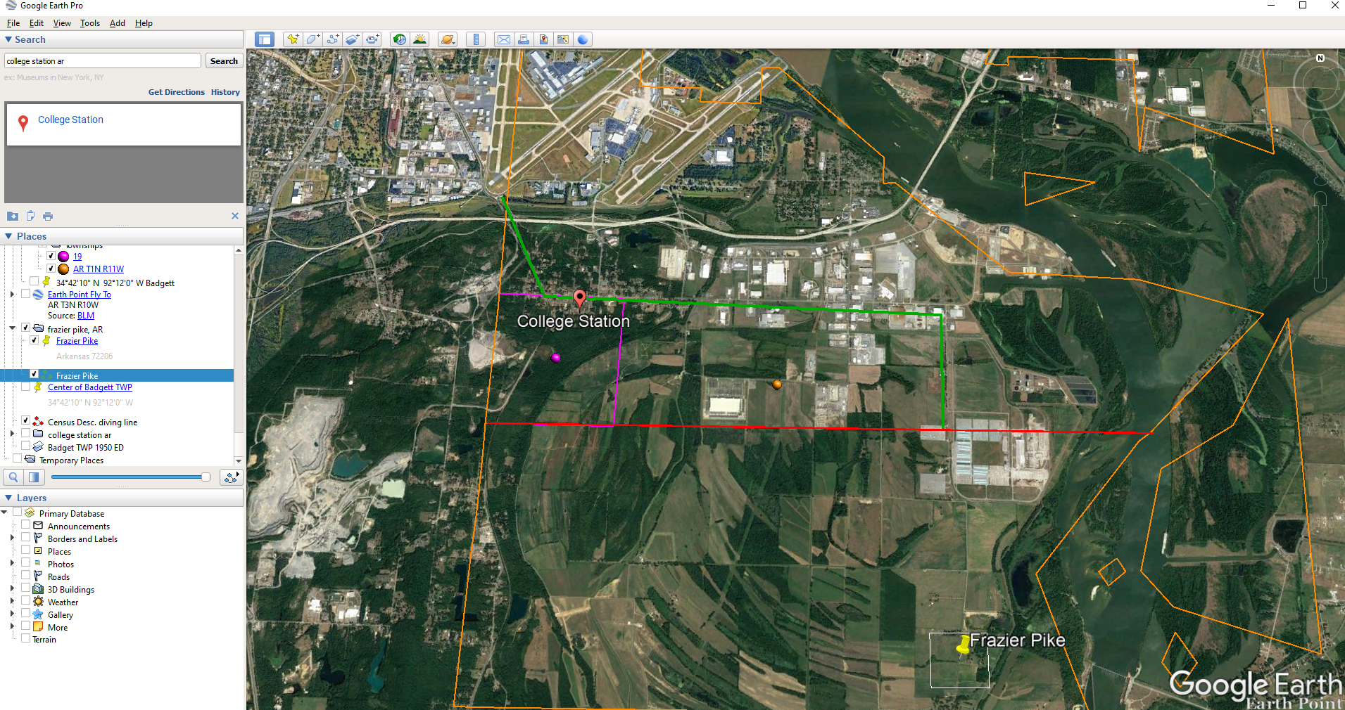
Census description mapped in Google Earth.
Notice I still have my placemark pins for the approximate location of Frazier Pike, and the center of Badgett Twp which we got using the latitude and longitude coordinates. Section 19 is outlined in purple, and the township is outlined in orange.
Since Frazier Pike is a road, turn on Roads in the Layers panel. Now we can see that Frazier Pike is running north and south and our pin is right on top of it.
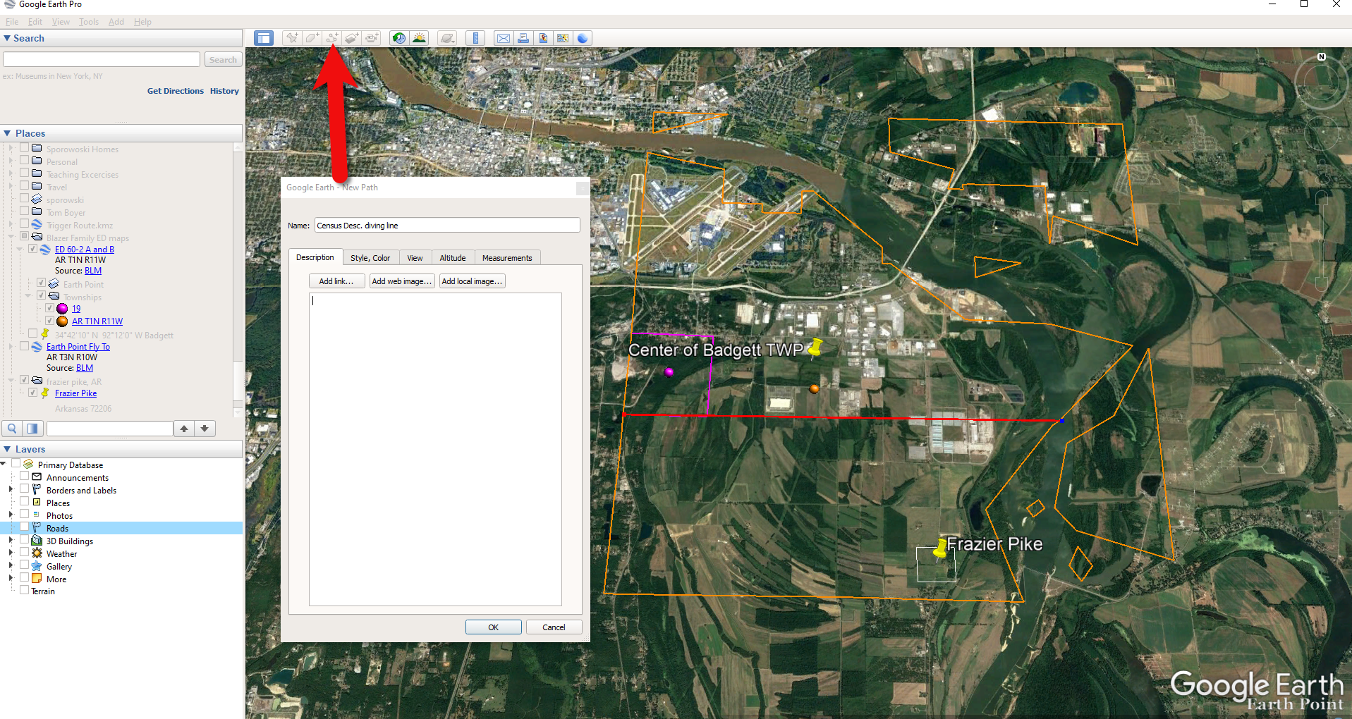
Now we can use the census description to further zero in on the area. “Badgett Township – That part north of section line beginning at the southwest corner of section 19 Township 1 North, Range 11 and extending due east to township line. Show separately College Station (unincorporated.)”
Mark that in Google Earth using the Path tool. Click the Path button in the toolbar at the top oof Google Earth. Click on the southwest corner of section 19 (outlined in purple) and then go east and click the township line (in orange.) Give your path a title and click OK.
Click the Path button in the tool bar.
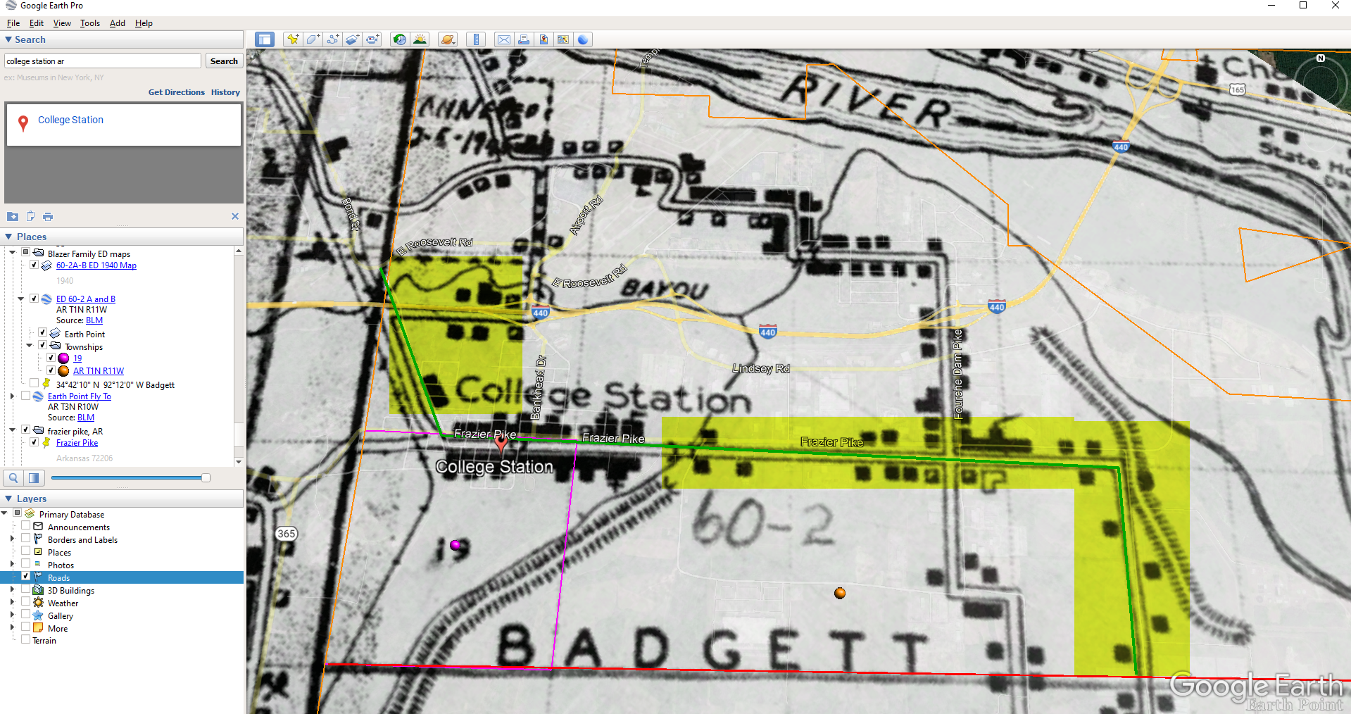
Next in the census description, on the same line as “B” it says “Show separately College Station (unincorporated.)” We can find College Park by searching for College Station, AR in the Google Earth search box.
Next, we want to follow Frazier Pike going north until we are above the section line that started in the southwest corner of Section 19. Use the Path tool again to mark it on the map.
Use the path tool to draw lines in Google Earth.
Get the Enumeration District Map
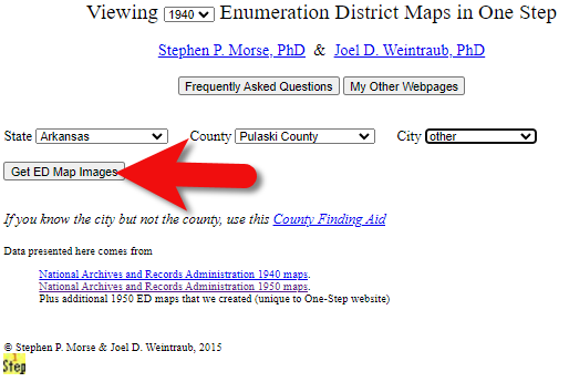
Now it’s time to head back to Steve Morse’s website and get the ED map for 1940. On the page you started your search, click the See ED Maps for… button.
Click the See ED Maps button.
On the next page select the state, county and city again and click the Get ED Map Images button.
Click the Get ED Map Images button.
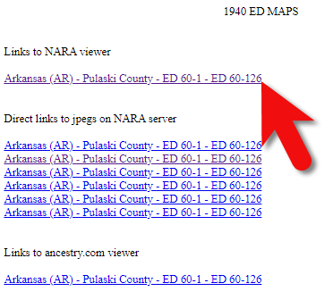
This will take you to a list of all of the available maps. The first link will take you to the National Archives webpage where you can look through all the maps for the area you selected. You could also look through all the individual maps by clicking each of the links listed under “Direct links to jpegs on NARA server”. However, I don’t recommend that will take longer because they are extremely large image files. It’s easier to quickly look through them on the NARA website.
Click the Link to NARA viewer.
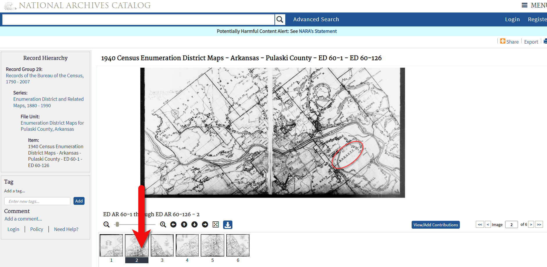
Click the link to the NARA viewer and look for the township name in the map thumbnail images. In this case I’m looking for Badgett. You can do this quickly by clicking each image and then drag the larger map in the viewer around with your mouse. I found Badgett Township in the second map.
Map images at NARA.
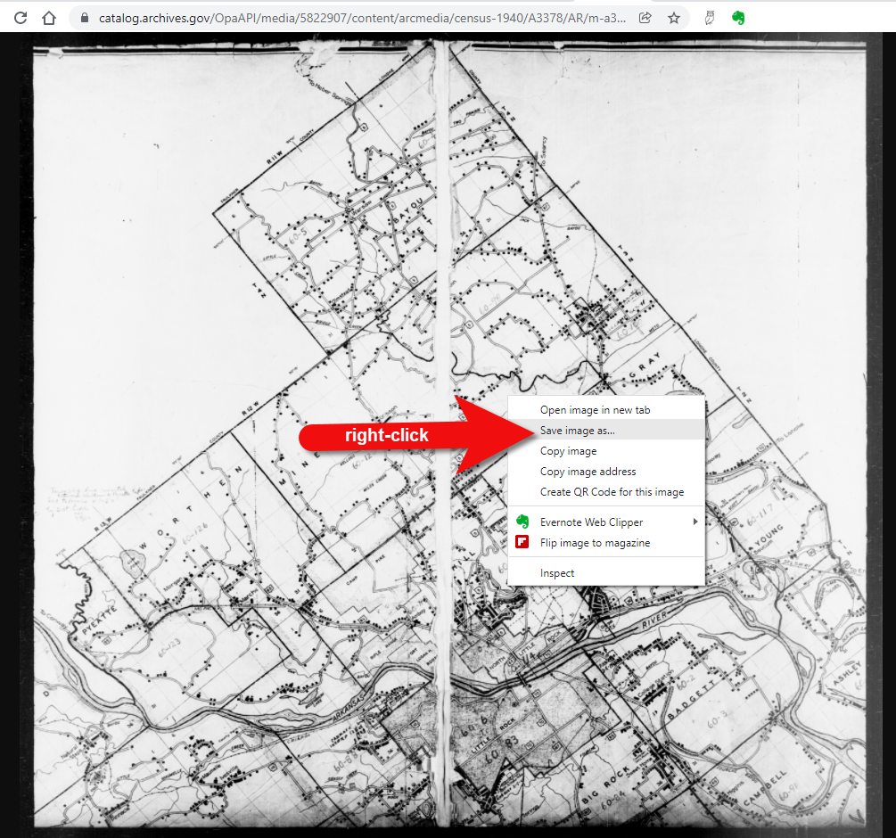
Download the full-sized map by selecting the thumbnail image and then clicking the download button (down arrow.) The full resolution map will load in your web browser. Right-click on it and Save Image As to save it to your computer.
Right-click on the map to save it to your computer.
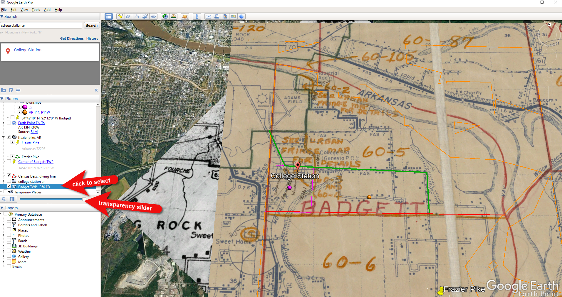
It can help to create a map overlay in Google Earth using this map. (Learn how to do this in the newest edition of my book The Genealogist’s Google Toolbox.) I cropped the image to just include Badgett Twp.
In fact, you can overlay both the 1940 and 1950 ED maps. Click to select a map in the Places panel and then you can use the transparency slide to fade it to reveal changes.
Select the map and use the opacity slider in Google Earth.
Step 5: Follow the Census
The census can provide even more clues about where in an enumeration district an address was located. Using the census record and the census description of the enumeration district, it can help to highlight the area of the map. In this case, ED 60-2 is “that part north of section line” which I marked with a red path line. The Blazers address was Frazier Pike (which I marked with a green line), so this eliminated the northern area and the Fourche Dam Pike road. To make sure that I could eliminate that area, I verified in the 1940 census that Fourche Dam Pike was enumerated separately by running a keyword search of the Pulaski County census records at Ancestry. And yes, indeed folks living along Fourche Dam Pike were enumerated separately and the road was written along the margin just as Frazier Pike was. This gives me a lot of confidence that I’m identifying the right area.
The route highlighted on the census ED map.
As you can see, there are little black squares and other markings on the map. To find out what each of those means we can turn back to the National Archives and download the page from this map collection that includes the map key.
The black squares are “Farm Units”. A farm unit square is not one family , it is the entire farm, including the owner and other families who may live and work on the farm. We also see businesses, churches, the town hall, school houses and more. We may not be able to find the exact home, but it’s possible to get very close. To do that, we need to head back to the census records themselves.
On Ancestry.com , the Blazers appear on Image 27. The filmstrip makes it easy to quickly scan through the images and browse them.
In this case, there are about 33 images or pages in ED 60-2B. The enumerator would start at one end of Frazier Pike and then make her way to the other. The enumerator wrote “College Station Pike” on pages 1 and 2. That isn’t a road today, and I couldn’t find any references to with a quick search. However, all of the other pages say, “Frazier Pike”. My guess would be that the census taker started on the west side – the hub of College Pike – and made her way east. Census enumerators visited homes and farms in a logical path, although they may have criss-crossed back and forth across the road. They listed the order in which they visited on the census form itself. In cities we might also see house numbers listed, but that’s not the case in a rural area. However, you may see pencil dots with visitation numbers written on the ED map. They were instructed to do this in rural areas in the census enumerator instructions in 1940. Unfortunately, the person enumerating 60-2B did not.
We could also look at the types of businesses and buildings shown on the map, and then look through the census records at occupations. We see a “factory/industrial” building to the east so we would look for people working in that environment in the census and see where they are living. We see a denser population in College Station along with a schoolhouse and two churches, so it would be worth looking through the census pages to see where the school teacher and pastors are listed. Folks may not have lived on the premises, but it would make sense they lived near their work.
Wedding photo Joseph Madison Blazer Minnie Mae Peters (courtesy of Lisa Egner)
And finally, we want to look for renters and owners. If a family rented, a capital “R” was entered on the census. Those who owned their property were listed with a capital “O”. Since the black squares are “Farm Units” we wouldn’t expect to see a square on the map for every house. If our hypothesis is that the enumerator started on the west side, we could count the number of owned dwellings listed in the census until we get to the family living in question. Then we would count them on the map, going east. Again, it’s not exact, but it’s a whole lot more than what we knew about the address Route 2 Frazier Pike when we started!


 About the Author: Lisa Louise Cooke