Use Google Earth for genealogy to find long-lost family locations on modern maps. Here’s how!
It can be very surprising to discover that you lived somewhere that you never knew you lived. That was the case for Professional genealogist Alvie Davidson, who recently wrote to me. He’d done some fantastic sleuthing on his own recent family history, and discovered that his family had lived in Huntsville, Alabama when he was a toddler. “This is the first I have even known they lived in Madison County, AL.” But he was not sure about how to use Google Earth to help him locate the family addresses he’d discovered.
“I have learned from the U S Government that my parents lived at (three) different addresses in Huntsville, Madison County, AL when I was a toddler in 1944….I never knew we lived in Huntsville but I learned my mother worked for munitions productions during World War II at Redstone Arsenal. She worked several months toward the end of 1944 and had to quit due to onset of pregnancy. We moved to Florida shortly after she left employment at Redstone Arsenal because we show up on the 1945 Florida State Census.”
Alvie sent me three family addresses. Then he asked for some step-by-step help instructions on how to put Google Earth to work to identify their location today.
4 Steps to Revealing More with Google Earth
1. Search each address in Google Earth. Enter the address in the search box in the upper left corner of Google Earth. If you get a hit, mark it with a placemark (clicking the button that looks like a push pin in Google Earth’s toolbar) and name it. In this case I found two of the three street addresses.
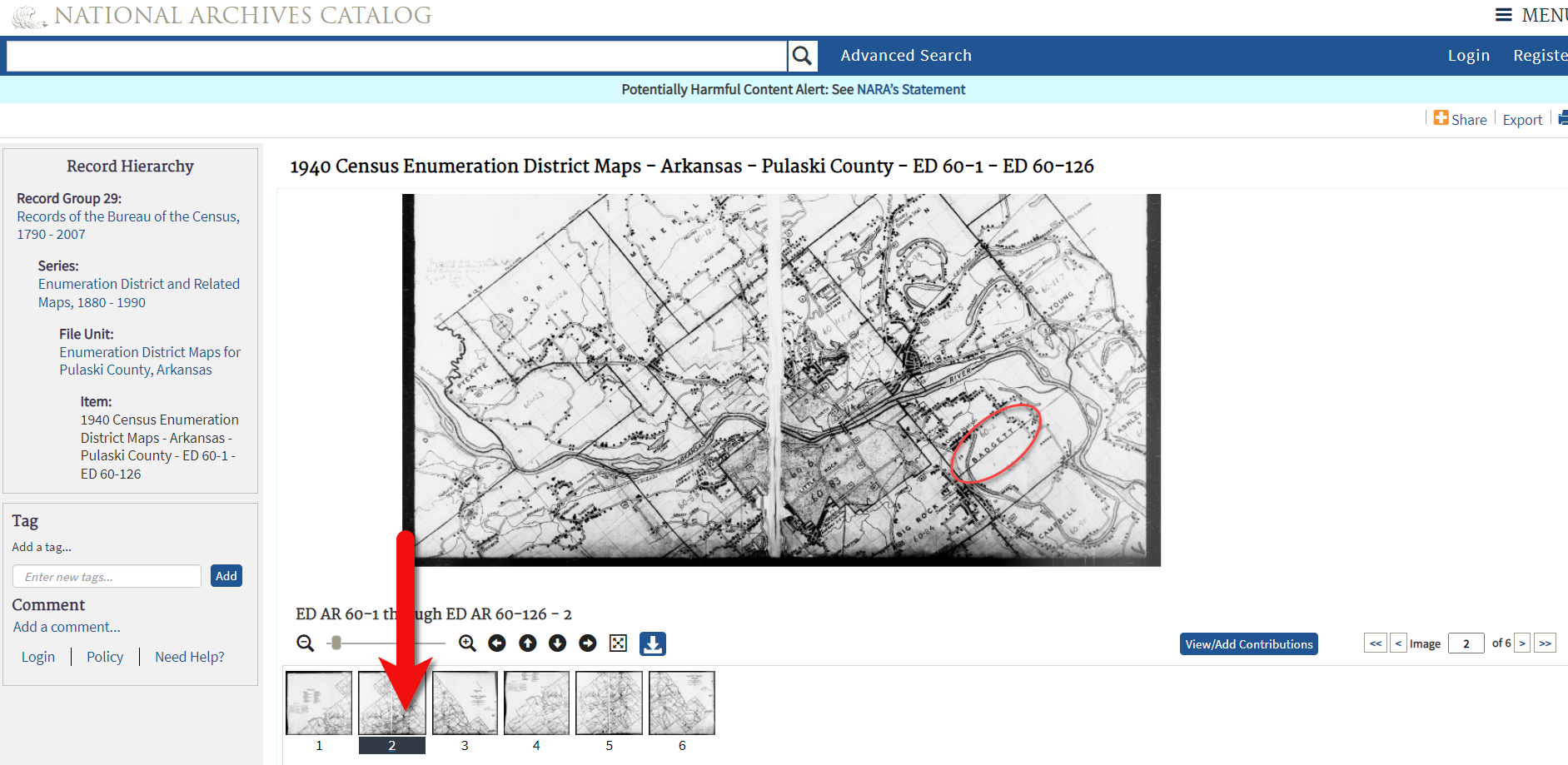
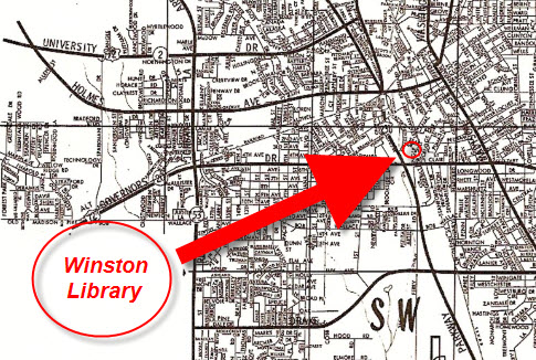
2. Locate a map of the area for the appropriate time period. With a little Google searching, I found the 1940 census enumeration map for Huntsville at the National Archives website. Here’s what that map looks like. (Image right) I then went in search of each of the three addresses on the map.
In this case, I conducted a block-by-block search of the 1940 enumeration district map for the missing address: 110 Winston Street. Unfortunately, not all the street names were clearly legible on this particular map, and I was unable to locate it.
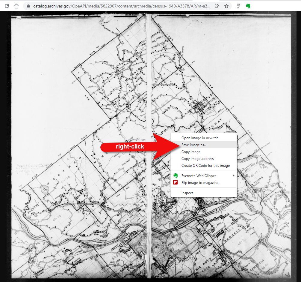
3. Overlay and georeference the enumeration district map in Google Earth to compare the past to the present.Georeference just means to match up known landmarks on the historic map with physical locations on the modern-day map, thereby allowing you to match the two maps up together. By so doing, I was able to locate on the enumeration district map the modern-day locations of the two addresses that I found using Google Earth.
There are businesses in both locations today. Below right is a screen shot showing the current location of one of those addresses. Clearly no longer the old family home.
4. Dig deeper for addresses that have changed. As I mentioned previously, I searched for the 110 Winston Street address in Google Earth with no result. If that happens to you, remove the house number and run a second search on the street name alone. Numbers can change, but it is important to verify whether the street still exists today.
In this case, Google Earth did not locate a Winston Street in Huntsville, AL. Knowing that errors and typos can happen to the best of us, I ran a quick Google search for Huntsville, AL city directories, and verified that indeed Winston Street did exist at that time in history. So, at some point between 1940 and today, the name appears to have been changed.
I headed back to Google and ran the following search query:
“winston street” “huntsville alabama”
The quotation marks tell Google that each exact phrase must appear in all search results. The phrases will appear in bold in the snippet descriptions of each result.
The result above caught my eye because it mentions the “Winston Street Branch Library.” Even when street names change, buildings named for those streets often don’t. However, in this case, the website discusses the history of the library, and the Winston Street Elementary School. According to the website, the library “became a part of the Huntsville Public Library (now Huntsville-Madison County Public Library) in 1943. In 1947, the branch was renamed the Dulcina DeBerry Library.” Perhaps the street was renamed at that time as well.
Jumping back into Google Earth I entered “Winston Street Branch Library” in the search box, and was immediately taken to the location, which is just south of the other two known addresses! At this point I would recommend to Alvie, who is a Genealogy Gems Premium Member, to watch my video class Best Websites for Finding Historical Mapsto track down additional maps from the time frame that may have Winston Street clearly marked on the map.
Once I identified this landmark, I then marked the location with a placemark. You can turn off the 1940 enumeration district map overlay by unchecking the box next to it in the Places Panel. Doing this revealed the location on the modern day map. Finally, I headed to the Layers panel and clicked the box next to the “Roads” overlay to reveal the modern day street names.
You can use this technique when you have more success than I did in finding an old address on an old map. Overlay the map, position a placemark on the location, and then turn the overlay off. With one click of the Roads layer you can now see the current street name for the old location you found on the map overlay.
Further digging online did deliver additional maps from the era and area:
We all have locations in our family history that have given way over time to new buildings and parking lots. By using the power of Google Earth, Google search, and historic maps, they don’t have to be lost forever.
Get Started with Google Earth for Genealogy
Learn all these Google skills–with step-by-step tutorials and video demonstrations–in Lisa’s book and Google Earth video tutorial. Click here for a special price on the bundle!
FREE video: Get Started with Google Earth for Genealogy
Google Bundle! The Genealogist’s Google Toolbox Second Edition PLUS learn how to create your own historical map overlays in my Google Earth for Genealogy 2-video CD set.
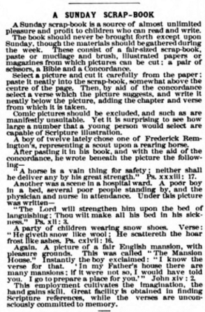
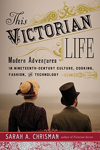
This episode’s got a bit of holiday sparkle! Lisa Louise Cooke welcomes Genealogy Gems Book Club author and Victorian lifestyle expert Sarah Chrisman to the show to talk about Victorian holiday traditions, some of which may still live on in your own life. Following that conversation, Lisa shares a fun description of Victorian-era scrapbooking: how it’s different than today’s scrapbooking hobby but also how it reminds her of modern social media.
More episode highlights:
Three success stories from Genealogy Gems listeners: a Google search with great results, a brick-wall busting marriage record and yet another YouTube find for family history (people keep telling us about those!).
Your DNA Guide Diahan Southard chimes in with what she likes so far about MyHeritage’s new DNA testing service.
An internationally-themed German research conference and a makeover for the Scotland’s People website.
The newly-relaunched ScotlandsPeople website has several exciting new features:
Mobile-friendly web design and an enhanced search function;
A quick search option for searching indexed records by name and an advanced search for specific types of records;
Free access to several records indexes;
More than 150,000 baptism entries from Scottish Presbyterian churches (other than the Old Parish Registers of the Church of Scotland) have been added and more are coming, as well as marriages and burials;
More types of records held by National Records of Scotland are coming, including records of kirk sessions and other church courts;
Explore the site for free, including handy how-to guides for using Scottish records such as statutory records, church registers and census returns.
MAILBOX: GOOGLE SEARCH SUCCESS STORY
From Joan: “I used one of the handy hints from your presentation at the South Orange County California Genealogical Society’s all day seminar in Mission Viejo, CA. I entered some of my common named ancestors, used the quotes, added a time frame and included some key words, like locations. Most of what I found were my own queries and posts. That shows it works!….
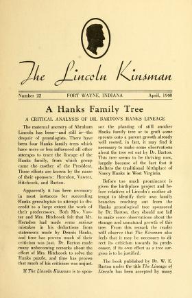
One thing I was amazed at was a multi-page article I found: ‘The Lincoln Kinsman,’ written in 1938. It included a lot of information on the Bush family [which is another of her family lines]. The article even included what I think is my ancestor Hannah Bush Radley.” (Click here or on the image above to see a copy of “The Lincoln Kinsman” at Internet Archive.)
Listen to a free 2-part series on cold-calling distant relatives or others as part of your genealogy research: “Family History: Genealogy Made Easy podcast, episodes 14 and 15.”
BONUS CONTENT for Genealogy Gems App Users:
A handy cheat sheet with 14 tips from that series on cold-contacting distant relatives. It’s updated with brand-new suggestions, including ways to find potential relatives’ names during the research process. The Genealogy Gems app is FREE in Google Play and is only $2.99 for Windows, iPhone and iPad users.
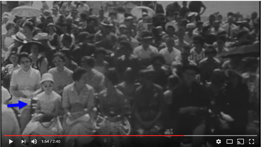
Gay entered “Freeport Texas history” in YouTube and found historical newsreel footage of the opening ceremony of a local water treatment plant. She and the women in her family were seated on the front row. Here’s a screenshot from that footage: maybe this is a stylish young Gay in sunglasses? (Watch the video here.)
Lisa Louise Cooke uses and recommends RootsMagic family history software. From within RootsMagic, you can search historical records on FamilySearch.org, Findmypast.com and MyHeritage.com. By the end of 2016, RootsMagic expects to be fully integrated with Ancestry.com, too: you’ll be able to sync your RootsMagic trees with your Ancestry.com trees and search records on the site.
Keep your family history research, photos, tree software files, videos and all other computer files safely backed up with Backblaze, the official cloud-based computer backup system for Lisa Louise Cooke’s Genealogy Gems. Learn more at http://www.backblaze.com/Lisa.
INTERVIEW: VICTORIAN CHRISTMAS WITH SARAH CHRISMAN
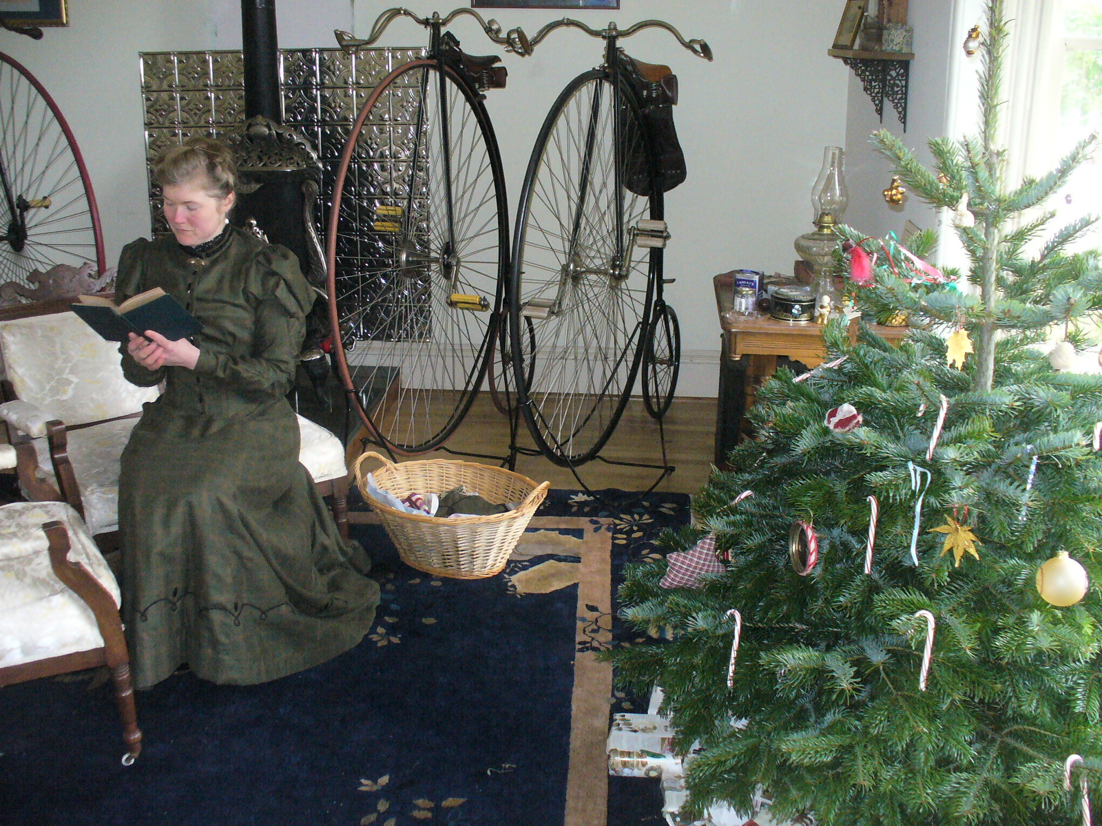
Sarah Chrisman lives her life every day as if it’s the Victorian era. Her clothing, household, pastimes, chores and more all reflect the time period.
Listen as Lisa and Sarah talk about the Victorian Christmas tree; gift-giving, crafts, decorating and things that might surprise us about holiday celebrations during that time.
First Wheel in Town: A Victorian Cycling Club Romance. This is from her series of light-hearted historical fiction set in an era she knows well!
Sarah Chrisman joins me again later this month on the Genealogy Gems Premium podcast episode 142 to talk about what it’s like to live every day like it’s the late 1800s. Don’t miss it! Not a Premium member? Click here to learn more about the perks of membership!
Legacy Tree Genealogists provides expert genealogy research service that works with your research goals, budget and schedule. The Legacy Tree Discovery package offers 3.5 hours of preliminary analysis and research recommendations: a great choice if you’ve hit a brick wall in your research and could use some expert guidance. Click here to learn more.
The Victorians coined the phrase “scrapbooking:” they literally pasted paper scraps into books. As an embellishment, those who could afford to bought “relief scraps,” such as the ones shown here. These were like the precursors of modern sticker sheets or die cuts, printed just for the scrapbooking hobby. You could buy colorful images of everything from flowers or children to animals, or angels or Father Christmas. These images were raised or embossed on the paper, which is why they called them reliefs.
Relief scraps could be used as embellishments around other items on scrapbook pages, but sometimes they were the only decoration on a page, arranged in pretty patterns.
I don’t think there is any dispute that the four major online resources for genealogy include Ancestry.com, FamilySearch.org, Find My Past, and My Heritage. Of those four, only Ancestry.com has attempted any real integration of DNA test results into traditional genealogy.
That is, until recently. On May 19, 2016 MyHeritage announced that they will be adding a DNA matching service to their offering, and then on November 7th announced they would be conducting DNA tests themselves. Now, MyHeritage has enjoyed partnerships with 23andMe and Family Tree DNA for quite some time now, but those partnerships have been woefully underutilized and are little more than an affiliate service, where MyHeritage provides a discounted rate to test at those companies.
There is no question that the launch of DNA Heritage fully into the genetic genealogy market is exciting news. In fact, it is something I have been pushing for ? we absolutely need someone to challenge AncestryDNA. Competition is good.
In September they began to provide matching results for individuals who had uploaded their results. As of today, uploading your results is still free, so if you have been thinking about it, you may want to take advantage sooner rather than later. As expected, the matches are only as good as the depth of the database, and it is early in the game, so their database is small, but even now we can get an idea of what to expect from MyHeritage as they take their first steps into genetic genealogy.
One of the most exciting elements of their November 7th announcement is their development of a Founder Population project where they have handpicked individuals to represent their reference population for calculating ethnicities. They plan to launch with 25 population groups, but will likely increase to 100 in a fairly short amount of time. This is a far more advanced ethnicity report than is currently offered anywhere else.
After you have figured out how to download your raw data from your testing company (see my instructions here: http://www.yourdnaguide.com/transferring), and then managed to add it to My Heritage (you have to add a family tree to MyHeritage to do this, see further instructions in their May press release), and waited the requisite time to process, you will receive a notice that you have new DNA matches.
For a full review of the features and ins and outs of where to click and what to look at, please refer to the September blog post from MyHeritage.
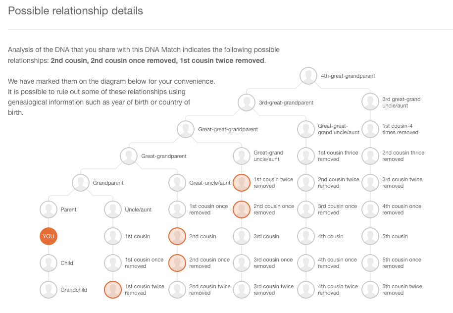
As for my favorite features, I like how they list all the possible relationships that make sense between you and your match taking into account multiple factors like your age, gender, and your genetics instead of a simple, generic range like 2nd-4th cousins. The accompanying chart that visually shows you all possible relationships is also very helpful. You can access it by clicking on the little question mark icon next to the relationship suggestions. I like that these suggestions remind us that our genetic relationships have different genealogical interpretations. Meaning that genetically, a 2nd cousin once removed, a first cousin twice removed, and a second cousin, all fall within a similar genetic range and it is impossible to determine your exact relationship based on the genetics alone.
I also like that they are providing all three genetic descriptors of your relationship: total amount of shared DNA, how many segments are shared, and the size of the longest piece of shared DNA. While this more of an intermediate to advanced piece of your results, it can be important as your relationship analysis becomes more involved.
One unique claim made by MyHeritage in their press release about their matching feature addresses a main concern that genetic genealogists have: the lack of pedigree information provided by their matches. MyHeritage claims that 95% of their DNA samples have pedigrees attached. That is remarkable! However, from my own quick calculation of my matches, the number with pedigrees is more like 60%.
They also indicated that they will soon be doing a bit of pedigree analysis for you by providing a list of shared surnames and locations between you and your match based on the pedigrees you have both submitted. This will certainly be a welcome addition.
According to the November 9th Q and A they haven’t decided yet if the ethnicity features will be available to those who only transfer, and they hint at many more features they have in the works that may only be offered to those who purchase their test.
In short, the MyHeritage site is currently functioning much like the top three genetic genealogy sites (Ancestry, Family Tree DNA, and 23andMe) and like the free tool Gedmatch, offers a meeting place for those who have been tested at one company to meet those who have tested at another, with the added bonus of a promise of new features on the horizon.
Disclosure: This article contains affiliate links and Genealogy Gems will be compensated if you make a purchase after clicking on these links (at no additional cost to you). Thank you for supporting Genealogy Gems!
When you invest your money in a genealogy website, you want to ensure that you’re getting the most value possible. Here we share tips for getting the most out of Ancestry.com.
I noticed recently that Ancestry subscribers’ attitudes run the same gamut as attitudes of big-box retailer shoppers. Some people {heart} them unabashedly: they’ll spend hours strolling the aisles and share every great find on social media. Others dash in and grab just the items they can’t live without.
Whatever your stance toward the site, Ancestry is still the big-box retailer most genealogists need at some point. Take your cue from top big-box store shopping strategies for getting the most out of Ancestry.com:
1. Grab first what you can’t get anywhere else.
Learn what exactly you want from Ancestry versus other sites, the same way you’ve learned whose house brand of spaghetti sauce you like and who carries your favorite protein bars.
A few examples for U.S. researchers:
Ancestry has the most U.S. census non-population schedules online. (They’ve padded HeritageQuest Online with several of these but they didn’t give them everything.)
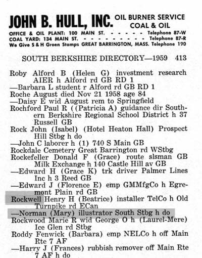
Ancestry’s collection of digitized U.S. city directories (over a BILLION) is second to none.
Beloved illustrator Norman Rockwell in a city directory. (Massachusetts Berkshire 1959 Berkshire, Massachusetts, City Directory, 1959)
2. Stock Up on Items that are Easy to Reach
While your subscription is active, stock up on easy to find items.
One way to do that is with Ancestry’s hints. Ancestry’s hinting system taps the most popular Ancestry collections (about the top 10% of the most popular collections). Watch your Ancestry tree for hints and check them all. When you first log in, note whether anyone new has taken an interest in your tree (if it’s public)–and see if they are relatives worth contacting.
We also update you regularly on new records collections that go online throughout the genealogy world: Ancestry databases are often among them.
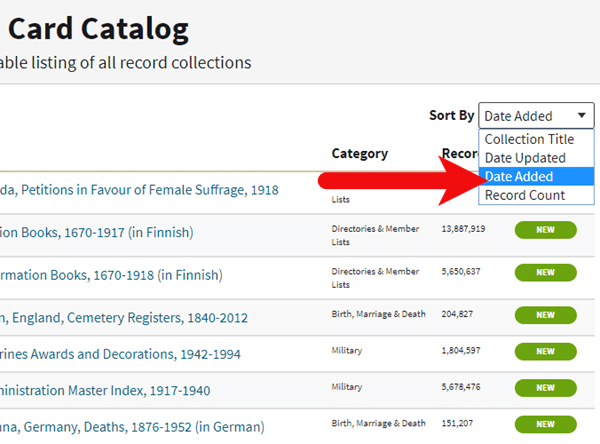
You can also sort by “Date Added” in Ancestry.com Card Catalog. This is a great way to see the collections most recently added. Look for the green “NEW” tag.
4. Avoid the Parts of the Experience that are Frustrating
Those who hate battling lines avoid big stores on peak shopping days and during the after-work rush. I avoid returning things at certain stores because their customer service desk is not worth the hassle.
Similarly, if the way Ancestry handles photos, sources, or Life Story timelines drives you nuts, ignore as much as you can except for your direct ancestors and closest relatives.
Have you ever found an address for an ancestor but been disappointed that it is just a Route number and a town name? Have you wondered if it is possible to figure out where they actually lived? The good news is, it is! I’m going to show you how to take a rural “route” address from the early 20th century and find it on an old census enumeration district map.
(This article contains affiliate links for which we may be compensated. Thank you for supporting our free content.)
In a recent video I showed you how to find 1950 Census Enumeration District (ED) maps. These are super helpful and also free. In that video we used the address of an ancestor that we found by hunting through old letters and documents. But for many Americans in the early 20th century that address may have just been a route number and town.
That was the case for my viewer Lisa. She emailed me after she watched the video. She writes, “How can you find the E.D. number when you only have a Route number? My relatives lived in rural Arkansas.”
This is totally doable! Follow allow these steps of this case study and they will help you find the E.D. number and census enumeration district maps, and zero in on the location.
“Route 2” & Rural Delivery
A carrier route is basically the territory one letter carrier can cover on a daily basis. So, there could be a Route 1 or a Route 2 in thousands of places around the country. It just happens that your ancestor was on, say, Route 2 in a particular township area. Although it doesn’t tell us which house, it does dramatically narrow down the place because a daily route was the same and may not have been that large. Once we find that area we can then use other sources to help us try to get even more specific.
The first thing we need to do is gather some details. We need:
The ancestors’ names
The Route number address which includes the town
The county – which is something we can easily find online with a quick search
The year – in this case the address she has is from 1950.
So, here’s what Lisa sent me about her ancestors, the Blazers:
Names: Joseph Madison Blazer and Minnie Blazer
Route number: Route 2
Address: Frazier Pike
County: Pulaski
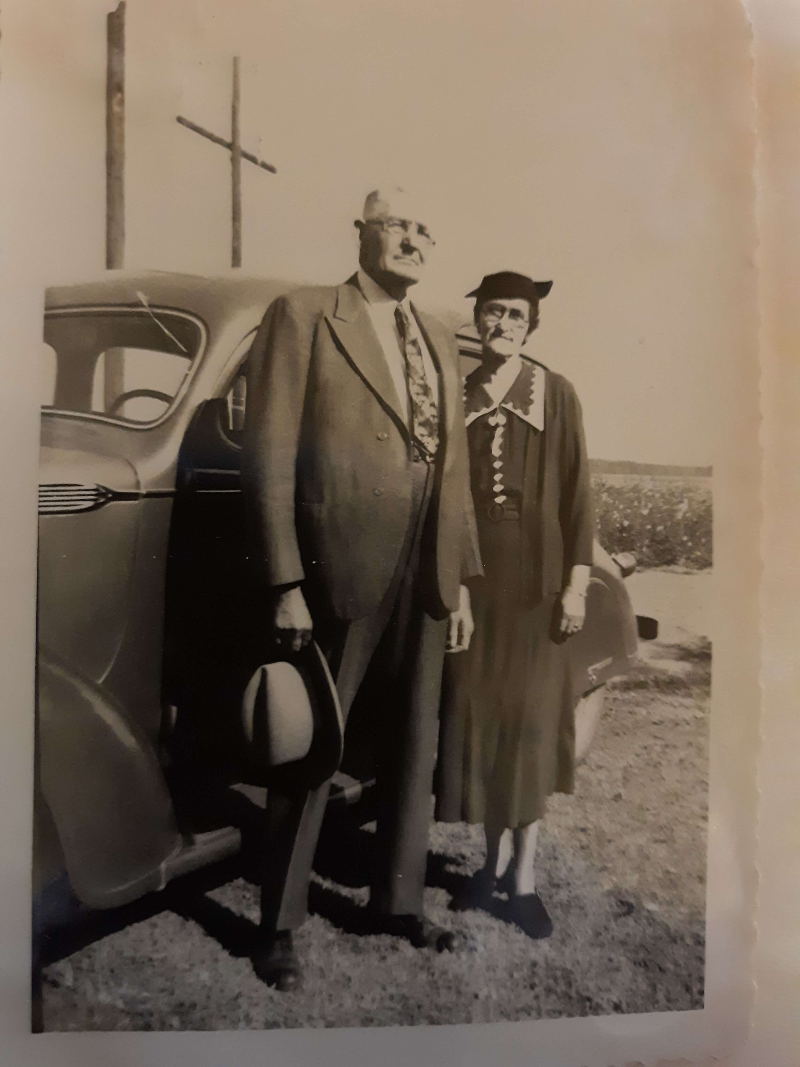
Joe and Minnie Blazer c1950 (Image courtesy of Lisa Egner.)
Step 2: Find the Family in the Census
Now we need to find the family in the census record closest to the date of the known address.
Since the 1950 census hasn’t been released yet because I’m recording this in Jan. of 2022, we can’t yet pull up their record. So, we’ll need to turn to the 1940 census. There’s a good chance that the family was in the same location since folks didn’t typically move around quite as much or as far as we do these days.
The 1940 census is available for free at many of the larger genealogy websites like FamilySearch and Ancestry.
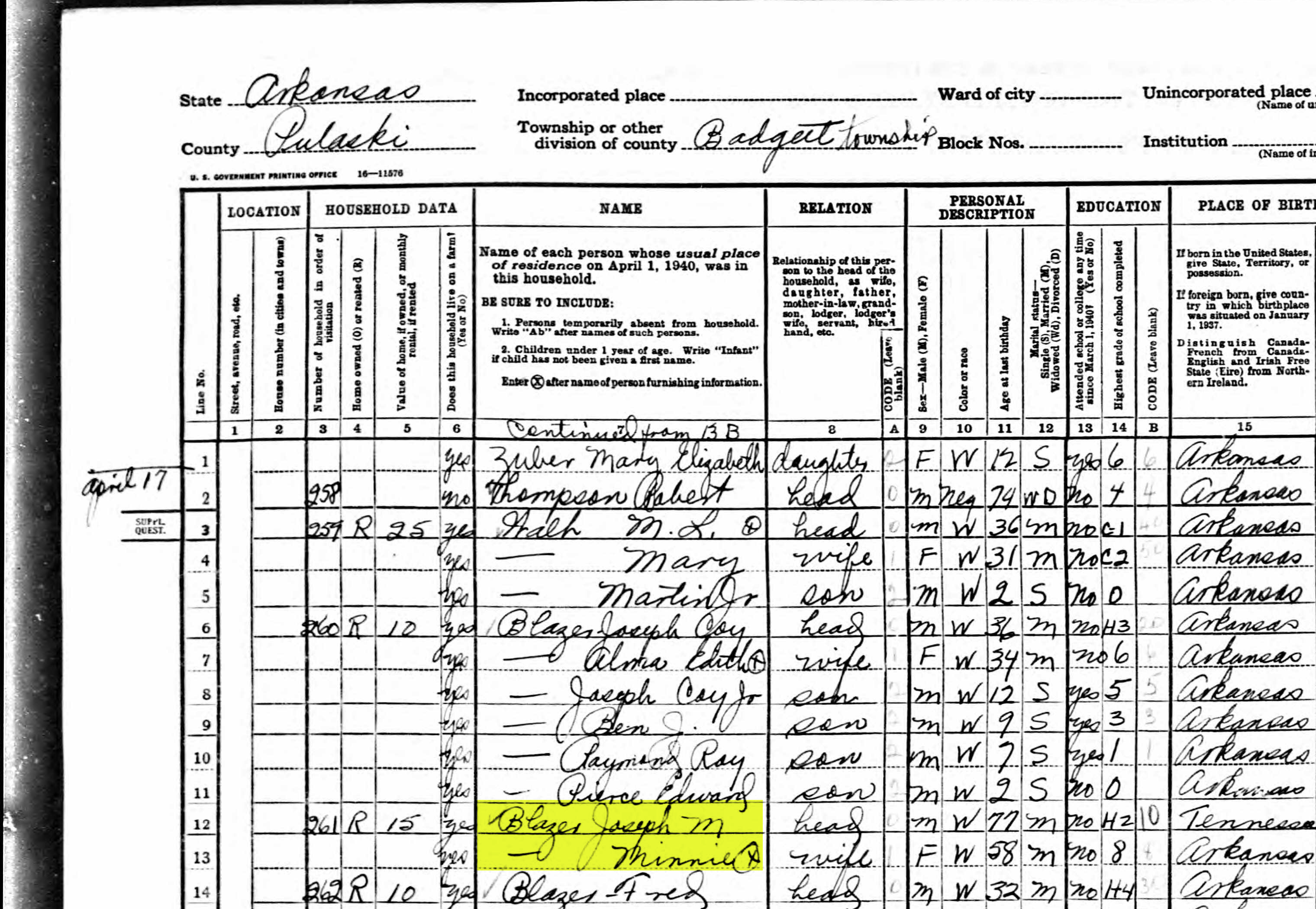
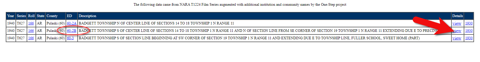
Here’s the Blazer family in the 1940 census, and Lisa confirmed that she believes this is the same place.
On the census record we are looking for three very important things:
the township (Badgett Township)
the ED number (60-2B)
and any address written along the left margin. If you don’t see anything, check the pages before and after that page. (Frazier Pike)
Step 3: Search for the Township
Once you have the location or township, search for them in an online map. I prefer to use Google Earth, but I often also use Google Maps. It doesn’t hurt to check both.
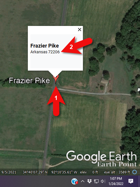
In this case we have two locations to look for: Badgett Township and Frazier Pike. We’ll start with the actual address which was Frazier Pike, Arkansas. Google Earth tell us that it’s a road just southeast of Little Rock, AR. When you click the pin it also tells you the current zip code for the Frazier Pike area, so we’ll make note of that. I’m like to create a project folder (Blazer Address) in my Places panel and then save the location pin in it. I will add additional items to the folder as I find them.
Click the pin to see the zip code.
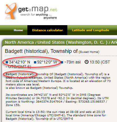
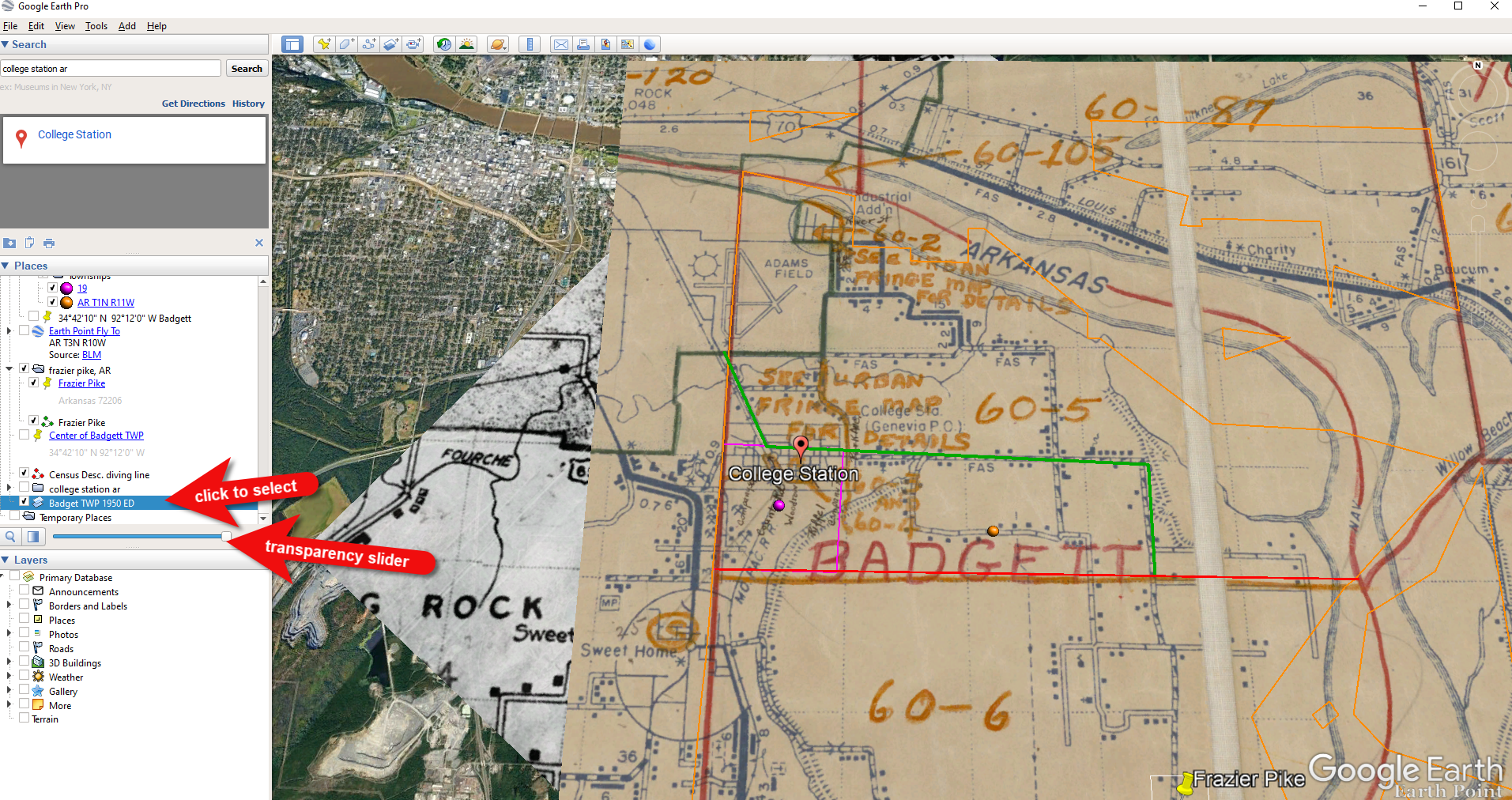
Next, I’ll search for the other location found in the 1940 census, Badgett Township. It doesn’t appear in either Google Earth or Google Maps. That’s probably because it’s been renamed or incorporated. Googling may be able to help so I googled: badgett township arkansas history.
This led me to a website that provided several helpful clues. It says that Badgett is “historical”, meaning that it’s the old name of the town which has since changed. It also provides us with the latitude and longitude of Badgett which we can use in Google Earth to confirm it’s location.
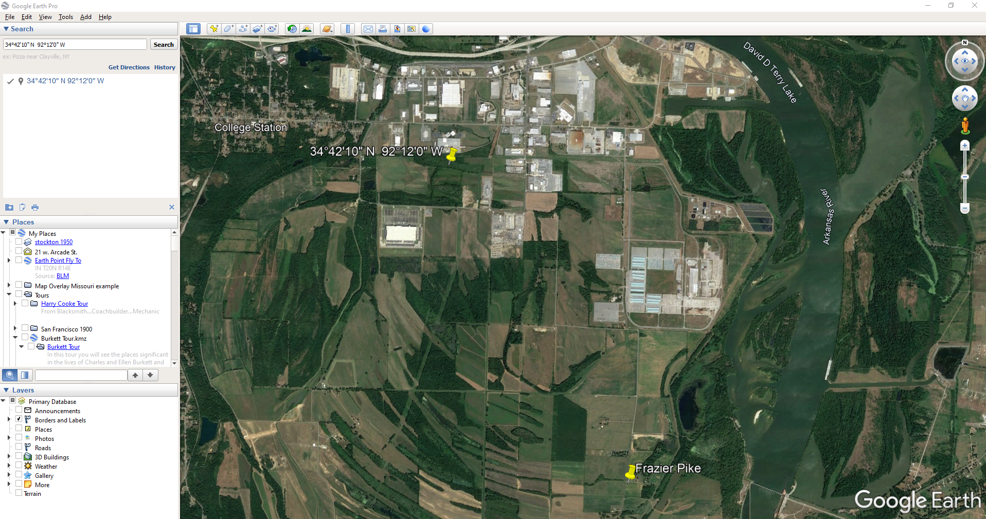
Go back to Google Earth and enter the coordinates (34°42’10” N 92°12’0″ W) in the search box and press ENTER on your keyboard.
The locations are very close.
And indeed, it’s very close to Frazier Pike. (image above)
I also like to look at the image results when googling. The website results are organized by the most relevant images. When I ran a search on Badgett, AR, and click Images on the results page, I see that the first one showed a map showing Frazier Pike. So, they are nearly one and the same.
Another search result was theHome Town Locator website. It says “the Township of Badgett (historical) is a cultural feature (civil) in Pulaski County. The primary coordinates for Township of Badgett (historical) places it within the AR 72206 ZIP Code delivery area.” This confirms that it is historical, the coordinates pin the same place on the map, and the current zip code is the same.
A quick Find on the page search (Alt + F) for Route 2 jumps me to a nice bit of history.
In the section discussing schoolhouses we get a description of the route: “…located in the main red-dirt road called Route 2 in Pulaski County. Route 2 is now known as Frazier Pike.”
Step 4: Find the ED Map for the Closest Census
Next, we turn our attention to the enumeration district or ED number we found on the 1940 census. As you’ll recall, 1940 is the closest available census record to the date of the address, and we found Lisa’s ancestors in that record in Badgett, AR which we now know is the Frazier Pike area in Pulaski county. On that record it says: Badgett Township. ED 60-2B.
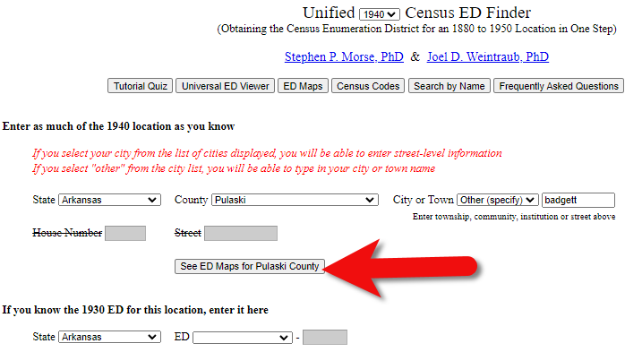
We could google for the year of the census and the words enumeration district map. However, there’s a great free tool for finding them over at Steve Morse’s One-Step Tools website at stevemorse.org.
In the menu under U.S. Census select the Unified 1880-1950 Census ED Finder, select the year at the top of the page. In this case we will select 1940. Next, enter the state (Arkansas) and county (Pulaski). You can then select the city or town. However, in the case of rural addresses, don’t expect to find the town listed. If it offers you an “Other” option you can try and type the name of the town (Badgett) in the field provided. Don’t bother entering the route number (Route 2) because that’s not a street address, it’s a postal delivery address.
We could also run this same search on the 1950 census. Chances are you will see more ED numbers listed because the population was growing. Since an enumeration district had to be the size that one enumerator could cover in about a two week timeframe, they were often redivided as they decades went by.
Since we know from the 1940 census that township was in existence, we should receive a list of ED numbers as a result. In this case we got three: 60-2A, 60-2B. and 60-3.
Click the corresponding ED number.
Click the linked ED number that matches the one you found in the census record. In this case, the 1940 census record told us that the Blazer family was in ED 60-2B, so we click that link.
The next page lists each ED. Click the View link for the ED.
Click the View link.
The View link will take you to the exact page for that ED in the ED Descriptions from the National Archives T1224 microfilm from Record Group 29. This description helps even further define the area.
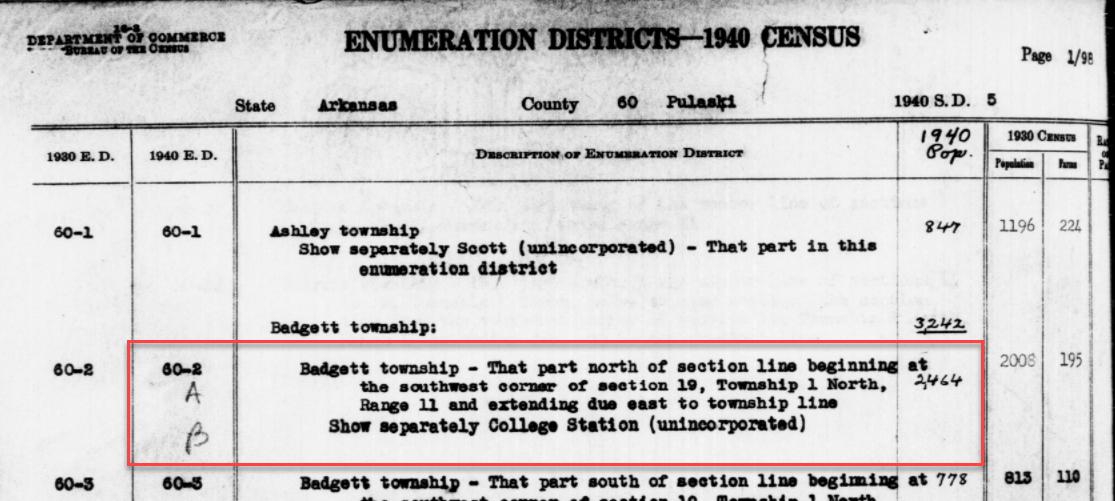
1940 Census ED Description
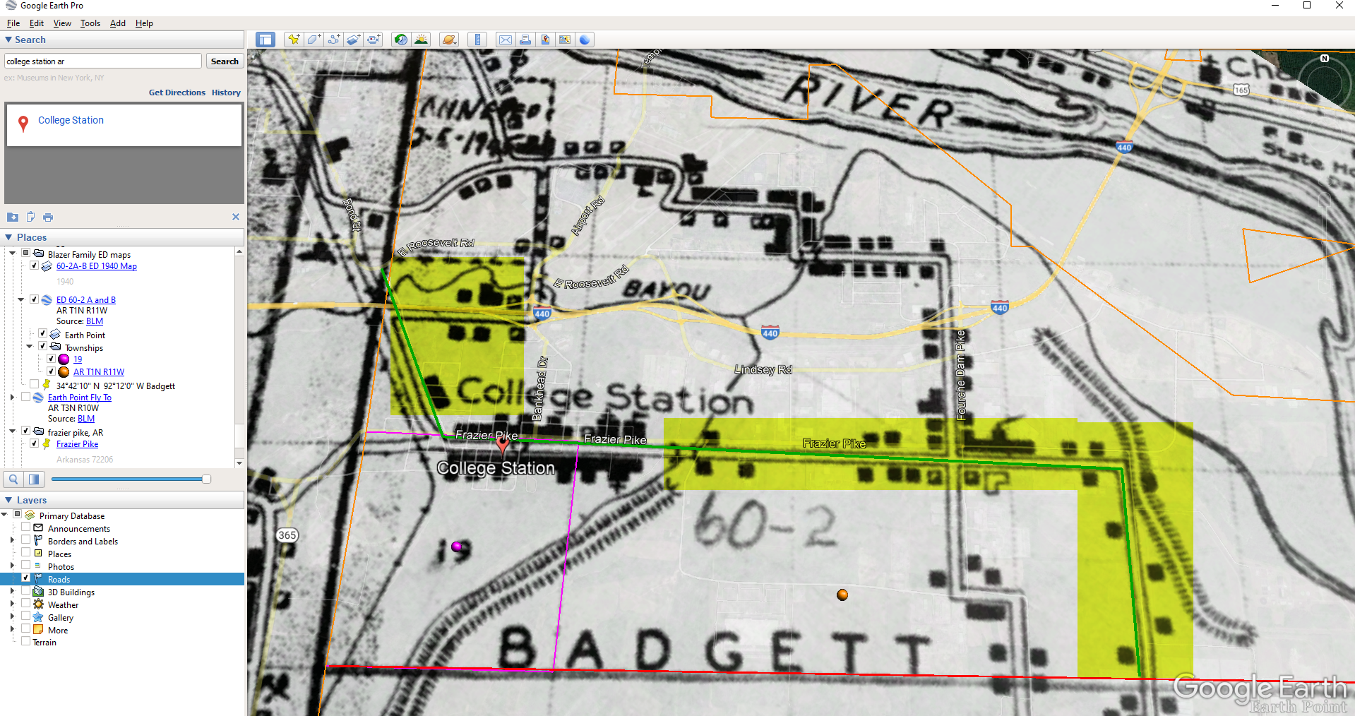
60-2 A and B says, “Badgett Township – That part north of section line beginning at the southwest corner of section 19, Township 1 North, Range 11 and extending due east to township line. Show separately College Station (unincorporated.)”
This is perfect because its’ giving us the township, range and section! We can use this information to plot it in Google Earth.
How to plot a land description in Google Earth with Earthpoint:
Enter the state, principal meridian (in this case there’s only one choice here thankfully), township, range and section numbers from the census description.
Click the Fly to on Google Earth button.
This may open automatically in Google Earth or you may be prompted to save the file to your computer. Do that and then click it to open. It is a KMZ file so it will automatically open in Google Earth.
And here are the results! The location is mapped out for you.
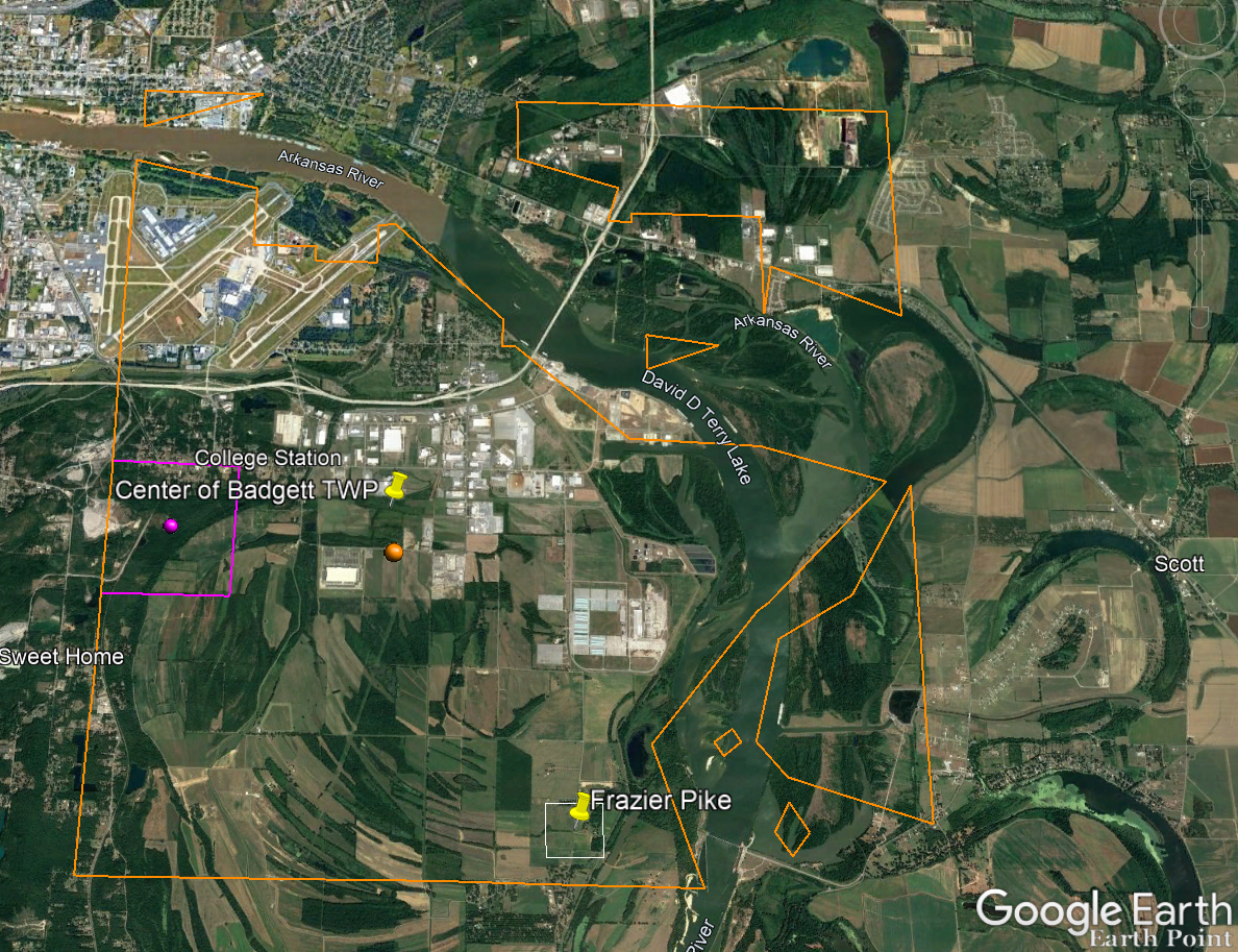
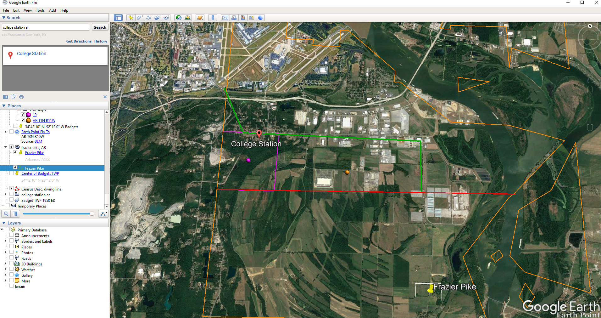
Census description mapped in Google Earth.
Notice I still have my placemark pins for the approximate location of Frazier Pike, and the center of Badgett Twp which we got using the latitude and longitude coordinates. Section 19 is outlined in purple, and the township is outlined in orange.
Since Frazier Pike is a road, turn on Roads in the Layers panel. Now we can see that Frazier Pike is running north and south and our pin is right on top of it.
Now we can use the census description to further zero in on the area. “Badgett Township – That part north of section line beginning at the southwest corner of section 19 Township 1 North, Range 11 and extending due east to township line. Show separately College Station (unincorporated.)”
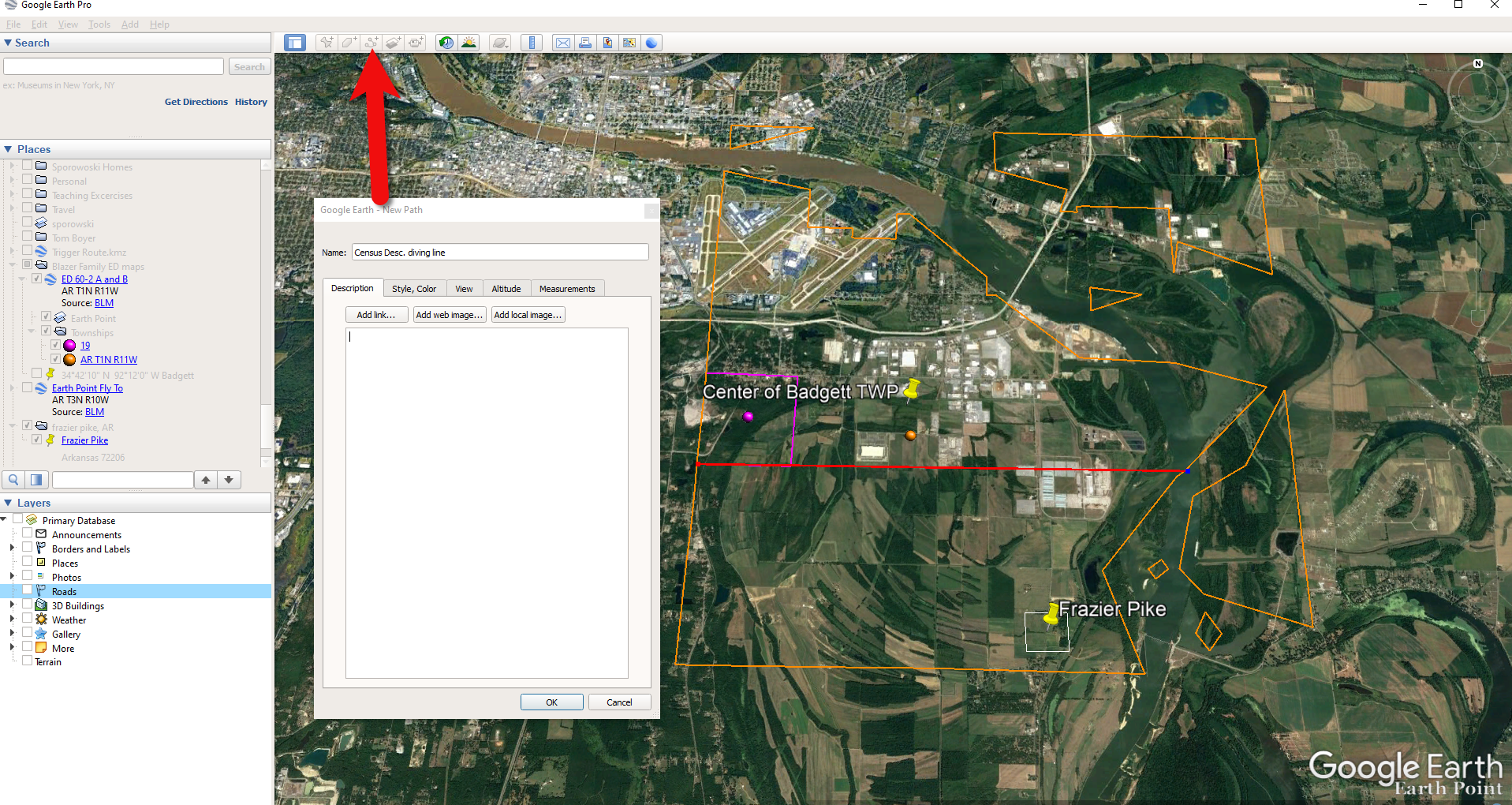
Mark that in Google Earth using the Path tool. Click the Path button in the toolbar at the top oof Google Earth. Click on the southwest corner of section 19 (outlined in purple) and then go east and click the township line (in orange.) Give your path a title and click OK.
Click the Path button in the tool bar.
Next in the census description, on the same line as “B” it says “Show separately College Station (unincorporated.)” We can find College Park by searching for College Station, AR in the Google Earth search box.
Next, we want to follow Frazier Pike going north until we are above the section line that started in the southwest corner of Section 19. Use the Path tool again to mark it on the map.
Use the path tool to draw lines in Google Earth.
Get the Enumeration District Map
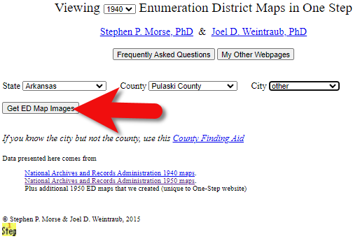
Now it’s time to head back to Steve Morse’s website and get the ED map for 1940. On the page you started your search, click the See ED Maps for… button.
Click the See ED Maps button.
On the next page select the state, county and city again and click the Get ED Map Images button.
Click the Get ED Map Images button.
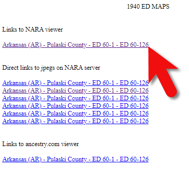
This will take you to a list of all of the available maps. The first link will take you to the National Archives webpage where you can look through all the maps for the area you selected. You could also look through all the individual maps by clicking each of the links listed under “Direct links to jpegs on NARA server”. However, I don’t recommend that will take longer because they are extremely large image files. It’s easier to quickly look through them on the NARA website.
Click the Link to NARA viewer.
Click the link to the NARA viewer and look for the township name in the map thumbnail images. In this case I’m looking for Badgett. You can do this quickly by clicking each image and then drag the larger map in the viewer around with your mouse. I found Badgett Township in the second map.
Map images at NARA.
Download the full-sized map by selecting the thumbnail image and then clicking the download button (down arrow.) The full resolution map will load in your web browser. Right-click on it and Save Image As to save it to your computer.
Right-click on the map to save it to your computer.
It can help to create a map overlay in Google Earth using this map. (Learn how to do this in the newest edition of my book The Genealogist’s Google Toolbox.) I cropped the image to just include Badgett Twp.
In fact, you can overlay both the 1940 and 1950 ED maps. Click to select a map in the Places panel and then you can use the transparency slide to fade it to reveal changes.
Select the map and use the opacity slider in Google Earth.
Step 5: Follow the Census
The census can provide even more clues about where in an enumeration district an address was located. Using the census record and the census description of the enumeration district, it can help to highlight the area of the map. In this case, ED 60-2 is “that part north of section line” which I marked with a red path line. The Blazers address was Frazier Pike (which I marked with a green line), so this eliminated the northern area and the Fourche Dam Pike road. To make sure that I could eliminate that area, I verified in the 1940 census that Fourche Dam Pike was enumerated separately by running a keyword search of the Pulaski County census records at Ancestry. And yes, indeed folks living along Fourche Dam Pike were enumerated separately and the road was written along the margin just as Frazier Pike was. This gives me a lot of confidence that I’m identifying the right area.
The route highlighted on the census ED map.
As you can see, there are little black squares and other markings on the map. To find out what each of those means we can turn back to the National Archives and download the page from this map collection that includes the map key.
The black squares are “Farm Units”. A farm unit square is not one family , it is the entire farm, including the owner and other families who may live and work on the farm. We also see businesses, churches, the town hall, school houses and more. We may not be able to find the exact home, but it’s possible to get very close. To do that, we need to head back to the census records themselves.
On Ancestry.com , the Blazers appear on Image 27. The filmstrip makes it easy to quickly scan through the images and browse them.
In this case, there are about 33 images or pages in ED 60-2B. The enumerator would start at one end of Frazier Pike and then make her way to the other. The enumerator wrote “College Station Pike” on pages 1 and 2. That isn’t a road today, and I couldn’t find any references to with a quick search. However, all of the other pages say, “Frazier Pike”. My guess would be that the census taker started on the west side – the hub of College Pike – and made her way east. Census enumerators visited homes and farms in a logical path, although they may have criss-crossed back and forth across the road. They listed the order in which they visited on the census form itself. In cities we might also see house numbers listed, but that’s not the case in a rural area. However, you may see pencil dots with visitation numbers written on the ED map. They were instructed to do this in rural areas in the census enumerator instructions in 1940. Unfortunately, the person enumerating 60-2B did not.
We could also look at the types of businesses and buildings shown on the map, and then look through the census records at occupations. We see a “factory/industrial” building to the east so we would look for people working in that environment in the census and see where they are living. We see a denser population in College Station along with a schoolhouse and two churches, so it would be worth looking through the census pages to see where the school teacher and pastors are listed. Folks may not have lived on the premises, but it would make sense they lived near their work.
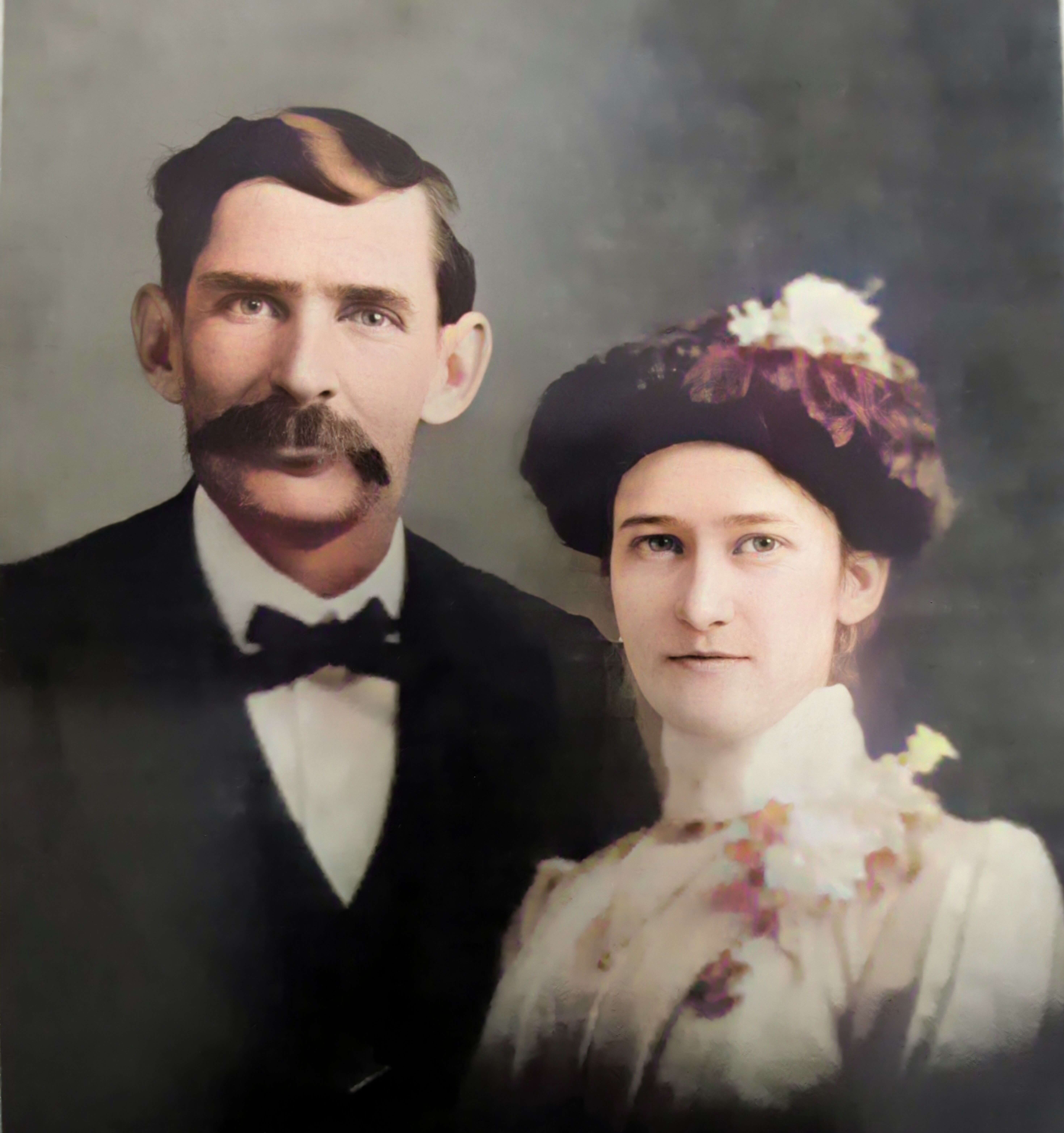
Wedding photo Joseph Madison Blazer Minnie Mae Peters (courtesy of Lisa Egner)
And finally, we want to look for renters and owners. If a family rented, a capital “R” was entered on the census. Those who owned their property were listed with a capital “O”. Since the black squares are “Farm Units” we wouldn’t expect to see a square on the map for every house. If our hypothesis is that the enumerator started on the west side, we could count the number of owned dwellings listed in the census until we get to the family living in question. Then we would count them on the map, going east. Again, it’s not exact, but it’s a whole lot more than what we knew about the address Route 2 Frazier Pike when we started!


 First Wheel in Town