Map of Hollywood, 1928. Online at David Rumsey Historical Map Collection. Click on the map for full citation information.
Pictorial maps are both fun and useful for finding our family history. These use illustrations in addition to regular cartographic images to communicate their messages.
For example, this 1928 map of Hollywood, California, inserts faces of the famous and illustrations of local attractions. But maps like those don’t just exist for popular tourist destinations. And now there are even more pictorial maps online and FREE to use at the David Rumsey Map Collection.
According to a press release, “Over 2,000 pictorial maps and related images have been added…in the form of separate maps, pocket maps, case maps, atlases, manuscript maps, and wall maps.” These include “certain panoramic and birds-eye maps, diagrammatic maps, and timelines.” Pictorial maps were especially popular during the 1920s-1940s, but David Rumsey includes many from the 19th century and before. The collection continues to grow; check back often to look for the maps you want most.
Did you know that I teach an entire video class on using historical maps in genealogy research? I’ve put a free excerpt on the Genealogy Gems YouTube Channel: Using Sanborn Fire Maps for Genealogy and Family History. Watch it below! Genealogy Gems Premium members can watch the full class, which goes in-depth on four MORE types of helpful historical maps, and download the companion handout! (Click here to learn more about Premium membership.)
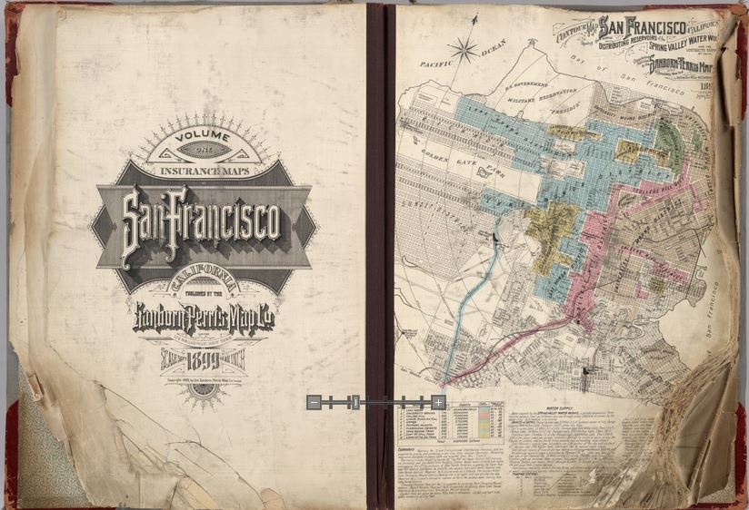
Opening pages of rare 1905 Sanborn Map of San Francisco, showing city just before 1906 earthquake. Find the entire map book at the David Rumsey Historical Map Collection
Genealogists rely on historical maps to help us navigate the geography of our ancestors’ lives. One of the most important resources available online is the David Rumsey Map Collection. Well, Rumsey recently announced on his website that he will be making more than 38,000 of his historical maps–everything he’s currently got online–available at the Digital Public Library of America (DPLA).
I blogged recently about the DPLA, which aims to create an enormous, free digital library we can all access online. It will be great to have the Rumsey map collection searchable on the DPLA so we can search these maps while we look for any other sources on any particular location our ancestors lived. “Maps tell stories that complement texts, images, and other resources found in the growing DPLA library,” says Rumsey. “And the open content policies of my online library fit perfectly with DPLA’s mission to make cultural resources freely available to all.” He applauds what the DPLA is trying to accomplish and even encourages other collectors to donate content.
Rumsey has spent years collecting thousands of old maps and putting them online. Now he’s working to share them even more widely. His entire collection of about 150,000 maps will eventually be housed at Stanford University. Meanwhile, we can all enjoy the thousands of images we can search on his site or at the DPLA.
Google’s free program Google Earth includes nearly 150 historic maps in the Layers panel. You can also add historic maps downloaded from Rumsey’s site to Google Earth by using the Overlay feature. My video tutorial series called Google Earth for Genealogy will show you how. You can also get step-by-step instructions in my book The Genealogist’s Google Toolbox. Or get them all in a discounted bundle.
Imperial Airways Map of Empire & European Air by Laszlo Moholy-Nagy, 1937. Online at DavidRumseyHistoricalMaps.com. Click on the image to see full citation information.
Among more than 15,000 maps and images newly posted at the David Rumsey Map Collection, these caught my eye as particularly useful for family history. Do any of them look relevant to YOUR genealogy?
1. A massive group of German Invasion plans for England, Wales, and Ireland in WWII;
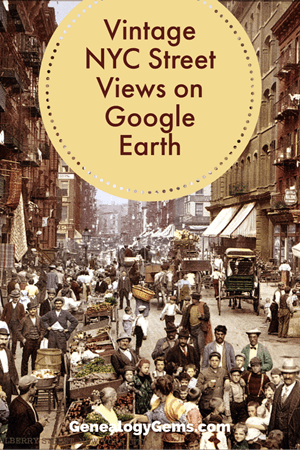
You can now see New York City street views from the late 1800s and early 1900s as Google Earth street views. Take a virtual visit to the Big Apple as it was 100 years ago! Or travel back even further in time to an 1836 map of NYC conveniently overlaid on a modern Google Earth view. These are just two of the many ways to use Google Earth for genealogy—and for fun.
Vintage New York City Street Views on Google Earth
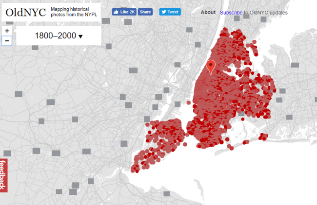
Over 80,000 original photos from the late 1800s and early 1900s have been mapped into Google Earth to provide what’s essentially a Google Street View map of old New York City!
As you can see from this overview map (below), the old photos are concentrated in the areas of Staten Island, Brooklyn, Queens and Lower and Upper Manhattan. Dots represents historic photos that have been overlaid on Google Earth’s modern map (satellite view is also available).
Old NYC
You can zoom in to click on individual dots, which will bring up one or more individual photos of certain neighborhoods or street fronts:
Select the photos that match up best with your family history interests, such as a shot of your family’s old store front or apartment building. Or choose images that represent the time period in which your relatives lived in the area, so you can get a flavor of what their neighborhood would have looked like. (Click here for some ideas about where to look for your family’s exact address during the late 1800s or early 1900s.)
According to this article at BusinessInsider.com, a developer Dan Vanderkam worked with the New York Public Library to plot all the photos onto Google Earth. (A hat-tip to Genealogy Gems listener and reader Jennifer, who sent me this article because she knows how much I love old maps and data visualization!)
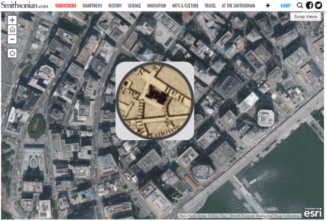
Another Old NYC Street View: 1836 Map
While we’re on the subject, I also want to mention another cool tool for visualizing old NYC street views. At the Smithsonian.com, there’s a cool historic map overlay of an 1836 New York City map in Google Earth. Use the scrolling and zooming tools to explore the parts of NYC that were already settled–and to compare them to what’s there today. You can also swap views to see the 1836 map with just a little round window of the modern streets.
The accompanying article quotes famous map collector David Rumsey about the 1836 map, which is his. He describes how you can see that much of the topography of Manhattan has changed over the years—did you know Manhattan used to be hilly? And I love how he calls out artistic features on the old map, too.
Smithsonian NYC street view 1836
Unfortunately, the old map doesn’t show much in the way of residents’ property lines or buildings. But you can clearly see the street layouts and where the parks and hills were. Comparing these areas with Google Earth’s street view today can help you better understand what things looked like in a much older version of one of the world’s great cities.
Use Google Earth for Your Genealogy
There are so many ways to use Google Earth for genealogy! My free video class will get you started. After a quick tutorial on downloading and navigating Google Earth, see how to utilize its powerful tools to identify an old family photo, map out addresses that may have changed and even plot an old ancestral homestead.
Premium Podcast Episodes As a Genealogy Gems Premium Member you have access to the entire back catalog of Premium Episodes! Of course, things do change over time, so occasionally you’ll hear about something that is no longer around (like the Premium Message...

 Did you know that I teach an entire video class on using historical maps in genealogy research? I’ve put a free excerpt on the Genealogy Gems YouTube Channel: Using Sanborn Fire Maps for Genealogy and Family History. Watch it below! Genealogy Gems Premium members can watch the full class, which goes in-depth on four MORE types of helpful historical maps, and download the companion handout! (Click here to learn more about Premium membership.)