If you have Canadian kin, you’ll be pleased to hear that the 1825 census of Lower Canada is now searchable online, and the 1921 census will soon be available online, too!
The 1825 census of Lower Canada counted nearly half a million people. Heads of household were actually named, with other members of the household counted by category. You can search by household name or geographic location.
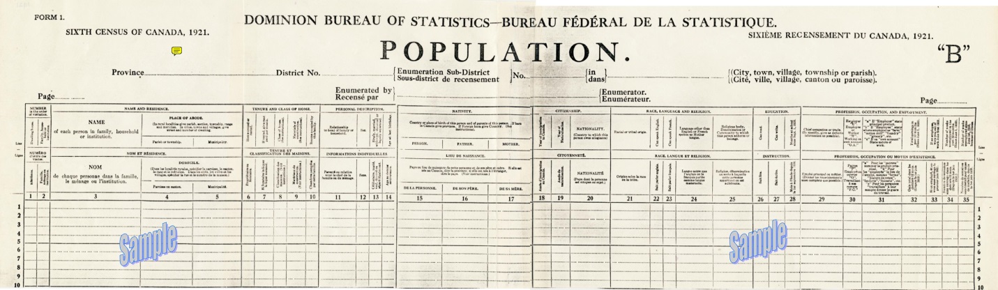
The 1921 census counted 8.8 million people in thousands of communities across Canada. According to the Library and Archives Canada Blog, the population questionnaire had 35 questions. The census also collected data on “agriculture; animals, animal products, fruits not on farms; manufacturing and trading establishments; and [a] supplemental questionnaire for persons who were blind and deaf. This represents a total of 565 questions.” The census was released this past June 1 from the national Statistics office to the Library and Archives. That office is processing and scanning the nearly 200,000 images for public use. It hopes to have them posted soon.
Here’s a sample page from the 1921 census population schedule:
We think of Canada as a real melting pot today—or salad bowl, as they prefer. That wasn’t always the case. The 1825 census of Lower Canada counted mostly Europeans of French extraction. In 1901, 70% of Canadians claimed either British or French heritage. But in the first two decades of the 1900s, a huge immigration boom occurred that reached well beyond England and France. So the folks who show up on the 1921 census represented a newly multicultural Canada!
Start looking for your Canadian ancestors in the Library and Archives Canada’s popular Census Indexes, which include that 1825 census and a new version of the 1891 census, too. Watch the website for the 1921 census.
If your family arrived in Canada after the 1921 census, check out the website for The Canadian Museum of Immigration at Pier 21, where a million immigrants landed between 1928-1971.
Show Notes: The 1931 Canadian Census was released by the Library and Archives Canada on June 1 of 2023. These digitized images can (as of now) be browsed by general location. The challenge with this census, like with other census records when they first come online, is that there is no index. Creating the index that makes the census searchable by name and other identifying factors takes a while. So right now, the digitized images are available online to browse. Ancestry.com is partnering with the Library and Archives Canada and using its artificial intelligence technology to generate the index. Until that happens, I have four strategies for you that are going to help you find your ancestors right now. And you’ll be able to find them much faster than if you just browsed the images one by one. Once the index comes out, it’s not necessarily going to be perfect. They never are. So, these strategies can help you if you run into trouble finding someone in the 1931 Canadian census. And they’ll also help you better understand the information that you do see in the images.
My first strategy for finding your ancestors in the 1931 census of Canada is to check the earlier census records. Our goal is to identify the enumeration sub-district and the municipality where they lived. If we can find it in an earlier census, we can use that information to find them more quickly in the 1931 Canadian Census.
In my case, the person I’m looking for in the 1931 Canadian census is my husband’s great-grandfather, Harry Cooke. He emigrated to Canada in 1912, along with his second wife, Martha. I started my search for them by seeing if I could find them in a census record sometime after 1912, but prior to 1931.
Harry lived in Regina, Saskatchewan. So, I was able to use the Census of Prairie Provinces that was taken in 1926 in Saskatchewan, Alberta, and Manitoba. You can use the Census Search Tool at the Library and Archives Canada website to search those census records.
If your ancestors lived in other provinces, again, that Census Search Tool is going to help you find the most recent census records available for them.
In 1926 Harry Cooke was in sub-district number 8 and the municipality was Sherwood, so I made note of that. Also, while looking at that 1926 census, I found there is an area where it talks about where each household is located. They list the Township, Range and Meridian. So, I also made note of the township number listed, which in this case was 17. If your ancestors happen to live in a city, there may be a street address listed. Though many people came to Canada to work the land, so you may not be fortunate and find that information. But make note of the street address if it’s listed. Sometimes it’s written right across the Township, Range and Meridian columns.
Strategy #2 Check City Directories for Addresses
I really easy way to look for city directories is just to google it. I found the 1931 city directory for Regina by going to Google.com and typing in 1931, Regina city directory. The very first result was the city directory for Regina in 1931 at Internet Archive. I happen to have heard that there was a directory for 1931, so that’s why I searched for it specifically. If you don’t happen to know the year you can run a Google search for a time frame. Do this by entering the name of the town or the closest big city to where your ancestors lived in the search field. Add the phrase city directory, and then enter a number range. Google calls this search operator a numrange. Here’s an example:
Regina city directory 1912..1931
This type of search brings up links to web pages that mention Regina, the words city directory, and also a four-digit number that falls within the specified range, which for us would be the year that the city directory was published!
The Internet Archive has thousands of digitized and searchable city directories. Many genealogy record websites use The Internet Archive as their cloud hosting service for their records. They digitize everything and upload it to Internet Archive where they can host it, and then link to it on their website. So that is a great place to look.
However, it’s a good idea to run a Google search because that way you are going across the internet, and hopefully you’ll find the city directories that you need.
In my case, in 1931 Harry and Martha are still at 520 Osler Street. So that reinforces what I had found in the 1926 census.
Strategy #3 Search at the Library and Archives Canada website
At the time of this writing, without an actual index, we’re going to enter the province name, the city / district if you have it, and the sub-district.
In the case of Harry and Martha Cooke, I found them in 1926 in sub-district #8, so that was the first place I searched. However, in 1931 sub-district #8 was not associated with the municipality of Sherwood. In fact, it didn’t mention township 17 either, so it was very suspicious.
It is possible that enumeration sub-districts can change over time. This can happen because as a country grows, the population grows. District lines must be redrawn in a way that allows a single census taker (enumerator) to cover the area within a certain given amount of time. In a more populated city, that can mean that the sub-district actually shrinks a little bit, and there are more sub-districts added. However, the previous sub-district does give you a great starting point. It’s very possible that the person you are looking for is in a sub-district close to the original. So, you’ll just have to browse a little further. And that takes us to strategy number four.
Strategy #4 Browse the Records Faster Using Clues
You could go through each digitized page of the 1931 Canadian census one by one looking for your relatives. That took an especially long time when the records were first released on June 1 of 2023. On my computer each image took at least two hours to load…it was crazy! But it’s not surprising, because I’m sure everybody and their brother wanted to look at these records.
Thankfully, now it’s running much faster. But it could still take quite a long time to look page by page. There are a few more things that you can do to make the process much faster.
First, as you pull up each sub-district, keep track of your search with a research log. After checking the sub-districts before and after the one Harry Cooke was in in 1926, I went back to the beginning and started with sub-district #1. The very first image in each sub-district is going to be a title card that will include the township number, and the municipality covered in that sub-district. So, since you already located that in the earlier census record, you are going to be able to immediately tell if that group of images is worth going through.
If it doesn’t match, go on to the next sub-district. This is why a research log is important. Genealogy Gems Premium Members can download the worksheet in the Resources section at the bottom of these Show Notes. It’s just a really simple way to keep track of everything that you’re finding and make sure that you’re not covering the same base twice.
You might come across a title card that has the right municipality but not the right township number, or vice versa. I found that in one case while looking for the Cookes. Just make note of it on your worksheet, and keep moving, looking for an exact match.
If you find a sub-district that looks really promising, perhaps it includes the township or the municipality you need, take a quick look at image number two. This is the first page that shows people in the neighborhood. There are a couple of things to look for.
If you know that your ancestors were British, like Harry and Martha were, then you might expect them to be in a neighborhood with predominantly British people. That was really common. When our ancestors left their homeland and came to a new country, they oftentimes emigrated with other people from the country that they knew. They may have heard about the opportunity from those people. And once they arrived, they tended to congregate together. They lived together in communities and neighborhoods because they shared a culture and language. They could support each other and help each other.
One of the things that tipped me off that sub-district #8 wasn’t the right place to be searching for the Cookes was that it was comprised primarily of Russians, Austrians, Romanians, and Hungarians. Harry and Martha didn’t speak those languages, so I would not expect them to be there. Also, when I looked at the 1926 census, I made note of who his neighbors were. And indeed, it was a very predominantly British neighborhood. So that was a clue to me that even though I might have had the right township number, it didn’t mention the right municipality, and it certainly had a completely different makeup when it came to the neighborhood.
Also, as you’re reviewing the surnames and going down the list on the image, take a look at the township column. As you’ll recall, we made note of the township number and / or the address that we found in the earlier census. As you scan the surnames on the page, also check if the correct township number or address is showing up.
In my search, I saw a lot of different street names (not Osler St.). I don’t know Regina very well, so in another browser tab, I opened up Google Maps. I did a search for 520 Osler St., and then I selected “Directions” and entered one of the street names that I was seeing on the census. And sure enough, they were miles and miles apart. That’s another clue you’re not in the right area for browsing.
Our goal is to find our relatives as quickly as possible without spending hours reviewing pages that are not likely to include them. So, again, if you don’t find that exact match of Township and Municipality on the sub-district index card, look at these other factors to see if you’re in the right ballpark.
In the end, I am happy to say I found Harry and Marth Cooke pretty quickly. They were in sub-district number 11. The title card showed that it covered township 17 and the municipality of Sherwood. It was an exact match! They were on image number 18 residing in a very predominantly British neighborhood on Osler St., exactly where I would expect them to be.
1931 Canadian Census Search Wrap Up
The 1931 Canadian Census is full of valuable information about your Canadian relatives. While it take a little more time to search without an index, these strategies can help you do so faster. You can also apply (and tweak) these techniques to other types of searches where an index is unavailable, or your relatives aren’t showing up in the search results. And remember, if you find an address, look up the location in Google Maps to see it for yourself.
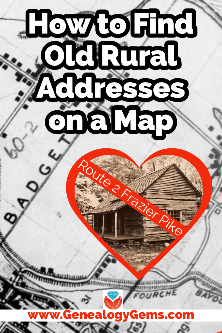
Have you ever found an address for an ancestor but been disappointed that it is just a Route number and a town name? Have you wondered if it is possible to figure out where they actually lived? The good news is, it is! I’m going to show you how to take a rural “route” address from the early 20th century and find it on an old census enumeration district map.
(This article contains affiliate links for which we may be compensated. Thank you for supporting our free content.)
In a recent video I showed you how to find 1950 Census Enumeration District (ED) maps. These are super helpful and also free. In that video we used the address of an ancestor that we found by hunting through old letters and documents. But for many Americans in the early 20th century that address may have just been a route number and town.
That was the case for my viewer Lisa. She emailed me after she watched the video. She writes, “How can you find the E.D. number when you only have a Route number? My relatives lived in rural Arkansas.”
This is totally doable! Follow allow these steps of this case study and they will help you find the E.D. number and census enumeration district maps, and zero in on the location.
“Route 2” & Rural Delivery
A carrier route is basically the territory one letter carrier can cover on a daily basis. So, there could be a Route 1 or a Route 2 in thousands of places around the country. It just happens that your ancestor was on, say, Route 2 in a particular township area. Although it doesn’t tell us which house, it does dramatically narrow down the place because a daily route was the same and may not have been that large. Once we find that area we can then use other sources to help us try to get even more specific.
The first thing we need to do is gather some details. We need:
The ancestors’ names
The Route number address which includes the town
The county – which is something we can easily find online with a quick search
The year – in this case the address she has is from 1950.
So, here’s what Lisa sent me about her ancestors, the Blazers:
Names: Joseph Madison Blazer and Minnie Blazer
Route number: Route 2
Address: Frazier Pike
County: Pulaski
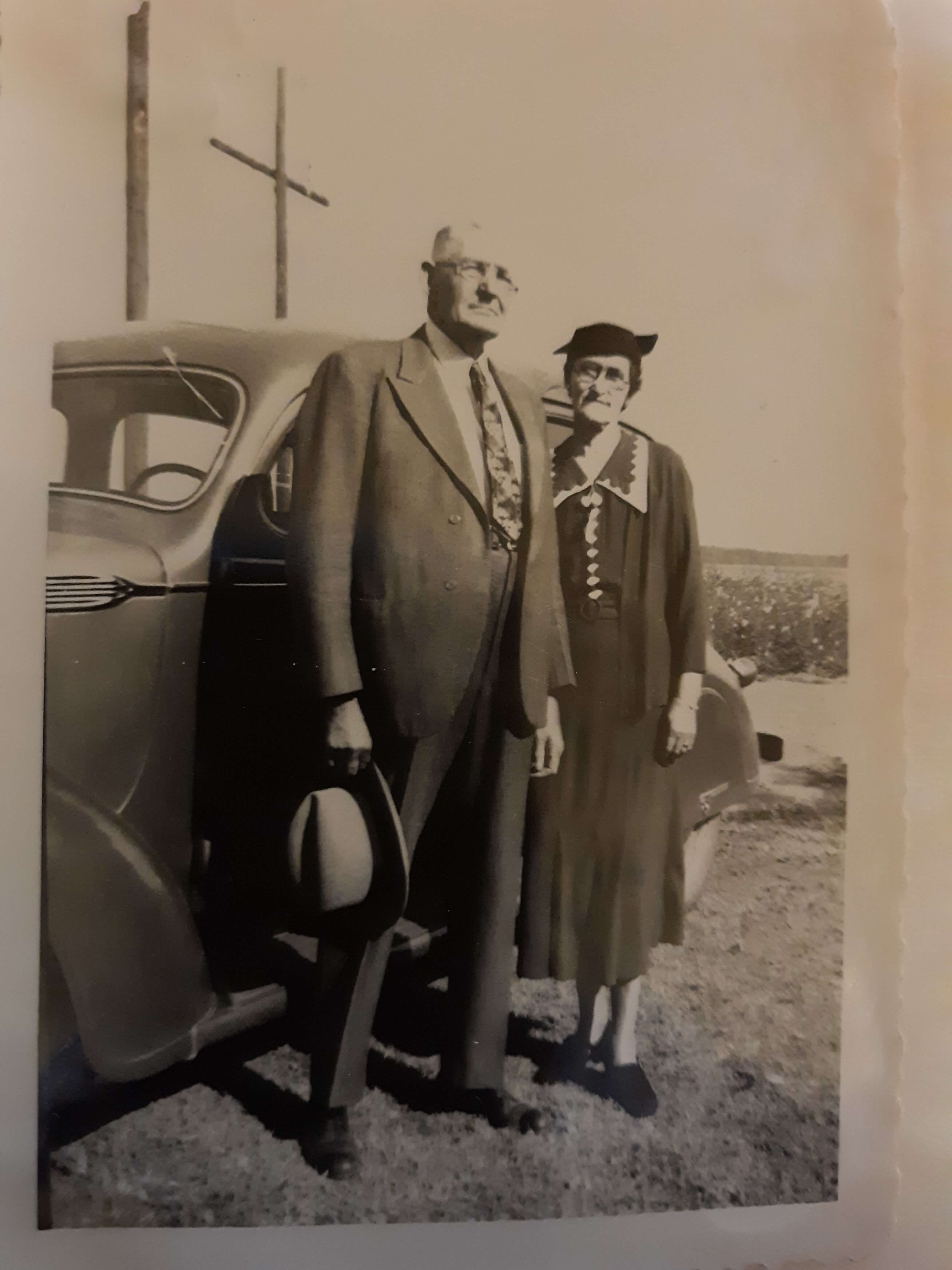
Joe and Minnie Blazer c1950 (Image courtesy of Lisa Egner.)
Step 2: Find the Family in the Census
Now we need to find the family in the census record closest to the date of the known address.
Since the 1950 census hasn’t been released yet because I’m recording this in Jan. of 2022, we can’t yet pull up their record. So, we’ll need to turn to the 1940 census. There’s a good chance that the family was in the same location since folks didn’t typically move around quite as much or as far as we do these days.
The 1940 census is available for free at many of the larger genealogy websites like FamilySearch and Ancestry.
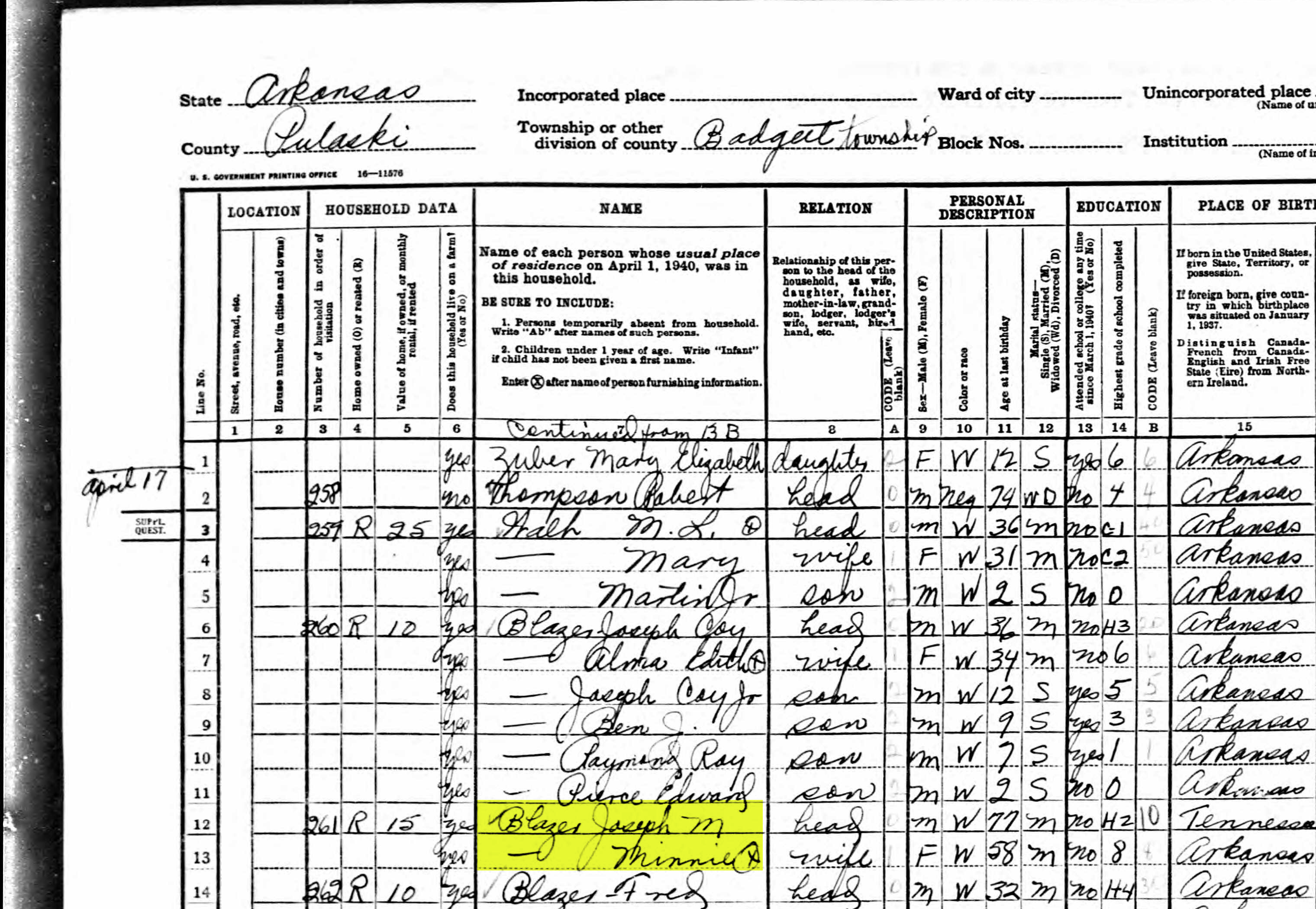
Here’s the Blazer family in the 1940 census, and Lisa confirmed that she believes this is the same place.
On the census record we are looking for three very important things:
the township (Badgett Township)
the ED number (60-2B)
and any address written along the left margin. If you don’t see anything, check the pages before and after that page. (Frazier Pike)
Step 3: Search for the Township
Once you have the location or township, search for them in an online map. I prefer to use Google Earth, but I often also use Google Maps. It doesn’t hurt to check both.
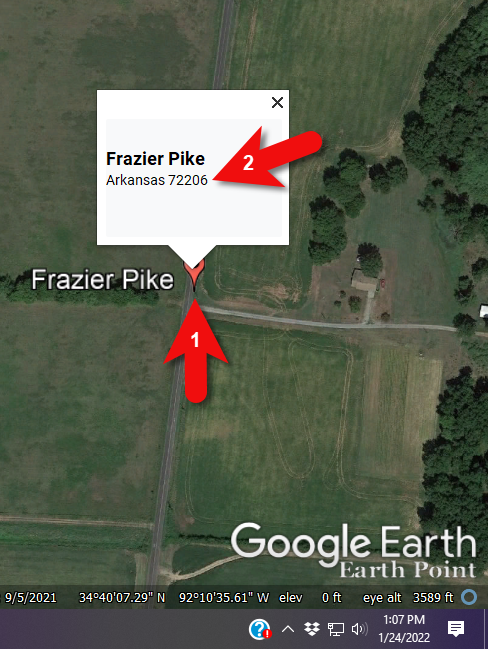
In this case we have two locations to look for: Badgett Township and Frazier Pike. We’ll start with the actual address which was Frazier Pike, Arkansas. Google Earth tell us that it’s a road just southeast of Little Rock, AR. When you click the pin it also tells you the current zip code for the Frazier Pike area, so we’ll make note of that. I’m like to create a project folder (Blazer Address) in my Places panel and then save the location pin in it. I will add additional items to the folder as I find them.
Click the pin to see the zip code.
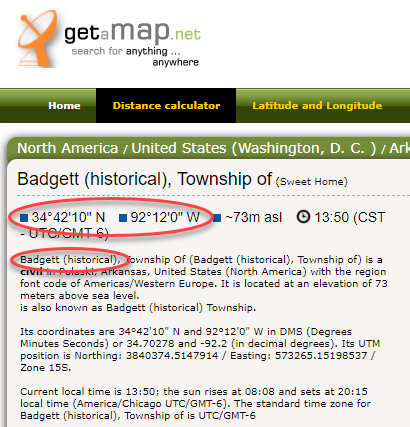
Next, I’ll search for the other location found in the 1940 census, Badgett Township. It doesn’t appear in either Google Earth or Google Maps. That’s probably because it’s been renamed or incorporated. Googling may be able to help so I googled: badgett township arkansas history.
This led me to a website that provided several helpful clues. It says that Badgett is “historical”, meaning that it’s the old name of the town which has since changed. It also provides us with the latitude and longitude of Badgett which we can use in Google Earth to confirm it’s location.
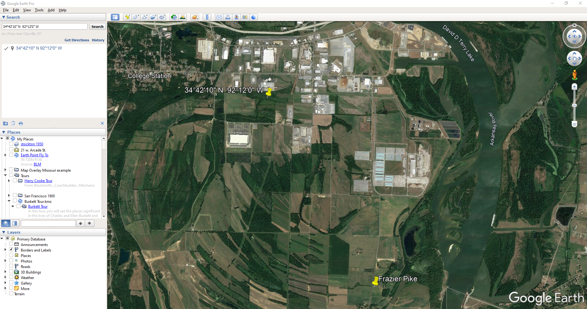
Go back to Google Earth and enter the coordinates (34°42’10” N 92°12’0″ W) in the search box and press ENTER on your keyboard.
The locations are very close.
And indeed, it’s very close to Frazier Pike. (image above)
I also like to look at the image results when googling. The website results are organized by the most relevant images. When I ran a search on Badgett, AR, and click Images on the results page, I see that the first one showed a map showing Frazier Pike. So, they are nearly one and the same.
Another search result was theHome Town Locator website. It says “the Township of Badgett (historical) is a cultural feature (civil) in Pulaski County. The primary coordinates for Township of Badgett (historical) places it within the AR 72206 ZIP Code delivery area.” This confirms that it is historical, the coordinates pin the same place on the map, and the current zip code is the same.
A quick Find on the page search (Alt + F) for Route 2 jumps me to a nice bit of history.
In the section discussing schoolhouses we get a description of the route: “…located in the main red-dirt road called Route 2 in Pulaski County. Route 2 is now known as Frazier Pike.”
Step 4: Find the ED Map for the Closest Census
Next, we turn our attention to the enumeration district or ED number we found on the 1940 census. As you’ll recall, 1940 is the closest available census record to the date of the address, and we found Lisa’s ancestors in that record in Badgett, AR which we now know is the Frazier Pike area in Pulaski county. On that record it says: Badgett Township. ED 60-2B.
We could google for the year of the census and the words enumeration district map. However, there’s a great free tool for finding them over at Steve Morse’s One-Step Tools website at stevemorse.org.
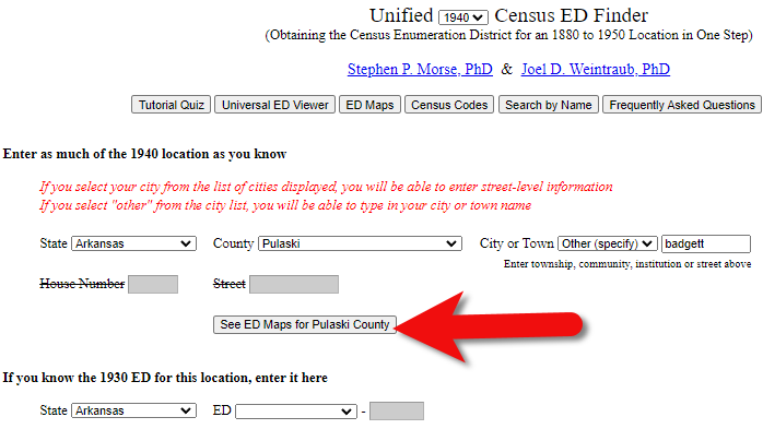
In the menu under U.S. Census select the Unified 1880-1950 Census ED Finder, select the year at the top of the page. In this case we will select 1940. Next, enter the state (Arkansas) and county (Pulaski). You can then select the city or town. However, in the case of rural addresses, don’t expect to find the town listed. If it offers you an “Other” option you can try and type the name of the town (Badgett) in the field provided. Don’t bother entering the route number (Route 2) because that’s not a street address, it’s a postal delivery address.
We could also run this same search on the 1950 census. Chances are you will see more ED numbers listed because the population was growing. Since an enumeration district had to be the size that one enumerator could cover in about a two week timeframe, they were often redivided as they decades went by.
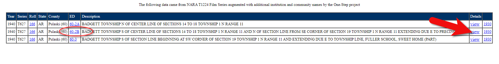
Since we know from the 1940 census that township was in existence, we should receive a list of ED numbers as a result. In this case we got three: 60-2A, 60-2B. and 60-3.
Click the corresponding ED number.
Click the linked ED number that matches the one you found in the census record. In this case, the 1940 census record told us that the Blazer family was in ED 60-2B, so we click that link.
The next page lists each ED. Click the View link for the ED.
Click the View link.
The View link will take you to the exact page for that ED in the ED Descriptions from the National Archives T1224 microfilm from Record Group 29. This description helps even further define the area.
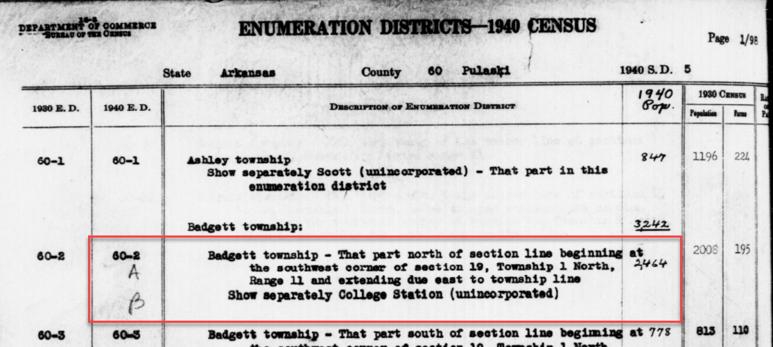
1940 Census ED Description
60-2 A and B says, “Badgett Township – That part north of section line beginning at the southwest corner of section 19, Township 1 North, Range 11 and extending due east to township line. Show separately College Station (unincorporated.)”
This is perfect because its’ giving us the township, range and section! We can use this information to plot it in Google Earth.
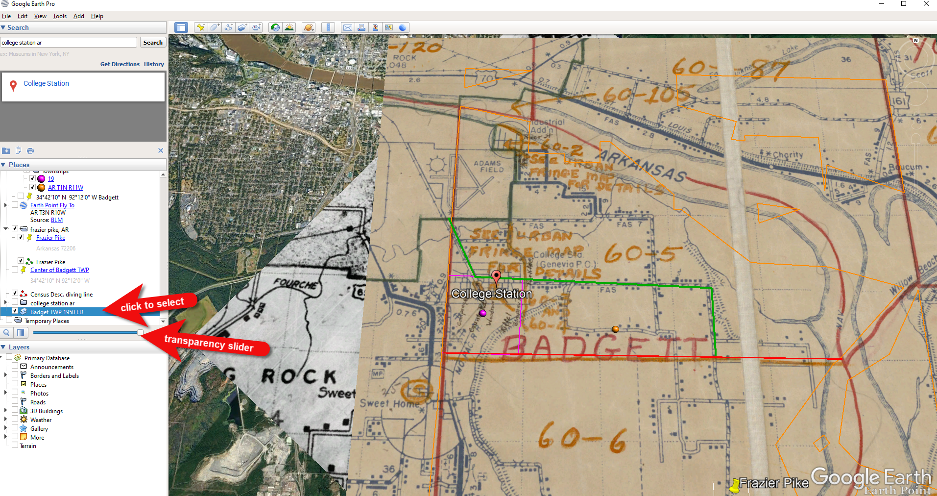
How to plot a land description in Google Earth with Earthpoint:
Enter the state, principal meridian (in this case there’s only one choice here thankfully), township, range and section numbers from the census description.
Click the Fly to on Google Earth button.
This may open automatically in Google Earth or you may be prompted to save the file to your computer. Do that and then click it to open. It is a KMZ file so it will automatically open in Google Earth.
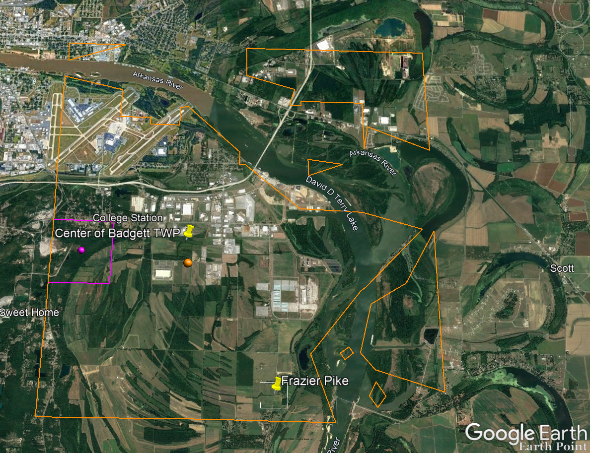
And here are the results! The location is mapped out for you.
Census description mapped in Google Earth.
Notice I still have my placemark pins for the approximate location of Frazier Pike, and the center of Badgett Twp which we got using the latitude and longitude coordinates. Section 19 is outlined in purple, and the township is outlined in orange.
Since Frazier Pike is a road, turn on Roads in the Layers panel. Now we can see that Frazier Pike is running north and south and our pin is right on top of it.
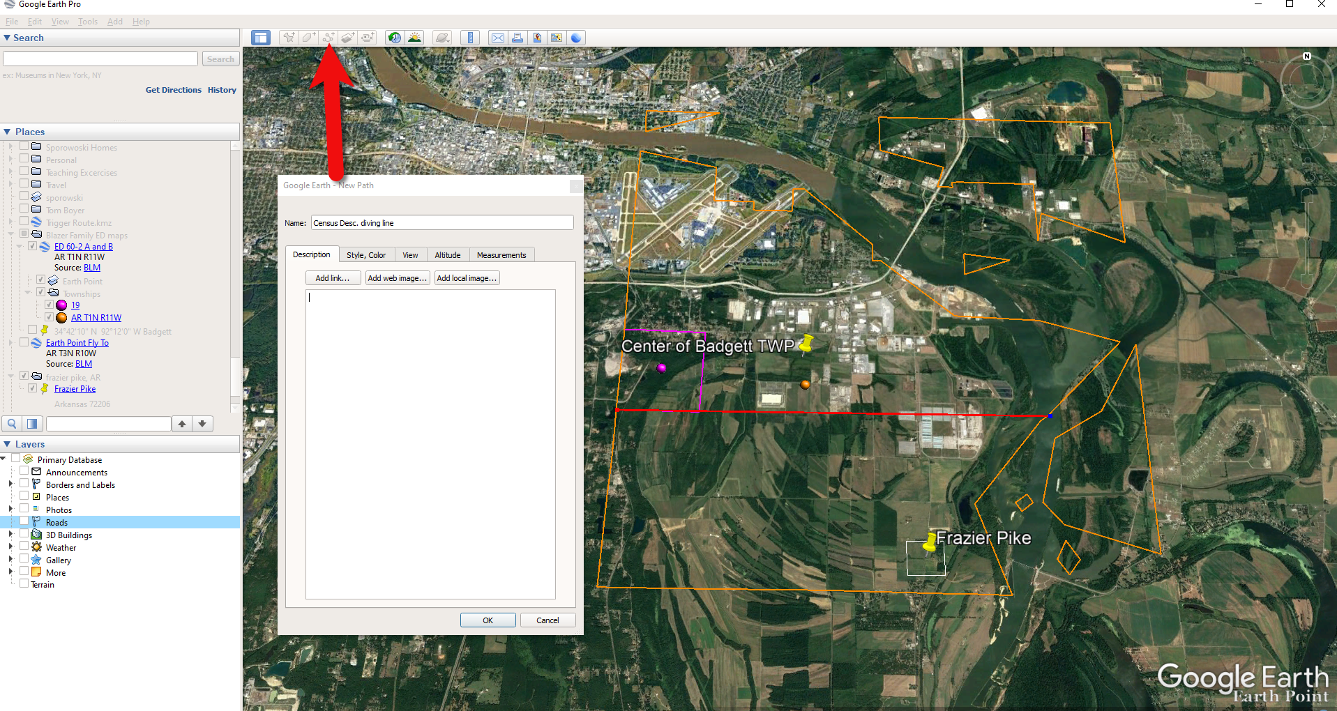
Now we can use the census description to further zero in on the area. “Badgett Township – That part north of section line beginning at the southwest corner of section 19 Township 1 North, Range 11 and extending due east to township line. Show separately College Station (unincorporated.)”
Mark that in Google Earth using the Path tool. Click the Path button in the toolbar at the top oof Google Earth. Click on the southwest corner of section 19 (outlined in purple) and then go east and click the township line (in orange.) Give your path a title and click OK.
Click the Path button in the tool bar.
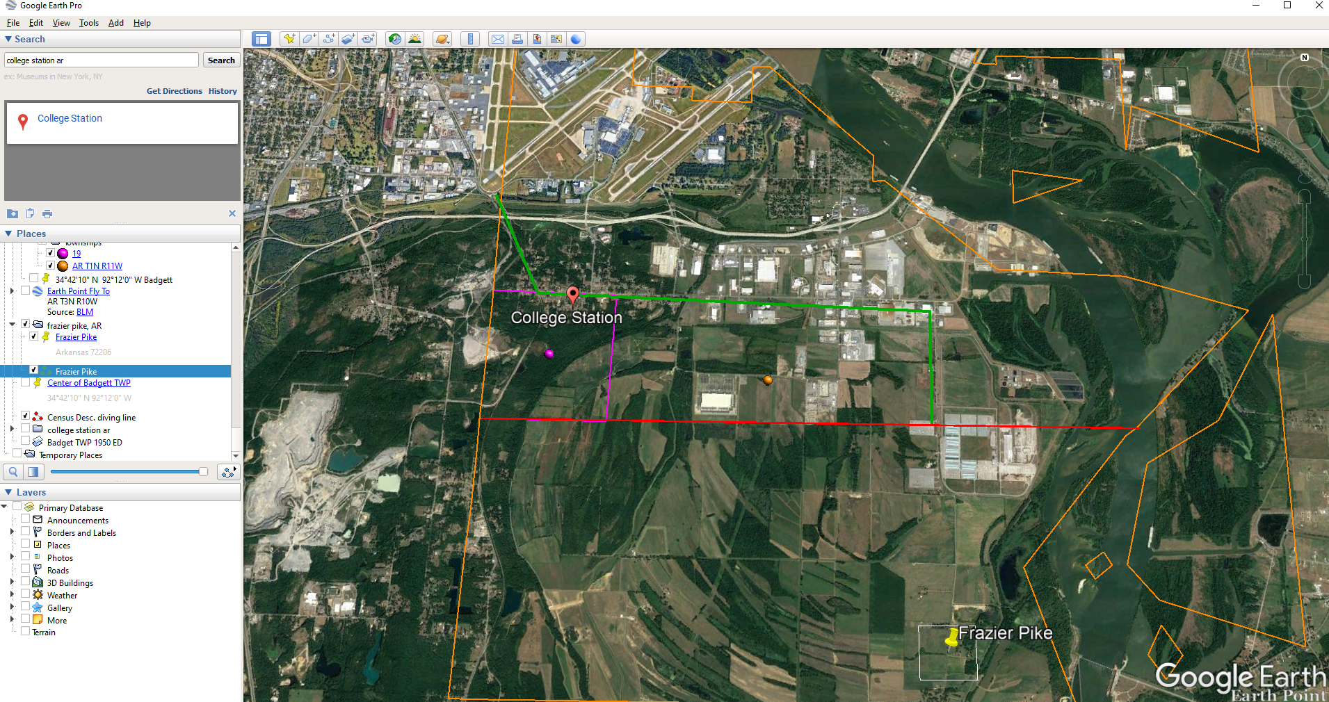
Next in the census description, on the same line as “B” it says “Show separately College Station (unincorporated.)” We can find College Park by searching for College Station, AR in the Google Earth search box.
Next, we want to follow Frazier Pike going north until we are above the section line that started in the southwest corner of Section 19. Use the Path tool again to mark it on the map.
Use the path tool to draw lines in Google Earth.
Get the Enumeration District Map
Now it’s time to head back to Steve Morse’s website and get the ED map for 1940. On the page you started your search, click the See ED Maps for… button.
Click the See ED Maps button.
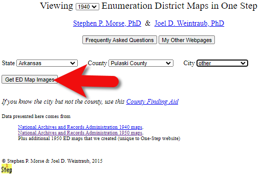
On the next page select the state, county and city again and click the Get ED Map Images button.
Click the Get ED Map Images button.
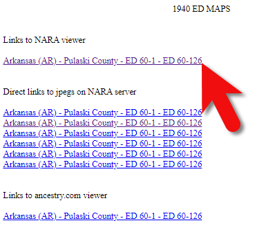
This will take you to a list of all of the available maps. The first link will take you to the National Archives webpage where you can look through all the maps for the area you selected. You could also look through all the individual maps by clicking each of the links listed under “Direct links to jpegs on NARA server”. However, I don’t recommend that will take longer because they are extremely large image files. It’s easier to quickly look through them on the NARA website.
Click the Link to NARA viewer.
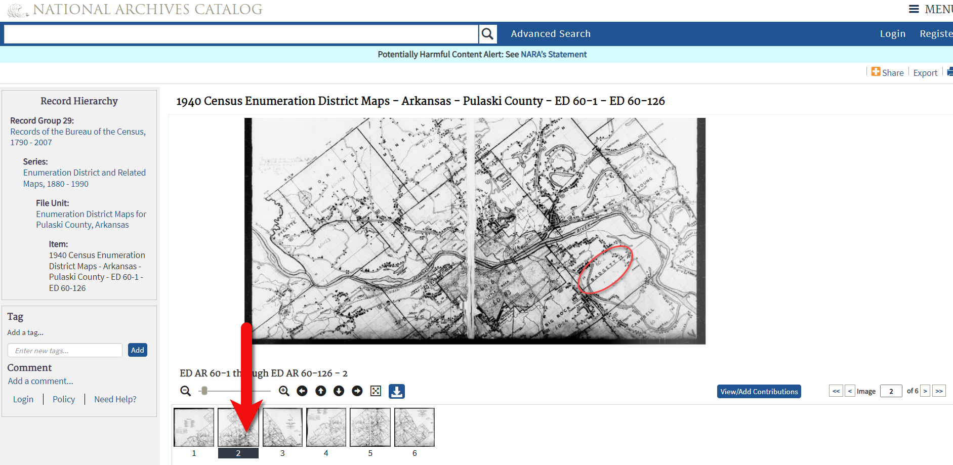
Click the link to the NARA viewer and look for the township name in the map thumbnail images. In this case I’m looking for Badgett. You can do this quickly by clicking each image and then drag the larger map in the viewer around with your mouse. I found Badgett Township in the second map.
Map images at NARA.
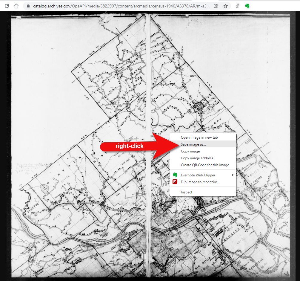
Download the full-sized map by selecting the thumbnail image and then clicking the download button (down arrow.) The full resolution map will load in your web browser. Right-click on it and Save Image As to save it to your computer.
Right-click on the map to save it to your computer.
It can help to create a map overlay in Google Earth using this map. (Learn how to do this in the newest edition of my book The Genealogist’s Google Toolbox.) I cropped the image to just include Badgett Twp.
In fact, you can overlay both the 1940 and 1950 ED maps. Click to select a map in the Places panel and then you can use the transparency slide to fade it to reveal changes.
Select the map and use the opacity slider in Google Earth.
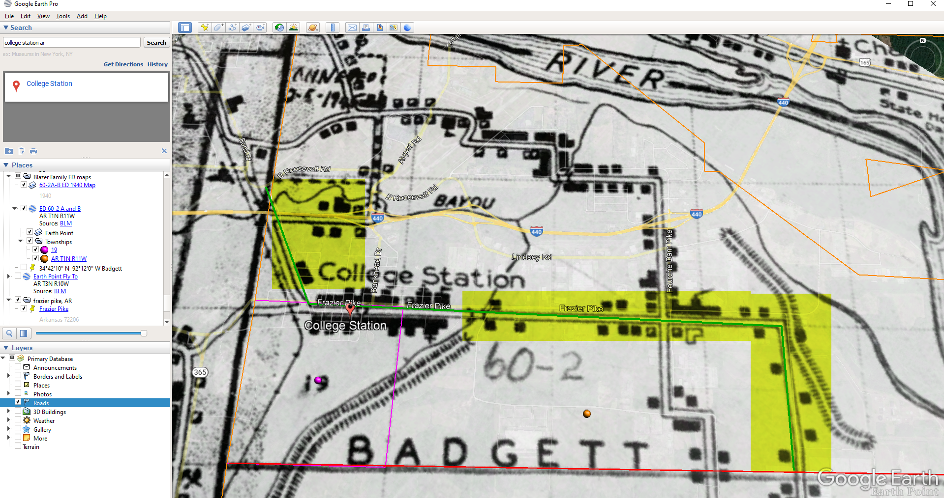
Step 5: Follow the Census
The census can provide even more clues about where in an enumeration district an address was located. Using the census record and the census description of the enumeration district, it can help to highlight the area of the map. In this case, ED 60-2 is “that part north of section line” which I marked with a red path line. The Blazers address was Frazier Pike (which I marked with a green line), so this eliminated the northern area and the Fourche Dam Pike road. To make sure that I could eliminate that area, I verified in the 1940 census that Fourche Dam Pike was enumerated separately by running a keyword search of the Pulaski County census records at Ancestry. And yes, indeed folks living along Fourche Dam Pike were enumerated separately and the road was written along the margin just as Frazier Pike was. This gives me a lot of confidence that I’m identifying the right area.
The route highlighted on the census ED map.
As you can see, there are little black squares and other markings on the map. To find out what each of those means we can turn back to the National Archives and download the page from this map collection that includes the map key.
The black squares are “Farm Units”. A farm unit square is not one family , it is the entire farm, including the owner and other families who may live and work on the farm. We also see businesses, churches, the town hall, school houses and more. We may not be able to find the exact home, but it’s possible to get very close. To do that, we need to head back to the census records themselves.
On Ancestry.com , the Blazers appear on Image 27. The filmstrip makes it easy to quickly scan through the images and browse them.
In this case, there are about 33 images or pages in ED 60-2B. The enumerator would start at one end of Frazier Pike and then make her way to the other. The enumerator wrote “College Station Pike” on pages 1 and 2. That isn’t a road today, and I couldn’t find any references to with a quick search. However, all of the other pages say, “Frazier Pike”. My guess would be that the census taker started on the west side – the hub of College Pike – and made her way east. Census enumerators visited homes and farms in a logical path, although they may have criss-crossed back and forth across the road. They listed the order in which they visited on the census form itself. In cities we might also see house numbers listed, but that’s not the case in a rural area. However, you may see pencil dots with visitation numbers written on the ED map. They were instructed to do this in rural areas in the census enumerator instructions in 1940. Unfortunately, the person enumerating 60-2B did not.
We could also look at the types of businesses and buildings shown on the map, and then look through the census records at occupations. We see a “factory/industrial” building to the east so we would look for people working in that environment in the census and see where they are living. We see a denser population in College Station along with a schoolhouse and two churches, so it would be worth looking through the census pages to see where the school teacher and pastors are listed. Folks may not have lived on the premises, but it would make sense they lived near their work.
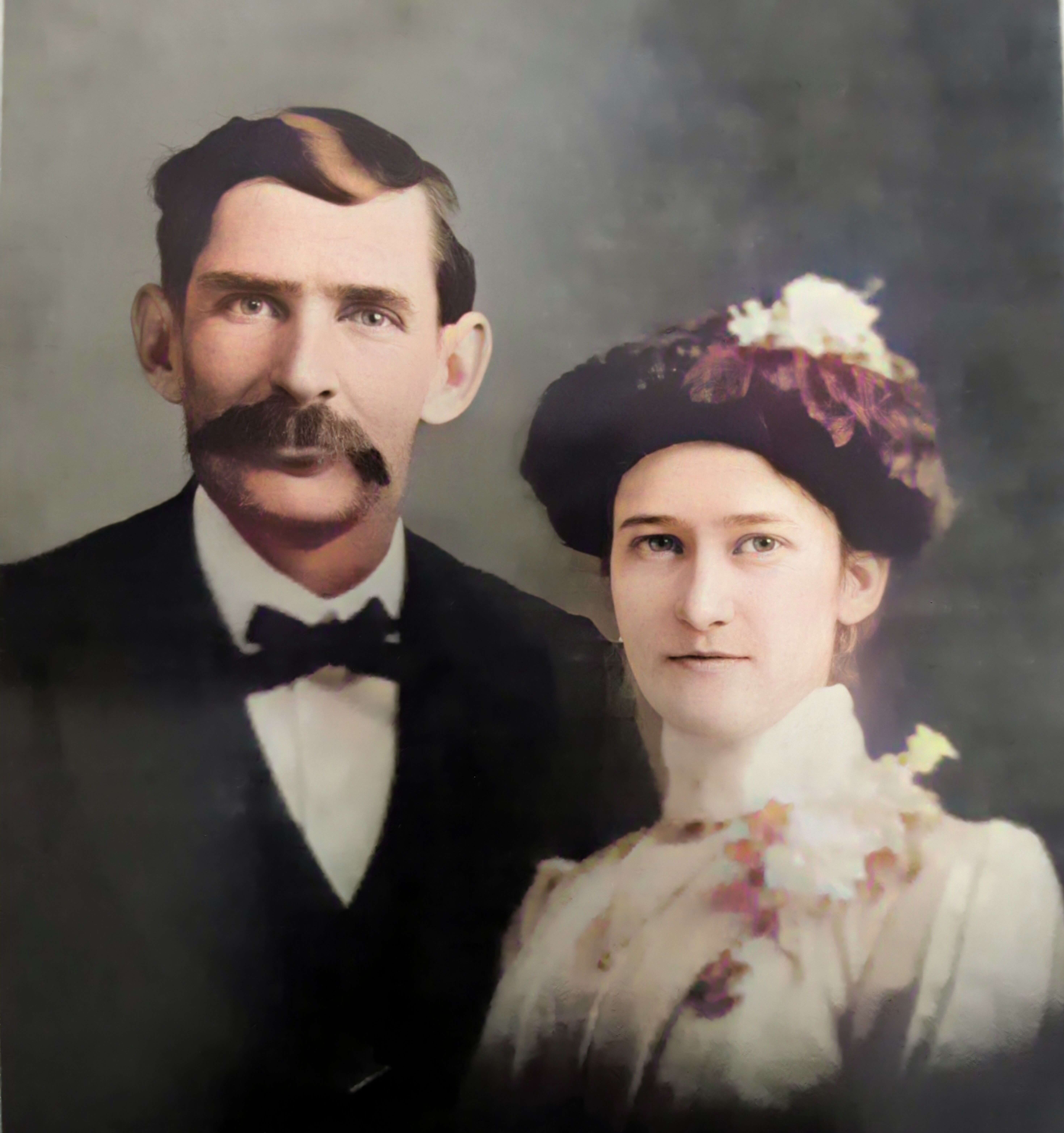
Wedding photo Joseph Madison Blazer Minnie Mae Peters (courtesy of Lisa Egner)
And finally, we want to look for renters and owners. If a family rented, a capital “R” was entered on the census. Those who owned their property were listed with a capital “O”. Since the black squares are “Farm Units” we wouldn’t expect to see a square on the map for every house. If our hypothesis is that the enumerator started on the west side, we could count the number of owned dwellings listed in the census until we get to the family living in question. Then we would count them on the map, going east. Again, it’s not exact, but it’s a whole lot more than what we knew about the address Route 2 Frazier Pike when we started!
Dr. Brian Gurrin is a specialist on Irish censuses and census substitutes and author of such books as Pre-census sources for Irish demography and The Irish religious censuses of the 1760s.
In this week’s video premiere he joins me for a discussion of the incredible story of the repository that held early census records and much more: the Public Record Office of Ireland.
Dr. Gurrin will take us back through the history of the building and the surprising and ironic catastrophes that destroyed countless valuable records. Then he will share the truly inspiring ways that records are being restored, some of which will be available soon!
Video Player (Live) – Watch video premiere at the appointed time in the video player above.
On YouTube (Live) – Click the Watch on YouTube button to watch the YouTube premiere with Live Chat at the appointed time above at the Genealogy Gems YouTube channel. Log into YouTube with your free Google account to participate in the live chat.
Video Player above (Replay) – Available immediately after the live premiere and chat.
If you’re looking for Irish records that were created prior to 1922, and you’re in the right place, today, we are talking about the Beyond 2020 to Ireland project, which may just be the best hope for Irish research in a long time.
Dr. Brian Gurrin is a specialist on Irish census records and substitutes. He’s also the author of the books Pre-census sources for Irish demography and The Irish religious censuses of the 1760s and he’s here today to tell us about this exciting project.
Lisa: What was held at the Public Records Office of Ireland prior to 1922? What kind of records would somebody have found there?
Dr. Gurrin: The Public Record Office (PRO) opened its doors in 1867. Prior to that the Irish records, the various state records, records of Parliament and so on, they were dispersed around in various repositories, around Dublin and around the country. Many of them were stored in locations that were unsuitable for maintaining records in good condition. The records were getting damaged, some records were getting damaged by damp and so on.
So, when the PRO opened, they started to take in records from these unsuitable repositories. There were a vast quantity of records available. Our earliest census records, our first census was held in 1813. That wasn’t a particularly successful census. And then are our next census was the first time that Ireland was fully enumerated by statutory census in 1821. And thereafter, we held censuses every 10 years on a year to terminal digit one. So, we held our census in 1821m 1831, 1841, 1851, and so on, right up to 1911, which was the last census that was held in Ireland, when Ireland was part of the United Kingdom.
And so, they were very important, very important for genealogists. And an interesting thing about the census: when the Public Record Office opened, and it just goes to show how research is changed, they published annual reports every year, the Deputy Keepers Reports. And when they opened, one of the earlier reports, I think it might have been the second report or the third report, made a comment about the census records. It talked about that the census records were just clutter taking up space and that they weren’t very important. And that they were just taking up taking up an enormous, inordinate amount of space in the Public Record Office. They didn’t want to receive any more census records because there were just basically clutter. And when you think about the census and how important the census is for genealogical research and family history research now, it just goes to show how historical research has changed, and how these records are vital records for historical research and historical study.
Overview of the background and contents of Public Record Office of Ireland:
Public Record Office of Ireland opened to public in 1867.
National repository for records:
Census returns (1813-5, 1821, 1831, 1841 & 1851)
State papers
Parliamentary records (Ireland had its own parliament until 1800).
County records; accounts, administration; grand juries.
The building destroyed on 30 June 1922; and almost all records lost.
So it was a really vast collection and it built up from 1867 right up to 1922 when it was still receiving records into the record office.
Let’s just go back and talk about the 1821 census. Again, Ireland’s first census. When that census was held, the census recorded the names of all householders in the country, but also the act that initiated the census specified that at the each of the individual counties where to make a copy of the census as well to hold locally as their own local copy of the census. But then when the county records came in after 1891, after the fire, in the Cork courthouse, all those copies of the 1821 census also came into the Public Record Office as part of the county records collection. In 1922 the Civil War the civil war commenced, and the public record was on the north side of Dublin City in the Four Courts complex, just north of the River Liffey on the north bank.
The anti-treaty IRA occupied the Four Courts complex. We’re not sure what happened. There are two schools of thought. One is that the Anti-treaty IRA deliberately mined the building and blew up the building when they were evacuating it to destroy the records which were primarily records of British administration in Ireland. So, it was a great strike for Irish republicanism, destroying the records of the British administration in Ireland. The second thought on it is that when the anti-treaty IRA started shelling the Four Courts complex to drive out anti-treaty Republican forces there, a shell went in into the Public Record Office, exploding munitions that were stored in the Public Record Office.
Whatever happened, it was quite a disaster for Irish record keeping the beautiful fantastic archive was destroyed. It was explosions that occurred on the 30th of June 1922. It was a catastrophe for Irish history. The building was destroyed, this beautiful archive was destroyed. Records going back 800 years were blown up. The records were scattered around Dublin City. Records were blown on the wind over 10 miles out around Dublin. People were picking them up and handing them back in. There were very little handed back in. It was a catastrophe for Ireland and a really great tragedy. So that’s the backstory.
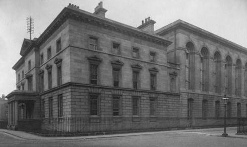
There was two parts to the records office. In designing this, they were really careful to try to ensure that nothing, no catastrophe, could happen that these records could be destroyed. There were two parts to the building. There was a squarish type building (on the left in the photo).
Ireland Public Records Office
That’s called the Record House. That’s where the researchers went. If you want to access records, you went into the Record House, (it was like the Reading Room of the archive) and you filled out a form. You filled out the details of the record you wanted.
The building on the right was called the Record Treasury. It was called the Treasury because these were Ireland’s treasures. This was where Ireland’s treasures were store. It was a beautiful archive containing beautiful records of Irish history over 800 years.
If you look up towards the roof, between the two buildings, you can see a gap. This was a fire break that was that was installed because it was thought that if any fire broke out, it wasn’t going to break out in the Record Treasury, it was going to break out in the record house where the where the public came in and where the heating systems were. So, they wanted to ensure all the collections of records that were in the Record Treasury were going to be protected from fire. So that building isn’t actually joined together. That’s a false wall there. That firebreak gap between the two buildings was to ensure that there was no possibility that a fire could spread from the Record House into the Record Treasury and destroy the records.
The great irony is that when the fire broke out, when the explosions occurred, the explosions occurred in the Record Treasury. That meant that the firebreak operated in reverse protecting the Record House from the Treasury. And by coincidence, whoever was working on records on the day that the record office was occupied, those records were moved from the Treasury to the Record House for them to access. Those records remained in the Record House. So, a small quantity of records survived just by pure accident because people were using them in the Record House at the time. So, the firebreak operated in reverse, protecting the Record House from the fire that was in the Record Treasury even though it was designed with the idea that it would protect the Treasury from any fire that was going to occur in the Record house.
Lisa: Did you say that there was actually munitions stored there?
Dr. Gurrin: Just to take up on the first question that yes, they did. They were really careful to ensure that no damage could come to the records. It wasn’t just that they installed a firebreak, but they also made sure that there was no wood in the Record Treasury to ensure that there was no possibility. So everything was metal. Initially there were wooden shelves in there. But then, maybe 10, 15 years in, the Deputy Keepers annual report says, that’s it, there’s no wood left in here, We have it perfectly protected, so there is no possibility of fire occurring in here.
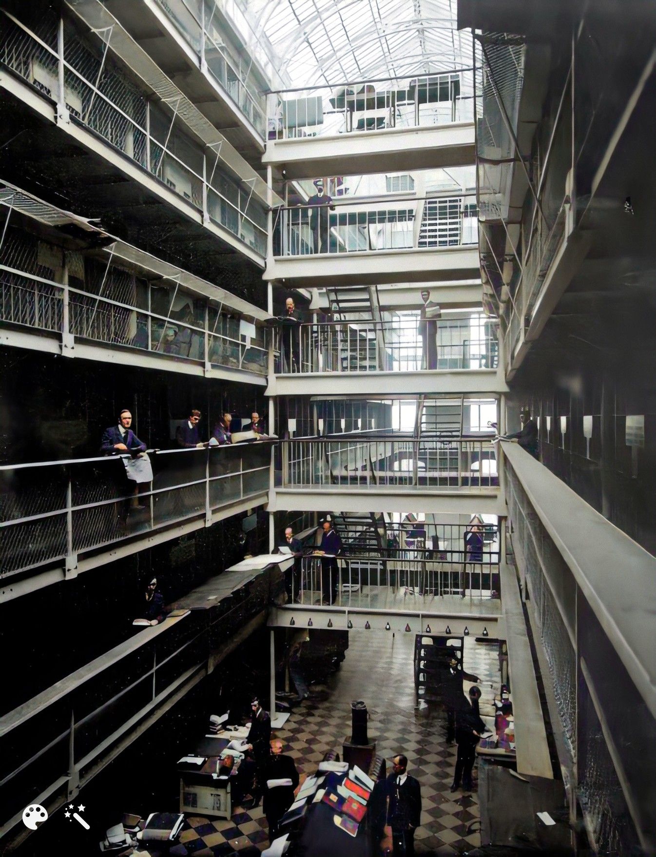
A view inside the Record Treasury:
(enhanced and colorized photo)
There were six floors in that building. You won’t see any wood at all.
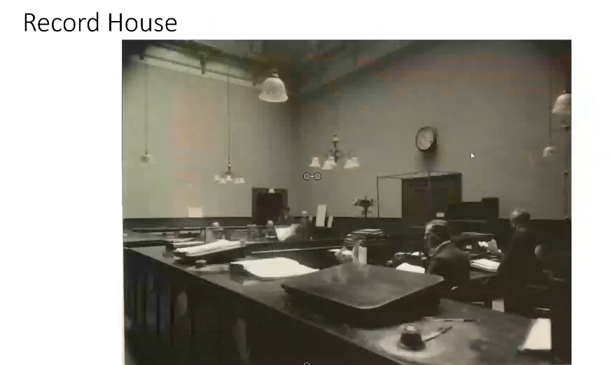
These people are called searchers. So, you go into the Record House:
The Record House
You’d sit down in one of those benches down the back, you’d fill out your document, and you’d hand it up to the clerk behind the desk. They give it to one of the searchers who then goes in through those double doors. That’s the way in between the firebreak and the link into the Record Treasury. They wander up to the steps to whichever floor the record was on and find the record, and bring it back down into the Record House for you.
Now we do have a great knowledge of what was in the Record House.
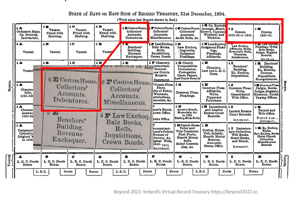
record treasury chart
There was a kind of a central aisle down. On either side there were what were called “bays”. There were six floors to it. This chart is giving you an indication of what was in the Record Treasury and what type of records were in the bays.
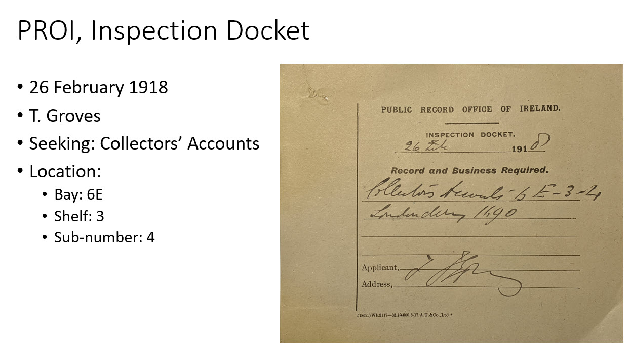
Public Record Office inspection document:
Tennyson Groves was a great hero of mine. He was a genealogist who sat in the Public Record Office and transcribed vast amounts of information from various census records. A lot of what we have surviving now are transcripts that were transcribed by Tennyson Groves.
Lisa: You mentioned the copies of records that were often made. We see that in genealogical records around the world that sometimes copies get made, and then the original set may go to a central location, and then they would keep a set locally. You mentioned that with some of the census records they actually sent the second set into the public records office as well. Do you have a sense of how many duplicates are out there? I mean, how much hope is there that there are copies of some of the things that were in the building and lost that day?
Dr. Gurrin: That’s a really good question.
Once the fire occurred in the courthouse in 1891 in Cork, they said, ‘right, we cannot have, we can’t have a situation where local records are stored in unsuitable accommodation like this. They can’t be destroyed. We have a perfectly fireproof location here. So, we’re going to take them all in.’
So, whatever records counties produced, like as I said, the 1821 census, they were required to make copies. Not all counties produced copies, and not all counties produced complete copies for their county, but many counties did. And many counties produced partial copies. All of those went into the Public Record Office after 1891 as per instructions of the Public Record Office. They all went in except for one county, which is county Cavan. About 40% of the census records survive for Cavan. They were the only county that didn’t send in their local copies into the record office. All the others transferred.
If the fire hadn’t occurred in Cork, maybe the Public Record Office would have let the records stay locally, and they would have survived. In terms of survival of records, Cavan is the only county that copies of the 1821 census survived. Now there are four volumes of 1821 census original volumes that survived. Some bits of partial sets of records have survived. That’s four out of 480 original volumes that existed. So, it’s like 1% of the original volumes from 1821 to survive. But for Cavan 40% of the county is covered by copies that were made under the terms of the census act.
Then there are transcripts for various parts from genealogists and local historians. Prior to 1922, they made copies. But in terms of survival there’s probably about, I suppose, 50 or 60,000 names surviving from 1821 and transcripts. Now that’s 50 or 60,000 names out of the 6.8 million names that were enumerated in 1821. So it’s really, really tragic.
And it’s even worse as you go as you go to the next census for 1831, the survival rate is even lower. And for 1841, it’s very low as well. And there are about two and a half thousand civil parishes in Ireland. And for 1841, there is only one parish that the original record survived. The scale of the losses is just catastrophic.
We are very lucky in that we do have census substitutes. In some instances, we have a wonderful land value taxation valuation that was conducted in the 1860s or in the 1850s called Griffiths Valuation, which is effectively a census substitute. But that’s what we’re down to as Irish genealogy. We’re down to using census substitutes in a lot of instances because unfortunately, this wonderful census records were lost.
There was one other very interesting census that was conducted in Ireland in 1766, a religious census. And that’s a real focus of our project now. It’s a magnificent survey that was conducted that is in the second book of mine that you mentioned. Some original records survive from that as well. So, that’s a really interesting focus of our project, which I could talk for hours!
Lisa: How has this loss of records been coped with over the last 100 years? Were there efforts to try to reconstruct them and fill it back in?
Dr. Gurrin: There were. As soon as the Record Office was reconstructed they did put out calls for records or records transcripts that were taken before 1922. Those came back in and were donated back into the facility. They did make efforts to recover them.
A lot of the records like the charred remains of records that were picked up around the streets of Dublin and in the vicinity of the Four Courts were collected and boxed and cataloged. Many of those records weren’t accessed again until our project started.
The National Archives has been cataloging those records that were picked up almost 100 years ago on the streets of Dublin, and they’ve been cataloging them they’ve been trying to recover them to try to treat them to make them accessible again.
There were various efforts made and donations came in from genealogists like we had a lot of genealogists who transcribed records previous to 1922. If genealogical transcripts came up in auctions the government was very active in trying to secure those. They did as much as they could do, I think, to try to recover the losses, but it was only going to be a drop in the ocean in comparison with what was there.
Lisa: Now you’ve got a brand new project called Beyond 2022. Tell us how this gets started. And what’s your end goal?
Dr. Gurrin: It’s part of the decade of the decade of Centenaries in Ireland. There were a lot of things happening around 1916, with an Easter Rising around 1918, with a general election, which saw Sinn Fein’s win the majority of the seats. It saw the War of Independence, the Civil War, and then the government of Ireland enacted the partition of Ireland. So, it was a lot of things happening around there.
Beyond 2022 really fits into that as a part of the Decade of Centenaries. It’s a two year project that’s been going on with the intention of identifying material that still exists in archives around the world and local archives here in Ireland. It’s an effort to recover it to make it freely available digitally online. They’re being digitally imaged as high-quality digital images. They are being transcribed as much as possible. And that’s not being hand transcribed. This is a transcription package, which is reading the handwriting and trying to transcribe that handwriting into searchable text.
At the end of it, it is the intention of the project to make 50 million words available and searchable through the Beyond 2022 website. So you will be able to enter a name, enter a name, enter a townland name, enter a place name, enter free text and search these documents and come back with whatever we have. The launch date is June 30, 2022.
What questions were asked in the 1950 census? In this week’s video I’ll explain what was asked, and how the answers given can help provide clues for additional research about your family. You’ll also learn what was not asked and which questions were asked for the first time in 1950. Then we’ll wrap up with my Genealogy Pro Tip for the 1950 Census.
Episode 53 Show Notes
We’re all looking forward to the 1950 census coming out in April 2022, followed soon after by the searchable index. But before we dig into it, it’s helpful to know what kinds of questions were asked and what kind of information you can expect to find about you, your parents, your grandparents or even your great grandparents.
If you haven’t watched it already, check out Elevenses with Lisa episode 51 for an overview of the 1950 census.
And I’ll have that video link for you again at the end of this video. And of course the best way to find your own genealogy gems is to follow my genealogy gems channel, so click the YouTube Subscribe button and that will toss me and this channel into your favorites list on YouTube for safe keeping and happy viewing for years to come.
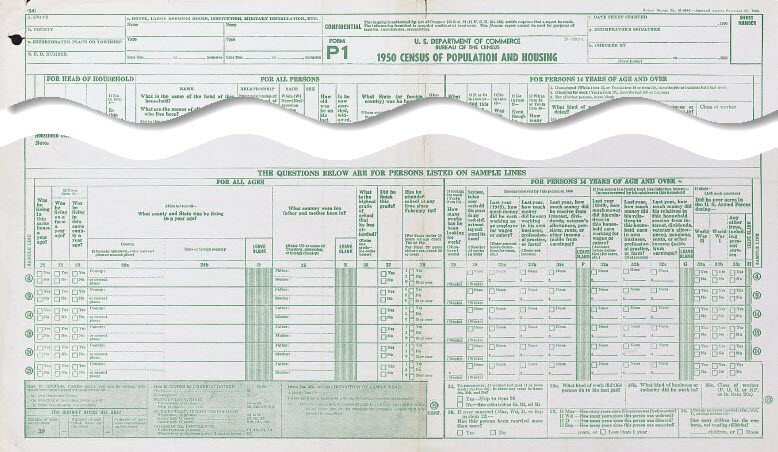
The U.S. Federal Census is taken every 10 years here in the United States. Typically in genealogy we see more and more questions being asked each decade, which is awesome for us as family historians. But did you know that the 1950 population questionnaire actually asked FEWER questions than its predecessor in 1940.
Yep, according to the U.S. Census bureau, in 1940 every household was asked 34 questions. However, in 1950 they were asked just 20 questions. As we go through the questions I’ll let you know what’s the same, what unfortunately you will NOT being seeing, BUT also the few NEW questions that were asked.
Questions Asked on the 1950 U.S. Federal Census Questionnaire
The following questions were asked of everyone in the household.
1. Name of street, avenue or road where the household is located
2. Home or apartment number
3. Serial number of dwelling unit
4. Is this house on a farm (or ranch)?
5. If no, is this house on a place of three or more acres? (New question for 1950 thanks to the expansion of suburbia.)
6. Corresponding agriculture questionnaire number
7. Name
8. Relationship to head
9. Race
Census takers were instructed to assume that all members of the related household were the same race. For unrelated people they were to ask. And if you see a description you are unfamiliar with, consult the 1950 census enumerator instructions.)
10. Sex
11. How old was this person on his last birthday?
It was expected that there would be some folks who either didn’t know their exact age or didn’t care to share it. Census takers were instructed to try to zero in and get as accurate as possible. If age wasn’t known, they were instructed to enter an estimate as the very last resort, and footnote that it was an estimate.
12. Is this person now married, widowed, divorced, separated, or never married?
Marriage codes found in this column:
MAR = married
WD = widowed
D = divorced
SEP = separated
NEV = never married. People under the age of 14 were automatically labeled as never married. Also, common-law marriages were reported as Married, so while marital status can be an indicator to look for marriage records, it is possible that there may not be any.
13. What State or country was the person born in?
It’s important to note that if the baby was born in a hospital across the state line, they were reported as being born in the state where the family lived. This is important to keep in mind when hunting for birth certificates.
14. If foreign born, is the person naturalized?
This will be a yes or no. But if you see “AP” it means the person was born of American parents abroad or at sea. Also, if born at sea they were an American citizen if their father was, or if they were born after 5/24/1934 and either parent was American.
Before we get to the last six questions which were asked only of people 14 years of age and older, let’s take a look at the questions you might have expected to see that were asked in the previous 1940 census but were not.
Questions Not Asked in the 1950 Census that Were Asked in 1940
These questions include:
Home owned (O) or rented (R)
Value of home or monthly rental if rented
Attended school or college at any time since March 1, 1940?
Highest grade of school completed
Residence, April 1, 1935
City, town or village having 2,600 or more inhabitants. If less, enter “R”
County
State (or Territory or foreign country)
Farm?
Questions Asked in the 1950 Census of People Over the Age of 14
You may be wondering why the last 6 questions of the 1950 census were only asked of people over the age of 14. It’s because these questions were about employment status. Not surprisingly, these questions vary a bit from what was asked about in employment in 1940, but they are pretty similar.
What was this person doing most of last week – working, keeping house, or something else?
Employment Codes used in questions 15:
WK = working
H = keeping house
U = unable to work
OT = other
16. If the person was “keeping house” or “something else” in question 15, did the person do any work at all last week, not counting work around the house? (Including work-for-pay, in his own business, working on a farm or unpaid family work)
17. If the person answered “no” to question 16, was he looking for work?
18. If the person answered “no” to question 17, even if he didn’t work last week, does he have a job or business?
19. If the person was working, how many hours did he or she work in the last week?
20. What kind of work does the person do?
What kind of business or industry is the person in?
Class of worker the person is.
Enumerators were to mark “P” for private employment, “G” for government employment, “O” for own business, or “NP” for working without pay
Here’s an example of an entry you might see for someone’s employment: Jewelry, Salesman, P. Armed forces was used for all types of military service.
The one glaring omission in 1950 is questions about whether the person worked for one of the government program such as the Works Progress Administration known as the WPA or The Civilian Conversation Corp known as the CCC. This actually makes sense because these employment programs were focused on helping the unemployed during the Depression. WWII had most Americans working and doing their part in some fashion creating low unemployment. Therefore, the WPA was ended in 1943.
Genealogy Clues in the 1950 Census
Let’s quickly recap what you will learn from the answers to the questions asked during the 1950 census that can help you learn more about your family history:
You’ll see the names of your relatives and ancestors, where they lived and the relationships within the family.
You’ll find out where they were living and get the actual address. You can then use this information to find old maps, search city directories and learn much more about their neighborhood and their lives.
If your relatives lived on a farm you’ve got another genealogy gem to find which is their listing in the Agricultural census. Remember the population enumeration, the one counting people, is just one of the enumerations that was conducted. The 1950 population enumeration will give you the number where you can locate them in the agricultural questionnaire.
You’re also going to learn your relative’s age which will get you even closer to determining their birthdate. This in turn will help you locate their birth records. You will also learn the state or country where they were born.
If they were foreign born you will find out if they were naturalized. It’s a little disappointing that it doesn’t tell us the year of immigration or naturalization. However, a “yes” in the “is the person naturalized” column does provide you with an excellent clue to go look for those naturalization records. Learn more about finding and using naturalization records for genealogy in my FamilyHistory: Genealogy Made Easy podcast:
Episode 29: Immigration and Naturalization Records for Family History, Part 1.
Genealogy lecturer and blogger Stephen Danko, PhD, begins a 3-part series on U.S. immigration and naturalization records. Learn about passenger arrival lists in the U.S., little-known certificates of arrival and naturalization records: how to find them and what’s in them.
And finally, you’ll not only find out if they were married and if they had any previous marriages.
Lisa’s Pro Tip for the 1950 U.S. Census
After my first video on the 1950 census I got this question from Suzanne: Will the 1950 census also have the children born to mother/children still living question?
The answer is, maybe.
Pro Tip: Keep an eye out for additional questions.
As in 1940, 5 percent of the population were asked an additional slate of questions. This was to provide sample data about the population. One of those questions asked was “If female and ever married, how many children has she ever borne, not counting stillbirths?”
Supplemental Questions Asked in the 1950 Census
Here are the additional questions that were asked of just 5% of the population in the 1950 U.S. Federal Census. (Note: They were asked of all ages.)
21. Was the person living in the same house a year ago? If the answer was no, then…
22. If no to question 21, was the person living on a farm a year ago?
23. If no to question 21, was the person living in the same county a year ago?
24. If no to question 23…
What county (or nearest place) was he living in a year ago?
What state or foreign country was he living in a year ago?
25. What country were the person’s mother and father born in?
26. What is the highest grade of school that the person has attended?
Enumerators were to mark “0” for no school; “K” for kindergarten; “S1” through “S12” depending on the last year of elementary or secondary school attended; “C1” through “C4” depending on the last year of undergraduate college education attended; or “C5” for any graduate or professional school.
27. Did the person finish this grade?
28. Has the person attended school since February 1st?
Enumerators could check a box for “yes” or “no” for those under thirty; for those over thirty, they were to check a box for “30 or over.”
For members of the household who were 14 years and older, they also answered these questions centered around employment details, money, military service previous marriages and the question Suzanne is hoping to have answered – children born to women in the household.
1950 census supplemental questions asked of 5% of the population.
29. If the person is looking for work, how many weeks has he been looking for work?
30. Last year, how many weeks did this person not work at all, not counting work around the house?
31. Last year, how much money did the person earn working as an employee for wages or salary?
32. Last year, how much money did the person earn working at his own business, professional occupation, or farm?
33. Last year, how much money did the person receive from interest, dividends, veteran’s allowances, pensions, rents, or other income (aside from earnings)?
34. If this person is the head of the household: last year, how much money did his relatives in this household earn working for wages or salary?
35. If this person is the head of the household: last year, how much money did the person earn working at his own business, professional occupation, or farm?
36. If this person is the head of the household: last year, how much money did the person receive from interest, dividends, veteran’s allowances, pensions, rents, or other income (aside from earnings)?
37. If male: did he ever serve in the U.S. Armed Forces during…
World War II
World War I
Any other time, including present service
38. To enumerator: if the person worked in the last year, is there any entry in columns 20a, 20b, or 20c?
39. If yes, skip to question 36; if no, make entries for questions 35a, 35b, and 35c.
What kind of work does this person do in his job?
What kind or business or industry does this person work in?
Class of worker
40. If ever married, has this person been married before?
41. If married, widowed, divorced, or separated, how many years since this event occurred?
42. If female and ever married, how many children has she ever borne, not counting stillbirths?
The 1950 U.S. Census – A Valuable Genealogical Record
So now you know all the details on what you can look forward to learning about in the 1950 census. If you would like to learn more about the 1950 census, watch The 1950 Census for Genealogy. You can watch the video and get the complete show notes here.
WATCH NEXT: episode 51 and get the show notes here.
Yakety Yak – Talk Back in the Comments
Elevenses with Lisa is a genealogy community, and discussion is a big part of the experience. In the Comments below please share on one of these topics:
What question are you most looking forward to getting an answer to in the 1950 census?
Who you’re hoping to find in the 1950 census?
What question do you have for me about the 1950 census?
 If you have Canadian kin, you’ll be pleased to hear that the 1825 census of Lower Canada is now searchable online, and the 1921 census will soon be available online, too!