 Have you ever found yourself looking for an ancestor’s address that doesn’t seem to exist anymore? Here are some strategies I recently shared via the following Q&A:
Question: From the 1881 Census in England I uncovered the address for my relative: 3 Buckingham Mews, Kensington Place, London, England. When I enter this in the search it gives me 3 Buckingham Mews, Westminster, London,UK.
I don’t know anything about London so I don’t know if this is the same thing but just with current location names. Any suggestions?
My Answer: As with many genealogical questions, this is a question that will likely require several sources in order to answer. I’ve been to London many times and my perception is that Kensington and Westminster are separate areas. Boundaries have certainly changed over the years in London, and England at large though. Here is the direction I would suggest:
1) Google Earth – a search of 3 Buckingham Mews, Kensington actually delivers 3 possible locations (2 in “London” and 1 in “Westminster”). You can save each one to My Places (I would recommend creating a folder especially for this question). At the bottom of the results list you will see an icon that looks like a folder with a down arrow. Click it to download the locations to MyPlaces. Also, be sure to run a search simply on “3 Buckingham Mews” and let Google Earth show you all the possibilities.
2) Go back to your original source: the census. Since there is confusion about the address of your ancestor, look for other addresses listed nearby and plot those in Google Earth. My hunch is that you will begin to build a profile of the census area, and see the relationship between that neighborhood and the 3 results Google Earth delivered.
3) Check Rumsey Historical Maps in Google Earth – LAYERS > GALLERY > RUMSEY (click the Rumsey box). You may need to zoom out a bit to locate the available historical maps. You’ll find that there is one from 1842.
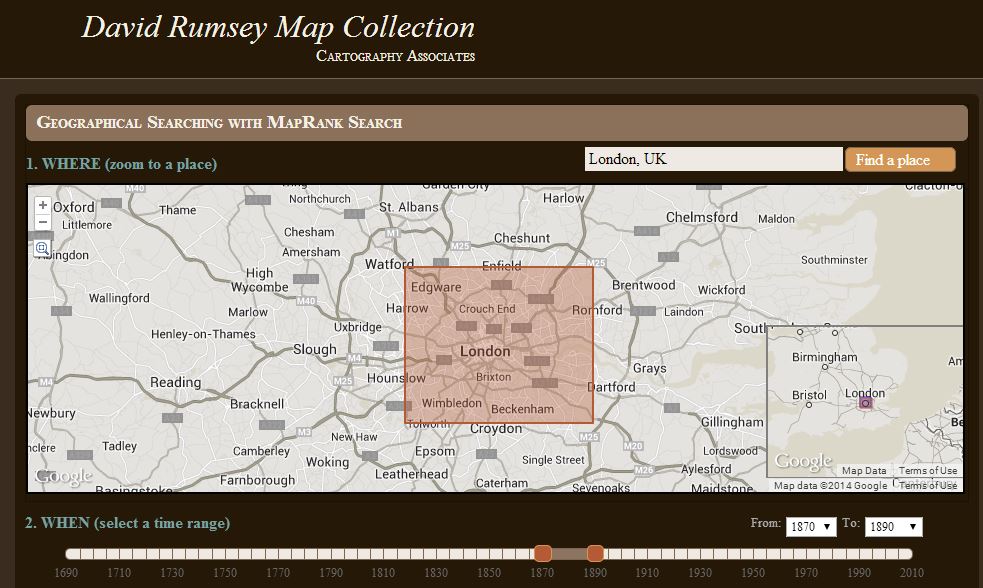
4) Search for applicable maps at the David Rumsey Historical Map Collection. On the home page scroll down and click “Launch Map Rank Search.” From that page you can select London, and then narrow in on the time frame. I would go for a spread of 1870-1890 (see below: you’ll move both pink boxes to set the time parameters on the timeline). There are several excellent maps available to download from that query. Sign up for a free account on the website and you will be able to download the highest resolution maps. You can also, of course, work with the map right on the website.
5) Google Search – Run some searches on the history of London boundaries and boroughs. Here’s a link to a page a found in Wikipedia on “London boroughs.”
By exploring multiple sources you should be able to create a “data visualization” that zeros in on the correct location. I hope you’ll share what you find with me!
Want to learn more about using Google Earth for genealogy? I offer a 2-CD bundle that demonstrates how to:
- download and use Google Earth;
- identify where old pictures were taken;
- explore church record origins;
- plot ancestors’ homesteads and pinpoint their properties;
- create custom historic map overlays;
- save and share images and videos;
- customize placemarks;
- create 3D models of ancestral locations; and
- create unique family history tours. Click here to learn more!